|
|
|
| Research on the sharing service system of magnetotelluric data in geological cloud |
Bin FENG1( ), Meng LIANG1, Wen-Li WU1, Xue-Li ZHANG2(), Bing-Rui DU1, Na MA2 ), Meng LIANG1, Wen-Li WU1, Xue-Li ZHANG2(), Bing-Rui DU1, Na MA2 |
1. Institute of Geophysical and Geochemical Exploration of Chinese Academy of Geological Sciences,Langfang 065000,China
2. Geological Information Center,East China Mineral Exploration and Development Bureau,Nanjing 210007,China |
|
|
|
|
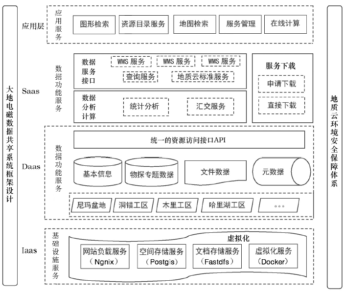
Abstract A service system for magnetotelluric data sharing is proposed to solve the management and sharing of magnetotelluric data.This paper discusses the cloud architecture design, function design and other aspects, focusing on the integration of electromagnetic operations such as phase diagram in the system. Finally, a prototype system is built based on the electromagnetic data of Nima basin. Compared with the traditional sharing system, the interface of this system completely follows the "geological cloud" standard, which provides the premise of exploration practice for the magnetotelluric thematic service in the "geological cloud" sharing.
|
|
Received: 17 February 2020
Published: 28 August 2020
|
|
|
|
Corresponding Authors:
Xue-Li ZHANG
E-mail: fengbin@igge.cn;273907398@qq.com
|
|
|
|
|
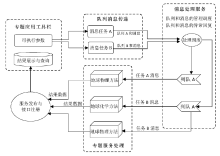
Flow chart of geological data visualization system
|

| 序号 | 参数名称 | 字段名称 | 数据类型 | 是否可为空值 | | 1 | 工区编号 | area | 字符 | 否 | | 2 | 施工编号 | ei | 字符 | 否 | | 3 | 测线编号 | line | 字符 | 否 | | 4 | 测点编号 | station | 字符 | 否 | | 5 | 测点坐标x(经度) | coorx | 实数(双精度) | 否 | | 6 | 测点坐标y(纬度) | coory | 实数(双精度) | 否 | | 7 | 测点坐标x(投影) | x | 实数(双精度) | 是 | | 8 | 测点坐标y(投影) | y | 实数(双精度) | 是 | | 9 | 高程 | z | 实数(双精度) | 是 | | 10 | 周期 | period | 实数(双精度) | 否 | | 11 | 视电阻率(xy) | rxy | 实数(双精度) | 是 | | 12 | 视电阻率(yx) | ryx | 实数(双精度) | 是 | | 13 | 相位(xy) | pxy | 实数(双精度) | 是 | | 14 | 相位(yx) | pyx | 实数(双精度) | 是 | | 15 | 阻抗Zxy实部 | zxyr | 实数(双精度) | 是 | | 16 | 阻抗Zxy虚部 | zxyi | 实数(双精度) | 是 | | 17 | 阻抗Zyx实部 | zyxr | 实数(双精度) | 是 | | 18 | 阻抗Zyx虚部 | zyxi | 实数(双精度) | 是 | | 19 | 阻抗Zxx实部 | zxxr | 实数(双精度) | 是 | | 20 | 阻抗Zxx虚部 | zxxi | 实数(双精度) | 是 | | 21 | 阻抗Zyy实部 | zyyr | 实数(双精度) | 是 | | 22 | 阻抗Zyy虚部 | zyyi | 实数(双精度) | 是 | | 23 | 倾子Tzx实部 | tzxr | 实数(双精度) | 是 | | 24 | 倾子Tzx虚部 | tzxi | 实数(双精度) | 是 | | 25 | 倾子Tzy实部 | tzyr | 实数(双精度) | 是 | | 26 | 倾子Tzy虚部 | tzyi | 实数(双精度) | 是 |
|
Platform development tool
|
|
Flow chart of magnetotelluric processing based on message queue
|
| 实施开发工具 | 功能描述 | | Play | 基于Java的网站开发框架,用于开发网站 | | PostGIS | 空间数据库,支撑大地电磁空间数据的存储 | | Redis | 内存数据库,存储相关时效性数据 | | RabbitMq | 调度服务器,异构环节中间组建,屏蔽系统开发语言差距 | | Ngnix | 解决负载均衡与反向代理,同时提供网站运行服务的web服务器 | | ArcGIS js | 地图前台框架 | | ArcGIS Server | GIS服务器,服务发布空间数据,以WMS 提供服务 | | Docker | 云虚拟化服务器 |
|
Platform development tool
|
|
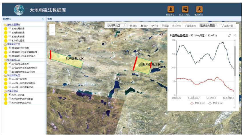
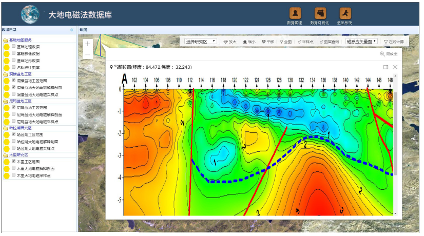
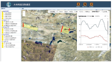
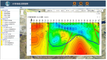
Main interface of magnetotelluric data sharing service
|
|
MT query view in application
|
| [1] |
谭永杰. 地质大数据与信息服务工程技术框架[J]. 地理信息世界, 2016,23(1):1-9.
|
| [1] |
Tan Y J. Architecture and key issues of geological big data and information servive project[J]. Geomatics World, 2016,23(1):1-9.
|
| [2] |
高振记, 谢华锋, 李志伟, 等. 油气资源地质调查大数据架构与应用研究[J]. 地理信息世界, 2016,23(1):18-23.
|
| [2] |
Gao Z J, Xie H F, Li Z W, et al. Research on the architecture and application of the big data in oil and gas geological suervey[J]. Geomatics World, 2016,23(1):18-23.
|
| [3] |
姜作勤, 马智民, 杨东来, 等. 地质信息服务体系框架研究[J]. 中国地质, 2007,34(1):173-178.
|
| [3] |
Jiang Z Q, Ma Z M, Yang D L, et al. Framework of the geological information service system[J]. Geology in China, 2007,34(1):173-178.
|
| [4] |
缪谨励, 屈红刚, 许哲, 等. 地学大数据技术研究实验平台GeoBDA[J]. 地理信息世界, 2014,21(6):48-52.
|
| [4] |
Miao J Q, Qu H G, Xu Z, et al. The experimental platform of technical study of the big data of geoscience:GeoBDA[J]. Geomatics World, 2014,21(6):48-52.
|
| [5] |
刘荣梅, 严光生, 夏庆霖. 从第34届国际地质大会看地学信息技术发展趋势[J]. 地质通报, 2013,32(4):685-692.
|
| [5] |
Liu R M, Yan G S, Xia Q L. The progress and development trend of the geoscience information technology viewed from the abstracts submitted to the 34th IGC held in Brisbance, Australia[J]. Geological Bulletin of Chian, 2013,32(4):685-692.
|
| [6] |
苏国辉, 申延平, 孙记红, 等. 全球油气地质信息共享系统[J]. 地球信息科学学报, 2012,14(2):217-222.
|
| [6] |
Su G H, Shen Y P, Sun J H, et al. The global oil and gas geology database information sharing system based on arcgis server[J]. Journal of Geo-Information Science, 2012,14(2):217-222.
|
| [7] |
张学利, 宋震, 刘晓, 等. 地勘基金成果管理系统的设计与开发[J]. 国土资源信息化, 2017(4):41-45.
|
| [7] |
Zhang X L, Song Z, Liu X, et al. The design and development of the results management system regarding to the geological processing fund[J]. Land and Resources Information, 2017(4):41-45.
|
| [8] |
徐效波, 吴华玲, 王建强, 等. 煤矿安全生产信息系统的设计与实施[J]. 地球信息科学学报, 2012,14(4):454-459.
|
| [8] |
Xu X B, Wu H L, Wang J Q, et al. Development and application of the coal mine satety producion system based on GIS[J]. Journal of Geo-Information Science, 2012,14(4):454-459.
|
| [9] |
王卷乐, 游松财, 谢传节, 等. 面向Web的地学数据共享服务平台架构设计[J]. 地球信息科学, 2004,6(4):62-65.
|
| [9] |
Wang J L, You S C, Xie C J, et al. Study on Web-oriented geo-data sharing platform system strcuture[J]. Journal of Geo-Information Science, 2004,6(4):62-65.
|
| [10] |
胡磊, 乐鹏, 龚健雅, 等. 异步地理信息网络处理服务方法研究[J]. 武汉大学学报:信息科学版, 2016,41(5):679-685.
|
| [10] |
Hu L, Yue P, Gong J Y, et al. An Approach to asynchronous geoprocessing service[J]. Geomatics and Information Science of Wuhan University, 2016,41(5):679-685.
|
| [11] |
Fitch P, Bai Q F. A standards based web service interface for hydrological models[C]// 18th World IMACS/MODSIM Congress, Cairns, Australia, 2009-07-13.
|
| [12] |
Feng M, Liu SG, Euliss Jr, et al. Prototyping an online wetland ecosystem services model using open model sharing standards[J]. Environmental Modelling & Software, 2011(26):458-468.
|
| [13] |
张学利, 马娜, 杨燕, 等. 基于消息调度机制的地质服务体系构建与应用实践[J]. 国土资源遥感, 2019,31(1):271-276.
|
| [13] |
Zhang X L, Ma N, Yang Y, et al. Development and application of the geological processing servive system based on message scheduling[J]. Remote Sensing for Land and Resources, 2019,31(1):271-276.
|
| [14] |
张学利, 马娜, 朱瑜馨, 等. 基于云平台的农业综合信息应用系统的设计与开发[J]. 地理空间信息, 2019,17(2):27-30.
|
| [14] |
Zhang X L, Ma N, Zhu Y X, et al. Development and design of the agriculture comprehesive information application system based on cloud platform[J]. Geospatial Information, 2019,17(2):27-30.
|
| [15] |
Yang J. Convergence and uncertainty analyses in Monte-Carlo based sensitivity analysis[J]. Environmental Modelling & Software, 2011,4(26):444-457.
|
| [1] |
CHEN Da-Lei, WANG Run-Sheng, HE Chun-Yan, WANG Xun, YIN Zhao-Kai, YU Jia-Bin. Application of integrated geophysical exploration in deep spatial structures: A case study of Jiaodong gold ore concentration area[J]. Geophysical and Geochemical Exploration, 2022, 46(1): 70-77. |
| [2] |
CHEN Jun, YAN Liang-Jun, ZHOU Lei. Denoising of magnetotelluric data based on Hilbert-Huang transform[J]. Geophysical and Geochemical Exploration, 2021, 45(6): 1462-1468. |
|
|
|
|