|
|
|
| Distribution characteristics of structural units in Xincai iron ore area based on gravity and magnetic field characteristics |
ZHANG Lei1,2,3( ), WANG Wan-Yin2,3, ZHAO Xiu-Jun1, ZHANG Yi-Mi2,3 ), WANG Wan-Yin2,3, ZHAO Xiu-Jun1, ZHANG Yi-Mi2,3 |
1. Aero Geophysical and Remote Sensing Center of Henan Province,Zhengzhou 450053,China
2. Institute of Gravity and Magnetic Technology,Chang'an University,Xi'an 710054,China
3. College of Geological Engineering and Geomatics,Chang'an University,Xi'an 710054,China |
|
|
|
|
Abstract The Xincai iron ore district is located in the southeast of Wuyang Xincai iron ore metallogenic belt in Henan Province. It is covered with thick Cenozoic strata. The magnetite orebody mainly occurs in the Archean Taihua Group. Due to the underutilization of large-scale geophysical data and other reasons, the division of structural units in the area remains in the result of small-scale division, which restricts the deep exploration breakthrough in this area. In this paper, through the processing and interpretation of large-scale gravity and magnetic data, the spatial distribution characteristics of fault structures and strata in the area were studied. The study shows that there are six main faults in the Xincai iron ore district, which strike NW and NE, and control the basement structural framework; the basement depression area is V-shaped, and the center and both sides of V-shaped are the basement uplift areas. Among the structures, Chendian uplift and Liancun fanghudian uplift were caused by Archean Taihua rock group. The study of magnetic anomalies in this area will help to realize the deep iron ore prospecting breakthrough and hence is of great significance.
|
|
Received: 14 February 2020
Published: 28 August 2020
|
|
|
|
|
|
|
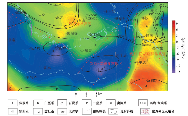
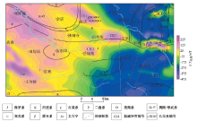
Geological Sketch of the study area (Geological Bureau of Henan Province, 1978)
|

| 地层 | 主要岩性 | 标本数 | 极小值 | 极大值 | 平均值 | 密度界面 | 备注 | | 第四系(Q) | 黏土 | 92 | 1.60 | 2.20 | 1.94 | 1.94 | 项目实测 | | 新近系(N) | 灰质泥岩、黏土 | 21 | 2.25 | 2.26 | 2.30 | 2.38 | | | 古近系(E) | | 577 | | | 2.38 | | | | 白垩系(K) | 英安岩、角砾岩、凝灰岩、花岗斑岩 | 43 | 1.97 | 2.68 | 2.45 | 2.52 | | | 侏罗系(J) | 砂岩 | 91 | 1.88 | 3.52 | 2.52 | | 项目实测 | | 三叠系(T) | 砂岩 | 58 | 1.84 | 3.42 | 2.58 | | 项目实测 | | 二叠系(P) | 砂质泥岩、细粒砂岩、粉砂岩、泥岩 | 708 | | | 2.50 | | | | 石炭系(C) | 石灰岩、砂岩 | 381 | | | 2.57 | | | | 奥陶系(O) | 页岩、白云质灰岩 | 814 | | | 2.68 | 2.67 | | | 寒武系(∈) | 石英砂岩、灰岩、砂光岩、含碳质片岩、石英
岩、灰绿色绢云片岩、石煤、竹叶状灰岩 | 125 | 2.20 | 2.86 | 2.68 | | | | 震旦系(Z) | 砾岩、泥岩等 | 568 | | | 2.65 | | | | 新太古界太华岩群(Ar3Th) | 片麻岩 | 30 | 1.81 | 3.67 | 2.79 | 2.79 | 项目实测 | | 磁铁矿 | | | | 2.95 | | |
|
Statistical table of main strata and mineral density in the study area103 kg/m3
|
| 地层 | 岩性 | 标本数 | κ | 备注 | | 新近系 | 黄土 | | 0 | | | 新近系—古近系 | 砂岩、泥岩、
砾岩、页岩 | | 6~19 | | | 侏罗系—白垩系 | 砂岩、砾岩、
泥岩 | | 685 | | | 三叠系 | 砂岩 | 58 | 109 | 项目实测 | | 二叠系—石炭系 | 砂岩、页岩、
灰岩 | | 0~9 | | | 奥陶系 | 页岩、白云质
灰岩 | | 0 | | | 寒武系 | 灰岩、泥
灰岩、页岩 | | 0~14 | | 新太古界
太华岩群 | 片麻岩 | 30 | 86 | 项目实测 | | 片麻岩 | 456 | 2000~3900 | | | 片岩 | 468 | 1000~4000 | | | 磁铁矿 | 3 | 29310 | |
|
Magnetic statistics of strata and main rocks and ores in the study area10-5SI(κ)
|
|
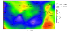
Bouguer gravity anomaly and geological superposition map of the study area
|
|
Geochemical magnetic anomaly and geological superposition map of the study area
|
|
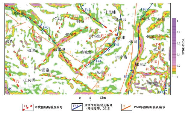
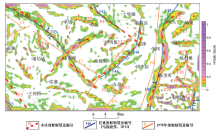
Superposition of gravity anomaly NVDR-THDR and fault detectio of the study area
|
|
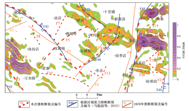
Superposition of chemical polar magnetic anomaly NVDR-THDR and fault detection of the study area
|
| 断裂编号 | 断裂名称 | 断裂特征 | | F1 | 寒冻—殷围
孜断裂 | 该断裂位于研究区西部,沿寒冻—殷围孜—汝南埠一线展布,整体走向NW,其间在汝南埠附近被F5断裂错断。F1断裂位于重力异常梯度带上。F1断裂东北侧为陈店异常高区。在重力异常NVDRTHDR图上显示为断裂与信号的极大值有明显的对应关系 | | F2 | 涧头—张里
店断裂 | 该断裂位于研究区东部,沿涧头—张里店一线展布,呈S形贯穿工作区南北,该断层为正断层,是研究区内的主要断裂构造之一。F2断裂位于重力异常梯度带上,东侧为练村—防胡店异常高区;在重(磁)力异常NVDR-THDR图上显示为断裂与信号的极大值有明显的对应关系 | | F3 | 王勿桥断裂 | 该断裂位于研究区的西南角,位于王勿桥西南,走向NW,该断裂为研究区主要断裂之一, F3断裂位于重力异常梯度带上 | | F4 | 砖店—关津
断裂 | 该断裂位于研究区的北部,沿砖店—关津一线展布,走向NW,该断裂为研究区内的主要断裂之一。F4断裂位于重力异常梯度带上,西南侧为陈店异常高区;在重(磁)力异常NVDR-THDR图上显示为断裂与信号的极大值有明显的对应关系 | | F5 | 佛阁寺—雷
寨断裂 | 该断裂位于研究区的中部,沿佛阁寺—汝南埠—雷寨一线展布,走向近EN,该断裂为研究区内的主要断裂之一,为本次研究发现的新断裂。F5断裂形成时期较F1断裂晚,在后期构造运动中,将F1断裂错断。F5断裂位于重力异常梯度带上,西北侧为陈店异常高区;在重力异常NVDR-THDR图上显示为断裂与信号的极大值有明显的对应关系 | | F6 | 关津断裂 | 该断裂位于研究区中部,走向NE,在关津附近,断裂走向发生改变,向正北方向延伸,该断裂为研究区内的主要断裂之一。F6断裂位于重力异常梯度带上,西北侧为陈店异常高区,与F5断裂基本平行;在重(磁)力异常NVDR-THDR图上显示为断裂与信号的极大值有明显的对应关系 |
|
Analysis of main fracture characteristics in the study area
|
|
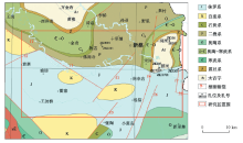
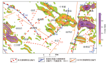
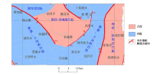
Geological map of bedrock revised this time
|
|
Schematic diagram of inversion profile location
|

|
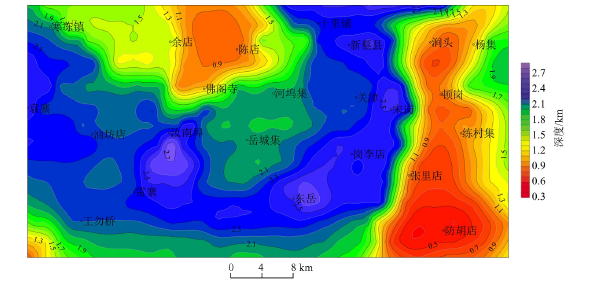
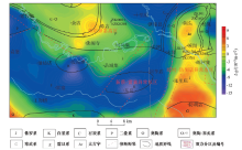
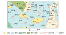
Inferred bathymetric map of Neoarchaean dome
|
|
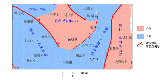
Distribution of basement bulges and depressions by predecessors (MA Zhenbo et al., 2013)
|

|
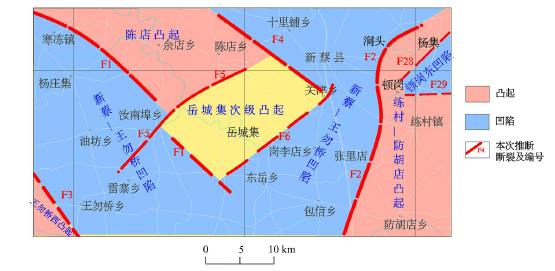
distribution of basement bulge and depression
|
| [1] |
罗明强. 河南省舞阳铁矿地质特征与找矿靶区[J]. 西部探矿工程, 2009,21(12):128-130.
|
| [1] |
Luo M Q. Geological characteristics and prospecting target area in Wuyang iron mine of Henan[J]. West-China Exploration Engineering, 2009,21(12):128-130.
|
| [2] |
韩长寿. 河南省舞阳铁矿深部找矿前景分析[J]. 矿产与地质, 2010,24(2):56-60.
|
| [2] |
Han C S. Analysis of the esploration perpective in the depth of Wuyang iron deposit, Henan province[J]. Mineral Resources and Geology, 2010,24(2):56-60.
|
| [3] |
吕文献, 别建芳, 马洪勇, 等. 河南省新蔡县练村北部铁矿勘查[C]// 河南:中国地质科技新进展和地质找矿新成果资料汇编, 2009.
|
| [3] |
Luy W X, Bie J F, Ma H Y, et al. The exploration of the northern Liancun iron ore of Xincai County in Henan Province[C]// Henan: New progress of geological science and technology and compilation of new achievements in geological prospecting in China, 2009.
|
| [4] |
刘小照, 李国勇, 吴清杰. 河南省新蔡县葛寨铁矿床地质特征、矿床成因及找矿方向[J]. 黑龙江科技信息, 2012(1):36-37.
|
| [4] |
Liu X Z, Li G Y, Wu Q J. Geological characteristics, genesis and prospecting direction of Xincai Gezhai iron deposit in Henan Province[J]. Heilongjiang Science and Technology Information, 2012(1):36-37.
|
| [5] |
涂恩照, 戴帅军, 王夏. 河南新蔡练村铁矿地球化学特征及成因研究[J]. 矿产勘查, 2018,5(5):887-893.
|
| [5] |
Tu E Z, Dai S J, Wang X. Reseaching to the geochemical characteristics and genesis ore deposits of the Xincai Liancun iron deposit in Henan[J]. Mineral Exploration, 2018,5(5):887-893.
|
| [6] |
杨崇科, 卢欣祥, 杨延伟, 等. 河南新蔡练村铁矿床地质特征与成矿构造背景[J]. 矿产与地质, 2018,32(6):64-71.
|
| [6] |
Yang C K, Lu X X, Yang Y W, et al. Geological characteristics and metallogenic tectonic back-ground of Xincai Liancun iron deposit in Henan Provinc[J]. Mineral Resources and Geology, 2018,32(6):64-71.
|
| [7] |
马振波, 陈天振, 曹清章, 等. 河南漯河-信阳地区1∶25万区域重力调查报告[R]. 天津:中国地质调查局天津地质调查中心, 2013.
|
| [7] |
Ma Z B, Chen T Z, Cao Q Z, et al. 1∶250000 Regional gravity survey report in Luohe Xinyang area of Henan Province[R]. Tianjin: Tianjin Center, China Geological Survey, 2013.
|
| [8] |
张磊, 马振波, 陈天振, 等. 河南舞阳新蔡铁矿整装勘查区1∶5万区域地质综合调查成果报告[R]. 天津:中国地质调查局天津地质调查中心, 2016.
|
| [8] |
Zhang L, Ma Z B, Chen T Z, et al. Report on the comprehensive investigation results of 1∶50000 regional geology in Wuyang Xincai iron ore exploration area of Henan Province[R]. Tianjin: Tianjin Center, China Geological Survey, 2016.
|
| [9] |
王万银, 邱之云, 杨永, 等. 位场边缘识别方法研究进展[J]. 地球物理学进展, 2010,25(1):196-210.
|
| [9] |
Wang W Y, Qiu Z Y, Yang Y, et al. Some advances in the edge recognition of the potential field[J]. Progress in Geophysics, 2010,25(1):196-210.
|
| [10] |
王万银. 位场总水平导数极值位置空间变化规律研究[J]. 地球物理学报, 2010,53(9):2257-2270.
|
| [10] |
Wang W Y. Spatial variation law of the extreme value positions of total horizontal derivative for potential field data[J]. Chinese Journal of Geophysics, 2010,53(9):2257-2270.
|
| [11] |
柏冠军, 吴汉宁, 赵希刚, 等. 重力资料识别鄂尔多斯盆地线性构造方法研究[J]. 地球物理学进展, 2007,22(5):1386-1392.
|
| [11] |
Bo G J, Wu H N, Zhao X G, et al. Research on recognition of linear structures using gravity data in ordos basin[J]. Progress in Geophysics, 2007,22(5):1386-1392.
|
| [12] |
钟清, 孟小红, 刘士毅. 重力资料定位地质体边界问题的探讨[J]. 物探化探计算技术, 2007,29(s):35-38.
|
| [12] |
Zhong Q, Meng X H, Liu S Y. Study on the geological body `s edge detection of using gravity data[J]. Computing Techniques for Geophysical and Geochemical Exploration, 2007,29(Suppl):35-38.
|
| [13] |
孙鹏飞, 吴燕冈. 利用重磁水平和垂直二阶导数确定东北地区梯度带[J]. 吉林大学学报:地球科学版, 2007,37(s):27-31.
|
| [13] |
Sun P F, Wu Y G. Make use of vertically and horizontal differential coefficient of the gravitation and magnetic force to ensure the grads of the northeast China[J]. Journal of Jilin University:Earth Science Edition, 2007,37(Suppl):27-31.
|
| [14] |
刘金兰, 李庆春, 赵斌. 位场场源边界识别新技术及其在山西古构造带与断裂探测中的应用研究[J]. 工程地质学报, 2007,15(4):569-574.
|
| [14] |
Liu J L, Li Q C, Zhao B. New detection techniques of geologic boundaries using potential-field data and its application in the Shanxi paleo-structure zone and faults[J]. Journal of Engineering Geology, 2007,15(4):569-574.
|
| [15] |
黄临平, 管志宁. 利用磁异常总梯度模确定磁源边界位置[J]. 华东地质学院学报, 1998,21(2):143-150.
|
| [15] |
Huang L P, Guan Z N. Determining the boundary position of magnetic source by using the total gradient model of magnetic anomaly[J]. Journal of East China Geological Institute, 1998,21(2):143-150.
|
| [16] |
梁建, 线纪安, 郭玉峰. 总梯度模方法在低纬度地区航磁资料解释中的应用[J]. 地质找矿论丛, 2016,31(4):570-575.
|
| [16] |
Liang J, Xian J A, Guo Y F. Applications of the total gradient module to explanation of aero-magnetic data in low latitude[J]. Contributions to Geology and Mineral Resources Research, 2016,31(4):570-575.
|
| [17] |
Wang W Y, Pan Y, Qiu Z Y. A new edge recognition technology based on the normalized verivative of the total horizontal derivative for potential field data[J]. Applied Geophysics, 2009,6(3):226-233.
|
| [18] |
吴凌根, 王万银, 李建国, 等. 利用重、磁资料研究五台—恒山地区构造格局[J]. 地球物理学进展, 2015,30(2):531-539.
|
| [18] |
Wu L G, Wang W Y, Li J G, et al. Tectonic framework of Wutaishan-Hengshan region interpreted from gravity and magnetic data[J]. Progress in Geophysics, 2015,30(2):531-539.
|
| [19] |
张科, 方勇, 陈全红, 等. 贝克盆地卫星重力场特征与构造单元划分[J]. 西安科技大学学报, 2018,38(1):145-149.
|
| [19] |
Zhang K, Fang Y, Chen Q H, et al. Satellite gravity field and the division of tectonic units of the Biak Basin,Indonesia[J]. Journal of Xi’an University of Science and Technolog, 2018,38(1):145-149.
|
| [20] |
郑国磊, 徐新学, 李世斌, 等. 天津市重力数据反演解释[J]. 吉林大学学报:地球科学版, 2018,48(4):284-293.
|
| [20] |
Zheng G L, Xu X X, Li S B, et al. Inversion of gravity data in Tianjin[J]. Journal of Jilin University: Earth Science Edition, 2018,48(4):284-293.
|
| [21] |
王万银, 张瑾爱, 刘莹, 等. 利用重磁资料研究莺-琼盆地构造分界及其两侧断裂特征[J]. 地球物理学进展, 2013,28(3):1575-1583.
|
| [21] |
Wang W Y, Zhang J A, Liu Y, et al. Research on the tectonic boundary of Ying-Qiong basin and adjacent faults’ features based on gravity and magnetic data[J]. Progress in Geophysics, 2013,28(3):1575-1583.
|
| [22] |
罗新刚, 王万银, 张功成, 等. 基于重力资料的南海及邻区断裂分布特征研究[J]. 地球物理学报, 2018,61(10):4255-4268.
|
| [22] |
Luo X G, Wang W Y, Zhang G C, et al. Study on distribution features of faults based on gravity data in the South China Sea and its adjacent areas[J]. Chinese Journal of Geophysics, 2018,61(10):4255-4268.
|
| [1] |
MENG Jun-Hai, MA Long, WANG Jin-Hai, ZHAO Li-Ping, WANG Li-Jun, FU Qiang, TONG Ming-Hui. The development and application of gravity data in regional comprehensive interpretation of Delingha region[J]. Geophysical and Geochemical Exploration, 2021, 45(2): 369-378. |
| [2] |
Xue-Fa WANG, Wan-Yin WANG, Jie MA, Min YANG, Jian-She LIANG, Chun-Guang QIU, Ding-Ding WANG, Xiao-Lin JI, Jin-Lan LIU. A study of the distribution characteristics of basin tectonic units based on gravity data in Madagascar and its adjacent basins[J]. Geophysical and Geochemical Exploration, 2020, 44(4): 928-937. |
|
|
|
|