|
|
|
| Multiple gravity and magnetic potential field edge detection methods and their application to the boundary of fault structures in northern South Yellow Sea |
Wen-Qiang XU1,2( ), Bing-Qiang YUAN3, Bi-Liang LIU4, Chang-Li YAO1,2 ), Bing-Qiang YUAN3, Bi-Liang LIU4, Chang-Li YAO1,2 |
1. School of Geophysics and Information Technology,China University of Geosciences(Beijing),Beijing 100083,China
2. Key Laboratory of Geo-detection Ministry of Education,China University of Geosciences(Beijing),Beijing 100083,China
3. School of Earth Sciences and Engineering,Xi’an Shiyou University,Xi’an,Shaanxi 710065,China
4. Qinghai Nulear Industry Geology Bureau,Xining 810003,China |
|
|
|
|
Abstract In order to study the contact relationship of geological bodies and the distribution locations and trends of fault structures on the plane in the northern basin of the South Yellow Sea and its adjacent areas, the authors studied the related means used to solve the related geological structures in the study area. The principles of multiple gravity and magnetic potential field boundary detection methods were systematically analyzed, and the gravity data was processed by various methods in the study area. The fault structure was re-identified and re-extracted to study the system of faults and analyze the characteristics of faults, and the tectonic zoning was conducted in combination with seismic data and related geological recognition in the study area. The results indicate that the joint NVDR-Theta, normalized standard deviations and NVDR-THDR, based on the traditional processing methods, are effective methods for dividing faults. The planar characteristics and depth information of the faults can be more quickly, effectively and accurately reflected by the methods in the study area. NE (NNE)-, NW-, nearly EW- and nearly SN-trending fault structures are developed in the study area, which are hierarchical, regional, and different in activity. The NE (NNE)-trending faults form the main structural framework of the area are the main tectonic bodies of the study area. Under the action of long-term severe activity, NE (NNE)-trending faults are distributed throughout the fault area, and are mainly spread in the northern basin and the northwestern area outside the basin, while nearly EW-trending faults are mainly distributed in the central uplift area. The structure and stratigraphic distribution of the foreland basin were formed in the northern basin under the special tectonic stress environment. Six tectonic zones were recognized in combination with the gravity anomalies and seismic data in the study area, which include Luxi uplift, Jiaolai basin, Jiaonan uplift, Qianliyan uplift, the northern basin of the South Yellow Sea, and the central uplift of the South Yellow Sea.
|
|
Received: 03 February 2020
Published: 28 August 2020
|
|
|
|
|
|
26]
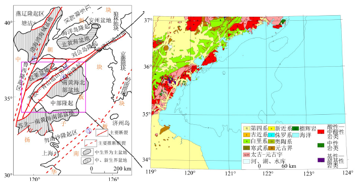
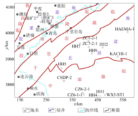
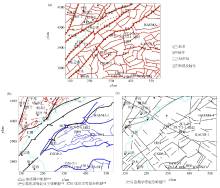
①—Tancheng-Lujiang fault belt;②—Wulian-Qingdao-Rongcheng fault belt;③—Qianliyan fault belt;④—Jiashan-Xiangshui fault belt;⑤—Jiangshan-Shaoxing fault belt
">
|
Sketch map of the tectonic location of the northern basin of the South Yellow Sea and its adjacent areas[26]
①—Tancheng-Lujiang fault belt;②—Wulian-Qingdao-Rongcheng fault belt;③—Qianliyan fault belt;④—Jiashan-Xiangshui fault belt;⑤—Jiangshan-Shaoxing fault belt
|

|
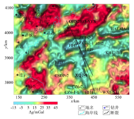
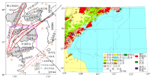
The map of Bouguer gravity anomaly in the northern basin of the South Yellow Sea and its adjacent areas
|
|
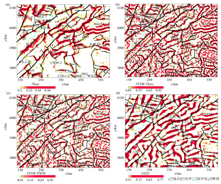
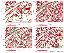
Result maps of approaches of Bouguer gravity anomaly in the northern basin of the South Yellow Sea and its adjacent areas
a—the Theta map of Bouguer gravity anomaly;b—the NVDR-Theta of of Bouguer gravity anomaly;c—the NVDR-THDR of Bouguer gravity anomaly;d—the NSTD of Bouguer gravity anomaly
|
12,26,29,40]
">
|
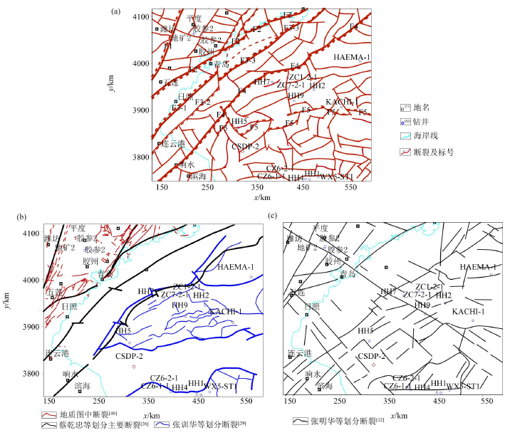
Determined fault (a) and the results of previous studies (b)&(c)[12,26,29,40]
|
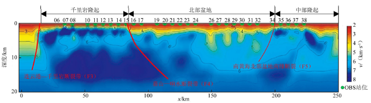
36])
">

|
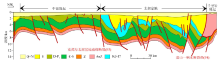
The seismic velocity inversion profile of OBS2013-SYS line in the South Yellow Sea Basin(Modified from Wu et al [36])
|
29])
">
|
Seismic geological interpretation profile (modified from ZhangXunhua[29])
|

|
Tectonic division of the study area
|
| [1] |
王万银, 邱之云, 杨永, 等. 位场边缘识别方法研究进展[J]. 地球物理学进展, 2010,25(1):196-210.
|
| [1] |
Wang W Y, Qiu Z Y, Yang Y, et al. Some advances in the edge recognition of the potential field[J]. Progress in Geophysics, 2010,25(1):196-210.
|
| [2] |
王万银. 位场总水平导数极值位置空间变化规律研究[J]. 地球物理学报, 2010,53(9):2257-2270.
|
| [2] |
Wang W Y. Spatial variation law of the extreme value positions of total horizontal derivative for potential field data[J]. Chinese J.Geophys., 2010,53(9):2257-2270.
|
| [3] |
陈青, 袁炳强, 董云鹏, 等. 断裂识别新方法及其在肯尼亚Tana凹陷中的应用[J]. 西北大学学报:自然科学版, 2013,43(4):599-605.
|
| [3] |
Chen Q, Yuan B Q, Dong Y P, et al. The new methods to study fault structure by gravity data and applications to TANA sag in Kenya[J]. Journal of Northwest University:Natural Science Edition, 2013,43(4):599-605.
|
| [4] |
刘金兰, 李庆春, 赵斌. 位场场源边界识别新技术及其在山西古构造带与断裂探测中的应用研究[J]. 工程地质学报, 2007,15(4):569-574.
|
| [4] |
Liu J L, Li Q C, Zhao B. New detection techniques of geologic boundaries using potential-field data and its application in the Shanxi Paleo-structure zone and faults[J]. Journal of Engineering Geology, 2007,15(4):569-574.
|
| [5] |
王彦国. 位场数据处理的高精度方法研究及应用[D]. 长春:吉林大学, 2013.
|
| [5] |
Wang Y G. Study and application of high-precision methods in potential-field data processing[D]. Changchun:Jilin University, 2013.
|
| [6] |
陈安国, 周涛发, 刘东甲, 等. 基于Theta法改进的均衡滤波器在位场边界识别中的应用——以庐枞矿集区为例[J]. 地球物理学报, 2017,60(2):778-792.
|
| [6] |
Chen A G, Zhou T F, Liu D J, et al. Application of the improved filter based on the Theta method to edge detection of potential field data: an example from the Luzong ore district[J]. Chinese J. Geophys., 2017,60(2):778-792.
|
| [7] |
刘光鼎. 中国海区及邻域地质地球物理特征[M]. 北京: 科学出版社, 1992a.
|
| [7] |
Liu G D. Geologic-Geophysic features of China seas and adjacent regions[M]. Beijing: Science Press, 1992a.
|
| [8] |
陈清华, 宋若薇, 戴俊生, 等. 胶莱盆地重磁资料解释与构造特征分析[J]. 地球物理学进展, 1994,9(3):70-79.
|
| [8] |
Chen Q H, Sun R W, Dai J S, et al. Jiaolai basin gravity and magnetic data interpretation and structure analysis[J]. Progress in Geophysics, 1994,9(3):70-79.
|
| [9] |
马兆同, 刘辉勤, 马兆祥. 胶南造山带及邻近地区的重磁场特征及地质解释[J]. 山东地质, 1997,13(1):92-102.
|
| [9] |
Ma Z T, Liu H Q, Ma Z X. Features of gravity and magnetic fields and geological explanation of the Jiaonan orogenic belt and its neighbour areas[J]. Shandong Geology, 1997,13(1):92-102.
|
| [10] |
Liang R C, Pei Y L, Zheng Y P. Gravity and magnetic field and tectonic structure character in the southern Yellow Sea[J]. Chinese Science Bulletin, 2003,48(s):64-73.
|
| [11] |
戴勤奋, 周良勇, 魏合龙. 南黄海卫星重力场及构造演化[J]. 海洋地质与第四纪地质, 2002,22(4):67-72.
|
| [11] |
Dai Q F, Zhou L Y, Wei H L. Satellite gravity field and tectonic evolution of the South Yellow Sea[J]. Marine Geology & Quaternary Geology, 2002,22(4):67-72.
|
| [12] |
Zhang M H, Xu D S, Chen J W. Geological structure of the yellow sea area from regional gravity and magnetic interpretation[J]. Applied Geophysics, 2007,4(2):75-83.
|
| [13] |
郝天珧, 黄松, 徐亚, 等. 关于黄海深部构造的地球物理认识[J]. 地球物理学报, 2010,53(6):1315-1326.
|
| [13] |
Hao T Y, Huang S, Xu Y, et al. Geophysical understandings on deep structure in Yellow Sea[J]. Chinese J.Geophys., 2010,53(6):1315-1326.
|
| [14] |
姚长利. 黄海及周边地区重磁震综合反演技术研究及重磁资料处理解释[R]. 北京:中国地质大学(北京), 2005.
|
| [14] |
Yao C L. Research of gravity-magnetic-seismic integrated inversion technology and processing&interpretation of gravity and magnetic data in the Yellow Sea and adjacent regions[R]. Beijing:China University of Geosciences(Beijing), 2005.
|
| [15] |
袁炳强. 南黄海海域多元信息综合解释研究[R]. 西安:西安石油大学, 2015.
|
| [15] |
Yuan B Q. Study of comprehensive interpretation of multivariate information in the South Yellow Sea[R]. Xi’an:Xi’an Shiyou University, 2015.
|
| [16] |
谢天峰. 南黄海重磁资料处理与断裂系统研究[D]. 北京:中国科学院研究生院, 2008.
|
| [16] |
Xie T F. Processing on gravity and magnetic data of South Yellow Sea and research on fracture system[D]. Beijing:Graduate School of Chinese Academy of Sciences, 2008.
|
| [17] |
杨慧良. 南通幅区域地球物理场特征研究[D]. 北京:中国科学院研究生院, 2009.
|
| [17] |
Yang H L. Study on the characteristics of regional geophysical field in Nantong area[D]. Beijing:Graduate School of Chinese Academy of Sciences, 2009.
|
| [18] |
骆迪, 张训华, 蔡峰, 等. 重磁震联合反演及综合解释在海域构造解释中的应用[J]. 海洋地质与第四纪地质, 2014,34(6):135-143.
|
| [18] |
Luo D, Zhang X H, Cai F, et al. Integrated gravity-magnetic-seismic data inversion and interpretation and their application to underwater tectonics[J]. Marine Geology & Quaternary Geology, 2014,34(6):135-143.
|
| [19] |
张婉, 张玄杰, 佟晶, 等. 日照—连云港地区重磁异常特征及其构造意义[J]. 地球科学, 2018,43(12):4490-4497.
|
| [19] |
Zhang W, Zhang X J, Tong J, et al. Gravity and magnetic anomaly characteristics and its geological interpretation in Rizhao and Lianyungang areas[J]. Earth Science, 2018,43(12):4490-4497.
|
| [20] |
Wijns C, Perez C, Kowalczyk P. Theta map:Edge detection in magnetic data[J]. Geophysics, 2005,70(4):L39-L43.
|
| [21] |
何涛, 王万银, 黄金明, 等. 正则化方法在比值类位场边缘识别方法中的研究[J]. 物探与化探, 2019,43(2):308-319.
|
| [21] |
He T, Wang W Y, Huang J M, et al. The research of the regularization method in the ratio methods of edge recognition by potential field[J]. Geophysical and Geochemical Exploration, 2019,43(2):308-319.
|
| [22] |
王万银. 位场边缘识别方法技术研究[D]. 西安:长安大学, 2009.
|
| [22] |
Wang W Y. The Research on the edge recognition methods and techniques for potential field[D]. Xi’an:Chang’an University, 2009.
|
| [23] |
Cooper G R J, Cowan D R. Edge enhancement of potential-field data using normalized statistics[J]. Geophysics, 2008,73(3):H1-H4.
|
| [24] |
Wang W Y, Pan Y, Qiu Z Y. A new edge recognition technology based on the normalized vertical derivative of the total horizontal derivative for potential field data[J]. Applied Geophysics, 2009,6(3):226-233.
|
| [25] |
汪龙文. 南黄海的基本地质构造特征和油气远景[J]. 海洋地质与第四纪地质, 1989,9(3):41-50.
|
| [25] |
Wang L W. Basic characteristics of geology and prospects of oil and gas production in the Southern Huanghai Sea basin[J]. Marine Geology & Quaternary Geology, 1989,9(3):41-50.
|
| [26] |
蔡乾忠. 中国海域油气地质学[M]. 北京: 海洋出版社, 2005.
|
| [26] |
Cai Q Z. Oil&Gas geology in China seas[M]. Beijing: China Ocean Press, 2005.
|
| [27] |
李家彪. 中国区域海洋学—海洋地质学[M]. 北京: 海洋出版社, 2012.
|
| [27] |
Li J B. Regional oceanography of China seas-marine geology[M]. Beijing: China Ocean Press, 2012.
|
| [28] |
袁勇, 陈建文, 张银国, 等. 南黄海盆地崂山隆起海相中—古生界构造地质特征[D]. 海洋地质前沿, 2016,32(1):48-53.
|
| [28] |
Yuan Y, Chen J W, Zhang Y G, et al. Geotectonic features of the marine Mesozoic-Paleozoic on The Laoshan Uplift of the South Yellow Sea basin[J]. Marine Geology Frontiers, 2016,32(1):48-53.
|
| [29] |
张训华, 肖国林, 吴志强, 等. 南黄海油气勘探若干地质问题认识和探讨——南黄海中—古生界海相油气勘探新进展与面临的挑战[M]. 北京: 科学出版社, 2017.
|
| [29] |
Zhang X H, Xiao G L, Wu Z Q, et al. Recognition and discussion of several geological problems in oil&gas exploration of the South Yellow Sea-New progress and challenges in the Mesozoic-Paleozoic marine oil&gas exploration of the South Yellow Sea[M]. Beijing: Science Press, 2017.
|
| [30] |
王万银, 刘金兰, 邱之云, 等. 利用卫星重力异常研究南黄海地区中生界厚度[J]. 中国海上油气, 2004,16(3):151-156,169.
|
| [30] |
Wang W Y, Liu J L, Qiu Z Y, et al. A research on Mesozoic thickness using satellite gravity anomaly in the southern Yellow Sea[J]. China Offshore Oil and Gas, 2004,16(3):151-156,169.
|
| [31] |
张鹏, 王良书, 钟锴, 等. 郯庐断裂带的分段性研究[J]. 地质论评, 2007,53(5):586-591.
|
| [31] |
Zhang P, Wang L S, Zhong K, et al. Research on the Segmentation of Tancheng-Lujiang Fault Zone[J]. Geological Review, 2007,53(5):586-591.
|
| [32] |
宋明春, 王沛成. 山东省区域地质[M]. 济南: 山东省地图出版社, 2003.
|
| [32] |
Song M C, Wang P C. Regional geology of Shandong province[M]. Jinan: Shandong Map Publishing House, 2003.
|
| [33] |
李洪奎, 陈国栋, 梁太涛, 等. 沂沭断裂带构造活动与胶东金矿形成关系之探讨[J]. 山东国土资源, 2017,33(11):6-14.
|
| [33] |
Li H K, Chen G D, Liang T T, et al. Study on the relationship between tectonic activity in Yishu fault zone and the formation of gold deposits in Jiaodong area[J]. Shandong Land and Resources, 2017,33(11):6-14.
|
| [34] |
杨文采, 徐纪人, 程振炎, 等. 苏鲁大别造山带地球物理与壳幔作用[M]. 北京: 地质出版社, 2005.
|
| [34] |
Yang W C, Xu J R, Cheng Z Y, et al. Regional geophysics and crust-Mantle interacton in Sulu-Dabie orogenic belt[M]. Beijing: Geological Publishing House, 2005.
|
| [35] |
马寅生, 崔盛芹, 施炜, 等. 中国东部、朝鲜半岛海陆构造格局及含油气盆地特征[M]. 北京: 地质出版社, 2007.
|
| [35] |
Ma Y S, Cui S Q, Shi W, et al. The characteristics of petroleum basins and structure of the sea and land in eastern China and the Korean peninsula[M]. Beijing: Geological Publishing House, 2007.
|
| [36] |
吴志强, 刘丽华, 肖国林, 等. 南黄海海相残留盆地综合地球物理调查进展与启示[J]. 地球物理学进展, 2015,30(6):2945-2954.
|
| [36] |
Wu Z Q, Liu L H, Xiao G L, et al. Progress and enlightenment of integrated geophysics exploration of marine residual basin in the South Yellow Sea[J]. Progress in Geophysics, 2015,30(6):2945-2954.
|
| [37] |
许东禹, 刘锡清, 张训华, 等. 中国近海地质[M]. 北京: 地质出版社, 1997.
|
| [37] |
Xu D Y, Liu X Q, Zhang X H, et al. China offshore geology[M]. Beijing: Geological Publishing House, 1997.
|
| [38] |
赵志新, 徐纪人. 广角反射地震探测得到的中国东部地壳三维P波速度结构[J]. 科学通报, 2009,54(7):931-937.
|
| [38] |
Zhao Z X, Xu J R. Three-dimensional crustal velocity structure of P-wave in East China from wide-angle reflection and refraction surveys[J]. Chinese Sci. Bull., 2009,54(8):1389-1397.
|
| [39] |
魏文博, 叶高峰, 金胜, 等. 华北地区东部岩石圈导电性结构研究——减薄的华北岩石圈特点[J]. 地学前缘, 2008,15(4):204-215.
|
| [39] |
Wei W B, Ye G F, Jin S, et al. Geoelectric structure of lithosphere beneath eastern North China: features of a thinned lithosphere from magnetotelluric soundings[J]. Earth Science Frontiers, 2008,15(4):204-216.
|
| [40] |
马丽芳. 中国地质图集(山东省地质图&江苏省地质图)[M]. 北京: 地质出版社, 2002.
|
| [40] |
Ma L F. Geological atlas of China(Shandong Geological Map & Jiangsu Geological Map) [M]. Beijing: Geological Publishing House, 2002.
|
| [41] |
杨长清, 董贺平, 李刚. 南黄海盆地中部隆起的形成与演化[J]. 海洋地质前沿, 2014,30(7):17-21,33.
|
| [41] |
Yang C Q, Dong H P, Li G. Formation and tectonic evolution of the Central Uplift of the South Yellow Sea basin[J]. Marine Geology Frontiers, 2014,30(7):17-21,33.
|
| [42] |
姚永坚, 冯志强, 郝天珧, 等. 对南黄海盆地构造层特征及含油气性的新认识[J]. 地学前缘, 2008,15(6):232-240.
|
| [42] |
Yao Y J, Feng Z Q, Hao T Y, et al. A new understanding of the structural layers in the South Yellow Sea basin and their hydrocarbon-bearing characteristics[J]. Earth Science Frontiers, 2008,15(6):232-240.
|
| [43] |
冯志强, 陈春峰, 姚永坚, 等. 南黄海北部前陆盆地的构造演化与油气突破[J]. 地学前缘, 2008,15(6):219-231.
|
| [43] |
Feng Z Q, Chen C F, Yao Y J, et al. Tectonic evolution and exploration target of the northern foreland basin of the South Yellow Sea[J]. Earth Science Frontiers, 2008,15(6):219-231.
|
| [44] |
许红, 周瑶琪, 韩宗珠, 等. 南黄海千里岩岛—灵山岛地质特征与油气[M]. 北京: 科学出版社, 2017.
|
| [44] |
Xu H, Zhou Y Q, Han Z Z, et al. Geological characteristics and oil and gas of Qianliyan Island-Lingshan Island in the South Yellow Sea[M]. Beijing: Science Press, 2017.
|
| [45] |
许明, 陈建文, 雷宝华, 等. 南黄海海域中生代前陆盆地形成的构造背景[J]. 现代地质, 2019,33(1):13-24.
|
| [45] |
Xu M, Chen J W, Lei B H, et al. Tectonic background of Mesozoic foreland basin development in the Southern Yellow Sea[J]. Geoscience, 2019,33(1):13-24.
|
|
|
|