|
|
|
| The impact and effect of DEM grid spacing on the accuracy of gravity remote topographic correction |
LI Zhong-Ping1,2( ), DAI Guang-Kai3, ZHANG Mao-Hui4 ), DAI Guang-Kai3, ZHANG Mao-Hui4 |
1. School of Geophysics and space information, China University of Geosciences(Wuhan),Wuhan 430074,China
2. Zhengyuan Geology & Exploration Institute of Shandong,Bureau of China Metallurgy and Geology,Jinan 250014,China
3. Shandong Institute of Geological Survey, Jinan 250013, China
4. School of Geophysics and Space Information, China University of GeosciencesOcean University of China, Qingdao 266100, China |
|
|
|
|
Abstract The 1∶50 000 gravity far area terrain correction is generally obtained from the 1∶50 000 DEM elevation model correction in the survey area. 1∶50 000 DEM can be spliced according to different grid spacings, which correspond to different terrain correction accuracies; RGIS is calculated by its own elevation database, and the topographic correction of 1∶50 000 gravity far area in the survey area is completed. The authors chose the 1∶50 000 gravity remote area I (2~20 km) land reform of Zangjiazhuang area in Qixia City, Shandong Province, as an example. Through the use of 25, 50, 100, 200 m four grid node spacings for 1∶50 000 DEM data splicing and the use of the improved bilinear interpolation method, the authors calculated the terrain correction and mean square error in the far area I of gravity. Compared with the terrain correction mean square error of gravity far area I of RGIS own elevation reservoir, it is confirmed that the terrain correction accuracy of gravity far-Ⅰ area based on 1∶50 000 DEM elevation model is better than that of gravity far-Ⅰ area with RGIS.
|
|
Received: 15 January 2020
Published: 29 December 2020
|
|
|
|
|
|
|
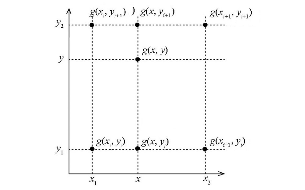
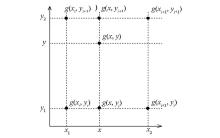
Bilinear Interpolation Graphics
|
|
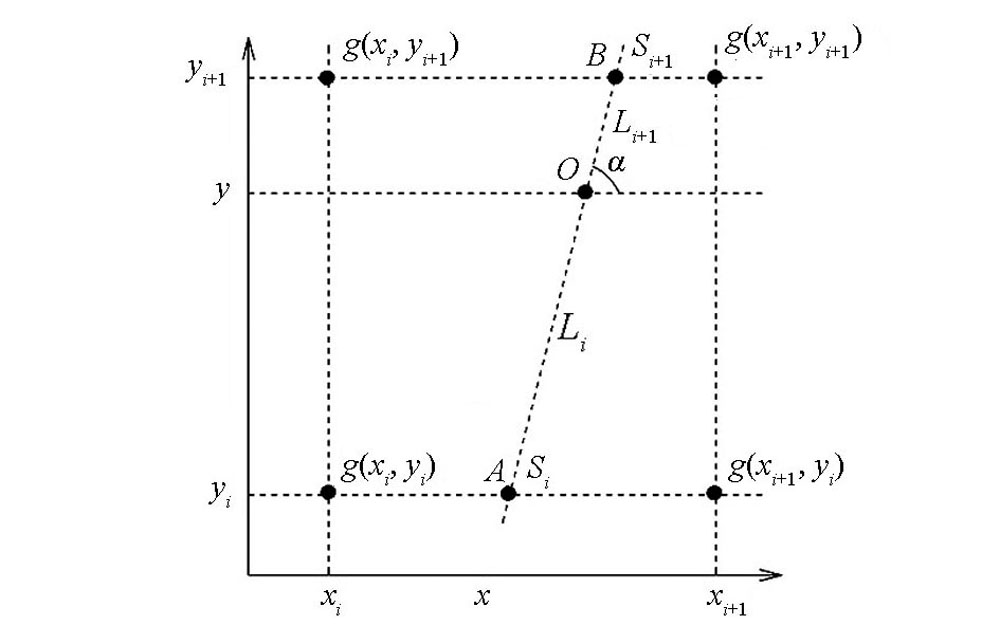
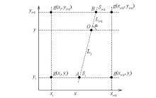
Improved bilinear interpolation method
|
|
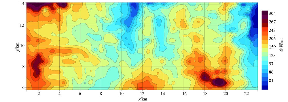
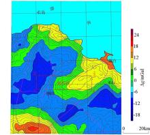
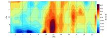
Plane of Bouguer gravity anomaly in the Yantai area of Shandong Province
|

| 节点 | x坐标/m | y坐标/m | | g(xi,yi)=-11.15 | 302130 | 4136486 | | g(xi,yi+1)=-11.58 | 302130 | 4137983 | | g(xi+1,yi)=-8.03 | 305036 | 4136486 | | g(xi+1,yi+1)=-9.03 | 305036 | 4137983 | | 双线性插值法地改后布格重力异常值 | -9.55×10⁻⁵m·s-2 | | 改进的双线性插值法地改后布格重力异常值 | -10.69×10⁻⁵m·s-2 |
|
Comparison table of test calculation of improved bilinear interpolation method
|
| 节点距 | 重力远Ⅰ区地改时间 | 重力远Ⅰ区地改均方误差 | | 25 m×25 m | 1.52 h | 0.000 360 | | 50 m×50 m | 15 min | 0.000 360 | | 100 m×100 m | 6 min | 0.000 385 | | 200 m×200 m | 4 min | 0.000 408 |
|
Statistical table of terrain correction accuracy in distant I area of gravity with different mesh spacing
|

|
Topographic map of the study area
|
|
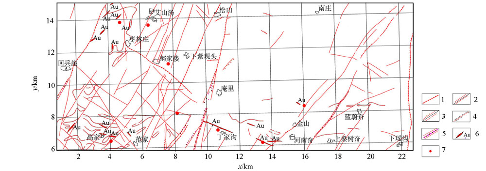
Structure of the study area and Titanium Vein
1—speculated fracture; 2—compression torsion fracture; 3—tensile fracture; 4—ductile fault;5—structural fracture zone; 6—gold vein vein; 7—drilling
|
|
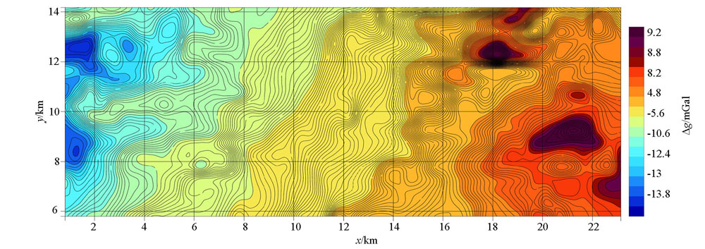
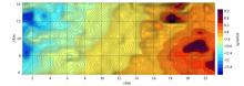
Based on the Bouguer gravity anomaly map of the remote area of RGIS with its own elevation
|
|
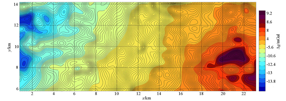
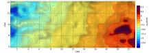
Modified Bouguer gravity anomaly map of far area by bilinear interpolation based on DEM
|

|
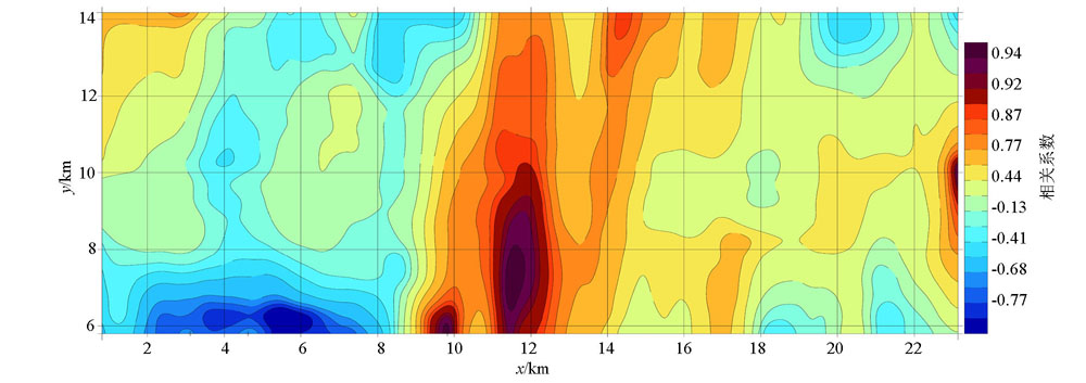
Based on the distribution of elevation kupger gravity anomaly and elevation correlation coefficient in RGIS
|
|
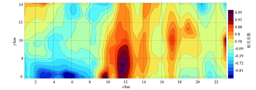
Improved bilinear interpolation kupger gravity anomaly and elevation correlation coefficient distribution based on DEM
|
| [1] |
李东汉. 试论区域重力测量远区地改的精度[J]. 物探与化探, 1984,8(2):99-104.
|
| [1] |
Li D H. Discussion on the accuracy of regional gravity measurement in remote area[J]. Geophysical and Geochemical Exploration, 1984,8(2):99-104.
|
| [2] |
周江存, 徐建桥, 孙和平. 中国大陆精密重力潮汐改正模型[J]. 地球物理学报, 2009,52(6):1474-1482.
|
| [2] |
Zhou J C, Xu J Q, Sun H P. Precise gravity tide correction model in mainland China[J]. Chinese Journal of Geophysics, 2009,52(6):1474-1482.
|
| [3] |
张国利, 赵更新, 匡海阳, 等. 近几年地面重力调查工作方法技术的一些进展[J]. 地球物理学进展, 2015,30(1):386-390.
|
| [3] |
Zhang G L, Zhao G X, Kuang H Y, et al. Some advances in working methods and techniques of ground gravity surveys in recent years[J]. Progress in Geophysics, 2015,30(1):386-390.
|
| [4] |
郑伟, 许厚泽, 钟敏, 等. 基于改进的预处理共轭梯度法和三维插值法精确和快速解算GRACE地球重力场[J]. 地球物理学进展, 2011,26(3):805-812.
|
| [4] |
Zheng W, Xu H Z, Zhong M, et al. Accurate and fast calculation of GRACE Earth’s gravity field based on improved pre-processing conjugate gradient method and 3D interpolation method[J]. Progress in Geophysics, 2011,26(3):805-812.
|
| [5] |
徐璐平, 张贵宾, 李皎皎, 等. 航空重力地改最大半径的研究及地改快速计算方法比较[J]. 物探与化探, 2015,39(S1):113-118.
|
| [5] |
Xu L P, Zhang G B, Li J J, et al. Research on the Maximum Radius of Aerial Gravity Land Reform and Comparison of Fast Calculation Methods of Land Reform[J]. Geophysical and Geochemical Exploration, 2015,39(S1):113-118.
|
| [6] |
张伟, 廖国忠, 张秋冬, 等. 球坐标系下基于全球DEM数据的重力远二区高精度地改算法[J]. 大地测量与地球动力学, 2015,35(4):632-635.
|
| [6] |
Zhang W, Liao G Z, Zhang Q D, et al. High-precision ground gravity correction algorithm based on global DEM data in spherical coordinates[J]. Geodetics and Geodynamics, 2015,35(4):632-635.
|
| [7] |
宋旭锋, 曹涛, 代达龙, 等. 激光测距仪在大比例尺重力测量近区地改中的应用研究[J]. 云南大学学报:自然科学版, 2012,34(S2):171-174.
|
| [7] |
Song X F, Cao T, Dai D L, et al. Application of laser rangefinder in large scale gravity measurement of near-field ground reform[J]. Journal of Yunnan University: Natural Science Edition, 2012,34(S2):171-174.
|
| [8] |
钟华, 张海玲, 刘和花, 等. 估计重力地改最佳地层密度值的面积相关法[J]. 物探与化探, 2013,37(3):512-516.
|
| [8] |
Zhong H, Zhang H L, Liu H H, et al. Area correlation method for estimating the best stratum density value of gravity ground[J]. Geophysical and Geochemical Exploration, 2013,37(3):512-516.
|
| [9] |
尹文笋, 张建中. 陆地和海底地形对海洋重力异常的影响[J]. 地球物理学进展, 2014,29(5):2449-2455.
|
| [9] |
Yin W S, Zhang J Z. Effects of land and seafloor topography on ocean gravity anomalies[J]. Progress in Geophysics, 2014,29(5):2449-2455.
|
| [10] |
杨再朝. 在笛卡尔坐标系下进行重力全球测量外部改正的快速算法[J]. 石油地球物理勘探, 1988,23(5):630-637,642.
|
| [10] |
Yang Z C. A Fast algorithm for external correction of global gravity survey in cartesian coordinate system[J]. Petroleum Geophysics, 1988,23(5):630-637,642.
|
| [11] |
王旭, 周爱国, 孙自永, 等. 1972~2009年念青唐古拉山西段冰湖分布及其变化特征[J]. 地质科技情报, 2012,31(4):91-97.
|
| [11] |
Wang X, Zhou A G, Sun Z Y, et al. Ice lake distribution and variation characteristics in the western section of gula mountain in Nianqing and Tang dynasty from 1972 to 2009[J]. Geological Science and Technology Information, 2012,31(4):91-97.
|
| [12] |
胡明科, 江玉乐, 李超, 等. 基于面积分的重力地形改正方法研究及应用[J]. 物探化探计算技术, 2015,37(2):182-186.
|
| [12] |
Hu M K, Jiang Y L, Li C, et al. Research and application of gravity terrain correction method based on area division[J]. Computing Technology for Geophysical and Geochemical Exploration, 2015,37(2):182-186.
|
| [13] |
徐璐平. 航空重力地形改正研究及其算法改进[D]. 北京:中国地质大学(北京), 2011.
|
| [13] |
Xu L P. Research on aviation gravity terrain correction and its algorithm improvement[D]. Beijing:China University of Geosciences (Beijing), 2011.
|
| [14] |
宋珊. 三维地球的并行区块化网格生成方法[A]//中国地球物理学会. 中国地球物理 2012, 2012.
|
| [14] |
Song S. Parallelized grid generation method for 3D earth [A]//Chinese Geophysical Society. Chinese Geophysics 2012,2012.
|
| [15] |
杨辉, 丁海涛, 王宜昌, 等. 山区重力改正中几个问题的讨论[J]. 石油地球物理勘探, 2000,35(4):479-486.
|
| [15] |
Yang H, Ding H T, Wang Y C, et al. Discussion on several issues in gravity correction in mountain areas[J]. Petroleum Geophysics, 2000,35(4):479-486.
|
| [16] |
骆迪, 刘展, 李曼, 等. 重力校正中存在的若干问题CJ7. 地球物理学进展, 2013,28(1):111-120.
|
| [16] |
Luo D, Liu Z, Li M, et al. Several problems in gravity correction CJ7[J]. Advances in Geophysics, 2013,28(1):111-120.
|
| [17] |
朱文泉. 在山区试用高精度重力测量普查金属矿[J]. 地球物理学报, 1961,10(1):83-97.
|
| [17] |
Zhu W Q. Trial of high-precision gravity survey of general surveyed metal deposits in mountain areas[J]. Chinese Journal of Geophysics, 1961,10(1):83-97.
|
| [18] |
江为为, 管志宁, 郝天珧, 等. 华北地台北缘地球物理场特征与金属矿床预测[J]. 地球物理学报, 2002,45(2):233-245.
|
| [18] |
Jiang W W, Guan Z N, Hao T Z, et al. The geophysical field features and metal deposits prediction in the Taipei margin of north China[J]. Chinese Journal of Geophysics, 2002,45(2):233-245.
|
| [19] |
张伟, 廖国忠, 张秋冬, 等. 基于三角网扣合的山区重力测量高精度近区地改算法[J]. 地球物理学进展, 2015,30(5):2330-2336.
|
| [19] |
Zhang W, Liao G Z, Zhang Q D, et al. High-precision near-field geo-reformation algorithm for gravity measurement in mountain areas based on triangulation mesh[J]. Progress in Geophysics, 2015,30(5):2330-2336.
|
| [20] |
Saadi N, et al. Integrating data from remote sensing, geology and gravity for geological investigation in the Tarhunah area, Northwest Libya Integrating data from remote sensing, geology and gravity for geological investigation in the Tarhunah area, Northwest Libya[J]. International Journal of Digital Earth, 2008 ( 1):347-366.
|
| [21] |
雷晓东, 胡圣标, 杨全合, 等. 北京南口—孙河断裂带水热系统特征与成因分析[J]. 地球物理学报, 2017,60(5):1838-1850.
|
| [21] |
Lei X D, Hu S B, Yang Q H, et al. Characteristics and genesis of the hydrothermal system in the Nankou-Sunhe fault zone of Beijing[J]. Chinese Journal of Geophysics, 2017,60(5):1838-1850.
|
| [22] |
中华人民共和国国土资源部. 重力调查技术规范(1∶50000)[S]. 中华人民共和国地质矿产行业标准[DZ/T0004-2015], 2015.
|
| [22] |
Ministry of Land and Resources of the People's Republic of China. Gravity survey specifications (1∶50000)[S]. Geology and Mineral Resources Industry Standards of the People’s Republic of China[DZ / T0004-2015], 2015.
|
| [23] |
中华人民共和国国土资源部. 大比例尺重力勘查规范[S]. 中华人民共和国地质矿产行业标准[DZ/T0171-2017], 2016.
|
| [23] |
Ministry of Land and Resources of the People's Republic of China. Specification for large-scale gravity exploration[S]. Geological and Mineral Industry Standard of the People’s Republic of China[DZ / T0171-2017] , 2016.
|
| [24] |
徐遵义, 姜玉祥, 赵亮, 等. 改进的Shepard算法及其在重力异常插值中的应用[J]. 武汉大学学报:信息科学版, 2010,35(4):477-480.
|
| [24] |
Xu Z Y, Jiang Y X, Zhao L, et al. Improved Shepard algorithm and its application in gravity anomaly interpolation[J]. Geomatics and Information Science of Wuhan University, 2010,35(4):477-480.
|
| [25] |
孙章庆, 孙建国, 岳玉波, 等. 基于快速推进迎风双线性插值法的三维地震波走时计算[J]. 地球物理学报, 2015,58(6):2011-2023.
|
| [25] |
Sun Z Q, Sun J G, Yue Y B, et al. Travel time calculation of 3D seismic waves based on fast-advancing upwind bilinear interpolation[J]. Chinese Journal of Geophysics, 2015,58(6):2011-2023.
|
|
|
|