|
|
|
| A study of the distribution of granite detected by gravity and magnetic data in Yinkeng Demonstration Area of Nanling Yudu-Ganxian ore concentration area |
| Jin-Lan LIU1,2,3, Bin ZHAO4, Wan-Yin WANG1,2,3, Jian-Guo LI4, Xin-Peng ZHOU4, Yun-Peng WANG1,2,3 |
1. Gravity & Magnetic Institute of Chang’an University,Xi’an 710054,China;
2. College of Geology Engineering and Geomatics,Chang’an University,Xi’an 710054,China;
3. Key Laboratory of Western China’s Mineral Resources and Geological Engineering,Ministry of Education,Chang’an University,Xi’an 710054,China;
4. Geophysical and Geochemical Exploration Institute of Shanxi Province,Yuncheng 044004,China |
|
|
|
|
Abstract Located in Yinkeng Town, Yududu-Ganxian ore concentration area, east Nanling Mountains, Southeast China, the Yinkeng Demonstration Area has a good prospect of mineralization, where the granite is closely related to mineralization. Therefore, systematic exploration of granite distribution is one of the key problems in deep prospecting. In this paper, the spatial distribution characteristics of regional granite were comprehensively studied by using gravity and magnetic data, combined with physical, geological, electrical and seismic data. Firstly, the planar distribution of six granite masses in this area was studied and deduced, among which Jiangbei rock mass, Changtan rock mass and Gaoshanjiao rock mass are partially concealed, whereas Liumukeng rock mass and the shallow and deep rock masses of Ge’aowei are completely concealed. It is concluded that the rock mass mainly trends in NE and NNE direction. Then, four gravity (or gravity and magnetic) profiles in the study area were used to invert the spatial distribution of granite, which further revealed the spatial distribution characteristics of the above six rock masses. The inferences are consistent with those obtained by plane gravity and magnetic method as well as the results derived from electrical method and seismic profile interpretation.
|
|
Received: 26 September 2018
Published: 10 April 2019
|
|
|
|
|
|
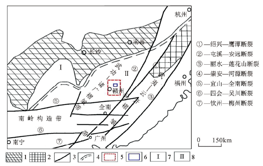
15]
1—Yangtze base uplift; 2—Ccathaysoid base uplift; 3—fault zone and mark; 4—tectonic unit boundary; 5—Yudu-Ganxian ore concentration zone; 6—Yinkeng Demonstration Area; 7—Yangtze Block; 8—South China active belt
">
|
Schematic map of the geotectonics in the Yinkeng Demonstration Area of the Yudu-Ganxian ore concentration zone in the Nanling area[15]
1—Yangtze base uplift; 2—Ccathaysoid base uplift; 3—fault zone and mark; 4—tectonic unit boundary; 5—Yudu-Ganxian ore concentration zone; 6—Yinkeng Demonstration Area; 7—Yangtze Block; 8—South China active belt
|
|
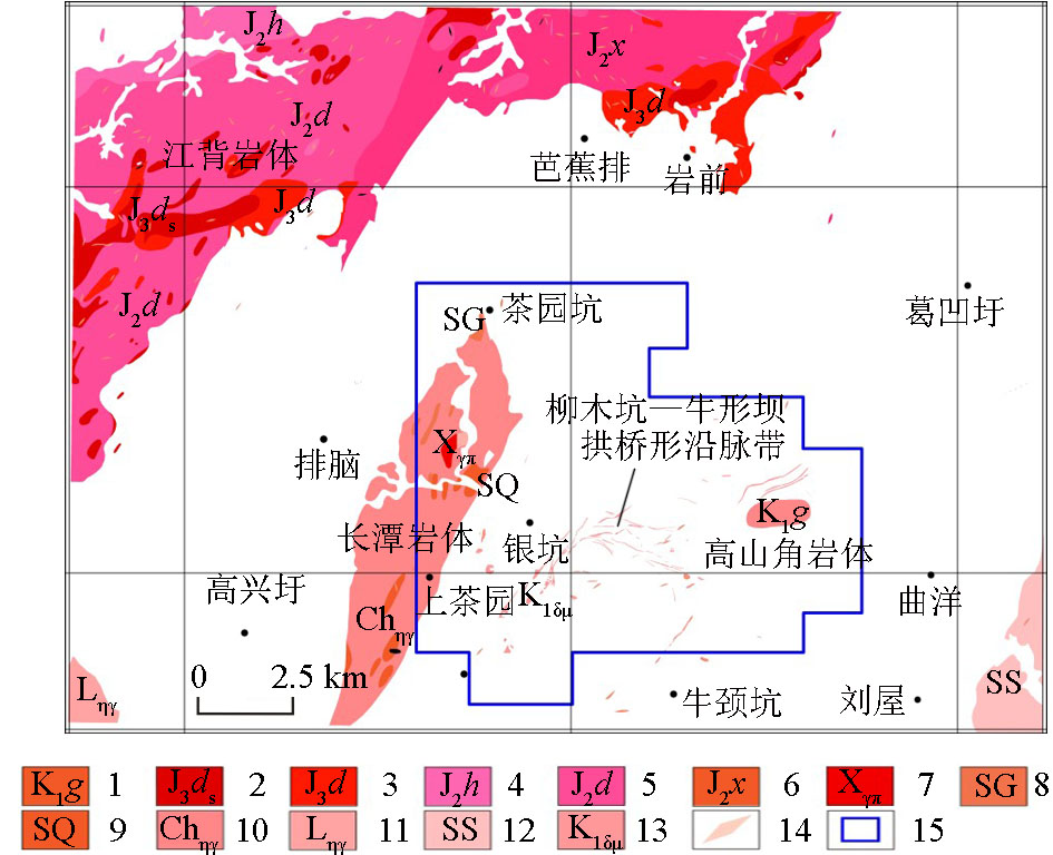
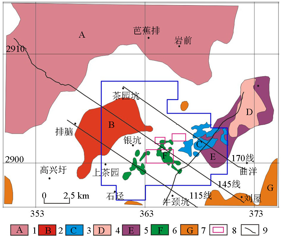
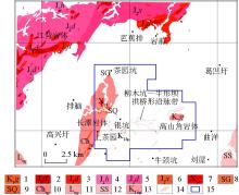
Overall distribution of the exposed rock mass in the Yinkeng Demonstration Area
1—fine-grained porphyritic biotite granodiorite;2—fine-grained monzogranite;3—meso-fine-grained porphyritic biotite monzogranite;4—meso-coarse-grained porphyritic biotite monzogranite;5—meso-grained porphyritic biotite monzogranite;6—meso-grained oligophyric biotite monzogranite;7—granite prophyry;8—fine-grained muscovite monzogranite;9—fine-grained oligophyric tourmalinite monzogranite;10—meso-coarse-grained porphyritic biotite monzogranite;11—muscovitization meso-grained porphyritic monzogranite;12—meso-coarse-grained porphyritic biotite monzogranite;13—diorite porphyrite;14—dikes (granite porphyry, granodiorite porphyry, and quartz porphyry);15—Yinkeng ore field
|
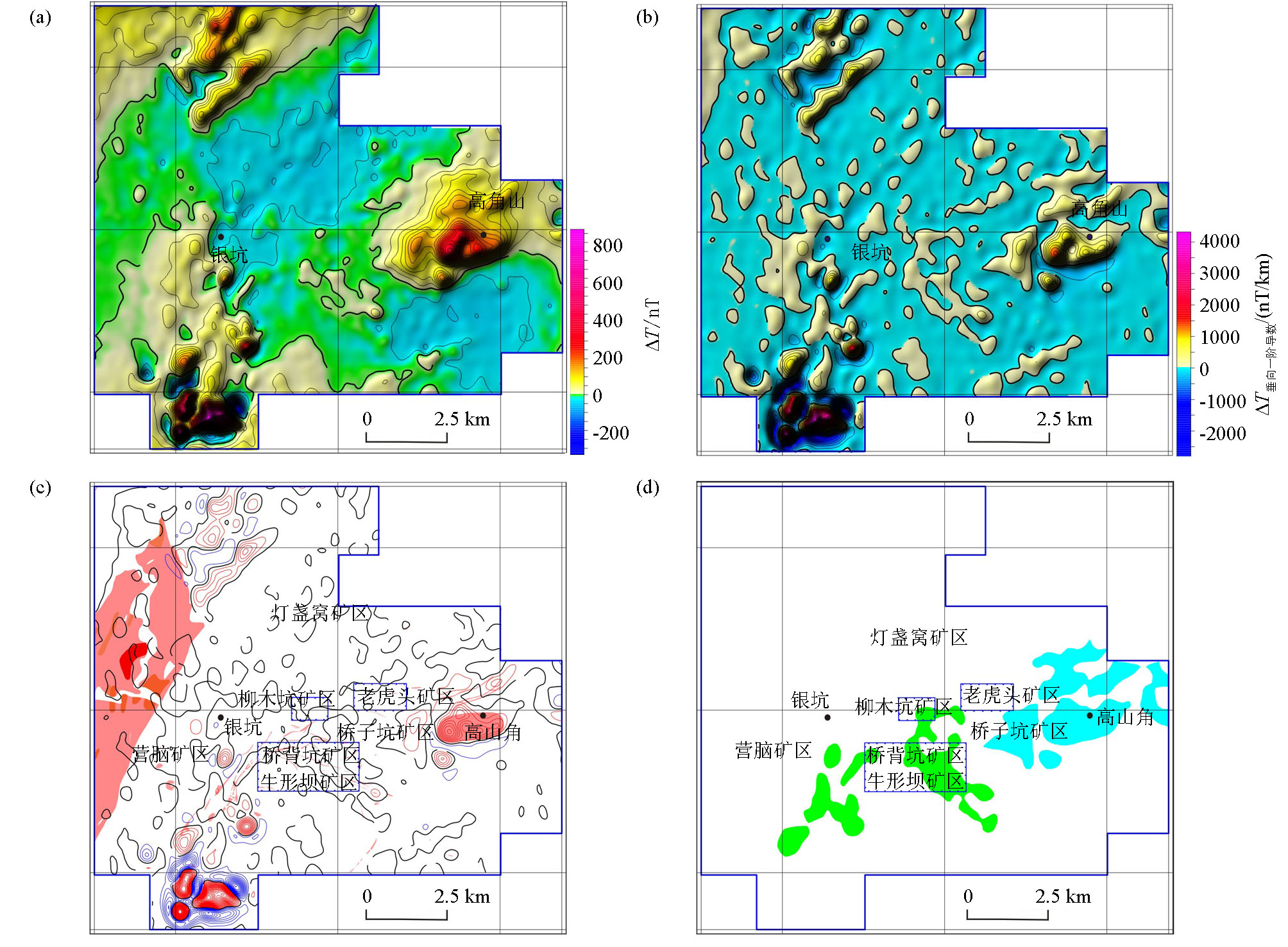
Fig.2); d—inferred planar distribution of the granite using high-precision ground magnetic survey data(blue indicates the inferred Gaoshanjiao granite; green indicates the inferred Liumukeng granite)
">

|
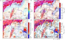
Characteristics of the high-precision magnetic anomaly reduction to the pole (RTP) and the deduction of granite distribution in the Yinkeng ore field
a—RTP magnetic anomaly map of the high-precision; b—vertical first-order derivative diagram of the magnetic anomaly of the high-precision RTP magnetic anomaly (thick black line: zero-value line of the vertical first-order derivative, same as below); c—vertical first-order derivative diagram of the magnetic anomaly of the high-precision RTP magnetic anomaly (distributions of the exposed magmatic rock attached; legend is the same as in Fig.2); d—inferred planar distribution of the granite using high-precision ground magnetic survey data(blue indicates the inferred Gaoshanjiao granite; green indicates the inferred Liumukeng granite)
|
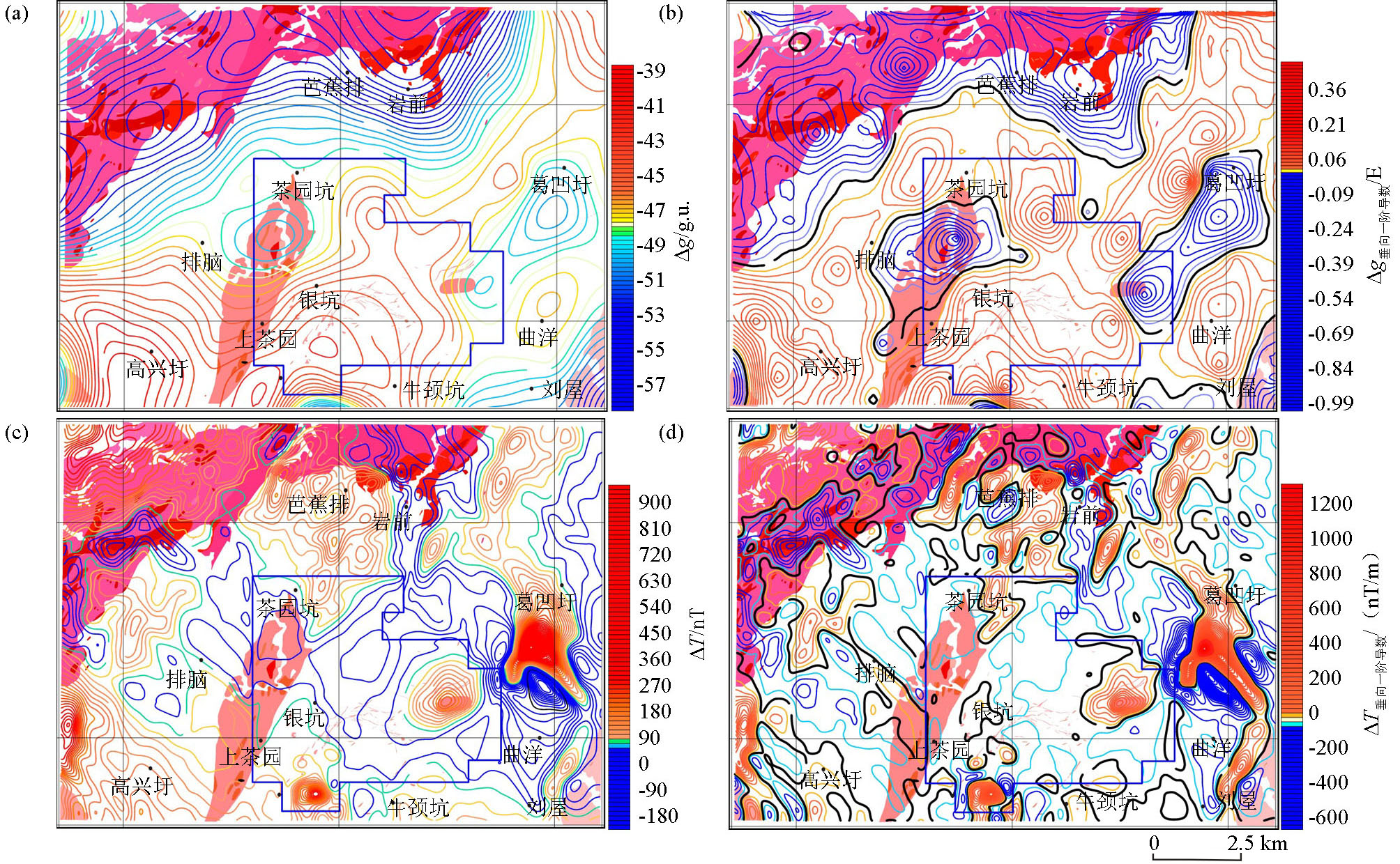
Fig. 2); b—vertical first-order derivative graph of the Bouguer gravity anomaly (thick black line is the zero-value line of the vertical first-order derivative, the same as below); c—aeromagnetic RTP magnetic anomaly chart; d—vertical first-order derivative chart of the aeromagnetic RTP magnetic anomaly
">
|
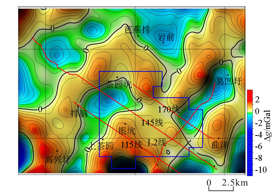
Relationship between the gravity and magnetic anomalies and the granite distributions in the Yinkeng Demonstration Area
a—bouguer gravity anomaly map (distribution of the exposed granite is attached, and the legend is the same as in Fig. 2); b—vertical first-order derivative graph of the Bouguer gravity anomaly (thick black line is the zero-value line of the vertical first-order derivative, the same as below); c—aeromagnetic RTP magnetic anomaly chart; d—vertical first-order derivative chart of the aeromagnetic RTP magnetic anomaly
|
|
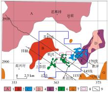
Comprehensively inferred planar position distributions of the granite using the gravity and magnetic data of the Yinkeng Demonstration Area
1—Jiangbei rock mass; 2—Changtan rock mass; 3—Gaoshanjiao rock mass; 4—Ge'aowei shallow rock mass; 5—Ge'aowei deep rock mass; 6—Liumukeng rock mass; 7—other rock masses; 8—ore field; 9—profile position
|
|
Residual Bouguer gravity anomaly map of the Yinkeng Demonstration Area
(red line denotes the profile positions; blue line is the Yinkeng ore field)
|
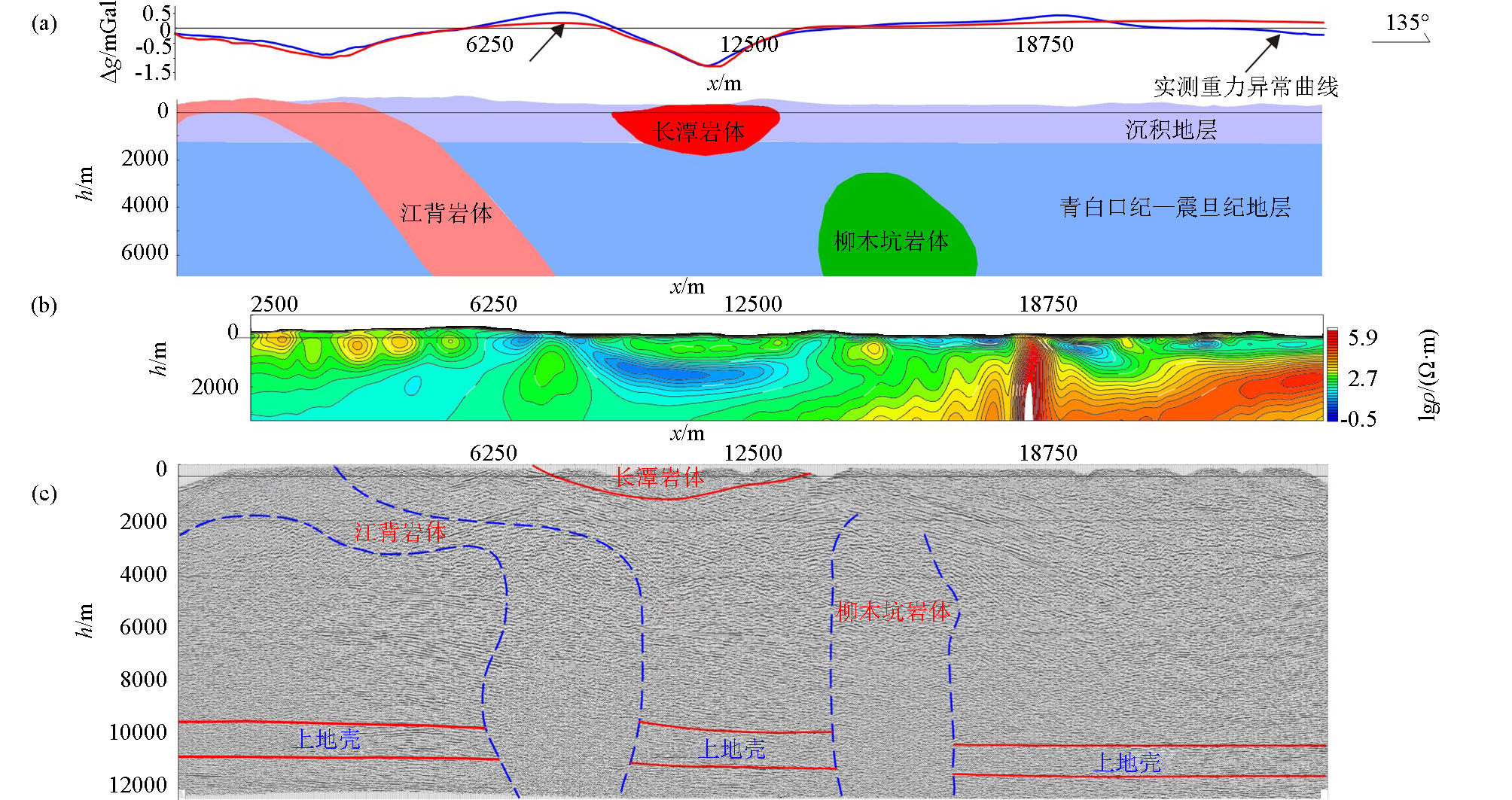
14]; c—2D reflection seismic stack profile results[25]
">
|
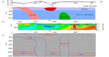
Granite distribution results obtained by the gravity, electrical and seismic inversion methods applied to Line 145 of the Yinkeng Demonstration Area
a—residual Bouguer anomaly inversion results; b—AMT resistivity profile[14]; c—2D reflection seismic stack profile results[25]
|

|
Three-dimensional layout of the granite profile locations of the four profiles in the Yinkeng Demonstration Area obtained by gravity (magnetic) inversion
1—Jiangbei rock mass; 2—Changtan rock mass; 3—Liumukeng rock mass; 4—Gaoshanjiao rock mass; 5—Ge'aowei rock mass;6—Sedimentary strata; 7—Qingbaikou-Sinian strata
|

| 岩体标号 | 岩体
名称 | 反演利用
的重(磁)
剖面资料 | 反演
剖面
线号 | 重磁场
特征 | 隐伏或
出露情
况 | 岩体断面空间分布特征 | | A | 江背花
岗岩体 | 1∶20万剩余布格重力异常 | 145线 | 低重,
高—弱
磁性 | 少部分出露,绝大部分隐伏 | 地表出露部分岩体薄,厚度不超过0.4 km,隐伏部分位于出露岩体的东南边,自西北向东南方向向下延伸,下底埋深达16.59 km,水平宽度为2.2~2.81 km | | B | 长潭花
岗岩体 | 1∶20万剩余布格重力异常 | 145线
115线 | 低重
弱磁 | 少部分出露,大部分隐伏 | 整体形状为椭圆形,向西南方向岩体厚度渐薄;
145线:下底面埋深约1.89 km,水平宽度约3.51 km;
115线:下底面埋深为0.25~0.43 km,水平宽度约3.5 km | | C | 高山角
花岗岩
体 | 1∶1万地面磁测,剩余布格重力异常 | L2线
170线 | 低重
高磁 | 出露面积小,绝大部分隐伏 | 呈柱状向地层深部延伸;
L2线:隐伏岩体上顶面埋深约0.33 km,下底面埋深约3.84 km,水平宽度0.578~1.92 km;
170线:隐伏岩体上顶面埋深为0.15~1.23 km,下底面埋深4.39 km,水平宽度为1.78~2.87 km | | D | 葛凹圩
浅部花
岗岩体 | 1∶20万剩余布格重力异常 | L2线 | 低重
高磁 | 完全隐伏 | 形状如椭圆形,上顶面埋深约0.52 km,下底面埋深达1.7 km,水平宽度约3.1 km | | E | 葛凹圩
深部花
岗岩体 | 1∶20万剩余布格重力异常 | L2线
170线 | 低重
弱磁 | 完全隐伏 | 形状如长条水平板状;
L2线:埋深和规模皆大,上顶面埋深为1.99~2.37 km,下底面约3.76 km,水平宽度达10.37 km;
170线:上顶面埋深约为2.35 km,下底面约4.38 km,水平宽度达2.83 km | | F | 柳木坑
花岗岩
体 | 1∶1万地面磁测,1∶20万剩余布格重力异常 | 145线
115线 | 相对低
重,中—
弱磁性 | 完全隐伏 | 岩体浅部为起伏岩体,故高精度地磁资料识别的是浅部岩凸位置;
岩体深部呈柱状向地层内部延伸;
上顶面埋深2.63~5.34 km,下底面埋深约17.18 km,水平宽度为2.2~3.8 km,整体规模较大。 |
|
Spatial distribution characteristics of the granite in the Yinkeng Demonstration Area inverted by the gravity (magnetic) anomaly profiles
|
| [1] |
陈毓川, 裴荣富, 张宏良 . 南岭地区与中生代花岗岩类有关的有色、稀有金属矿床地质[J].中国地质科学院院报, 1990(1):79-85.

|
| [1] |
Chen Y C, Pei R F, Zhang H L , et al. Geology of nonferrous and rare metal deposits related to mesozoic granitoids in the Nanling regions,China[J].Bulletin of the Chinese Academy of Geological Sciences, 1990(1):79-85.
|
| [2] |
王登红, 陈振宇, 黄凡 , 等. 南岭岩浆岩成矿专属性及相关问题探讨[J]. 大地构造与成矿学, 2014,38(2):230-238.
|
| [2] |
Wang D H, Chen Z Y, Huang F , et al. Discussion on metallogenic specialization of the magmatic rocks and related issues in the nanling region[J]. Geotectonica et Metallogenia, 2014,38(2):230-238.
|
| [3] |
孙涛 .新编华南花岗岩分布图及其说明[J].地质通报, 2006(3):332-335, 426-427.
|
| [3] |
Sun T . A new map showing the distribution of granites in South China and its explanatory notes[J].Geological Bulletin of China, 2006(3):332-335, 426-427.
|
| [4] |
舒良树, 周新民, 邓平 , 等. 南岭构造带的基本地质特征[J].地质论评, 2006(2):251-265.
|
| [4] |
Shu L S, Zhou X M, Deng P , et al. Principal geological features of Nanling tectonic belt, South China[J].Geological Review, 2006(2):251-265.
|
| [5] |
秦葆瑚 . 南岭区域重磁异常的地质解释[J].湖南地质, 1987(1):1-15.
|
| [5] |
Qin B H . A geological interpretation on the regional gravity and magnetic anomalies in Nanling area[J].Hunan Geology, 1987(1):1-15.
|
| [6] |
孙德梅, 曾青石 . 华南花岗岩深部构造的地球物理场特征及其找矿意义[J].中国地质科学院矿床地质研究所所刊, 1987(2):129-134.
|
| [6] |
Sun D M, Zeng Q S . Deep structures of the granites and characteristics of the geophysical fields in south China and their significance in ore prospecting[J].Bulletin of the Institite of Mineral Deposits Chinese Academy of Geological Sciences, 1987(2):129-134.
|
| [7] |
饶家荣, 金小燕, 曾春芳 . 南岭中段北缘深部构造—岩浆(岩)控矿规律及找矿方向[J].国土资源导刊, 2006(3):31-36.
|
| [7] |
Rao J R, Jin X Y, Zeng C F . Ore-controlling regularity and prospecting direction of deep structure-magma (rock) in the northern margin of the middle Nanling Mountains[J].Land & Resources Herald, 2006(3):31-36.
|
| [8] |
黄金明 . 重磁数据处理解释技术在华南地区岩体圈定与形态反演中的应用研究[D].北京:中国地质大学(北京), 2013.
|
| [8] |
Huang J M . The study of gravity and magnetic data processing and interpretation method on boundary delineation and shape inversion of rock body in South China[D].Beijing:China University of Geosciences( Beijing) , 2013.
|
| [9] |
刘鹏飞, 刘天佑, 陈国雄 . 南岭花岗岩重力场特征与找矿意义[J]. 工程地球物理学报, 2013,10(1):1-6.
|
| [9] |
Liu P F, Liu T Y, Chen G X . Characteristics of Nanling granite gravity field and significance of prospecting[J]. Chinese Journal of Engineering Geophysics, 2013,10(1):1-6.
|
| [10] |
孙劲松 . 南岭成矿带重磁场特征研究[D].武汉:中国地质大学(武汉), 2013.
|
| [10] |
Sun J S . Study on the characteristics of gravity and magnetic field in Nanling Metallogenic Belt[D].Wuhan:China University of Geosciences(Wuhan), 2013.
|
| [11] |
陈国雄, 刘天佑, 孙劲松 , 等. 南岭成矿带多尺度重力场及深部构造特征[J]. 地球科学:中国地质大学学报, 2014,39(2):240-250.
|
| [11] |
Chen G X, Liu T Y, Sun J S , et al. Characteristics of multi-scale gravity field and deep structure in Nanling Metallogenic Belt[J]. Earth Science:Journal of China University of Geosciences, 2014,39(2):240-250.
|
| [12] |
王万银, 王云鹏, 李建国 , 等. 利用重、磁资料研究于都—赣县矿集区盘古山地区断裂构造及花岗岩体分布[J]. 物探与化探, 2014,38(4):825-834.
|
| [12] |
Wang W Y, Wang Y P, Li J G , et al. Study on the faults structure and granite body distribution in Pangushan area of Yudu-Ganxian ore district using gravity and magnetic data[J]. Geophysical and Geochemical Exploration, 2014,38(4):825-834.
|
| [13] |
刘金兰, 赵斌, 王万银 , 等. 利用重磁资料研究南岭于都—赣县矿集区花岗岩与断裂分布特征[J]. 地质学报, 2014,88(4):658-668.
|
| [13] |
Liu J L, Zhao B, Wang W Y , et al. A study of the granite and faults distribution based on gravity and magnetic data obtained in Yudu-Ganxian Ore Concentration Area of Nanling[J]. Acta Geologica Sinica, 2014,88(4):658-668.
|
| [14] |
冯兵, 李建国, 赵斌 , 等. 音频大地电磁法在南岭于都—赣县矿集区银坑示范区深部矿产资源探测中的应用[J]. 地质学报, 2014,88(4):669-675.
|
| [14] |
Feng B, Li J G, Zhao B , et al. The application of audio magnetotelluric method(AMT) in Nanling Yudu-Gan County Ore-Concentrated Area Yinkeng Demonstration Plot to survey deep mineral resources[J]. Acta Geologica Sinica, 2014,88(4):669-675.
|
| [15] |
魏祥荣 . 遥感在南岭带赣南段构造研究中的应用[J]. 华东铀矿地质, 2001 ( 1):21-30.
|
| [15] |
Wei X R . Application of remote sensing in structural study of Southern Jiangxi Section of Nanling Zone[J]. East China Uranium Geology, 2001 ( 1):21-30.
|
| [16] |
姜枚, 贾秀敏 . 南岭花岗岩岩石物理性质的研究[J].中国地质科学院矿床地质研究所所刊, 1989(1):145-155.
|
| [16] |
Jiang M, Jia X M . Physical properties of granite rocks in Nanling region[J].Bulletin of the Institite of Mineral Deposits Chinese Academy of Geological Sciences, 1989(1):145-155.
|
| [17] |
李建国, 赵斌, 孙少伟 , 等. 南岭于都—赣县矿集区的综合物性特征[J]. 工程地球物理学报, 2013,10(3):313-319.
|
| [17] |
Li J G, Zhao B, Sun S W , et al. On comprehensive physical property of mineralization concentrated region in Yudu-Ganxian[J]. Chinese Journal of Engineering Geophysics, 2013,10(3):313-319.
|
| [18] |
Hood P, McClure D J . Gradient measurements in ground magnetic prospecting[J]. Geophysics, 1965,30(3):403-410.
|
| [19] |
Bhattacharyya B K . Two-dimensional harmonic analysis as a tool for magnetic interpretation[J]. Geophysics, 1965,30(5):829-857.
|
| [20] |
钟清, 孟小红, 刘士毅 . 重力资料定位地质体边界问题的探讨[J]. 物探化探计算技术, 2007,29(s):35-38.
|
| [20] |
Zhong Q, Meng X H, Liu S Y . Discussion on the boundary problem of geological body location with gravity data[J]. Computing Techniques for Geophysical and Geochemical Exploration, 2007,29(s) : 35-38.
|
| [21] |
Cordell L. Gravimetric expression of graben faulting in SantaFe Country and the Espanola Basin [C]//Guidebook,30th Field Conf.,New Mexico:New Mexico Geol. Soc., 1979: 59-64.
|
| [22] |
余钦范, 楼海 . 水平梯度法提取重磁源边界位置[J]. 物探化探计算技术, 1994,16(4):363-367.
|
| [22] |
Yu Q F, Lou H . Locating the boundaries of magnetic or gravity sources using horizontal gradient anomalies[J]. Computing Techniques for Geophysical and Geochemical Exploration, 1994,16(4):363-367.
|
| [23] |
周蒂, 王万银, 庞雄 , 等. 地球物理资料所揭示的南海东北部中生代俯冲增生带[J]. 中国科学D辑:地球科学, 2006,36(3):209-218.
|
| [23] |
Zhou D, Wang W Y, Pang X , et al. Mesozoic subduction accretion zone in northeastern South China Sea revealed by geophysical data[J]. Science in China Ser.D :Earth Sciences, 2006,36(3):209-218.
|
| [24] |
Wang W Y, Pan Y, Qiu Z Y . A new edge recognition technology based on the normalized vertical derivative of the total horizontal derivative for potential field data[J]. Applied Geophysics, 2009,6(3):226-233.
|
| [25] |
陈毓川, 陈郑辉, 曾载淋 , 等. 南岭科学钻探第一孔选址研究[J]. 中国地质, 2013,40(3):659-670.
|
| [25] |
Chen Y C, Chen Z H, Zeng Z L , et al. Research on the site selection of Nanling Scientific Drilling-1[J]. Geology in China, 2013,40(3):659-670.
|
| [26] |
刘申叔, 李上卿 . 东海油气地球物理勘探[M]. 北京: 地质出版社, 2001.
|
| [26] |
Liu S S, Li S Q. Geophysical exploration of oil and gas in the East China Sea[M]. Beijing: Geological Publishing House, 2001.
|
| [27] |
陈毓川 . 中国成矿体系与区域成矿评价[M]. 北京: 地质出版社, 2007.
|
| [27] |
Chen Y C. Chinese mineralization system and assessment of regional mineralization[M]. Beijing: Geological Publishing Press, 2007.
|
| [28] |
邓晋福, 赵国春, 赵海玲 , 等. 中国东部燕山期火山岩构造组合与造山—深部过程[J]. 地质评论, 2000,46(1):41-48.
|
| [28] |
Deng J F, Zhao G C, Zhao H L , et al. Yanshanian igneous petrotectonic assemblsge and orogenic-deep pressess in east China[J]. Geological Review, 46(1):41-48.
|
| [1] |
LI Jian-Ting, LIU Xue-Min, WANG Xue-Qiu, HAN Zhi-Xuan, JANG Yao. Tracing and identification of concealed Luoboling copper-molybdenum deposit in Fujian Province using trace elements and isotopes in fine-grained surface soils[J]. Geophysical and Geochemical Exploration, 2022, 46(1): 32-45. |
| [2] |
ZHAO Ze-Lin, LI Jun-Jian, ZHANG Tong, NI Zhen-Ping, PENG Yi, SONG Li-Jun. Geological characteristics and prospecting direction of rare earth element deposits in North China[J]. Geophysical and Geochemical Exploration, 2022, 46(1): 46-57. |
|
|
|
|