|
|
|
| Research on technology of batch customizing aero geophysical survey regions maps |
| Lei FENG, Wei ZHOU, Yao CHEN, Wen-Ji LI |
| China Aerospace Geophysical and Remote Sensing Center for Natural Resources, Beijing 100083,China |
|
|
|
|
Abstract Aero geophysical survey regions maps reflect the information of aero geophysical survey work in the past, and also provide references for survey data collection and survey work planning. In order to fulfill the large demand of industrial and social users for multi-scale and cross-regional aero geophysical survey regions maps, the authors employed National Aero Geophysical Metadata Database established by AGRS to carry out studies of batch creating maps. According to the technical route of “graphic standards stored in data dictionary, drawing style managed by template files, dynamic drawing elements by user parameters”, the technique of batch customizing aero geophysical survey regions maps is realized. The technology achieved good application results in the socialized service of aero geophysical survey data and the project deployment and implementation of “Aero geophysical surveys in key ore-forming areas such as Qinling and Tianshan”.
|
|
Received: 06 September 2018
Published: 20 February 2019
|
|
|
|
|
|

|
Current drawing map workflow
|
|
Example of aero geophysical survey regions map
|
|
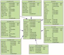
Metadata tables of aero geophysical survey regions
|

| 序号 | 比例尺 | COLOR | RGB | 颜色样例 | | 1 | 1∶10000 | #FF7F00 | 255,125,0 | ![]() | | 2 | 1∶50000 | #FFFF00 | 255,255,0 | ![]() | | 3 | 1∶100000 | #0070FF | 0,110,255 | ![]() | | 4 | 1∶250000 | #6EB446 | 110,180,70 | ![]() | | 5 | 1∶500000 | #96DCF0 | 150,220,240 | ![]() | | 6 | 1∶1000000 | #D2D2D2 | 210,210,210 | ![]() | | 7 | …… | …… | …… | …… |
|
|
|
| 序号 | 测量方法 | 线型 | 线颜色 | 线型样例 | | 1 | 航磁 | DASHED | 255,0,0 | ![]() | | 2 | 航重 | DOTTED | 0,255,0 | ![]() | | 3 | 航放 | DASHDOT | 0,0,255 | ![]() | | 4 | 航电 | DASHDOTDOT | 100,100,100 | ![]() | | 5 | 航空遥感 | SOLID | 0,0,0 | ![]() | | 6 | …… | …… | …… | …… |
|
|
|
| 序号 | 测量精度 | 填充 | 填充样例 | | 1 | 中低精度 | DOTTED | ![]() | | 2 | 高精度 | SOLID | ![]() | | 3 | …… | …… | …… |
|
|
|
| 序号 | 字段名 | 字段描述 | 字段类型 | 备注 | | 1 | ID | 序号 | INT | 主键ID | | 2 | MB_NAME | 模板名称 | VARCHAR(100) | 一套模板对应一系列参数 | | 3 | TITLE_VISIBLE | 图名是否可见 | BOOL | 1—可见,0—不可见 | | 4 | COMPASS_VISIBLE | 指北针是否可见 | BOOL | 1—可见,0—不可见 | | 5 | LEGEND_VISIBLE | 图例是否可见 | BOOL | 1—可见,0—不可见 | | 6 | SCALE_VISIBLE | 比例尺是否可见 | BOOL | 1—可见,0—不可见 | | 7 | GRID_VISIBLE | 图框网格是否可见 | BOOL | 1—可见,0—不可见 | | 8 | TITLE_SIZE | 图名字号大小 | INT | 字号 | | 9 | TITLE_VERTICAL | 图名水平位置 | INT | 1—居左,2—居中,3—居右 | | 10 | TITLE_HORIZON | 图名垂直位置 | INT | 1—居上,2—居中,3—居下 | | 11 | TITLE_TOP | 图名向上偏移量 | FLOAT | 中心点离原位置的偏移量 | | 12 | TITLE_LEFT | 图名向左偏移量 | FLOAT | 中心点离原位置的偏移量 | | 13 | COMPASS_SIZE | 指北针大小 | FLOAT | 指北针默认大小,百分比 | | 14 | COMPASS_VERTICAL | 指北针水平位置 | INT | 1—居左,2—居中,3—居右 | | 15 | COMPASS_HORIZON | 指北针垂直位置 | INT | 1—居上,2—居中,3—居下 | | 16 | COMPASS_TOP | 指北针向上偏移量 | FLOAT | 中心点离原位置的偏移量 | | 17 | COMPASS_LEFT | 指北针向左偏移量 | FLOAT | 中心点离原位置的偏移量 | | 18 | LEGEND_SIZE | 图例大小 | FLOAT | 图例默认大小,百分比 | | 19 | LEGEND_VERTICAL | 图例水平位置 | INT | 1—居左,2—居中,3—居右 | | 20 | LEGEND_HORIZON | 图例垂直位置 | INT | 1—居上,2—居中,3—居下 | | 21 | LEGEND_TOP | 图例向上偏移量 | FLOAT | 中心点离原位置的偏移量 | | 22 | LEGEND_LEFT | 图例向左偏移量 | FLOAT | 中心点离原位置的偏移量 | | 23 | SCALE_SIZE | 比例尺大小 | FLOAT | 比例尺默认大小,百分比 | | 24 | SCALE_VERTICAL | 比例尺水平位置 | INT | 1—居左,2—居中,3—居右 | | 25 | SCALE_HORIZON | 比例尺垂直位置 | INT | 1—居上,2—居中,3—居下 | | 26 | SCALE_TOP | 比例尺向上偏移量 | FLOAT | 中心点离原位置的偏移量 | | 27 | SCALE_LEFT | 比例尺向左偏移量 | FLOAT | 中心点离原位置的偏移量 | | 28 | …… | …… | …… | …… |
|
Data dictionary of basic infomation in maps
|
|
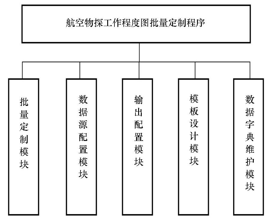
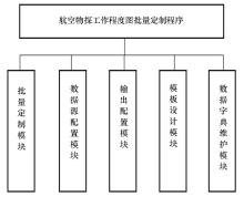
Main function modules of the program
|

|
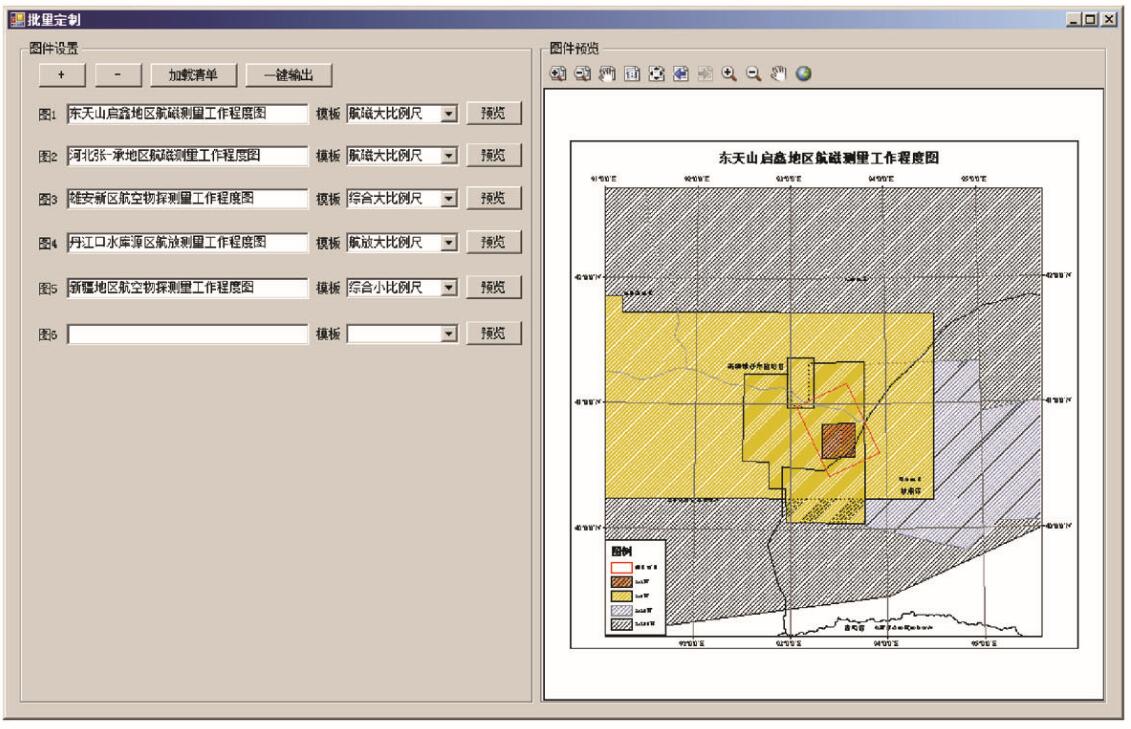
Interface of batch drawing maps
|

|
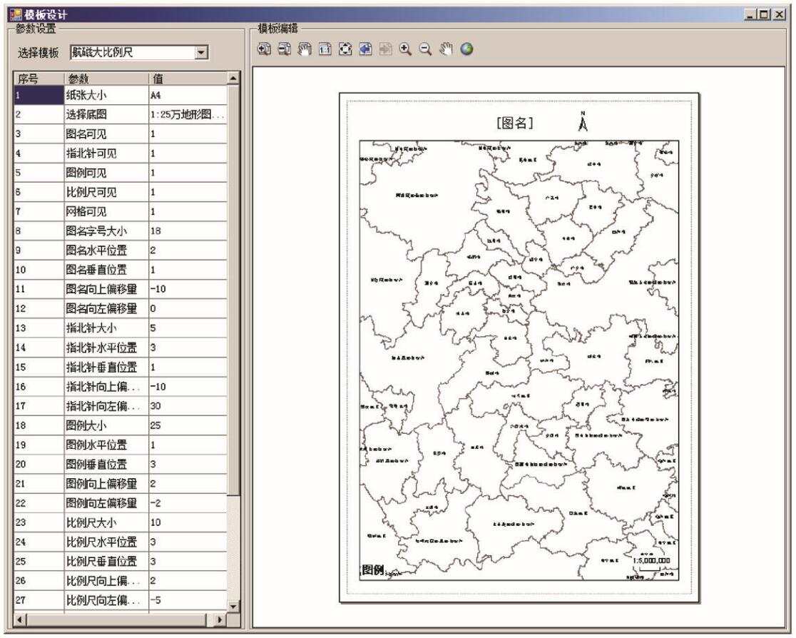
Interface of templates design
|
|
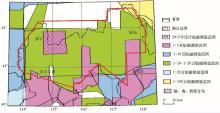
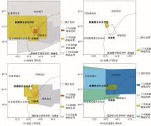
Aero magnetic, electrical, radioactive survey regions maps
a—aero magnetic survey regions map;b—aero electrical survey regions map; c—aero radioactive survey regions map;d—aero remote sensing survey regions map
|
| [1] |
张翠光, 杨建峰, 任收麦 , 等. 全国地质调查工作程度图集[R]. 中国地质调查局发展研究中心, 2016.
|
| [1] |
Zhang C G, Yang J F, Ren S M , et al. National atlas of geological survey work degree [R]. Development and Research Center of China Geological Survey, 2016.
|
| [2] |
聂凤军 . 航空物探在水工环勘查中的应用[J]. 科技论坛, 2013: 27-30.
|
| [2] |
Nie F J . Application of aerial geophysical exploration in hydro-environmental exploration[J]. Technology Forum, 2013: 27-30.
|
| [3] |
李怀渊, 江民忠, 陈国胜 , 等. 我国航空放射性测量进展及发展方向[J]. 物探与化探, 2018,42(4):645-652.

|
| [3] |
Li H Y, Jiang M Z, Chen G S , et al. The brilliant achievements and technological Innovation of airborne radioactivity survey in China[J]. Geophysical and Geochemical Exploration, 2018,42(4) : 645-652.
|
| [4] |
陈志军, 陈建国 . 系列地图批处理自动成图解决方案——以勘查地球化学系列图为例[J]. 地质学刊, 2013,37(3):456-464.
|
| [4] |
Chen Z J, Chen J G . Automated batch mapping solution for serial maps: A case study of exploration geochemistry maps[J]. Journal of Geology, 2013,37(3):456-464.
|
| [5] |
闫红雨, 杨玲羽, 付敖云 . 航空物探数字制图与印刷技术规定[R]. 中国国土资源航空物探遥感中心, 2015.
|
| [5] |
Yan H Y, Yang L Y, Fu A Y . Technical regulations for digital mapping and printing of aero geophysical survey[R]. China Aero Geophysical Survey and Remote Sensing Center for Land Resources, 2015.
|
| [6] |
贾桂芬 . 专题地图的地理底图编制及编辑加工——以《中华人民共和国1∶25万航磁系列图》为例[J]. 传播与版权, 2018(3):62-64.
|
| [6] |
Jia G F . The compilation and editing of the geographical base map of the thematic maps——taking the "1∶250,000 aeromagnetic series of The People's Republic of China" as an example[J]. Communication and Copyright, 2018(3):62-64.
|
| [7] |
吴高微, 闫红雨 . 基于MapGIS K9的航空物探图框绘制软件开发[J]. 物探与化探, 2014,38(3):607-609.
|
| [7] |
Wu G W, Yan H Y . The development of airborne geophysical map frame drawing software based on MapGIS K9[J]. Geophysical and Geochemical Exploration, 2014,38(3):607-609.]
|
| [8] |
李敬敏, 闫红雨, 李诗珺 , 等. 航空地球物理调查全矢量插图编图方法[J]. 工程地球物理学报, 2017,14(1):37-44.
|
| [8] |
Li J M, Yan H Y, Li S J , et al. Vector illustration map compilation method for airborne geophysical survey[J]. Chinese Journal of Engineering Geophysics, 2017,14(1):37-44.
|
| [9] |
王卫平, 吴成平, 马勋表 . 黔东地区航磁特征与岩性构造填图[J]. 中国地质调查, 2018,5(01):37-43.
|
| [9] |
Wang W P, Wu C P, Ma X B . Aeromagnetic field feature and lithologic mapping in eastern Guizhou[J]. Geological Survey of China, 2018,5(1):37-43.
|
| [10] |
眭素文, 于长春, 熊盛青 . 中高山区高精度航磁视磁化强度填图方法[J]. 地球物理学进展, 2004,19(2):357-362.
|
| [10] |
Sui S W, Yu C C, Xiong S Q . Apparent magnetization mapping from high resolution aeromagnetic data in the region of high topographic relief[J]. Progress in Geophysics, 2004,19(2):357-362.
|
| [11] |
李文勇, 周德文 . 河北张家口—承德地区航磁调查成果报告[R]. 中国国土资源航空物探遥感中心, 2015.
|
| [11] |
Li W Y, Zhou D W . Report on aeromagnetic survey results in Zhangjiakou-Chengde Area, Hebei Province [R]. China Aero Geophysical Survey and Remote Sensing Center for Land Resources, 2015.
|
| [12] |
宋杨, 万幼川 . 一种新型空间数据模型Geodatabase[J]. 测绘通报, 2014,11:31-33.
|
| [12] |
Song Y, Wan Y C . The new spatial data model of Arc/Info 8 —Geodatabase[J]. Bulletin of Surveying and Mapping, 2014,11:31-33.
|
| [13] |
郝纪杰, 康光清, 马瞳宇 , 等. 基于ArcEngine地理信息数据库管理系统的研究与实现[J]. 测绘与空间地理信息, 2018,41(1):113-115,118.
|
| [13] |
Hao J J, Kang G Q, Ma T Y , et al. Research and implementation of geographic information database management system based on arcengine[J]. Geomatics & Spatial Information Technology, 2018,41(1):113-115,118.
|
| [14] |
汪敏, 余晨曦 . ArcGIS地理数据库驱动的快速出图技术[J].测绘通报, 2017(5):129-131.
|
| [14] |
Wang M, Yu C X . Research of rapid cartographical technology based on geodatabase in ArcGIS[J]. Bulletin Of Surveying and Mapping, 2017(5):129-131.
|
| [15] |
张龙, 汪新庆, 康承旭 . 基于符号提取的地质要素子类动态划分技术[J]. 科学技术与工程, 2013,13(30):8986-8990.
|
| [15] |
Zhang L, Wang X Q, Kang C X . The subclass dynamic classification of geological features based on symbols extraction[J]. Science Technology and Engineering, 2013,13(30):8986-8990.
|
| [16] |
汪新庆, 康承旭 . 数据字典在地质矿产术语分类代码修编平台中的应用[J]. 地质学刊, 2014,38(3):408-411.
|
| [16] |
Wang X Q, Kang C X . Application of data dictionary in revision platform of geology and minerals terminology classification codes[J]. Journal of Geology, 2014,38(3):408-411.
|
| [17] |
王林飞, 薛典军, 李芳 , 等. 海洋航空物探数据库建设进展[J]. 海洋地质前沿, 2017,34(3):8-14.
|
| [17] |
Wang L F, Xue D J . A Marine aeromagnetic database for efficient data management[J]. Marine Geology Frontiers, 2017,34(3):8-14.
|
| [18] |
刘浩军 . 航空物探平剖图自动绘制的可视化处理[J]. 物探与化探, 2004,28(2):147-149.
|
| [18] |
Liu H J . Visualization proccesion of aero geophysical profile map in automatic plotting[J]. Geophysical and Geochemical Exploration, 2004,28(2):147-149.
|
| [19] |
王海涛, 苏志军, 秦进春 . 基于ArcEngine的带状图批量制图方法研究[J]. 测绘与空间地理信息, 2017,40(8):54-67.
|
| [19] |
Wang H T, Su Z J, Qin J C . Study on batch mapping method of strip chart based on ArcEngine[J]. Geomatics and Spatial Information Technology, 2017,40(8):54-67.
|
| [20] |
张龙, 汪新庆 . 基于数据字典的空间数据库通用建库技术[J]. 国土资源遥感, 2014,26(1):173-178.
|
| [20] |
Zhang L, Wang X Q . General Geo-spatial database construction method based on data dictionary[J]. Remote Sensing for Land & Resources, 2014,26(1):173-178.
|
| [21] |
汪新庆, 刘刚, 韩志军 , 等. 地质矿产点源数据库系统的模型库及其分类体系[J]. 地球科学, 1998,23(2):199-203.
|
| [21] |
Wang X Q, Liu G, Han Z J . The case model base and its classification system of geological and mineral point -source database system[J]. Earth Science, 1998,23(2):199-203.
|
| [22] |
康承旭, 汪新庆, 缪谨励 , 等. 云平台下mapgis图件在arcgis中还原显示技术研究[J]. 测绘科学技术学报, 2015,32(5):539-544.
|
| [22] |
Kang C X, Wang X Q, Miao J L , et al. Study of restoration display of mapgis maps in arcgic based on cloud platform[J]. Journal of Geomatics Science and Technology, 2015,32(5):539-544.
|
| [23] |
张龙 . 地质矿产图例符号数据模型及应用——以全国矿产资源潜力评价数据为例[D].武汉:中国地质大学( 武汉),2014.
|
| [23] |
Zhang L . Geological minerals legend symbol data model and its application——take the national mineral resources potential evaluation data as an example[D]. Wuhan: China University Of Geosciences( Wuhan), 2014.
|
| [24] |
汪新庆, 方勇军 . 矿产地质志数据模型应用技术研究[J]. 地质学刊, 2017,41(3):379-383.
|
| [24] |
Wang X Q, Fang Y J . Research on application technology of mineral geology data model[J]. Journal of Geology, 2017,41(3):379-383.
|
| [25] |
万建华, 熊盛青, 范正国 , 等. 全国航空物探工作现状及未来工作重点浅析[J]. 中国矿业, 2011,S1:151-154.
|
| [25] |
Wan J H, Xiong S Q, Fan Z G . The current situation and the future focus of aero geophysical survey in China[J]. China Mining Magazine, 2011,S1:151-154.
|
| [26] |
夏玲燕, 杨雪, 丁燕云 . 中国陆域航磁系列图编制与研究进展[J]. 物探与化探, 2017,41(5):958-962.
|
| [26] |
Xia L Y, Yang X, Ding Y Y . The progress in the compilation and study of aeromagnetic map series for China’s land field[J]. Geophysical and Geochemical Exploration, 2017,41(5):958-962.
|
|
|
|