|
|
|
| The application effect of EH-4 under different geological backgrounds |
| Ying-Bin LI1,2, Yi LI1,2, Zhan-Bin ZHANG1,2, Wei ZHANG1,2 |
1. Airborne Survey and Remote Sensing Center of Nuclear Industry, Shijiazhuang 050002, China
2. Key Laboratory of Uranium Resources Geophysical Exploration Technology, China Nuclear Industry Group Company, Shijiazhuang 050002, China |
|
|
|
|
Abstract EH-4 has been applied to many fields, such as mineral exploration and engineering exploration. Nevertheless, because of the limitation of the acquisition frequency as well as geological and geophysical conditions, the application effects of EH-4 in different geological backgrounds are different. In order to prove the argument that the geological geophysical work in EH-4 is reasonable, the authors analyzed the EH-4 effects in exploration of Lianshangguan hard rock type uranium, sandstone type uranium deposit in Erlian Basin and mined out region of Yili basin in Xinjiang. The results show that, in the hard rock area, the depth of EH-4 exploration generally can reach 1000 m or so, and the detection of faults, the contact zone of rock bodies and its strike and spatial distribution can yield fairly good application effect; in sedimentary basins, the exploration effect of EH-4 is affected by the overall depth of resistivity and surface resistivity, the exploration depth may sometimes only reach two hundred or three hundred meters, but can sometimes reach five hundred or six hundred meters. Although the depth of exploration is not big, but the shallow geoelectric properties reflect good effect.
|
|
Received: 13 July 2018
Published: 31 May 2019
|
|
|
|
|
|

| 岩性 | ρ/(Ω· m) | | 最大值 | 最小值 | 平均值 | | 浪子山组二云片岩 | 933 | 98 | 267 | | 浪子山组石英岩 | 16500 | 7853 | 8598 | | 混合花岗岩 | 2568 | 1453 | 2145 | | 变粒岩 | 2598 | 1257 | 2087 | | 变辉长岩 | 3056 | 1025 | 1952 |
|
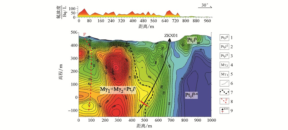
The statistical table of rock resistivity in Lianshanguan area[8,9]
|

|
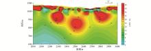
L14 line RaA method for radon and AMT inversion resistivity section interpretation interpretation map
1—group of three prodigal mountain marble; 2—group two prodigal mountain schist; 3—a prodigal mountain group quartzite; 4—Paleoproterozoic Neoarchaean mixed granite; 5—mixed granite; 6—inferred geological boundary; 7—inferred contact; 8—inferred fault; 9—drilling and ore position
|
| 地层代号 | 主要岩性 | ρ/(Ω·m) | | 第四系(Q) | 黄土、黏土、沙、砾石 | 5~150 | | 新近系(N)、古近系(E) | 泥岩、砂质泥岩、粗砂岩、砂砾岩、砾石 | 10~150 | | 白垩系上统(K2e) | 盐层、泥岩、细砂岩、含砾中粗砂岩 | 6.0~40 | | 白垩系下统 | 巴彦花群二段(K1bs2) | 红色泥岩、粉砂岩,其间夹中细砂岩 | 2.0~12 | | 含砾粗砂岩、粗砂岩、泥质砂岩 | 10.0~20 | | 巴彦花群一段(K1bs1) | 炭质泥岩、中细砂岩 | 5~10 | | 泥—砂—砾混杂堆积 | 5~40 | | 灰白色花岗质砾岩夹泥质中细砂岩 | 16~44 | | 侏罗系上统(J3) | 火山碎屑岩、火山熔岩 | 50~500 | | 侏罗系中下统(J1-2) | 砂岩、泥岩、碳质页岩 | 50~500 |
|
The statistical table of resistivity parameters of caprock and rock mass in Erlian Basin[11]
|

|
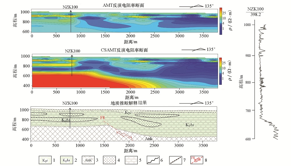
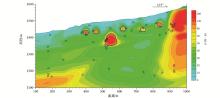
Inversion of resistivity profile and geological interpretation map of H15K01 line (2008 AMT surveying L02 line)
1—Erlian group of The upper Cretaceous; 2—the lower Cretaceous Saihan formation; 3—pre Cretaceous basement; 4—sandstone; 5—mudstone; 6—angle unconformity geological boundary; 7—facies boundary; fault 8—inference
|
|
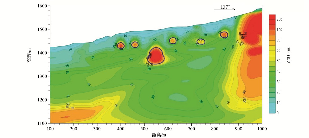
Inversion resistivity profile of 2006L02 line
|
|
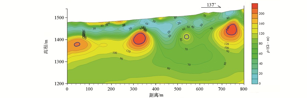
Inversion resistivity profile of L11 line
|

|
Interpretation section of L29 line interpretation
|
| [1] |
叶益信, 邓居智, 方根显 . 高频大地电磁测深(EH-4)在热储构造勘查中的试验研究——以抚州地热区为例[J]. 地质与勘探, 2011,47(4):649.
|
| [1] |
Ye Y X, Deng J Z, Fang G X . The test research of high frequency magnetotelluric sounding 12 to reservoir structure survey: taking the Fuzhou geothermal area in Jiangxi province as an example[J]. Geology and Exploration, 2011,47(4):649.
|
| [2] |
席振铢, 冯万杰, 李瑞雪 , 等. 低阻覆盖层对高频大地电磁测深的影响[J]. 地质与勘探, 2011,47(4):673.
|
| [2] |
Xi Z Z, Feng W J, Li R X , et al. Effect of a low-resistivity cover on high-frequency magnetotelluric sounding[J]. Geology and Exploration, 2011,47(4):673.
|
| [3] |
李彬, 孙莉芳, 郭甲一 , 等. EH-4技术在豫西菊竹沟金矿区的应用[J].物探与化探,2016, 40(1):51-54.

|
| [3] |
Li B, Sun L F, Guo J Y , et al. The application of EH-4 technology to the Juzhugou gold ore district in western Henan Province[J]. Geophysical and Geochemical Exploration, 2016, 40(1):51-54.
|
| [4] |
孔志召, 吴勇 . 南方硬岩地区EH-4资料处理的若干问题——以沙子江矿床为例[J]. 物探与化探, 2016,40(4):804-808.DOI: 10.11720/wtyht.2016.4.26
|
| [4] |
Kong Z Z, Wu Y . A discussion on some EH-4 measurement problems in hard-rock areas in southern China:A case study of the Shazijiang deposit[J]. Geology and Exploration, 2016,40(4):804-808.DOI: 10.11720/wtyht.2016.4.26
|
| [5] |
柳建新, 童孝忠, 程云涛 , 等. 有效视电阻率在音频大地测量数据二维反演中的应用[J]. 地质与勘探, 2008,44(3):56.
|
| [5] |
Liu J X, Tong X Z, Cheng Y T , et al. Application of effective appar ent resistivity in two-dimensional inversion of EH-4 date[J]. Geology and Exploration, 2008,44(3):56.
|
| [6] |
张作伦, 曾庆, 刘建明 , 等. GDP-32II、EH-4在深部成矿预测中的应用[J]. 地质与勘探, 2010,46(3):470.
|
| [6] |
Zhang Z L, Zeng Q D, Liu J M , et al. Application of GDP-32II and EH-4 to prediction of mineralization at depth[J]. Geology and Exploration, 2010,46(3):470.
|
| [7] |
吴迪, 刘晓东 . 辽宁省本溪县连山关—祁家堡子地区铀矿普查报告[R]. 核工业二四〇研究所, 2014.
|
| [7] |
Wu D, Liu X D . Survey report of uranium deposits in Lianshanguan-Qijiabaozi area, Benxi County, Liaoning Province[R]. 240 Research Institute of Nuclear Industry, 2014.
|
| [8] |
李茂, 牛禹, 吴勇 . 辽宁省本溪县连山关—祁家堡子地区物探测量报告[R]. 核工业航测遥感中心, 2012.
|
| [8] |
Li M, Niu Y, Wu Y . Report on Geophysical exploration in Lianshanguan-Qijiabuzi area,Benxi County,LiaoNing province[R]. Airbome Survey and Remote Sensing Center of Nuclear industry, 2012.
|
| [9] |
牛禹, 谢明宏, 武永强 . 辽宁省本溪县吴家堡子地区物探测量报告[R]. 核工业航测遥感中心, 2014.
|
| [9] |
Niu Y, Xie M H, Wu Y Q . Report on geophysical survey in Wujiabaozi area, Benxi County, Liaoning Province[R]. Airbome Survey and Remote Sensing Center of Nuclear industry, 2014.
|
| [10] |
康世虎 . 二连盆地乌兰察布坳陷东部古河道型氧化带发育特征及铀成矿模式[J]. 河南理工大学学报:自然科学版, 2010,28(s):107.
|
| [10] |
Kang S H . Development characteristics and uranium metallogenic model of paleochannel oxidation zone in the Eastern Wulanchabu Depression, Erlian Basin[J]. Journal of Henan polytechnic university(Natural Science), 2010,28(S):107.
|
| [11] |
谈成龙 . 古河道砂岩型铀矿的几种勘查方法[J]. 铀矿地质, 2000,16(3):164.
|
| [11] |
Tan C L . Several exploration methods for paleochannel sandstone-type Uranium Deposits[J]. Uranium Geology, 2000,16(3):164.
|
| [12] |
张俊伟 . 内蒙古二连盆地乌兰察布坳陷赛乌苏地区物探测量报告[R]. 核工业航测遥感中心, 2012.
|
| [12] |
Zhang J W . The geophysical survey report of Saiwusu area in Ulanchabu depression, Erlian Basin, Inner Mongolia[R]. Airbome Survey and Remote Sensing Center of Nuclear industry, 2012.
|
| [13] |
蒋宏, 康勇, 武永利 . 新疆察布查尔县蒙其古尔铀矿床P0线以西普查2013年度设计书[R]. 核工业二一六大队, 2013.
|
| [13] |
Jiang H, Kang Y, Wu Y L . Design for 2013 census to the west of P0 line of Mongqigur uranium deposit, Chabuchaer County, Xinjiang[R]. 216 Brigade of Nuclear Industry, 2013.
|
| [14] |
籍增贤 . 新疆伊犁盆地南缘苏阿苏—达拉地地段音频大地电磁测量成果报告[R]. 核工业航测遥感中心, 2016.
|
| [14] |
Ji Z X . Report on the achievements of audio magnetotelluric survey in Suasu-Dala area, Southern Margin of Yili Basin, Xinjiang[R]. Airbome Survey and Remote Sensing Center of Nuclear industry, 2016.
|
| [1] |
Yong-Jun SU, Cui-Song FAN, Geng-Xin ZHAO, Guo-Li ZHANG, Hong-Wei LIU, Da-Peng SUN. Research and application of comprehensive electrical method in detecting saltwater intrusion interface: A case study of Laizhou Bay area[J]. Geophysical and Geochemical Exploration, 2020, 44(3): 704-708. |
| [2] |
XIE Zhi-Feng, DU Fa, GAN Bin. The application of EH-4 dual-power electromagnetic system to evaluating the shallow groundwater[J]. Geophysical and Geochemical Exploration, 2018, 42(2): 253-258. |
|
|
|
|