|
|
|
| The application of precise point positioning to local geophysical prospecting in the Tibetan Plateau |
| Hui DU1,2,3, Tao GENG1,2,3, Xing-Xing DUAN1,2,3, Xian-Kun JI1,2,3, Yun BAI1,2,3 |
1. Key laboratory for the Study of Focused Magmatism and Giant Ore Deposits,MLR,Xi’an 710054, China
2. Xi’an Center of China Geological Survey,Xi’an 710054, China;
3. Northwest Geological Science and Technology Innovation Center,Xi’an 710054, China; |
|
|
|
|
Abstract The precise point positioning method has such advantages as no control point and the fact that single receiver can obtain high precision coordinate results by static measurement. It has wide application in geophysical exploration in the Tibetan Plateau and other difficult areas. This paper is based on the dealing with observation data of control points formed by two 1:250,000 regional gravity survey projects in the west and east of the Tibetan Plateau using the precise point positioning method; by calculating and comparing the difference between the precision single point positioning result of these points and the CGCS2000 coordinate result obtained by traditional measurement adjustment method, the error source is analyzed. It is concluded that the main source of the error of two coordinates is caused in the calendar and frame difference, and then through calendar and frame correction the CGCS2000 coordinates of control point are obtained. It is found that the corrected coordinates have the same precision as the traditional adjustment coordinate. On such a basis, the authors put forward an idea of using precise point positioning method to obtain CGCS2000 coordinates and pointed out the items deserving attention in using this method, and the application range of this method.
|
|
Received: 01 March 2019
Published: 25 October 2019
|
|
|
|
|
|
|
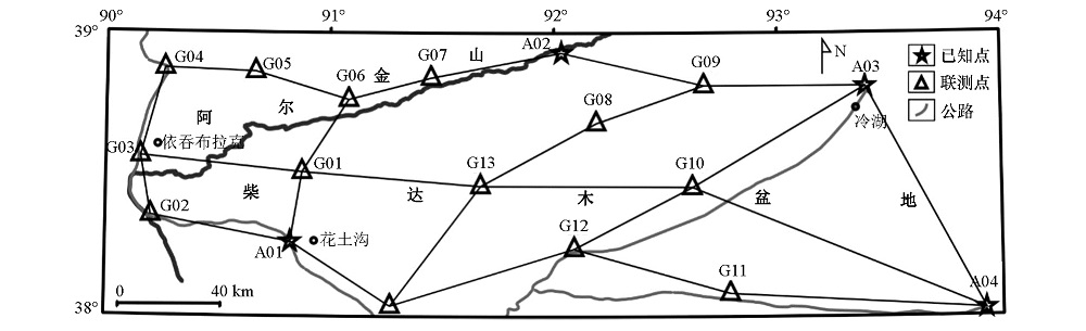
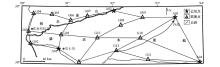
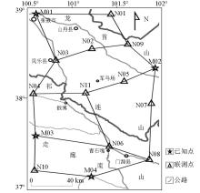
GPS control net sketch alh map of Youdunzi project
|
|
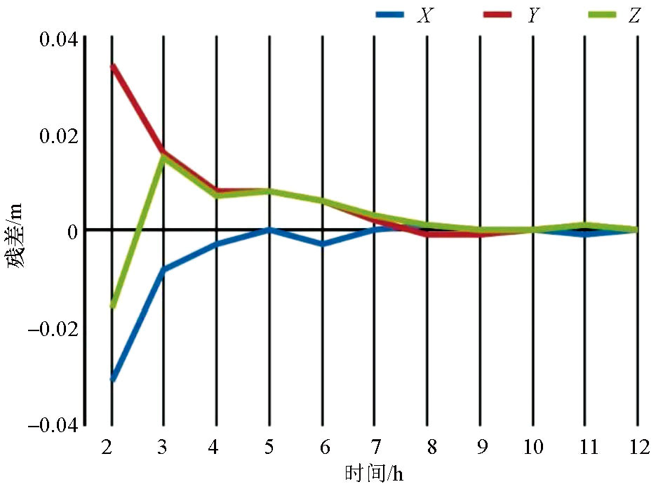
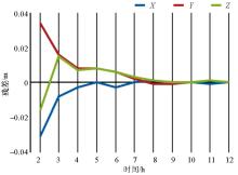
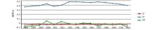
The relation of coordinates converge with observation time
|

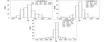
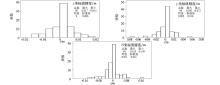
| A01 | A02 | A03 | A04 | G01 | G02 | G03 | G04 | G05 | G06 | G07 | G08 | G09 | G10 | G11 | G12 | G13 | | N | 15 | 4 | 3 | 3 | 3 | 14 | 10 | 4 | 11 | 6 | 4 | 3 | 5 | 12 | 3 | 11 | 3 |
|
The number of data calculated by each control station in Youdunzi project
|
|
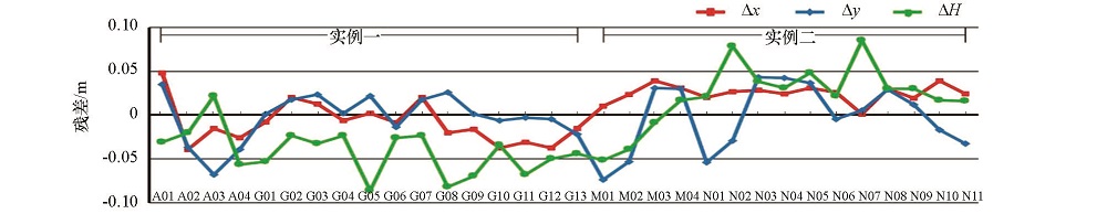
Inner coincidence accuracy of PPP coordinate in first example
|
|
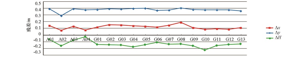
Outer coincidence accuracy of PPP coordinate in first example
|
|
GPS control net sketch alh map of Menyuan project
|
| M01 | M02 | M03 | M04 | N01 | N02 | N03 | N04 | N05 | N06 | N07 | N08 | N09 | N10 | N11 | | N | 4 | 4 | 4 | 11 | 3 | 7 | 15 | 12 | 7 | 3 | 3 | 8 | 3 | 3 | 3 |
|
The number of data calculated by each control station in Menyuan project
|
|
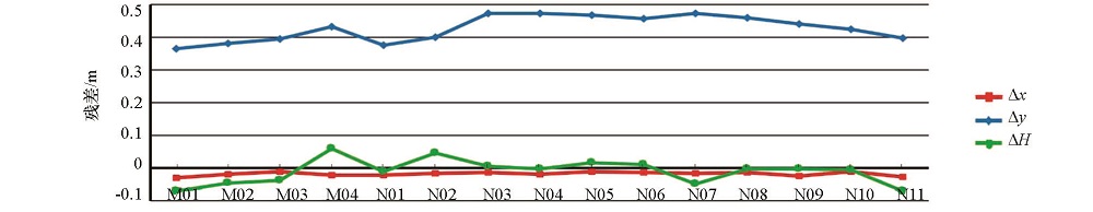
Inner coincidence accuracy of PPP coordinate in second example
|
|
Outer coincidence accuracy of PPP coordinate in second example
|
|
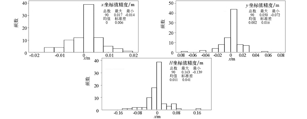
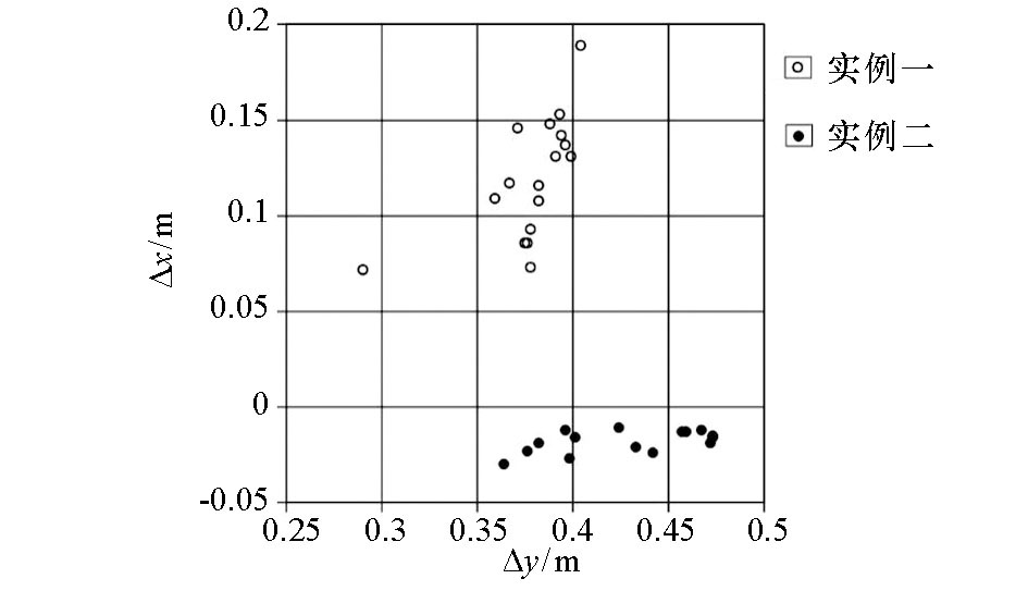
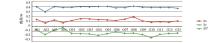
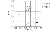
Distribution of outer-coincidence coordinate difference
|
| Vx/(mm·a-1) | Vy/(mm·a-1) | Vz/(mm·a-1) | | 实例一 | -32.6 | -5.8 | 4.7 | | 实例二 | -34.1 | -3.6 | -5.7 |
|
Mean velocities for Epoch correction in project
|
| Tx/mm | Ty/mm | Tz/mm | D/ppb | Rx/mas | Ry/mas | Rz/mas | Eopch | | 4.8 | 2.6 | -33.2 | 2.92 | 0 | 0 | 0.06 | 2000.0 |
|
Conversion parameter of ITRF2008 to ITRF 97
|
|
Outer coincidence accuracy after correction
|
| [1] |
Zumberge J F, Heflin M B, Jefferson D C , et al. Precise point positioning for the efficient and robust analysis of GPS data from large networks[J]. Journal of Geophysical Research, 1997,102(B3):5005-5017.
|
| [2] |
Kouba J, Heroux P . GPS precise point positioning using IGS orbit products[J]. GPS Solution, 2001,5(1):12-28.
|
| [3] |
刘经南, 叶世榕 . GPS非差相位精密单点定位技术探讨[J]. 武汉大学学报:信息科学版, 2002,27(3):234-240.
|
| [3] |
Liu J N, Ye S R . GPS Priecise point positioning using undifferenced phase observation[J]. Geomatics and Information Science of Wuhan University, 2002,27(3):234-240.
|
| [4] |
吴江飞, 黄珹 . GPS精密单点定位模型及其应用分析[J]. 大地测量与地球动力学, 2008,28(1):96-100.
|
| [4] |
Wu J F, Huang C . GPS precise point positioning models and their utility analysis[J]. Journal of Geodesy and Geodynamics, 2008,28(1):96-100.
|
| [5] |
张金宝, 王少闽 . GPS精密单点定位程序设计及实现[J]. 城市勘测, 2009,( 5):61-64.
|
| [5] |
Zhang J B, Wang S M . Programmer of GPS precise point positioning[J]. Urban Geotechnical Investigation Surveying, 2009, ( 5):61-64.
|
| [6] |
阮仁桂, 郝金明, 吕志伟 , 等. GPS双频精密单点定位软件及其精度分析[J]. 测绘科学技术学报, 2009,26(4):276-280.
|
| [6] |
Ruan R G, Hao J M, Lyu Z W , et al. GPS dual-frequency precise point positioning software and accuracy evaluation[J]. Journal of Geomatics Science and Technology, 2009,26(4):276-280.
|
| [7] |
张小红, 李星星, 郭斐 , 等. GPS单频精密单点定位软件实现与精度分析[J]. 武汉大学学报:信息科学版, 2008,33(8):783-787.
|
| [7] |
Zhang X H, Li X X, Guo F , et al. Realization and precision analysis of single-frequency precise point positioning software[J]. Geomatics and Information Science of Wuhan University, 2008,33(8):783-787.
|
| [8] |
鲁洋为, 王振杰 . Bernese 5.0软件下的精密单点定位精度分析[J]. 测绘通报, 2016,( 2):22-25.
|
| [8] |
Lu Y W, Wang Z J . Accuracy analysis of PPP based on GPS software bernese 5.0[J]. Bulletin of Surveying and Mapping, 2016, ( 2):22-25.
|
| [9] |
左廷英, 黄远成, 袁本银 . GPS精密单点定位外符合精度测试[J]. 矿山测量, 2008,( 5):8-11.
|
| [9] |
Zuo T Y, Huang Y C, Yuan B Y . GPS precise point positioning outer coincidence accuracy test[J]. Mine Surveying, 2008, ( 5):8-11.
|
| [10] |
张光茹, 秘金钟 . 不同数据处理策略对PPP收敛精度的影响[J]. 测绘科学, 2018,43(3):77-81.
|
| [10] |
Zhang G R, Mi J Z . Impact analysis of different data processing strategies for PPP convergence accuracy[J]. Science of Surveying and Mapping, 2018,43(3):77-81.
|
| [11] |
王涛涛, 洪伟 . 不同时长GNSS观测数据RTKLib精密单点精度定位研究[J]. 地理信息世界, 2018,25(5):114-117.
|
| [11] |
Wang T T, Hong W . Research on the precision of RTKLib precise point positioning with different duration GNSS data[J]. Geomatics World, 2018,25(5):114-117.
|
| [12] |
耿涛, 赵齐乐, 刘经南 , 等. 基于PANDA软件的实时精密单点定位研究[J]. 武汉大学学报:信息科学版, 2007,32(4):312-315.
|
| [12] |
Geng T, Zhao Q L, Liu J N , et al. Real-time precise point positioning based on PANDA sofeware[J]. Geomatics and Information Science of Wuhan University, 2007,32(4):312-315.
|
| [13] |
韩菲, 张春燕 . Bernese 5.0用于精密单点定位的数据处理及精度分析[J]. 测绘地理信息, 2015,40(6):28-31.
|
| [13] |
Han F, Zhang C Y . Data processing and accuracy analysis in precise point positioning based on bernese 5.0[J]. Journal of Geomatics, 2015,40(6):28-31.
|
| [14] |
谭争光, 郭金运, 宗干 , 等. PANDA和Bernese软件的PPP比较分析[J]. 全球定位系统, 2013,38(5):60-64.
|
| [14] |
Tan Z G, Guo J Y, Zong G , et al. Comparison of PPP between PANDA and bernese[J]. GNSS World of China, 2013,38(5):60-64.
|
| [15] |
李凯锋, 欧阳永忠, 陆秀平 , 等. 基于PPP技术的海岛礁平面控制测量应用实践[J]. 武汉大学学报:信息科学版, 2015,40(3):413-416.
|
| [15] |
Li K F, Ouyang Y Z, Lu X P , et al. Application of precise point positioning for island control survey[J]. Geomatics and Information Science of Wuhan University, 2015,40(3):413-416.
|
| [16] |
崔剑凌 . 精密单点定位技术在困难地区重力调查中的应用[J]. 现代测绘, 2014,37(3):22-24.
|
| [16] |
Cui J L . Application of precise point positioning technique in the investigation of the difficult areas of gravity[J]. Modern Surveying and Mapping, 2014,37(3):22-24.
|
| [17] |
陈俊勇, 杨元喜, 王敏 , 等. 2000国家大地控制网的构建和它的技术进步[J]. 测绘学报, 2007,36(1):1-7.
|
| [17] |
Chen J Y, Yang Y X, Wang M , et al. Establishment of 2000 national geodetic control network of china and its technological process[J]. Acta Geodaetica et Cartographica Sinica, 2007,36(1):1-7.
|
| [18] |
魏子卿, 刘光明, 吴富梅 . 2000中国大地坐标系:中国大陆速度场[J]. 测绘学报, 2011,40(4):403-410.
|
| [18] |
Wei Z Q, Liu G M, Wu F M . China geodetic coordinate system 2000: velocity field in mainland China[J]. Acta Geodaetica et Cartographica Sinica, 2011,40(4):403-410.
|
| [19] |
杜辉, 耿涛, 高鹏 , 等. 适用于青藏高原地区中大比例尺重力勘查的大地测量方法技术研究[J]. 地质与勘探, 2017,53(5):915-922.
|
| [19] |
Du H, Geng T, Gao P , et al. Study on geodetic methods in gravity surveys of medium-large scales applicable to the Tibetan plateau[J]. Geology and Exploration, 2017,53(5):915-922.
|
| [1] |
SHI Zhao-Yang, GAO Wei-Qiang, ZHANG Li-Ming, ZHANG Lin, FENG Xu-Liang, HE Tao, ZHENG You-Wei. Integrated geophysical exploration of the Wei concubine in the Tang-dynasty Zhao Mausoleum[J]. Geophysical and Geochemical Exploration, 2021, 45(6): 1617-1624. |
| [2] |
CAI Sheng. The research on the application of geological prediction technology to Zhangjihuai railway tunnel[J]. Geophysical and Geochemical Exploration, 2021, 45(5): 1275-1280. |
|
|
|
|