|
|
|
| A study of transformation of the coordinate system from geophysical and geochemical results coordinate to CGCS2000 coordinate in ArcGIS |
| Hui DU1,2,3, Tao GENG2,3, Sheng-Rong LIU2,3, Yun BAI2,3 |
1. College of Earth Science and Resources,Chang'an University,Xi'an 710054,China
2. Key Laboratory for the Study of Focused Magmatism and Glantore Deposits,Xi’an 710054,China;
3. Xi’an Center of China Geological Survey,Xi’an 710054,China; |
|
|
|
|
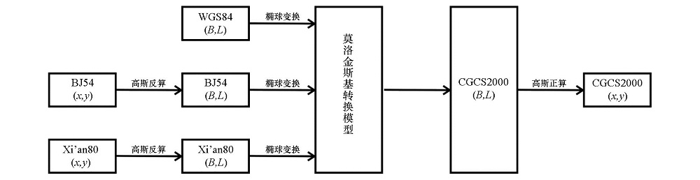
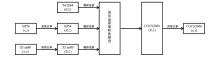
Abstract Due to historical reasons, the present coordinate systems of the geological, geophysical and geochemical exploration results are basically WGS84, BJ54 or XA80 systems; nevertheless, according to the NASG requirements on the overall use of CGCS2000 coordinates, in the future the coordinates for all kinds of results should be CGCS2000 coordinates, which causes inconvenient situation in using the results and in comprehensive research work. As a professional geographic information system software, ArcGIS has a wide range of applications in various walks. In this paper, the authors briefly introduced the ArcGIS built-in coordinate system, studied and deduced the calculation formula of the MOLODENSKY coordinate conversion method in ArcGIS, put forward the method to get the conversion and precision evaluation of transformation parameters between different ellipsoids, and cited practical examples for verification. On such a basis, the specific ideas and points for attention were analyzed for each coordinate system in the conversion of ArcGIS software to CGCS2000.
|
|
Received: 01 December 2017
Published: 24 October 2018
|
|
|
|
|
|

| 坐标系统 | BJ54 | Xian80 | WGS84 | CGCS2000 | | 坐标系类型 | 参心 | 参心 | 地心 | 地心 | | 定向 | 普尔科沃 | 1968极原点 | BIH1984.0定义的协议极原点 | 2000.0的地球参考极方向 | | 椭球基准 | Krasovsky_1940 | IAG75 | WGS84 | CGCS2000 | | 长半轴/m | 6378245 | 6378140 | 6378137 | 6378137 | | 扁率 | 1/298.3 | 1/298.257 | 1/298.257223563 | 1/298.257222101 | | 参考历元 | —— | —— | G1674(2012) | 2000.0 | | 参考框架 | —— | —— | ITRF08 | ITRF97 |
|
|
|
|
|
|

|
|
|
| 点数 | x较差/m | y较差/m | | 最大 | 最小 | 中误差 | 最大 | 最小 | 中误差 | | 100 | 0.203 | -0.178 | 0.103 | 0.196 | -0.184 | 0.076 |
|
|
|
| [1] |
程鹏飞, 文汉江, 成英燕 , 等. 2000国家大地坐标系椭球参数与GRS80和WGS84的比较[J]. 测绘学报, 2009,38(3):189-194.
|
| [2] |
魏子卿 . 2000中国大地坐标系及其与WGS84的比较[J]. 大地测量与地球动力学, 2008,28(5):1-5.
|
| [3] |
史俊莉, 牛鹏涛 . CGCS2000坐标系的推广与应用[J]. 价值工程, 2014,26(2):229-230.
|
| [4] |
赵志军, 冯林刚, 李晶 . CGCS2000坐标系对现有地质成果的影响[J]. 安全与环境工程, 2014,21(3):18-20.
|
| [5] |
杨亚斌, 韩革命, 梁萌 . 2000国家大地坐标系在区域重力调查中的应用探讨[J]. 物探化探计算技术, 2011,33(3):346-349.
|
| [6] |
李克恭, 牛岸英, 张斌才 , 等. CGCS2000对现有国家基本比例尺地图使用精度影响分析[J].工程勘察, 2010(11):67-69.
|
| [7] |
王新春, 王芳, 商云涛 . BJS54、XAS80测绘成果到CGCS2000的转换及图幅拼接方法研究[J]. 中国矿业, 2014,23(s):319-323.
|
| [8] |
郭充, 吕志平 . BJS54测绘成果到CGCS2000的改正分析[J]. 测绘科学技术学报, 2008,25(5):387-390.
|
| [9] |
林吉兆, 贾登科, 武警 . CGCS2000及WGS84坐标系若干问题探讨及应对策略[J].水运工程, 2014(2):27-30.
|
| [10] |
彭小强, 高井祥, 王坚 . WGS84和CGCS2000坐标转换研究[J]. 大地测量与地球动力学, 2015,35(2):219-221.
|
| [11] |
何林, 柳林涛, 许超钤 , 等. 常见平面坐标系之间相互转换的方法研究——以1954北京坐标系、1980西安坐标系、2000国家大地坐标系之间的平面坐标相互转换为例[J]. 测绘通报, 2014,( 9):6-11.
|
| [12] |
王洪战, 马燕燕, 张振涛 , 等. 基于ArcGIS的专题地图制作方法综合研究[J].城市勘测, 2008(4):47-49.
|
| [13] |
刘艳宾, 弓小平, 陈斌 , 等. ArcGIS在东昆仑西段铁矿资源综合信息矿产预测中的应用——以沉积变质型铁矿为例[J]. 地质学报, 2012,86(6):1005-1019.
|
| [14] |
何政伟, 黄润秋, 许强 , 等. 基于ArcGIS的地质灾害防治信息与决策支持系统的研制[J]. 吉林大学学报:地球科学版, 2004,34(4):601-606.
|
| [15] |
孔祥元, 郭际明, 刘宗泉 . 大地测量学基础[M]. 武汉: 武汉大学出版社, 2006, 46-47.
|
| [16] |
武汉大学测绘学院测量平差学科组. 误差理论与测量平差基础[M]. 武汉: 武汉大学出版社, 2003: 102-103.
|
| [17] |
魏子卿, 刘光明, 吴富梅 . 2000中国大地坐标系:中国大陆速度场[J]. 测绘学报, 2011,40(4):403-410.
|
| [18] |
杜辉, 耿涛, 高鹏 , 等. 适用于青藏高原地区中大比例尺重力勘查的大地测量方法技术研究[J]. 地质与勘探, 2017,53(5):915-922.
|
| [1] |
Hui DU, Tao GENG, Xing-Xing DUAN, Xian-Kun JI, Yun BAI. The application of precise point positioning to local geophysical prospecting in the Tibetan Plateau[J]. Geophysical and Geochemical Exploration, 2019, 43(5): 1046-1053. |
| [2] |
HE Hui, XUE Dian-Jun, WANG Lin-Fei. The design and software realization of coordinate transormation for the geophysical data processing and interpretation system[J]. Geophysical and Geochemical Exploration, 2014, 38(5): 1060-1063. |
|
|
|
|