|
|
|
| The application of regional geochemical exploration results to the geological mapping of the North Bayan Har Mountains area, Qinghai Province |
| Guo-Dian BAI1,2, Kai HE1,2, Gen-She JU3, Kun WANG1,2, Yan-Hui WANG1,2, Lan-Lan LI1,2 |
1. Henan Institute of Geological Survey,Zhengzhou 450007,China
2. Key Laboratory of Ore Forming Processes and Resources Utilization of Metal Minerals in Henan Province,Zhengzhou 450007,China
3. Henan Institute of Geological Sciences, Zhengzhou 450007, China |
|
|
|
|
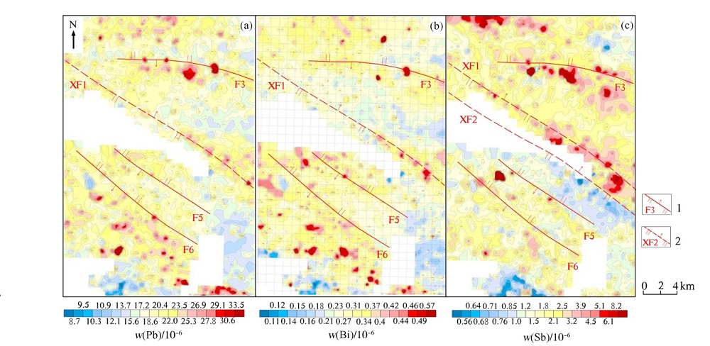
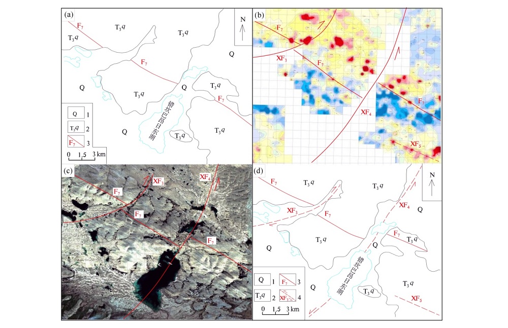
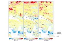
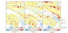
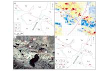
Abstract With the help of regional geochemical exploration results, especially the geochemical maps of different elements, geological interpretation can serve as an important auxiliary means of geological mapping in the North Bayan Mountains, Qinghai Provence, thus significantly improving the mapping efficiency and accuracy. The results show that regular content changes of elements such as some rare elements and rare earth elements like Y, Nb and sulfur group elements as well as iron group elements like Cu, Zn, Cr, Co, and Ni in different units of the Bayan Har Mountain Group can be used as important means in internal stratigraphic division and regional stratigraphic correlation of the Bayan Har Mountain Group. Furthermore, faults can be inferred and mapped; especially hidden faults and regional faults in shallowly-covered areas can be recognized and mapped remarkably effectively by using certain element anomalies with spotted and beaded characteristics along the faults (such as Sb, Hg, Bi and Pb) as well as along the straight boundaries of geochemical divisions (such as Sb, Bi, As and Pb).
|
|
Received: 22 June 2017
Published: 04 June 2018
|
|
|
|
|
|
|
|
|

| 组分 | 岩屑组分含量/% | 基质组分含量/% | 填隙物(胶结物)含量 /% | 火
山岩 | 砂岩 | 硅
质岩 | 泥钙
质岩 | 石英 | 长石 | 方
解石 | 白
云母 | 黑
云母 | 锆石 | 绿
泥石 | 绢
云母 | 菱
铁矿 | 铁质 | 硅质 | 泥质 | 钙质 | 巴
颜
喀
拉
山
群 | 昌
马
河
组 | 砂岩 | 0~5 | 0~16 | 5~20 | 0~23 | 35~70 | 15~35 | | 2~5 | 0~3 | 0~微量 | 0~5 | 0~3 | 0~7 | 0~1 | 0~8 | 0~15 | 0~40 | | 粉砂岩 | | | 0~12 | | 40~65 | 10 | | | | | 5~7 | 0~8 | | | | 5~15 | 0~20 | | 板岩 | | | | | 7~25 | 3~5 | | | | | 0~5 | 15~30 | | 0~3 | | 20~55 | 0~15 | | 千枚岩 | | 0~4 | | | 20~60 | 0~15 | | | | | | 30~55 | | | | | 0~6 | 甘
德
组 | 砂岩 | | 0~3 | 4~10 | 0~10 | 45~70 | 13~40 | | 少量 | 0~少量 | 0~微量 | 0~3 | 0~少量 | | 0~6 | 0~3 | 2~10 | 0~18 | | 粉砂岩 | | | | | 50~70 | 5~8 | | 0~少量 | | | | | 0~8 | | | 7 | 22~30 | 清
水
河
组 | 砂岩 | 0~25 | 0~12 | 10~20 | 4~15 | 25~70 | 12~22 | | 1~3 | 0~4 | | 0~8 | 1~5 | 0~2 | 0~6 | 0~10 | 0~10 | 0~2 | | 钙质粉砂岩 | | | 8~10 | | 33~42 | 8~12 | 16~33 | 微量~1 | | | | 3~12 | | 1~2 | 3~4 | 7~10 | 0~4 | | 粉砂岩 | | | 10~18 | | 35~65 | 10~20 | 0~15 | 微量~1 | 0~少量 | | 4~7 | 5~12 | | 1~3 | 5 | 10~15 | |
|
|
|
|
|
|
|
|
|
|
|
|
| [1] |
Green P M . Digital image processing of integrated geochemical and geological information[J]. Journal of the Geological Society of London, 1984,141(5):941-949.

|
| [2] |
Steenfelt A . Geochemical patterns mapping and prospecting Green land in a review of results and experience[J]. Journal of Geochenical Exploration, 1987(1-3):183-205.
|
| [3] |
Steenfelt A . Geochemical patterns related tomajor tectono-strati-graphic units in procambrian of northern Scandinavia and Green land[J]. J. Geochem.Explor., 1990,39:35-48.
|
| [4] |
张文秦, 汪彩芳, 刘成东 , 等. 依据化探成果对东昆仑地质背景的讨论[J]. 现代地质, 2002,16(3):257-262.
|
| [5] |
史长义, 任院生 . 区域化探资料研究基础地质问题[J]. 地质与勘探, 2005,41(3):53-58.
|
| [6] |
樊培林, 王北颖, 王晓云 , 等. 1∶20 万区域化探在解决基础地质问题中的应用———以内蒙古东部喜桂图旗幅为例[J]. 陕西地质, 2007,25(1):64-72.
|
| [7] |
徐国志, 徐锦鹏, 段玲玲 . 化探资料在地质填图中的应用[J]. 物探与化探, 2015,39(3):450-455.
|
| [8] |
刘德鹏, 丁峰, 汤正江 . 区域化探在森林沼泽区地质填图应用初探[J]. 物探与化探, 2004,28(4):209-217.
|
| [9] |
时艳香, 纪宏金, 郝立波 , 等. 利用水系沉积物地球化学数据判别浅覆盖区岩性与构造——欧氏距离法[J]. 物探化探计算技术, 2004,26(3):243-246.
|
| [10] |
时艳香, 郝立波, 陆继龙 , 等. 因子分类法在黑龙江塔河地区地质填图中的应用[J]. 吉林大学学报:地球科学版, 2008,38(5):899-903.
|
| [11] |
马晓阳, 白显清, 臧晓凡 , 等. 黑龙江沙兰站幅森林沼泽区基础地质调查中的区域化探新方法[J]. 物探与化探, 2005,29(2):108-110.
|
| [12] |
王保林, 翁士明, 汤正江 . 应用多元素背景判断法在浅覆盖区进行1∶20万地质填图的尝试[J]. 安徽地质, 2005,15(4):294-297.
|
| [13] |
郝立波, 陆继龙, 李龙 , 等. 区域化探数据在浅覆盖区地质填图中的应用方法研究[J]. 中国地质, 2007,34(4):710-715.
|
| [14] |
赵玉岩 . 区域地球物理地球化学资料在浅覆盖区地质调查中的应用方法研究[D]. 长春:吉林大学, 2009.
|
| [15] |
吴俊, 卜建军, 谢国刚 . 区域化探数据在华南强烈风化区地质填图中的应用[J]. 地质力学学报, 2016,22(4):954-966.
|
| [16] |
青海省地质矿产局. 格尔木东农场幅、东温泉幅1∶20万区域地质调查报告(地质部分)[R]. 1983.
|
| [17] |
青海省地质矿产局. 错坎巴昂日东幅1∶20万区域地质调查报告(地质部分)[R]. 1993.
|
| [18] |
吴珍汉, 叶培盛, 胡道功 , 等. 青藏高原羌塘盆地南部古近纪逆冲推覆构造统[J]. 地质通报, 2011,30(7):1009-1016.
|
| [19] |
王立全, 潘桂棠, 丁俊 , 等. 青藏高原及邻区地质图及说明书(1∶1500000)[M]. 北京: 地质出版社, 2013.
|
| [20] |
李宾, 李随民, 杨传祥 , 等. 地质体方法圈定化探异常——以张家口某地区为例[J]. 地质找矿论丛, 2011,26(2):212-216.
|
| [21] |
李随民, 魏明辉, 郝华金 . 消除背景影响的化探异常圈定方法——以张家口地区为例[J]. 中国地质, 2014,41(6):2083-2090.
|
| [22] |
赵澄林, 朱筱敏 . 沉积岩石学[M]. 北京: 石油工业出版社, 2000.
|
| [23] |
郝立波, 李巍, 陆继龙 . 确定岩性复杂区的地球化学背景与异常的方法[J]. 地质通报, 2007,26(12):1531-1535.
|
| [24] |
荣发准, 张彦霞, 孙长青 , 等. 合肥盆地不同背景下化探异常的变化规律[J]. 物探与化探, 2004,28(5):433-435.
|
| [25] |
周永恒, 李守义, 张璟 . 基于地质背景分析的区域化探数据系统误差校正[J]. 吉林大学学报:地球科学版, 2011,41(3):753-758.
|
| [26] |
蒋敬业, 程建萍, 祁士华 , 等. 应用地球化学[M]. 武汉: 中国地质大学出版社, 2006, 1-340.
|
| [27] |
韩吟文, 马振东, 张宏飞 , 等. 地球化学[M]. 北京: 地质出版社, 2003.
|
| [1] |
Guo-Shuai GENG, Fan YANG, Jian-Na GUO. The application of ILR transromed data factor analysis to delineating geochemical anomalies[J]. Geophysical and Geochemical Exploration, 2020, 44(1): 112-121. |
| [2] |
Shao-Bing TIAN, Xiang-Qian LI, Tong-Xiao SHANG, Jian OU, Da-Lian ZHANG. The application of direct-current sounding method in the coastal plains: A case study of Guanyun area in Lianyungang[J]. Geophysical and Geochemical Exploration, 2019, 43(4): 783-793. |
|
|
|
|