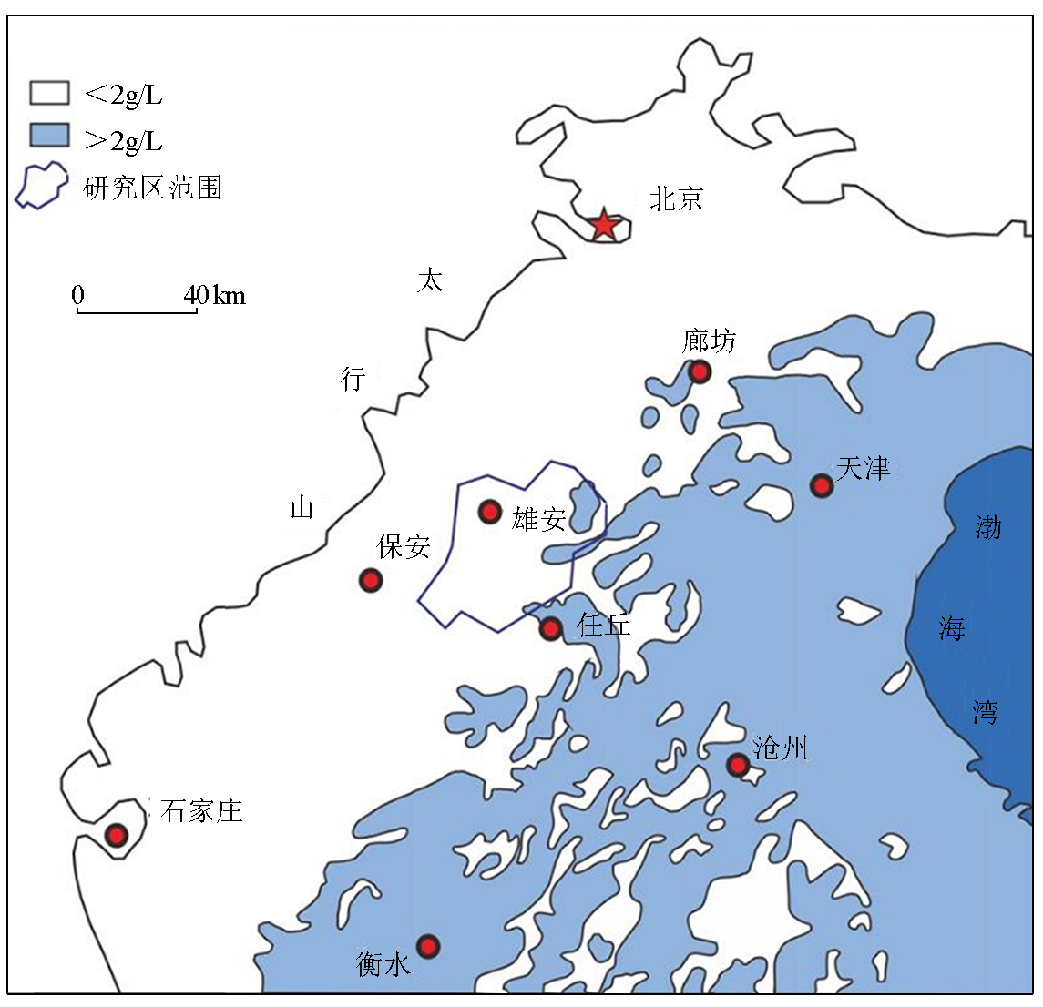
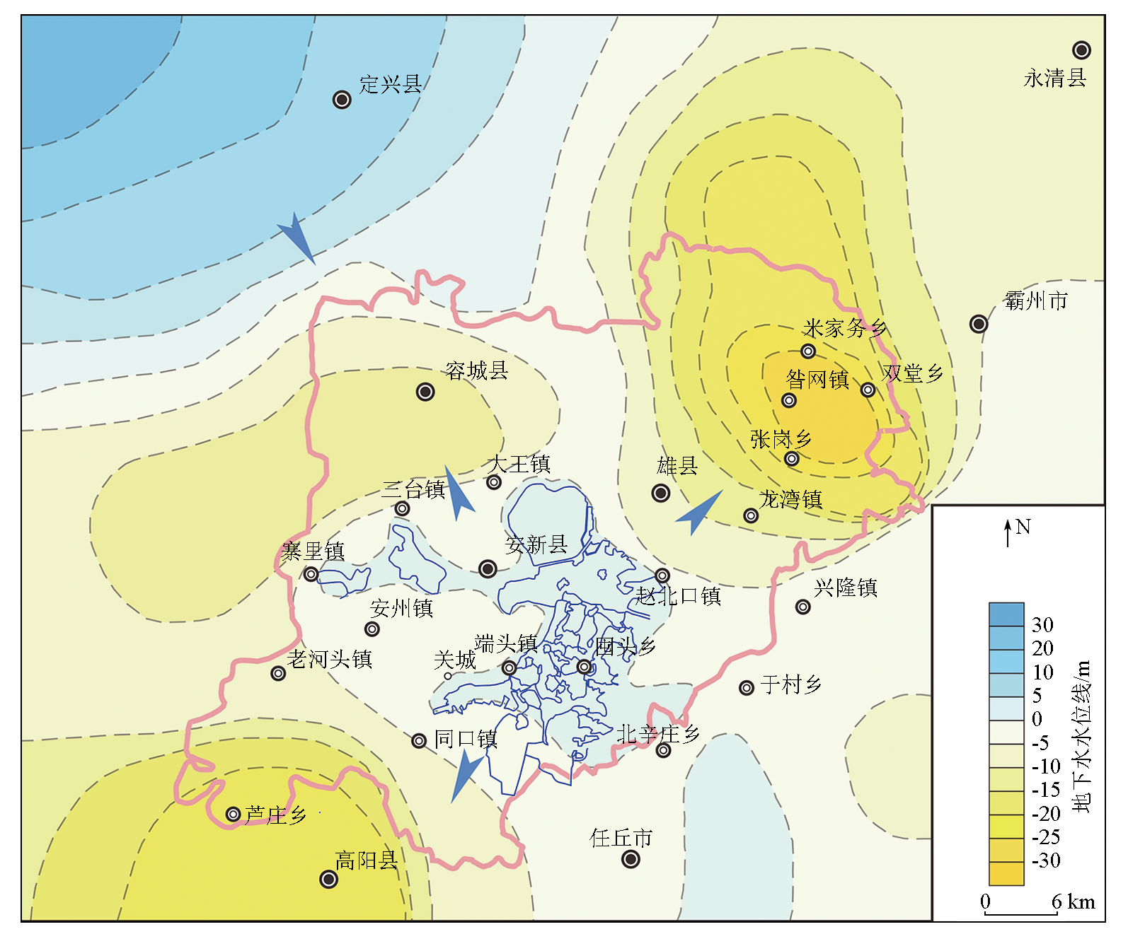
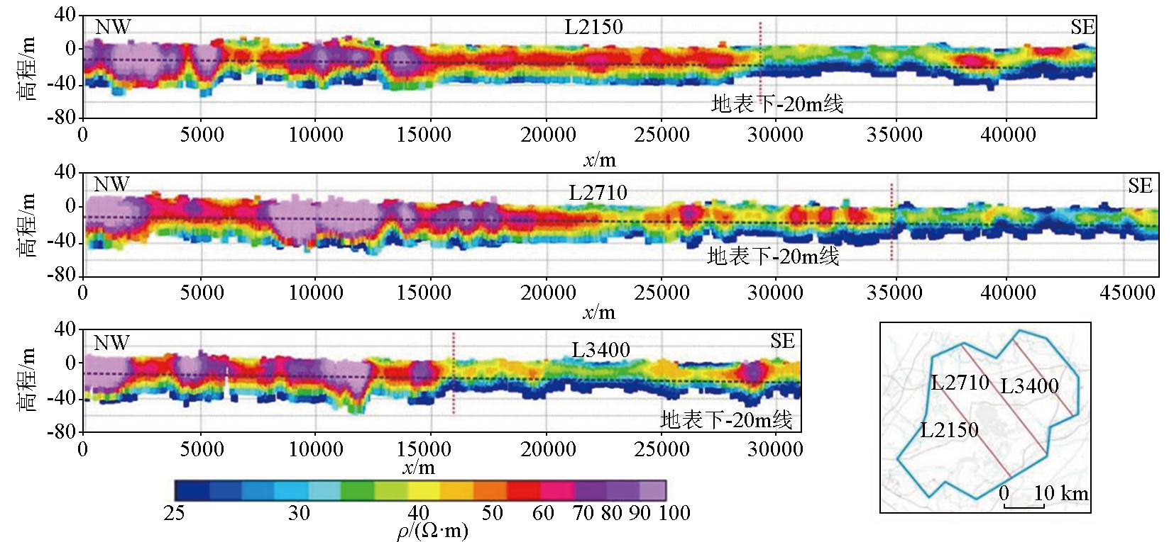
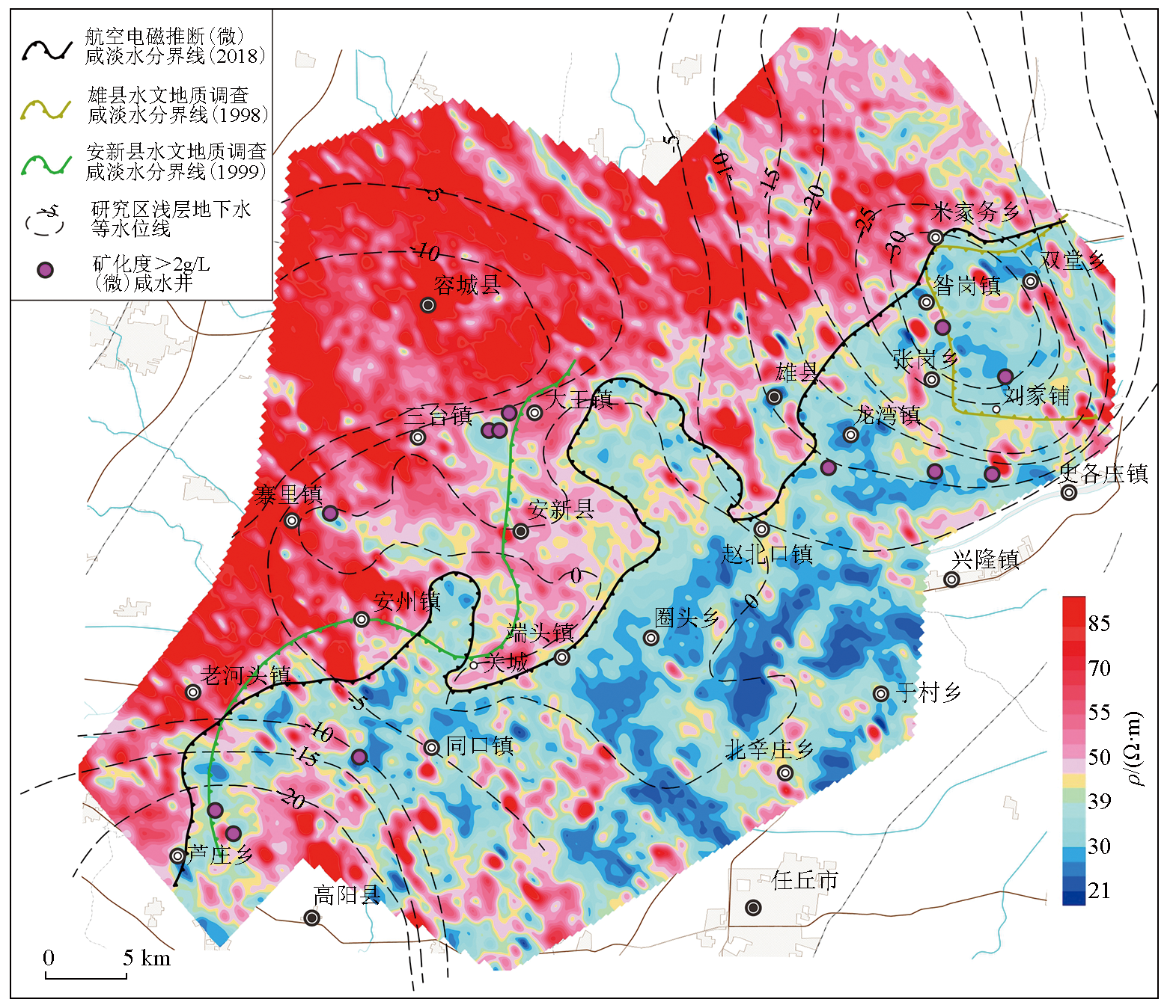
Determining the boundary between shallow saline water and freshwater in areas containing (brackish) saline water can guide the exploitation and utilization of local shallow water resources. This study analyzed the characteristics of underground shallow electrical structure through inversion based on the frequency-domain airborne electromagnetic data. Then, it inferred the boundary between the shallow (brackish) saline water and freshwater in the study area. By comparison with the boundaries between saline water and freshwater obtained from two hydrological surveys in 1998 and 1999 and by combining the surface hydrogeological data, this study revealed that the shallow groundwater cones of depression affect saline water intrusion trends in the Xiong’an New Area, and the details are as follows: The (brackish) saline water intrusion in the Zangang-Mijiawu-Shuangtang area in the northeast of Xiongxian County tends to be stable due to the presence of the Zangang groundwater cone of depression. However, this cone has also intensified the (brackish) saline water intrusion in southern Zangang Town. Compared to 1999, the (brackish) saline water range on the west side of Anxin County has continuously decreased due to the rise in the water level of the Rongcheng groundwater cone of depression. The continuous decrease in the water level of the Gaoyang groundwater cone of depression determines that the (brackish) saline water range in the Luzhuang-Gaoyang direction will continuously expand. These predicted (brackish) saline water intrusion trends will provide data support for the rational exploitation and utilization of water resources in the construction of the Xiong'an New Area.
单希鹏, 谢汝宽, 余学中, 梁盛军, 李健. 频率域航空电磁法在雄安新区浅层(微)咸淡水调查中的应用[J]. 物探与化探, 2023, 47(2): 504-511.
SHAN Xi-Peng, XIE Ru-Kuan, YU Xue-Zhong, LIANG Sheng-Jun, Li Jian. Application of the frequency-domain airborne electromagnetic method in shallow (brackish) saline water and freshwater surveys in the Xiong'an New Area. Geophysical and Geochemical Exploration, 2023, 47(2): 504-511.
Pang G B, Zhang L Z, Cong X, et al. Leaf photosynthesis and light response curve simulation of winter wheat under brackish water irrigation[J]. Transaction of the Chinese Society for Agricultural Machine, 2021, 52(11):333-342.
Yang G K, Wu Y F, Cao H H, et al. Effects of organic compound substrate from corn stalk tomato growth and fruit quality under brackish and fresh water irrigation[J] .Acta Agriculturae Boreali-Sinica, 2021, 36(S):81-88.
Feng D, Zhang J P, Cao C Y, et al. Optimal irrigation method in pre-sowing irrigation with saline water and determination of mineralization degree index for cotton seedling[J]. Transactions of the Chinese Society of Agricultural Engineering, 2014, 30(22):95-101.
Wang G E, Guo L, Qian Y Y, et al. Effects of different s aline water irragation on chlorophyll fluores cence parameters in cotton and the soil s alt content[J]. Cotton Science, 2021, 33(1):13-21.
Guo R S, Lin T, Xu H J, et al. Effect of saline water drip irrigation on water and salt transport features and cotton yield of oasis cotton field[J]. Journal of Soil and Water Conservation, 2017, 31(1):211-216.
Ma Z B, Tan J L, Wei T. The Variation of salt-tolerance of crops in different regions irrigated with brackish water in China[J]. Journal of Irrigation and Drainage, 2019, 38(3):70-75.
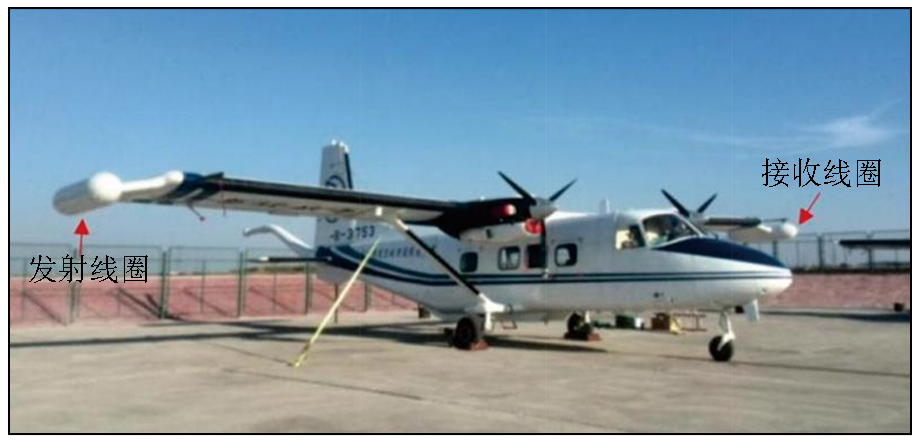
Wang W P, Zhou X H, Fan Z G, et al. Demonstration application of towered bird helicopter-borne electromagnetic technique[J]. Geological Survey of China, 2015, 2(5):1-7.
Wang W P, Yu X Z, Guo H, et al. Hydrological engineering environmental airborne geophysical technique and its application[M]. Beijing: Geological Publishing House, 2021.
Man Y L. Investigation of shadow water resources using frequency domain aeroelectromagentic method[J]. Chinese Journal of Geophysics, 1990, 33(5):604-610.
Meng Q M. Preliminary achievements obtained by Y11B aerogeophysical (electric / magnetic) integrated station in water exploration of northwest China[J]. Geophysical and Geochemical, 1998, 22(4):241-246.
Wang W P, Wang Y S. The application of airborne electromagnetic method to the exploration of shadow fresh water at the mouth area of the Yellow River[J]. Geophysical and Geochemical, 1999, 23(2):115-121,127.
[13]
Lipinski B A, Sams J I, Smith B D, et al. Using HEM surveys to evaluate disposal of by-product water form CBNG development in the Powder River Basin,Wyoming[J]. Geophysics, 2008, 73(3):B77-B84.
doi: 10.1190/1.2901200
[14]
Siemon B, Christiansen A V, Auken E. A review of helicopter-borne electromagnetic methods for groundwater exploration[J]. Near Surface Geophysics, 2009,7,629-646.
[15]
Chandra S, Tiwari V M, Vidyasagar M, et al. Airborne electromagnetic signatures of an ancient river in the water-stressed Ganga plain,Prayagraj,India:A potential groundwater repository[J]. Geophysical Research Letters, 2021, 48(23): e2021GL096100.
[16]
Jorgensen F, Scheer W, Thomsen S, et al. Transboundary geophysical mapping of geological elements and salinity distribution critical for the assessment of future sea water intrusion in response to sea level rise[J]. Hydrology and Earth System Sciences, 2012, 16:1845-1862.
doi: 10.5194/hess-16-1845-2012
[17]
Gunink J L, Bosch J H, Siemon B, et al. Combining ground-based and airborne EM through artificial neural networks for modelling glacial till under saline groundwater conditions[J]. Hydrology and Earth System Sciences, 2012, 16:3061-3074.
doi: 10.5194/hess-16-3061-2012
[18]
Gottschalk I, Knight R, Asch T, et al. Using an airborne electromagnetic method to map saltwater intrusion in the northern Salinas Valley,California[J]. Geophysics, 2019, 85(4):B119-B131.
doi: 10.1190/geo2019-0272.1
Qian Y, Zhang Z J, Fei Y H, et al. Sustainable exploitable potential of shallow groundwater in the North China Plain[J]. Chinese Journal of Eco-Agriculture, 2014, 22(8):890-897.
Liu Y Q, Zhou L, He J, et al. Research status and trend of shadow brackish exploration in North China Plain[J]. Journal of Irrigation and Drainage, 34(S1):137-141.
Fang S, Dai W Y. Control and utilization of rainwater in salline groundwater region of North China Plain[J]. South to North Water Transfers and Water Science & Technology, 2003, 1(1):38-43.
[22]
河北省环境地质勘查院. 河北雄县区域水文地质调查报告[R]. 1998.
[22]
Hebei Survey Institute of Environmental Gelogy. Regional hydrogeological survey report of Xiongxian County,Hebei Province[R]. 1998.
[23]
河北省环境地质勘查院. 河北安新县县区域水文地质调查报告[R]. 2000.
[23]
Hebei Survey Institute of Environmental Gelogy. Regional hydrogeological survey report of Anxin County,Hebei Province[R]. 2000.
Zhao B L, Ma Z H, Zhao J Y. Analysis of the characteristics of hydrological factors in Xiong'an New Area[J]. Water Sciences and Engineering Technology, 2018(3):47-49.
Ma Y, Li H Q, Zhang J, et al. Geophysical technology for underground space exploration in Xiong’an New Area[J]. Chinese Journal of Geophysics, 2020, 41(4):535-542.
Feng W, Chu X F, Li H T, et al. Wavelet analysis between groundwater level regimes and precipitation,north pacific index in the Xiong’an New Area[J]. Hydrogeology & Engineering Geology, 2017, 44(6):1-8.
Ma Z, Xia Y B, Li H T, et al. Analysis of natural resources and environment eco-geological conditions in the Xiong'an New Area[J]. Geology in China, 48(3):677-696.
Yuan R Q, Long X T, Wang P, et al. Renewal rate of groundwater in the Baiyangdian Lake Basin[J]. Progress in Geography, 2015, 34(3):381-388.
doi: 10.11820/dlkxjz.2015.03.013
[29]
Auken E, Christiansen A V. Layered and laterally constrained 2D inversion of resistivity data[J]. Geophysics, 2004, 69(3):752-761.
doi: 10.1190/1.1759461
Cai J, Qi Y F, Yin C C. Weighted laterally-constrained inversion of frequency-domain airborne EM data[J]. Chinese Journal of Geophysics, 2014, 57(1):953-960.
[31]
Christiansen A V, Auken E. A global measure for depth of investigation[J]. Geophysics, 2012, 77(4):WB171-WB177.
doi: 10.1190/geo2011-0393.1
Zhao J L, Zhang X X, Li Z D, et al. Application of electrical survey in the division of salt and fresh water in groundwater[J]. China Steel Focus, 2020, 15:108-110.