Terrain correction technology for airborne gamma-ray spectrometry based on DEM data
XU Rui1,2(), DENG Zhi-Peng1,2, WEN Long1,2, YU Peng1,2, LI Yuan-Dong1,2, GE Liang-Quan1,2()
1. College of Nuclear Technology and Automation Engineering, Chengdu University of Technology, Chengdu 610059, China 2. Sichuan Provincial Key Laboratory of Geoscience and Nuclear Technology, Chengdu 610059, China
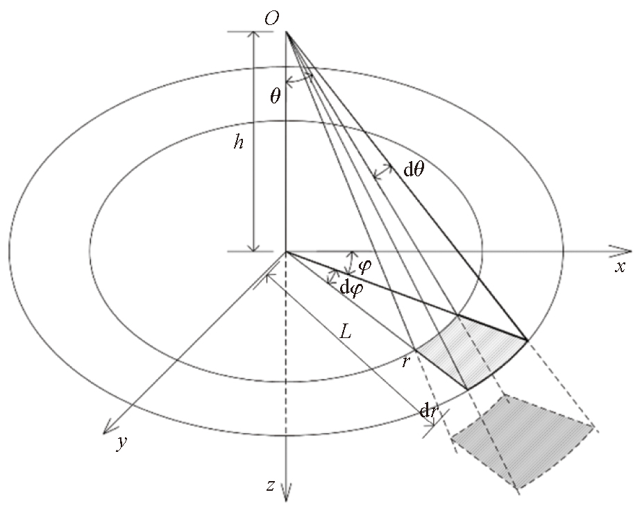
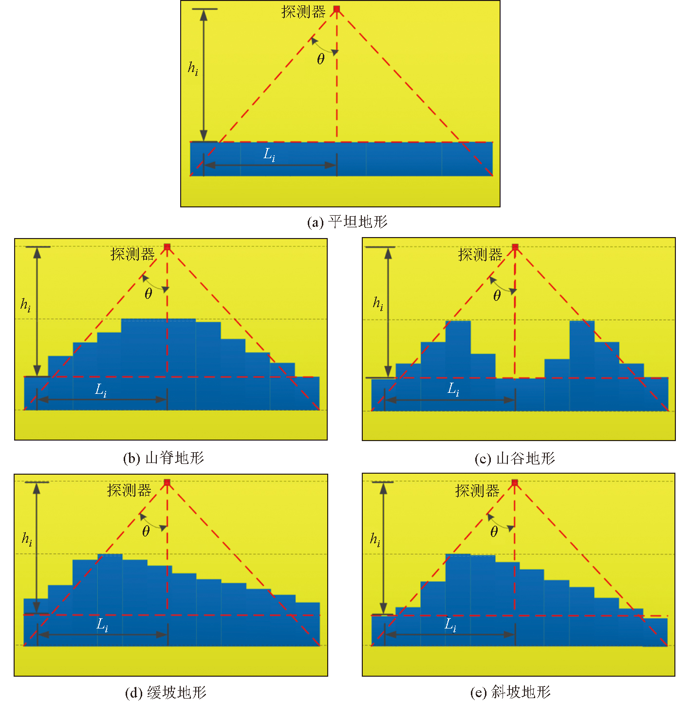
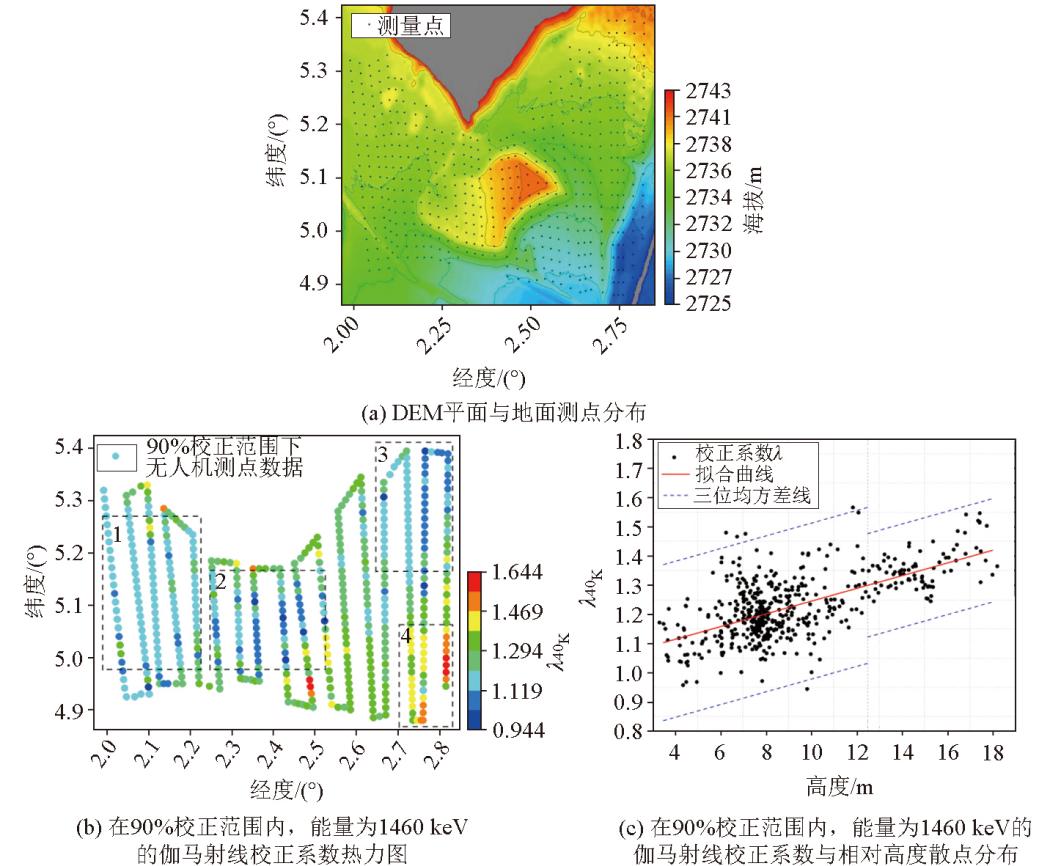
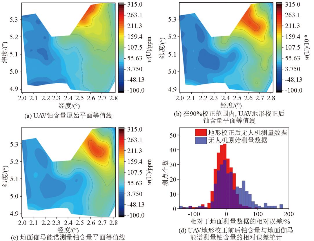
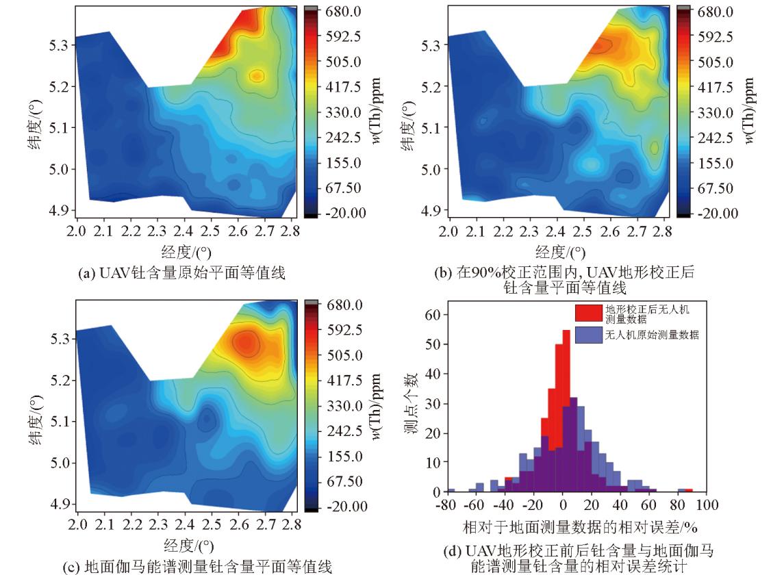
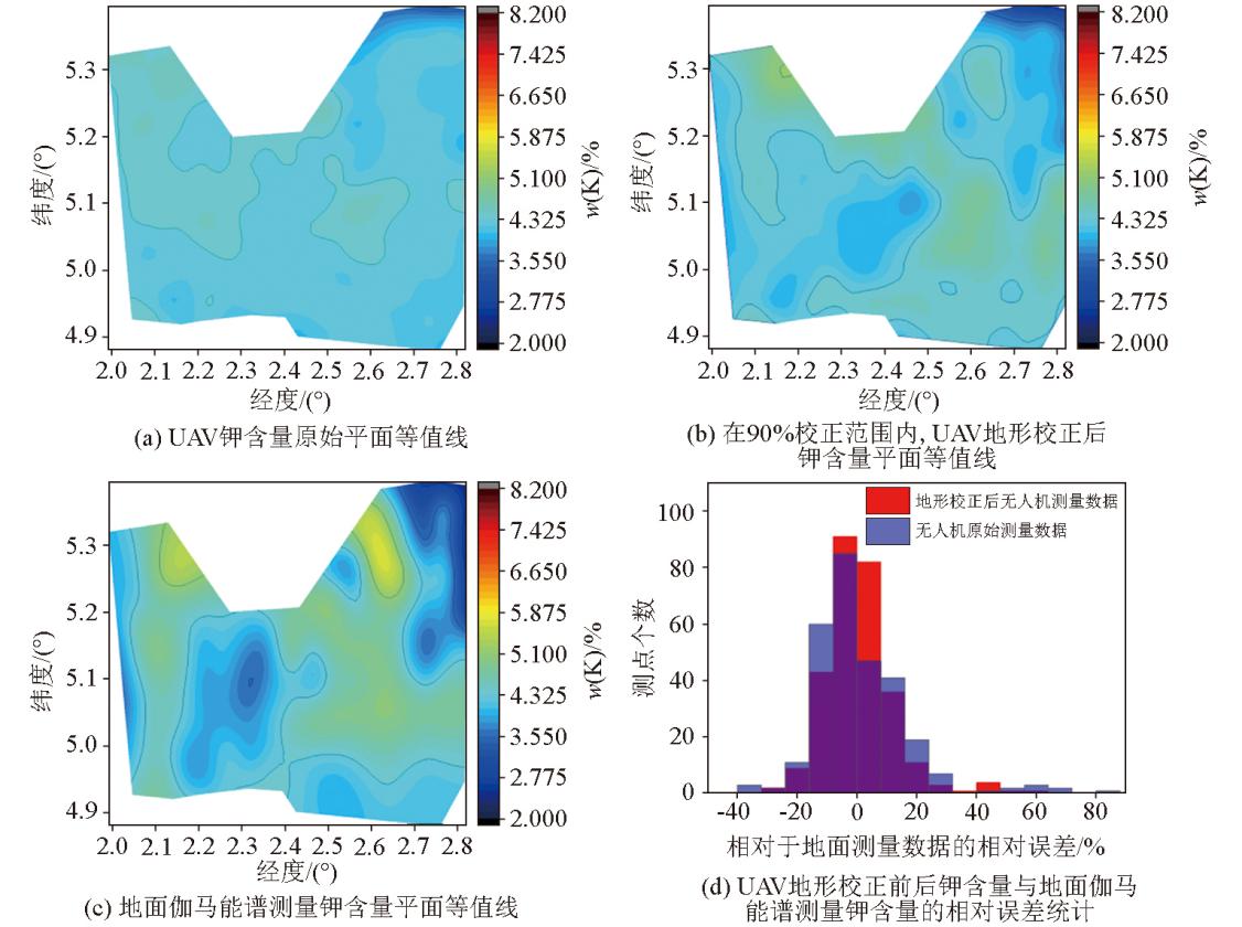
Aerial gamma spectroscopy measurement has important application value in mineral geological exploration, environmental radiation monitoring, and nuclear emergency response due to its advantages of high efficiency, flexibility, and avoidance of personnel radiation exposure risks. With the rapid development of drone technology, drones equipped with gamma-ray spectrometers have become a more flexible and cost-effective low altitude measurement method. However, drones typically fly at low altitudes below 40 meters, and complex terrain can significantly affect the solid angles of detection and the attenuation of gamma rays in the air, thereby reducing the accuracy of measurement results. This article proposes a terrain correction method for unmanned aerial vehicle (UAV) gamma spectroscopy measurement based on digital elevation model (DEM) data, targeting typical complex terrains such as mining pits, stepped mining faces, ore piles, and waste rock piles in open-pit rare earth mines. By establishing a micro element detection factor model and combining it with finite element discretization algorithm, quantitative correction of terrain undulations in the detection area can be achieved. The Monte Carlo simulation and field measurement results show that this method can effectively control the gamma ray intensity response error of terrain such as ridges, valleys, gentle slopes, and slopes within 10%, significantly improving the data quality of low altitude drone gamma spectrum measurement. The unmanned aerial vehicle (UAV) airborne gamma spectroscopy measurement in the open-pit mining area of rare earth mines shows that the relative error between the element content measured by UAV airborne gamma spectroscopy after terrain correction in the measurement area and the weighted average element content measured by surface gamma spectroscopy within 90% correction range is within 30% of the number of points, and the uranium content has increased from 53.2% without terrain correction to 74.3%; The thorium content has increased from 80.3% without terrain correction to 93.3%; The potassium content has increased from 94.7% without terrain correction to 97.2%. The terrain correction method has been verified to have strong practicality and reliability.
Zhang X, Li J K, Wang P J, et al. Progress and prospects of airborn geophysical technology application in sandstone type uranium exploration in China[J]. Computing Techniques for Geophysical and Geochemical Exploration 2025, 47 (4):487-496.
[2]
葛良全, 熊盛青. 航空伽马能谱探测技术与应用[M]. 北京: 科学出版社, 2016.
[2]
Ge L Q, Xiong S Q. Airborne gamma ray spectrum detection and applications[M]. Beijing: Science Press, 2016.
Wan J H, Xiong S Q, Fan Z G. The comparative study to terrain correction method of airborne gamma-ray spectrometry and its application[J]. Progress in Geophysics 2011, 26 (2):641-646.
[4]
Rosa de Almeida G, Coimbra Horbe A M, Peixoto S F, et al. Regolith mapping using airborne gamma-ray spectrometry in central Brazil[J]. Journal of South American Earth Sciences, 2024, 140:104925.
doi: 10.1016/j.jsames.2024.104925
[5]
Tourlière B, Perrin J, Le Berre P, et al. Use of airborne gamma-ray spectrometry for kaolin exploration[J]. Journal of Applied Geophysics, 2003, 53 (2):91-102.
doi: 10.1016/S0926-9851(03)00040-5
Wu J T, Ge L Q, Xiong M L, et al. Characteristic parameters and image enhancement processing of airborne gamma-ray spectrometry survey in uranium exploration[J]. Journal of Chengdu University of Technology:Natural Sciences Edition, 2025, 52 (1):31-43.
Xiong S Q, Mao J W, Liu M, et al. Development strategy of airborne geophysical exploration technology[J]. Strategic Study of Chinese Academy of Engineering 2024, 26 (5):104-116.
[8]
Macfarlane J W, Payton O D, Keatley A C, et al. Lightweight aerial vehicles for monitoring,assessment and mapping of radiation anomalies[J]. Journal of Environmental Radioactivity, 2014, 136:127-130.
doi: 10.1016/j.jenvrad.2014.05.008
[9]
Martin P G, Payton O D, Fardoulis J S, et al. The use of unmanned aerial systems for the mapping of legacy uranium mines[J]. Journal of Environmental Radioactivity, 2015, 143:135-140.
doi: S0265-931X(15)00031-4
pmid: 25771221
[10]
Parshin A, Morozov V, Snegirev N, et al. Advantages of gamma-radiometric and spectrometric low-altitude geophysical surveys by unmanned aerial systems with small scintillation detectors[J] .Applied Sciences, 2021, 11(5):2247.
doi: 10.3390/app11052247
[11]
Amestoy J, Meslin P Y, Richon P, et al. Effects of environmental factors on the monitoring of environmental radioactivity by airborne gamma-ray spectrometry[J]. Journal of Environmental Radioactivity, 2021, 237:106695.
doi: 10.1016/j.jenvrad.2021.106695
[12]
Vander V S, Limburg J, Koomans R L, et al. Footprint and height corrections for UAV-borne gamma-ray spectrometry studies[J]. Journal of Environmental Radioactivity, 2021, 231:106545.
doi: 10.1016/j.jenvrad.2021.106545
[13]
Vander V S, Limburg J, Koomans R L, et al. Optimizing gamma-ray spectrometers for UAV-borne surveys with geophysical applications[J]. Journal of Environmental Radioactivity, 2021, 237:106717.
doi: 10.1016/j.jenvrad.2021.106717
[14]
Altfelder S, Preugschat B, Matos M, et al. Upscaling ground-based backpack gamma-ray spectrometry to spatial resolution of UAV-based gamma-ray spectrometry for system validation[J]. Journal of Environmental Radioactivity, 2024, 273:107382.
doi: 10.1016/j.jenvrad.2024.107382
[15]
Xia J, Song B, Gu Y, et al. Application of advanced spectral-ratio radon background correction in the UAV-borne gamma-ray spectrometry[J]. Nuclear Engineering and Technology, 2023, 55(8):2927-2934.
doi: 10.1016/j.net.2023.04.034
Liu Q S, Zhang Q X, Yang H, et al. Research on terrain correction method of airborne γ spectrometry[J]. Nuclear Techniques 2021, 44(9):76-83.
[17]
Deng Z P, Ge L Q, Wen L, et al. Height and terrain correction of UAV radioactive measurements based on DEM data[J]. Journal of Environmental Radioactivity, 2025, 285:107655.
doi: 10.1016/j.jenvrad.2025.107655