

0 引言
随着城市化、工业化、现代化的快速发展,越来越多含重金属的废水和废弃物被排入水体中,对河流、湖泊等生态系统造成严重威胁[1-2]。重金属具有不易降解、累积性强、生物毒性或生态毒性大等特征[3]。经各种方式进入河流中的重金属大部分通过吸附、沉降等方式转移至底泥中[4-5],而当环境发生变化时,富集在底泥中的重金属可能又会被释放至河流中,对水体质量造成“再次污染”[6],对生态环境系统造成直接或间接的危害,并通过食物链的放大作用对人类健康造成严重威胁[7⇓-9]。因此,底泥重金属污染问题已引起了国内外学者的广泛关注和研究[10⇓⇓-13]。当前,关于底泥重金属污染的评价方法较多,如内梅罗综合指数法[14-15]、地累积指数法[16-17]、污染负荷指数法[18]和潜在生态风险指数法[19-20]等。由于每种评价方法都有各自的优缺点和适用范围[21],所以采用多种方法进行对比和综合分析显得十分具有必要性,各方法可互相借鉴补充,使评价结果更为科学、准确。
长江流域是我国最宝贵的生态资源之一,其生态文明建设是该流域可持续发展的关键。长江的污染与生态环境质量下降势必制约长江经济带的发展与建设,其水体底泥的重金属污染值得引起社会的关注。近年来,有关长江流域底泥重金属的分布特征、风险评价和来源分析等已有学者进行过研究。易雨君等[22]对长江中下游流域重点断面及湖泊的底泥进行了调查研究,发现Cd、Hg、Cr、Pb、Cu、As 和Zn在部分样点中含量均高于背景值,在湖泊、港口和城市化较高的区域表现出明显的富集趋势。杨帆等[15]在对长江中游流域的湖南省主要水系底泥的研究中发现,该流域重金属Cd和Mn含量超过了湖南省表层沉积物重金属元素背景值,污染相对严重,多种重金属具有相同污染来源或产生了复合污染,总体潜在生态风险属于中等级别。但目前关于长江上游的底泥重金属研究较少,尤其是金沙江流域。本文以金沙江南岸支流龙川江的一级支流蜻蛉河流域为研究区,通过分析底泥中8种重金属元素(As、Cd、Cr、Cu、Hg、Ni、Pb、Zn)的含量和沿途分布特征,运用相关性分析、主成分分析的方法探究底泥中重金属的可能来源,运用地累积指数法和内梅罗指数法对底泥的重金属污染程度进行分析与评价,以期为金沙江流域的重金属污染防治和流域生态保护提供基础数据和参考依据。
1 材料与方法
1.1 研究区域概况与样品采集
蜻蛉河发源于云南省楚雄彝族自治州姚安县太平镇黎梅山,向南流入姚安县平坝农业区,后经大姚县向东北方向在元谋县黑泥坡村汇入龙川江[23]。蜻蛉河全长132 km,流域面积达3 546 km2,属亚热带季风气候,总体气候特征冬夏季短、春秋季长,干湿季明显,无霜期长。日温差大、年温差小,年均气温15.6 ℃。雨季主要集中在7~10月,年均降水796.3 mm。研究区地处青藏高原东南缘哀牢山—金沙江断裂带东侧和扬子板块西缘楚雄凹陷带内[24],地貌上表现为以高中山和低山丘陵为主的格局。土壤类型以紫色土、黄棕壤、水稻土为主,在干热河谷区发育有燥红土。研究区内出露的地层主要为侏罗系、白垩系地层以及第四系沉积物[25],河流两岸出露沉积岩岩性主要为中生代红层的紫红色砂岩、泥岩和第四系冲积物,在河流源头处出露小面积的碱性岩浆岩。罗晨皓等[26]发现附近的姚安老街金矿和铅矿等多金属矿床与出露的碱性岩浆岩具有密切关系,由此发现,姚安老街富碱斑岩区多金属矿床的开采可能是导致河流重金属富集的重要原因。河流流经姚安县平坝农耕区和大姚县城区,还可能受到工农业废水污染导致重金属富集。
为了能较好地反映蜻蛉河底泥的重金属富集情况,考虑到流域的水文条件、采样点的可到达性以及样品的代表性等实际情况,在研究区共选取22个代表性断面布设底泥采样点(图1)。为了减少样品的随机误差产生的影响,每个采样点采集4~5个子样等量混合组成1件样品,采样深度为0~20 cm。将采集后的样品放于室内自然风干,过程中确保样品未受到污染,去掉杂草、砾石、动物残体等杂物,用玛瑙碾钵把样品磨碎,过100目尼龙筛后装入聚乙烯塑料瓶保存。
图1
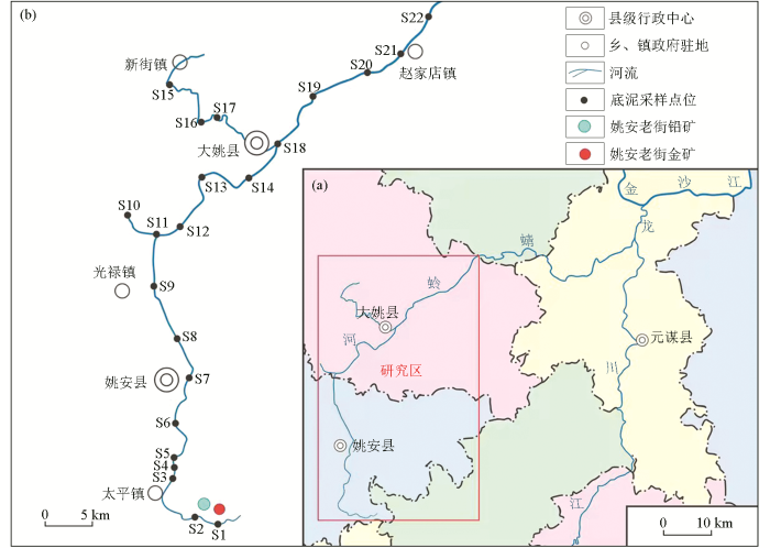
图1
研究区位置(a)和底泥样点分布(b)
Fig.1
Study area location (a) and distribution of the sediment samples (b)
1.2 分析方法
本次研究所采集的底泥样品由昆明自然资源综合调查中心分析测试实验室进行分析测试。底泥重金属监测指标为8项(As、Cd、Cr、Cu、Hg、Ni、Pb、Zn),其中As、Hg采用原子荧光光谱法(AFS)测定,检出限分别为0.63×10⁻⁶和0.000 3×10⁻⁶; Cr采用X射线荧光光谱法(XRF)测定,检出限为4×10⁻⁶;Cu、Cd、Pb采用电感耦合等离子体质谱法(ICP-MS)测定,检出限分别为0.46×10⁻⁶、0.03×10⁻⁶和1×10⁻⁶;Zn、Ni采用电感耦合等离子体发射光谱法(ICP-OES)测定,检出限分别为2×10⁻⁶和1×10⁻⁶。分析采用国家一级标准物质进行质量监控,每50件样品中密码插入4件国家一级标准物质,随机均匀插入各分析批次中与样品一起进行分析,计算单件监控样测定值与标准值之间的对数差,以控制分析的准确度;计算4件监控样测定值与标准值之间的平均对数差值,用以衡量批与批间的分析偏倚;计算4件监控样对数差的标准偏差,以衡量同批试样分析的精密度,并绘制日常监控图,确保样品测试质量。国家标准物质分析要求一次性原始合格率大于98%,准确度合格率要求大于98%,精密度合格率要求大于98%。分析过程中通过对检出限、精密度、准确度、重复性、异常点和报出率的检验及控制,确保了样品的质量控制与质量水平,并采用内检和外控相结合的方法,确保了样品数据的准确性和可靠性。
1.3 重金属污染评价方法
1.3.1 地累积指数法
Igeo=log2[Ci/(k×Bi)]。
表1 地累积指数评价指标
Table 1
| 等级 | Igeo值 | 污染程度 |
|---|---|---|
| Ⅰ | ≤0 | 无污染 |
| Ⅱ | 0~1 | 轻微污染 |
| Ⅲ | 1~2 | 中度污染 |
| Ⅳ | 2~3 | 中度—重度污染 |
| Ⅴ | 3~4 | 重度污染 |
| Ⅵ | 4~5 | 重度—极度污染 |
| Ⅶ | >5 | 极度污染 |
1.3.2 内梅罗综合污染指数法
Pi=Ci/Si,
P综=
表2 综合污染指数评价指标
Table 2
| 等级 | P综值 | 污染程度 |
|---|---|---|
| Ⅰ | ≤0.7 | 清洁 |
| Ⅱ | 0.7~1 | 尚清洁 |
| Ⅲ | 1~2 | 轻度污染 |
| Ⅳ | 2~3 | 中度污染 |
| Ⅴ | >3 | 重度污染 |
2 结果与分析
2.1 重金属含量特征
蜻蛉河22件底泥样品的重金属含量统计分析情况见表3,As、Cd、Cr、Cu、Hg、Ni、Pb、Zn含量平均值分别为10.81×10⁻⁶、0.38×10⁻⁶、101.19×10⁻⁶、33.51×10⁻⁶、0.04×10⁻⁶、44.61×10⁻⁶、115.24×10⁻⁶、119.20×10⁻⁶,超过云南省土壤背景值[33]的样品比例分别为31.82%、50.00%、86.36%、18.18%、18.18%、68.18%、27.27%和54.55%,超过全国土壤背景值[33-34]的样品比例分别为54.55%、77.27%、100.00%、77.27%、22.73%、90.91%、40.91%和72.73%。可以看出,底泥样品的8种重金属元素中As、Cu超标幅度较小,Cd、Cr、Ni、Zn的超标幅度较大。从变异系数看,8种重金属的变异系数大小为:Pb>Cd>Hg>Zn>As>Cu>Ni>Cr。
表3 底泥重金属元素含量分析统计
Table 3
| 项目 | As | Cd | Cr | Cu | Hg | Ni | Pb | Zn |
|---|---|---|---|---|---|---|---|---|
| 平均值/10-6 | 10.81 | 0.38 | 101.19 | 33.51 | 0.04 | 44.61 | 115.24 | 119.20 |
| 最小值/10-6 | 3.79 | 0.09 | 74.30 | 11.90 | 0.01 | 20.00 | 13.00 | 34.50 |
| 中位数/10-6 | 9.40 | 0.28 | 104.50 | 32.90 | 0.03 | 48.75 | 24.40 | 98.05 |
| 最大值/10-6 | 28.00 | 1.66 | 118.00 | 68.50 | 0.18 | 64.30 | 1003.00 | 493.00 |
| 标准偏差/10-6 | 6.29 | 0.36 | 11.16 | 13.83 | 0.04 | 12.28 | 246.67 | 99.20 |
| 变异系数 | 0.58 | 0.95 | 0.11 | 0.41 | 0.93 | 0.28 | 2.14 | 0.83 |
| 云南省土壤背景值/10-6 | 10.60 | 0.27 | 91.00 | 40.00 | 0.07 | 38.00 | 39.00 | 96.00 |
| 全国土壤背景值/10-6 | 9.10 | 0.15 | 63.00 | 23.00 | 0.05 | 26.00 | 25.00 | 67.00 |
2.2 重金属沿程分布特征
蜻蛉河底泥重金属含量的沿程分布特征如图2所示,从其沿程分布特征可以发现可能发生重金属污染的河段和分析重金属的可能来源。图中Pb、Zn、As、Cd、Cu表现出相似的分布特征,基本都在S1~S3段呈现出最大波峰,Pb、As的最高值出现在S2,Zn、Cd、Cu的最高值出现在S3,而S1~S3段在位置上与姚安县南部富碱斑岩区老街子Au-Pb-Ag多金属矿床相耦合,其富集可能与该区域矿业开采有关,而在S8、S18出现小幅度峰值,S8、S18为蜻蛉河分别经姚安县和大姚县流出的下游部位,这也表明其可能受到一定人类活动的影响。Hg与Pb、Zn、As、Cd、Cu表现出相似的分布特征,在S3、S8出现小幅度峰值,在S18出现最高值,表明其可能也受到了人类活动的影响。Cr、Ni与其他元素呈现了完全不同的分布特征,二者变化趋势相同,整体变化不大,分布较为均匀,表明二者受人类活动影响不大,可能主要来源为自然来源。
图2
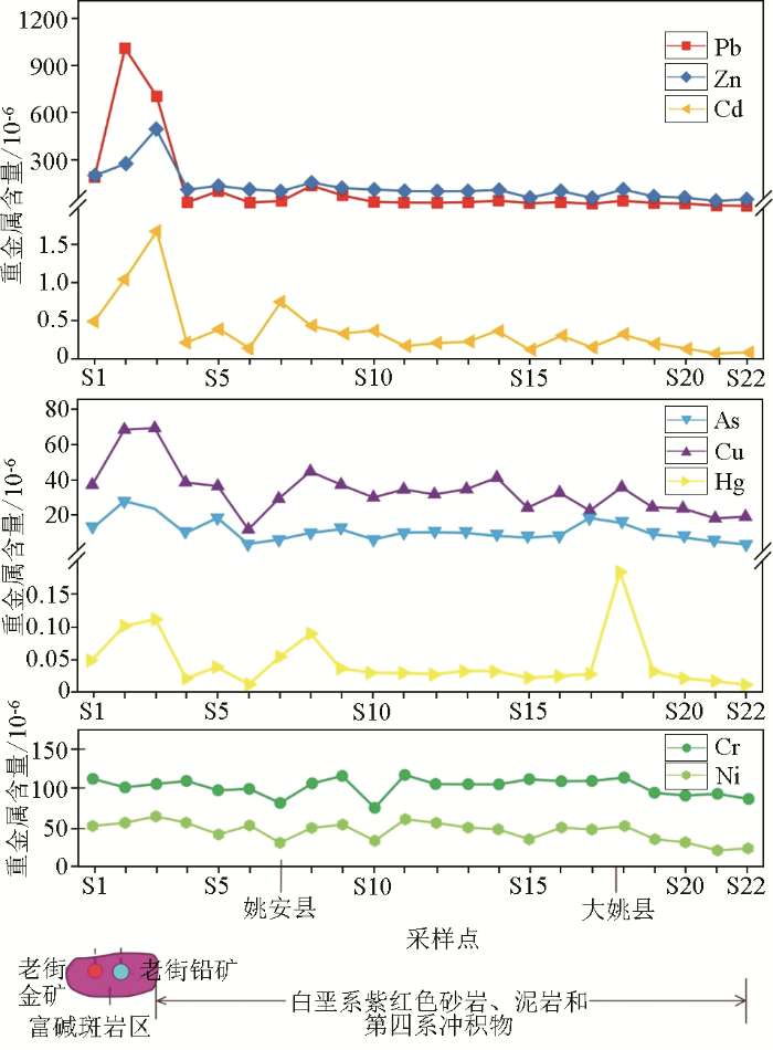
图2
蜻蛉河底泥重金属沿程分布
Fig.2
Distribution of heavy metals in the sediments of Qingling river
3 讨论
3.1 重金属来源解析
3.1.1 相关性分析
表4 底泥重金属相关性分析
Table 4
| 元素 | As | Cd | Cr | Cu | Hg | Ni | Pb | Zn |
|---|---|---|---|---|---|---|---|---|
| As | 1 | 0.710** | 0.310 | 0.808** | 0.621** | 0.562** | 0.817** | 0.727** |
| Cd | 1 | -0.045 | 0.839** | 0.572** | 0.406 | 0.825** | 0.940** | |
| Cr | 1 | 0.283 | 0.228 | 0.730** | 0.073 | 0.155 | ||
| Cu | 1 | 0.617** | 0.615** | 0.840** | 0.852** | |||
| Hg | 1 | 0.387 | 0.500* | 0.541** | ||||
| Ni | 1 | 0.406 | 0.574** | |||||
| Pb | 1 | 0.828** | ||||||
| Zn | 1 |
注:“*”表示P<0.05,“**”表示P<0.01。
3.1.2 主成分分析
表5 底泥重金属含量的主成分分析
Table 5
| 重金属元素 | 主成分 | 变量共同度 | |
|---|---|---|---|
| F1 | F2 | ||
| As | 0.890 | 0.019 | 0.792 |
| Cd | 0.885 | -0.371 | 0.921 |
| Cr | 0.329 | 0.911 | 0.938 |
| Cu | 0.945 | -0.033 | 0.894 |
| Hg | 0.702 | 0.009 | 0.493 |
| Ni | 0.682 | 0.634 | 0.868 |
| Pb | 0.881 | -0.273 | 0.851 |
| Zn | 0.922 | -0.168 | 0.878 |
| 初始特征值 | 5.161 | 1.475 | |
| 方差贡献率/% | 64.507 | 18.432 | |
| 累积方差贡献率/% | 64.507 | 82.939 | |
图3
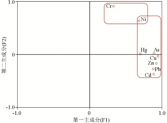
图3
底泥重金属主成分载荷
Fig.3
Principal component loading of heavy metals in the sediments
第一主成分(F1)贡献率(64.507%)远高于第二主成分,除Cr载荷较低外,其余重金属元素载荷均较高,As、Cd、Cu、Hg、Ni、Pb、Zn的载荷分别为0.890、0.885、0.945、0.702、0.682、0.881、0.922。7个元素除Ni的变异系数为中度变异外,As、Cd、Cu、Hg、Pb和Zn均为高度变异,As、Cd、Cu、Hg、Pb和Zn之间表现出显著的正相关关系,Ni与As、Cu、Zn表现出显著的正相关性,变化趋势相似,而从底泥的沿程分布特征情况来看,Pb、Zn、As、Cd、Cu和Hg表现出相似的分布特征,这些特征可能共同指向人类活动这一影响因素。有研究发现,矿山开采会显著增加周边土壤中的Cd、Hg、Pb、Cu、Zn、As、Ni[38],周艳等[39]的研究中发现,铅锌矿开采、选冶等生产活动所产生的废水、废渣等是周边土壤中As、Cd、Hg、Pb和Zn的主要来源。而这些积累在土壤中的重金属元素又会随着地表径流等方式进入河流和底泥中,所以其高值段在老街子Au-Pb-Ag多金属矿区出现可能与矿业开采有关。这些元素高值段另外还集中在河流从姚安县、大姚县流出的下游采样点位置。有研究表明,土壤和底泥中的Cd、Hg、Pb和Zn不仅会受到矿业活动的影响,还会受到农业活动的影响。如王美等[40]的研究发现长期施用磷肥易造成耕地中Cd、Pb的富集,长期施用有机肥易造成Cd、Cu、Zn和Pb的富集。Madrid等[41]的研究发现含Hg农药和化肥的使用会造成Hg的累积和污染。李旗等[42]的研究认为沉积物中Cd、Zn和Pb主要源于长期施用含有重金属的农药、化肥所造成的农业污染。研究区农业施肥主要以有机肥、复合肥和磷肥为主,少数区域存在农药过度使用的情况,所以这些高值段集中在县城下游位置可能与农业污染有关。还有研究表明,城郊农田土壤中As、Cd、Cu、Pb和Zn的来源与工业生产关系密切[43]。这些重金属高值区位于蜻蛉河在县城下游的城乡结合区,存在着工业企业,其生产活动排放的污染物也是造成这些重金属累积的重要因素。因此,综合分析判断可知,F1受矿产开采、农业活动和工业活动的共同影响。
第二主成分(F2)方差贡献率为18.432%,载荷较高的重金属元素为Cr和Ni,分别为0.911和0.634,其余元素除As、Hg为较小正载荷,其他元素均为负荷载。蜻蛉河底泥中Cr和Ni具有显著正相关关系,表明二者具有相似来源。从变异系数上来看,Cr、Ni变异程度较低,表明二者受人类活动影响较小,可能主要受地质背景影响。有研究发现,蜻蛉河所流经的姚安县土壤中的Cr、Ni主要受自然因素影响,受控于成土母质和地质背景[25]。宁增平等[44]的研究发现水系沉积物中的Cr、Ni主要源自岩石自然风化。秦元礼等[45]的研究也发现滇中地区武定县土壤中Cr、Ni主要来源于成土母质。因此可知F2主要代表了重金属元素的自然来源。
3.2 蜻蛉河底泥重金属污染程度评价
3.2.1 地累积指数法
蜻蛉河底泥中8种重金属的地累积指数统计结果如表6所示。8种元素Igeo平均值排序为:Ni(-0.42)>Cr(-0.44)>Cd(-0.50)>Pb(-0.56)>Zn(-0.57)>As(-0.76)>Cu(-0.95)>Hg(-1.68)。从Igeo平均值来看, 8种元素均为无污染(Igeo<0)。从点上看,有81.82%采样点的As、100%采样点的Cr、90.91%采样点的Cu、90.91%采样点的Hg、90.91%采样点的Ni、81.82%采样点的Zn为无污染;除Cr外的7个元素有9.09%~18.18%的采样点为轻微污染; 4.55%采样点的Cd、Zn和9.09%采样点的Pb为中度污染;Cd有4.55%的采样点为中度—重度污染;Pd均有4.55%的采样点为重度—极度污染和极度污染。从不同采样点的地累积指数变化情况来看,大部分存在污染的点主要集中在老街子多金属矿区及河流经过县城的位置,这表明蜻蛉河流域的底泥中Zn、Pd、Cd可能在人类生产生活的影响下积累明显,存在流域局部的点状富集状况。
表6 底泥重金属地累积指数等级分布情况
Table 6
| 元素 | Igeo | 比例/% | ||||||
|---|---|---|---|---|---|---|---|---|
| 变化范围 | 平均值 | Igeo<0 | 0<Igeo<1 | 1<Igeo<2 | 2<Igeo<3 | 3<Igeo<4 | 4<Igeo<5 | |
| As | -2.07~0.82 | -0.76 | 81.82 | 18.18 | 0 | 0 | 0 | 0 |
| Cd | -2.20~2.04 | -0.50 | 77.27 | 13.63 | 4.55 | 4.55 | 0 | 0 |
| Cr | -0.88~-0.21 | -0.44 | 100.00 | 0 | 0 | 0 | 0 | 0 |
| Cu | -2.33~0.19 | -0.95 | 90.91 | 9.09 | 0 | 0 | 0 | 0 |
| Hg | -3.39~0.78 | -1.68 | 90.91 | 9.09 | 0 | 0 | 0 | 0 |
| Ni | -1.51~0.17 | -0.42 | 90.91 | 9.09 | 0 | 0 | 0 | 0 |
| Pb | -2.17~4.10 | -0.56 | 72.72 | 9.09 | 9.09 | 0 | 4.55 | 4.55 |
| Zn | -2.06~1.78 | -0.57 | 81.82 | 13.63 | 4.55 | 0 | 0 | 0 |
3.2.2 内梅罗指数法
蜻蛉河底泥中8种重金属的单因子污染指数统计结果如表7所示。8种元素Pi平均值排序为:Pb(2.95)>Cd(1.41)>Zn(1.24)>Ni(1.17)> Cr(1.11)>As(1.02)>Cu(0.84)>Hg(0.63)。从各元素的Pi平均值来看,Pb为轻度污染(2<Pi≤3),As、Cd、Cr、Ni、Zn为潜在污染(1<Pi≤2),Cu、H为无污染(Pi≤1)。从点上看,81.82%采样点的Cr、68.18%采样点的Ni和40.91%采样点的Zn为潜在污染,远高于其他元素达到潜在污染的比例;As、Cd、Hg、Pd、Zn分别有9.09%、4.55%、4.55%、4.55%、9.09%的采样点为轻度污染;Cd、Pd、Zn分别有9.09%、18.18%、4.55%的采样点为重度污染。这表明底泥中Cd、Hg、Pd、Zn可能在人类生产生活的影响下明显积累,存在局部富集现象,而Cr、Ni虽然总体为潜在污染程度,但二者的Pi最高值均未超过2,Cr分别有18.18%、81.82%的采样点处于无污染和潜在污染区间,Ni分别有36.36%、63.64%的采样点处于无污染和潜在污染区间,这可能和流域在区域上Cr、Ni两种元素的背景值较高有关。
表7 底泥重金属单因子污染指数等级分布情况
Table 7
| 元素 | Pi | 比例/% | ||||
|---|---|---|---|---|---|---|
| 变化范围 | 平均值 | Pi≤1 | 1<Pi≤2 | 2<Pi≤3 | Pi>3 | |
| As | 0.36~2.64 | 1.02 | 68.18 | 22.73 | 9.09 | 0 |
| Cd | 0.33~6.15 | 1.41 | 50.00 | 36.36 | 4.55 | 9.09 |
| Cr | 0.82~1.30 | 1.11 | 18.18 | 81.82 | 0 | 0 |
| Cu | 0.30~1.71 | 0.84 | 81.82 | 18.18 | 0 | 0 |
| Hg | 0.14~2.57 | 0.63 | 81.82 | 13.63 | 4.55 | 0 |
| Ni | 0.53~1.69 | 1.17 | 31.82 | 68.18 | 0 | 0 |
| Pb | 0.33~25.72 | 2.95 | 72.72 | 4.55 | 4.55 | 18.18 |
| Zn | 0.36~5.14 | 1.24 | 45.45 | 40.91 | 9.09 | 4.55 |
通过表8可以看出,蜻蛉河底泥中8种重金属的内梅罗综合污染指数变化范围为0.74~18.54,平均值为2.75,总体处于中度污染程度。从点上看,流域没有一个采样点为清洁程度,只有22.73%的采样点为尚清洁,而达到轻度污染的比例为45.45%,分别有18.18%和13.64%的采样点为中度污染和重度污染。一半多的样点达到轻度污染程度及以上,这可能因为在区域上Cr、Ni两种元素的背景值较高,从而提高了重金属含量极值对结果权重的影响。而大部分存在中度和重度污染的点分布在流域南部老街子多金属矿区及其下游附近河道,这可能与矿区开采有关;而少部分存在中度污染的点分布在流域经过县城的位置,可能受到人类生活和工农业排污的影响。
表8 底泥重金属内梅罗综合污染指数等级分布情况
Table 8
| 内梅罗综合 污染指数 | P综 | 比例/% | |||||
|---|---|---|---|---|---|---|---|
| 变化范围 | 平均值 | P综≤0.7 | 0.7<P综≤1 | 1<P综≤2 | 2<P综≤3 | P综>3 | |
| 0.74~18.54 | 2.75 | 0 | 22.73 | 45.45 | 18.18 | 13.64 | |
4 结论
1)蜻蛉河底泥样品的重金属含量平均值超过云南省土壤背景值的样品比例分别为9.09%、54.55%、100%、9.09%、18.18%、63.64%、27.27%和68.18%,超过全国土壤背景值的样品比例分别为31.82%、90.91%、100.00%、86.36%、18.18%、90.91%、40.91%和72.73%。As、Cu超标幅度较小,Cd、Cr、Ni、Zn的超标幅度较大。8种重金属元素的变异系数大小为:Pb>Cd>Hg>Zn>As>Cu>Ni>Cr。Cr为轻度变异,Ni为中度变异,其余元素均为高度变异,总体上蜻蛉河流域底泥重金属的空间变异性以高度变异为主。蜻蛉河底泥重金属含量的沿程分布特征显示,Pb、Zn、As、Cd、Cu表现出相似的分布特征,其两个高值段分别集中在老街子Au-Pb-Ag多金属矿区和蜻蛉河经县城流出的下游区域;Cr、Ni也表现出相似的分布特征,二者变化趋势相同,整体变化不大,分布较为均匀。
2)应用相关性分析和主成分分析的方法探讨了蜻蛉河底泥重金属的来源,分别为矿产开采、农业活动和工业活动的复合污染源和自然来源。As、Cd、Cu、Hg、Ni、Pb、Zn主要受矿产开采、农业活动和工业活动的共同影响,Cr、Ni主要来源于成土母质,而Ni除了自然来源外,还受到了人为来源的影响。
3)运用地累积指数法、内梅罗指数法对蜻蛉河底泥的重金属污染程度的评价结果表明,8种重金属元素的平均污染程度不高,但存在部分元素在流域局部的污染富集,主要集中在老街子Au-Pb-Ag多金属矿区和县城下游的城乡结合区,代表元素为Cd、Hg、Pd和Zn。
参考文献
基于底泥重金属污染及生态风险评价的星云湖疏浚深度判定
[J].
Determination of dredging depth of Xingyun Lake based on heavy metal pollution and ecological risk assessment of sediment
[J].
太湖东部不同类型湖区疏浚后沉积物重金属污染及潜在生态风险评价
[J].
Pollution distribution and potential ecological risk assessment of heavy metals in sediments from the different eastern dredging regions of Lake Taihu
[J].
Risk assessment of trace element contamination in river sediments in Serbia using pollution indices and statistical methods:A pilot study
[J].
Accumulation and source of heavy metals in sediment of a reservoir near an industrial park of northwest China
[J].
DOI:10.1007/s11707-016-0560-9
[本文引用: 1]

The accumulation and source of heavy metals As, Ba, Co, Cr, Cu, Mn, Ni, Pb, V, and Zn in the surface sediment of a reservoir near an industrial park of northwest China were determined by enrichment factor and multivariate statistical analysis. Multivariate statistical analyses, i.e., factor analysis, cluster analysis, and correlation coefficient analysis, were used to identify the possible sources of the heavy metals. The results show that the mean concentrations of As, Ba, Co, Cr, Cu, Mn, Ni, Pb, V, and Zn in the reservoir sediment are higher than their corresponding concentrations in the control sample, indicating all analyzed heavy metals accumulated in the surface sediments. The values of the mean concentrations of heavy metals in the surface sediment divided by their corresponding concentrations in the control sample increase in the order of Ba= Cr<Co= Pb<V<Ni<Cu= Zn<As<Mn. The enrichment factor values of Ba and Cr in the surface sediment samples are<2, revealing minimal enrichment, while the enrichment factor values of As, Co, Cu, Mn, Ni, Pb, V, and Zn are in the range of 2?5, displaying moderate enrichment. Combining the results of correlation coefficient analysis, factor analysis, and cluster analysis, three main sources of these heavy metals were identified. As, Co, Cu, Mn, Ni, and V have mixed sources of natural and industrial sources and local consumption residues; Pb and Zn mainly originate from industrial activities, while Ba and Cr primarily originate from natural sources.
兰州市城区河道表层沉积物重金属污染及磁学参数相关关系研究
[J].
Characteristics of heavy metal elements and their relationship with magnetic properties of river sediment from urban area in Lanzhou
[J].
Ecological risk assessment and sources identification of heavy metals in surface sediments of a river-reservoir system
[J].
Geochemistry of sediments in three sectors of Trincomalee Bay,Sri Lanka:Provenance,modifying factors and present environmental status
[J].
三峡库区重金属的生物富集、生物放大及其生物因子的影响
[J].
Bioaccumulation and biomagnification of heavy metals in Three Gorges Reservoir and effect of biological factors
[J].
包头市三类湿地中重金属污染程度及生物富集研究
[J].
Study on pollution degree and bio-concentration of heavy metals in three types of wetlands in Baotou,China
[J].
Environmental and ecological risk of heavy metals in the marine sediment from Dakhla Bay,Morocco
[J].
Assessment of heavy metal pollution,distribution and source apportionment in the sediment from Feni River estuary,Bangladesh
[J].
开封城郊河道底泥重金属形态垂向分布特征及风险评价
[J].
Vertical distribution characteristics and risk assessment of heavy metals in core sediments from Kaifeng suburban rivers
[J].
基于蒙特卡洛模拟与PMF模型的黄河流域沉积物重金属污染评价及源解析
[J].
Evaluation and source analysis of heavy metal pollution in sediments of the Yellow River Basin based on Monte Carlo simulation and PMF model
[J].
Distribution of heavy metals and environmental assessment of surface sediment of typical estuaries in eastern China
[J].
DOI:S0025-326X(17)30493-9
PMID:28606613
[本文引用: 1]
Estuary sediment is a major pollutant enrichment medium and is an important biological habitat. This sediment has attracted the attention of the marine environmental scientists because it is a more stable and effective medium than water for monitoring regional environmental quality conditions and trends. Based on a large amount of measurement data, we analyzed the concentrations, distribution, and sources of seven heavy metals (As, Cd, Cr, Cu, Hg, Pb, and Zn) in the surface sediment of typical estuaries that empty into the sea in eastern China: the Liaohe River Estuary, Yellow River Estuary, Yangtze River Estuary, Minjiang River Estuary, and Pearl River Estuary. The heavy metal concentrations in the sediments vary considerably from one estuary to the next. The Liaohe River Estuary sediment contains elevated levels of Cd, Hg, and Zn. The Yellow River Estuary sediment contains elevated levels of As. The sediments in the Yangtze River and Minjiang River estuaries contain elevated levels of Cd and Cu and of Pb and Zn, respectively. The sediment in the Pearl River Estuary contains elevated levels of all seven heavy metals. We used the Nemerow index method to assess the environment quality. The heavy metal pollution in the Liaohe River and Pearl River estuaries is more severe than that in the other estuaries. Additional work indicates that the heavy metal pollution in the Liaohe River and Pearl River estuaries is caused mainly by human activity.Copyright © 2017. Published by Elsevier Ltd.
湖南省主要水系底泥重金属污染特征及其生态风险评价
[J].
Pollution characteristics and ecological risk assessment of heavy metals in sediments of main water systems in Hunan Province
[J].
某区饮用水源地重金属分布特征、污染评价及源解析
[J].
Distribution characteristics,pollution assessment and source analysis of heavy metals in a drinking water source area
[J].
苏州水网地区河道底泥的重金属分布特征与污染风险
[J].
Distribution characteristics and pollution risk of heavy metals in river sediment of Suzhou water network area,China
[J].
The extent and historical trend of metal pollution recorded in core sediments from the artificial Lake Shihwa,Korea
[J].
苏州古城区域河道底泥的重金属污染分布及生态风险评价
[J].
Pollution distribution and ecological risk assessment of heavy metals in river sediments from the ancient town of Suzhou
[J].
“十三五” 期间滇池外海底泥重金属污染特征分析及生态风险评价
[J].
Pollution characteristics and ecological risk assessment of heavy metals in sediments of Dianchi outer lake during the ‘13th Five-Year Plan period’
[J].
河流底泥重金属污染研究进展
[J].
Research progress and prospects of heavy metal pollution in river sediment
[J].
长江中下游底泥重金属污染特征、潜在生态风险评价及来源分析
[J].
Pollution characteristics,potential ecological risk assessment and source analysis of heavy metals of sediment in the middle and lower reaches of the Yangtze River
[J].
变化环境下滇中地区典型流域水资源演变特征
[J].
Evolutions of water resources in typical basin of central Yunnan Province under changing environment
[J].
滇中姚安老街子板内富碱火山岩锆石SHRIMP U-Pb年代学及火山机构划分
[J].
Zircon SHRIMP U-Pb geochronology and volcanic edifice division of the laojiezi intraplate alkali-rich volcanic rocks in Yao'an,central Yunnan province
[J].
滇中姚安地区土壤重(类)金属来源分析及生态风险评价
[J].
Sources analysis and ecological risk assessment of soil heavy metals and metalloids in Yao'an area of central Yunnan
[J].
云南姚安Au-Pb-Ag矿床含矿富碱岩浆岩地球化学特征及岩石成因
[J].
The geochemical characteristics and petrogenesis of the mineralized alkali-rich magmatic rock in Yao'an Au-Pb-Ag deposit,Yunnan Province
[J].
Ecological risk assessment of the metallic pollution in the soil and sediment in Tingjiang Basin
[J].
Index of geoaccumulation in sediments of the Rhine River
[J].
Traffic-related trace elements in soils along six highway segments on the Tibetan Plateau:Influence factors and spatial variation
[J].
皖江经济带土壤Cd空间分布特征与生态风险评价
[J].
DOI:10.31497/zrzyxb.20211218
[本文引用: 1]
选取2.5 km×2.5 km网格布点法,在皖江经济带A、B、C三地分别采集土壤样品35个、34个、106个,利用ICP-AES分析测定Cd含量特征,运用单项污染指数法、地累积指数法和潜在生态风险指数法对三地土壤Cd污染状况进行生态风险评价。结果表明:(1)A、B、C三地土壤的Cd含量的算术平均值分别为0.40 mg?kg <sup>-1</sup>、0.66 mg?kg <sup>-1</sup>、0.84 mg?kg <sup>-1</sup>,均高于江淮流域Cd含量土壤背景值;(2)三地土壤pH在5.06~7.58之间,整体上处于酸性和弱碱性之间,pH小于7.0的样品167个,占比95.43%;(3)研究区三个地块土壤Cd污染特征存在明显的空间分异,低污染区在空间上呈带状分布,高污染区在空间上呈岛状分布,污染区分布面积C地>B地>A地。(4)三地土壤环境均受重金属Cd污染的影响,存在生态安全风险,风险大小为C地>B地>A地,风险程度均为潜在生态风险高于地累积生态风险高于单项污染生态风险。本区域土壤农业安全利用需要加以重视并进行分类管控。
Spatial distribution characteristic of Cd in soils and its ecological risk assessment in the economic belt of Yangtze River in Anhui
[J].
滁州市表层土壤重金属含量特征、源解析及污染评价
[J].
Heavy metal concentration,source,and pollution assessment in topsoil of Chuzhou City
[J].
南方丘陵区土壤重金属含量、来源及潜在生态风险评价
[J].
Evaluation of heavy metal content,sources,and potential ecological risks in soils of southern hilly areas
[J].
基于大数据的中国土壤背景值与基准值及其变化特征研究——写在《中国土壤地球化学参数》出版之际
[J].
Big data based studies of the variation features of Chinese soil’s background value versus reference value:A paper written on the occasion of soil geochemical parameters of China’s publication
[J].
Spatial variability:Its documentation,accommodation and implication to soil surveys
[G]//
太湖流域河流沉积物重金属分布及污染评估
[J].
Spatial distribution and pollution assessment of heavy metals in river sediments from Lake Taihu Basin
[J].
Spatial distribution,source identification and pollution assessment of metal content in the surface sediments of Nansi Lake,China
[J].
基于Meta分析的矿区周边土壤重金属污染特征及风险评价
[J].
DOI:10.13745/j.esf.sf.2023.9.9
[本文引用: 1]
本文基于2002—2022年期间,知网、万方、Web of Science数据库收录的矿区周边土壤重金属文献数据,采用Meta分析方法,探讨我国不同地区和矿种类别的矿山开采对土壤重金属分布特征的影响。同时,结合地累积指数法和潜在生态风险指数法评估矿区周边土壤重金属生态风险。Meta分析结果显示,我国矿区周边土壤中镉(Cd)、汞(Hg)、铜(Cu)、铅(Pd)、锌(Zn)、砷(As)、镍(Ni)和铬(Cr)的浓度相较于土壤背景值,分别增加了820.7%、309.6%、158.6%、158.6%、146.0%、103.4%、24.6%和15%,其中,Cd和Hg增加量较多。从地区来看,中南和西南地区的矿区周边土壤重金属的效应值较大,其重金属浓度增加量分别为285.7%和180.1%,其中西南、中南和华东地区矿山周边土壤中Cd、Hg、Zn、Pb和Cu的含量增加较为显著,华北和东北地区的Cd和As、西北地区的Cd和Hg增加较为显著。从矿种类型看,铅锌矿、多金属矿、铜矿、金矿、汞矿、钼矿、锰矿、锡矿和包含石墨矿等其他矿种的周边土壤重金属浓度增加量为166.4%~617.1%,其中铅锌矿开采会使得Cd、Hg、Pb和Zn显著累积,金矿开采对As、Hg和Pb累积显著,铜矿、石墨、硫铁矿等其他矿种对Cd和Cu的含量累积显著,各类型矿对Ni和Cr的累积影响都很小。地累积指数法和潜在生态风险指数法评价结果显示,我国矿区周边土壤Cd和Hg地累积污染指数分别达到中等和轻微污染等级,且大部分土壤位点二者都具有高等级的潜在生态风险,因此,需加强矿区周边重点重金属Cd和Hg的污染防治。
A Meta-analysis of the distribution characteristics and ecological risk of heavy metals in mining areas
[J].
DOI:10.13745/j.esf.sf.2023.9.9
[本文引用: 1]
In this study, we perform a meta-analysis to investigate the distribution characteristics of heavy metals in soils in mining areas, in different regions and of different mining types in China, using 2002-2022 relevant soil data from CNKI, Wanfang, and Web of Science databases. In addition, geo-accumulation index and potential ecological risk index were used to assess the ecological risk of heavy metals in soils around mining areas. The Meta-analysis findings revealed that the concentrations of Cd, Hg, Cu, Pb, Zn, As, Ni, and Cr in soils around mining areas in China increased by 820.7%, 309.6%, 158.6%, 158.6%, 146.0%, 103.4%, 24.6%, and 15%, respectively, compared to the corresponding background values, among which Cd and Hg showed the greatest increases. Region wise, the central south and southwest of China were greatly impacted by mining and showed increases of 285.7% and 180.1%, respectively. Nationwide, Cd, Hg, Zn, Pb, and Cu increased the most in the southwest, central south, and east; Cd and As in the north and northeast; and Cd and Hg in the northwest. In terms of mined mineral/material types, heavy metal contamination increased greatly around metal mines such as lead-zinc, polymetallic nudule, copper, gold, mercury, molybdenum, manganese, and tin mines, and non-metal mines such as graphite mines, with increases of 166.4% to 617.1%. Lead-zinc mining led to significant accumulation of Cd, Hg, Pb, and Zn, and gold mining resulted in significant accumulation of As, Hg, and Pb. Copper mining and others such as graphite and pyrite mining all showed significant accumulation of Cd and Cu, except Ni and Cr which showed relatively small accumulation regardless mined mineral/material types. Evaluation results using geo-accumulative index and potential ecological risk index showed that the overall levels of Cd and Hg contamination in soils around mining areas were moderate and slight geo-accumulation, respectively, and a high potential ecological risk level was observed in most soil sites. Therefore, it is necessary to pay more attention to Cd and Hg pollution control and prevention in mining areas.
西南某铅锌矿区农田土壤重金属空间主成分分析及生态风险评价
[J].
Principal component analysis and ecological risk assessment of heavy metals in farmland soils around a Pb-Zn Mine in south-western China
[J].
肥料重金属含量状况及施肥对土壤和作物重金属富集的影响
[J].
Heavy metals in fertilizers and effect of the fertilization on heavy metal accumulation in soils and crops
[J].
Distribution of heavy metal contents of urban soils in parks of Seville
[J].
DOI:10.1016/s0045-6535(02)00530-1
PMID:12489727
[本文引用: 1]
Several metals in urban soils of Seville were extracted by two methods, which respectively give estimates of the available and 'quasi total' contents. Although the soils did not show strong heterogeneity in their general properties, high dispersion of the contents in those metals with greater relative availability, Cu, Pb and Zn, as compared to others suggested that pollution with these three metals could occur in some sampling sites. It was shown that the contents in these metals tend to increase as the historic quarters of the city are approached. Using reference values given by the Quebec Ministry of Environment it was shown that those green areas closer to the historic centre present contents in Pb, Zn and particularly Cu that often exceed the acceptable limits for residential, recreational and institutional sites. From background contents for Seville soils estimated from a park located on the outskirts, a pollution load index (PLI) for each sampling site was calculated for the set of these three metals. It was shown that the PLI tends to increase as traffic density increases and as distance from main traffic decreases, but poor regressions were obtained, suggesting that other variables different from traffic should be considered.
漓江上游青狮潭灌区干支渠沉积物重金属分布规律及来源解析
[J].为了揭示漓江上游农业区域灌渠重金属含量及其分布规律,通过选取青狮潭水库西干渠及其支渠为研究对象,测定了干支渠表层沉积物(0~5 cm)的重金属含量,分析沉积物重金属的分布特征和污染现状,进行潜在生态风险评价,利用pearson相关性分析与正定矩阵因子分解法(PMF)分析重金属来源。结果表明,沉积物重金属含量在水稻生长的灌溉季节(平水期)和非灌溉季节(枯水期)平均值大小顺序均为Zn>Cr>Pb>Cu>As>Cd>Hg,干渠和支渠之间,灌溉季节和非灌溉季节之间沉积物重金属含量差异显著。灌渠沉积物的重金属潜在生态风险等级为强,Cd与Hg是主要污染物,不同季节和干支渠直接的重金属潜在生态风险等级差异。干支渠沉积物重金属来源包括工业污染源、农业污染源与城市(城镇)污染源,其中,农业污染源占主导,贡献率为42.45%,工业污染源与城市(城镇)污染源贡献率分别为33.86%与23.69%。
Distribution and source analysis of heavy metals in sediments of qingshitan irrigation district in Lijiang River Basin
[J].In order to reveal the content and distribution of heavy metals in agricultural areas of the Lijiang River Basin, the west main canal and its tributaries of Qingshitan Irrigation District are selected as the research objects in this paper. The content of heavy metals in the surface sediments (0~5 cm) of the main and its tributaries is determined, and the distribution characteristics and pollution status of heavy metals in sediments are analyzed. The potential ecological risk assessment is carried out. The pearson correlation analysis and positive definite matrix factor decomposition (PMF) are used to analyze the sources of heavy metals. The results show that the average contents of heavy metals in sediments in irrigation season and non-irrigation season are Zn>Cr>Pb>Cu>As>Cd>Hg, and the contents of heavy metals in sediments in main canals and tributaries, irrigation season and non-irrigation season are significantly different. The potential ecological risk of heavy metals in the sediments of irrigation canals is strong, Cd and Hg are the main pollutants, and the potential ecological risk levels of heavy metals in different seasons and direct tributaries are different. The sources of heavy metals in sediments of main and branch channels include industrial pollution sources, agricultural pollution sources and urban pollution sources. Among them, agricultural pollution sources accounts for 42.45%, industrial pollution sources and urban pollution sources accounts for 33.86% and 23.69%, respectively.
基于正定矩阵因子分析模型的城郊农田重金属污染源解析
[J].
Analysis of heavy metal pollution sources in suburban farmland based on positive definite matrix factor model
[J].
都柳江水系沉积物锑等重金属空间分布特征及生态风险
[J].
Spatial distribution characteristics and potential ecological risk of antimony and selected heavy metals in sediments of Duliujiang river
[J].
