

0 引言
传统的重磁数据处理和解释技术,如边界识别、快速成像、欧拉反褶积以及界面反演等方法,主要是对异常体的几何位置进行定位,与之相比,重磁位场数据三维物性反演是通过将观测区域的地下空间离散成规则的网格单元,并通过反演计算物性的分布,可以有效地提供地下异常体的几何位置、形状和物性参数等定量信息[5]。当前三维物性反演技术日渐成熟和完善,被广泛应用于固体矿产详查。李玉录等[6]在跃进山铁矿区,利用磁法3D反演结果截面切片图推断的磁性体与地质工程实际控制的磁铁矿体位置基本吻合,产状基本相近,说明三维反演的方法可行有效;张明君等[7]在伊吾县宝山铁矿区利用三维反演技术,结合磁测井和地质资料,确定了隐伏矿的位置,说明重磁三维反演在类似矿区找矿增储中有着良好的应用前景;刘璎等[8]在新疆白石泉铜镍矿区的实践应用证实,利用重磁三维物性反演技术,可以较好地获取地下空间磁性差异的地质体的空间分布形态,为进一步分析研究隐伏矿定位提供重要信息,取得了很好的实践找矿效果。此外,还有更多的学者在其研究的工区利用三维反演技术,均取得了较为理想的结果 [9⇓⇓⇓⇓⇓⇓-16]。为了改善大比例尺面积性磁场数据的三维反演效率,张恒磊等[17]提出了曲波压缩反演方法,该方法采用与传统小波压缩反演[18]相同的反演策略,因此该方法与传统方法的计算量相似;不同的是,在相同计算精度条件下,前人指出曲波压缩相比小波压缩可以将核函数压缩率提高100%,降低50%的内存需求[17],使得普通计算机硬件条件能够满足较大规模重磁异常三维反演的计算需求。
1 地质地球物理概况
尕林格铁矿床与奥陶纪滩间山群有关,矿床类型为矽卡岩型铁多金属矿。从成矿规律看:本区铁矿成矿时间在早古生代,成矿物质来源于上地幔;滩间山群火山喷流(气)沉积成矿系统发育,喷流沉积改造型矿床占主导地位;本区华力西、印支—燕山期的中—酸性侵入岩在成矿作用上提供了物源和热能,并对前期形成的矿床进行叠加改造;成矿作用所特有的规律是:铁矿在前,铜矿次之,铅锌最后。
图1
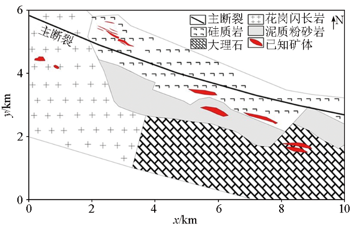
表1 研究区岩矿石标本磁性参数
Table 1
| 岩矿名称 | 标本数 | 几何平均值 | |
|---|---|---|---|
| κ/(4π·10-6SI) | Jr/(10-3A·m-1) | ||
| 致密块状磁铁矿 | 149 | 5.01×10⁵ | 6.40×10⁴ |
| 稀疏浸染状磁铁矿 | 171 | 4.23×10⁴ | 2.86×10⁴ |
| 磁铁矿化黄铁矿 | 19 | 5.90×10⁴ | 2.56×10⁴ |
| 含磁铁矿磁黄铁矿 | 27 | 1.02×10⁴ | 2.34×10³ |
| 磁铁矿化矽卡岩 | 56 | 1.23×10⁴ | 6.41×10³ |
| 磁铁矿化硅质角岩 | 9 | 9.2×10⁴ | 7.36×10³ |
| 磁铁矿化辉石岩 | 25 | 8.27×10⁴ | 9.97×10³ |
| 矿化大理岩 | 12 | 1.33×10³ | 4.88×10² |
| 矽卡岩化大理岩 | 47 | 1.49×10³ | 4.91×10² |
| 细晶闪长岩 | 3 | 1.07×10³ | 8.15×10² |
| 泥质硅质岩 | 16 | 3.77×10² | 1.98×10² |
2 磁异常三维反演
图2是9线的钻孔剖面,其中有两口千米级钻孔,揭示该区在深部1 000 m深度依然存在磁铁矿体。图3是矿区磁异常彩色影像,网格间距20 m,总网格点数88×70,从图上可以看出ΔT异常形态较为规则,呈似纺锤状,异常北陡南缓。研究区地磁场倾角、偏角分别为56.5°、0.2°,图3显示正、负磁异常伴生且正异常幅值及范围较负异常区更大,反映了较为典型的中高纬度磁异常的特征。表1中显示了矿体及矿化体具有显著的强剩磁,为此,使用了相关性方法进行总磁化倾角与偏角的估算。通过试验不同的总磁化倾角与偏角,采用化极异常与归一化磁源强度的垂向导数的相关系数的最高值来估计总磁化倾角与偏角[25],计算得到的相关系数如图4所示,估计得到的总磁化倾角58°,总磁化偏角-26°。
图2
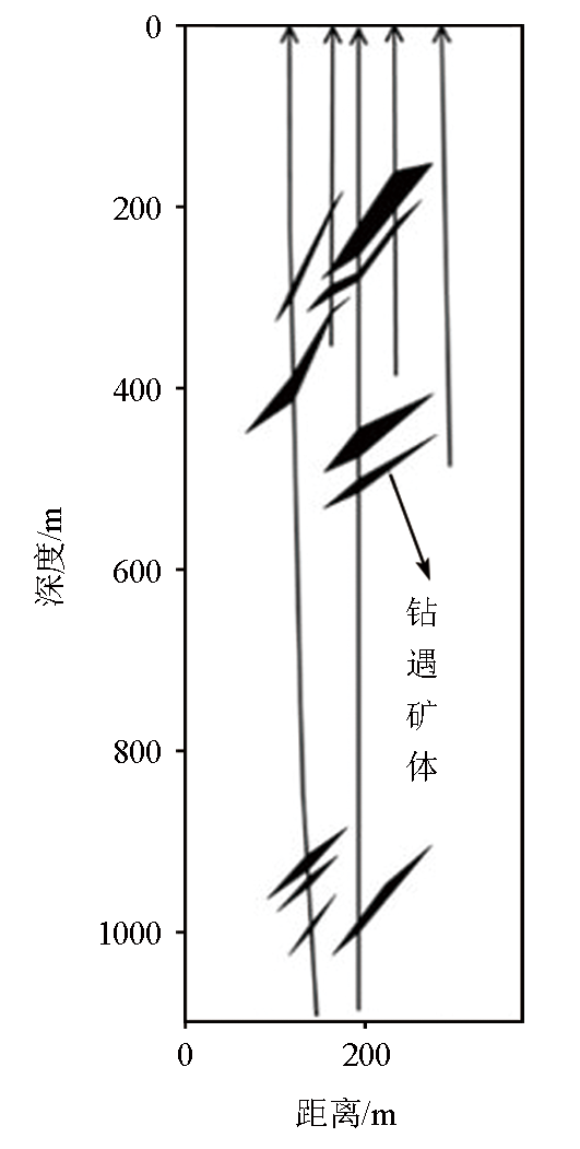
图3
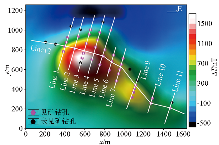
图4
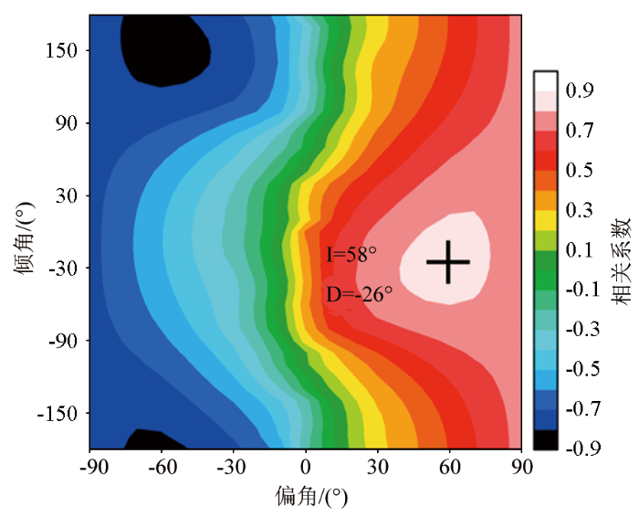
图4
化极异常与归一化磁源强度的垂向导数的相关系数
Fig.4
The correlation coefficient diagram between the RTP anomaly and the vertical derivative of the normalized magnetic source intensity
由于矿体埋藏较深,产生的磁异常宽缓,难以直接根据强磁异常推测矿体分布,因此,朱朝吉等[19]、张恒磊等[26]利用了小波多尺度分析,分析矿体水平位置;宋双等[27]利用向下延拓,将原本一个异常中心的叠加异常场区分成六个局部异常,提升了磁异常的分辨力;张恒磊等[28]利用边界识别方法在非垂直磁化条件下对矿区磁异常直接进行边界探测,推测了矿体的水平边界位置。本文从磁异常三维反演的角度,采用中国地质大学(武汉)开发的Mag3Dimaging磁异常反演软件,通过反演研究区地下三维磁化强度,为后续隐伏矿体追踪、钻探设计等提供依据。先将地下空间按照20 m间距划分,得到三维剖分单元数为88×70×50,采用曲波压缩进行三维反演[17],相较于传统小波压缩三维物性反演,曲波压缩在较低的压缩比下反演结果具有更高的精度,采用曲波压缩能够更好地保持核矩阵压缩精度。利用的约束条件是覆盖层内(0~150 m)磁化强度为零,使用32 GB 内存、2.90 GHz主频的移动工作站进行计算,核矩阵计算耗时约1 h,经过40次迭代(图5)耗时19 min,得到的拟合磁异常及剩余异常如图6所示。
图5
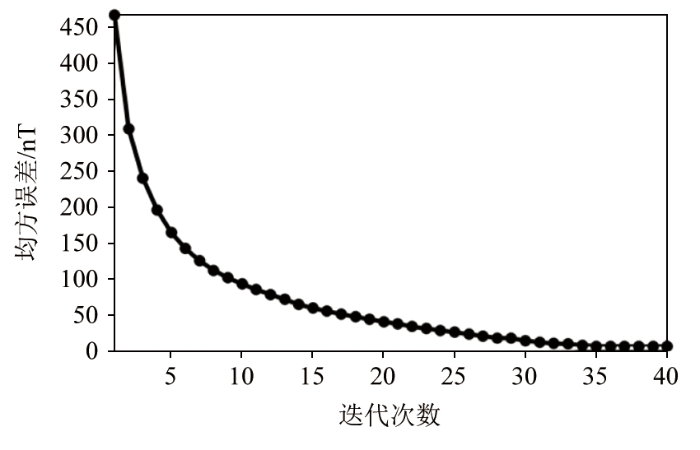
图6
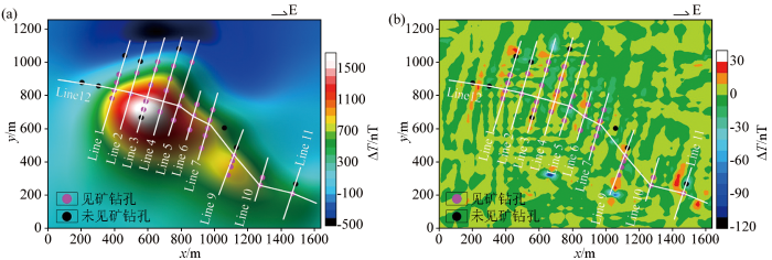
图6
三维反演拟合磁异常(a)与剩余磁异常(b)
Fig.6
Three-dimensional inversion fitting of magnetic anomalies (a) and residual magnetic anomalies (b)
图7
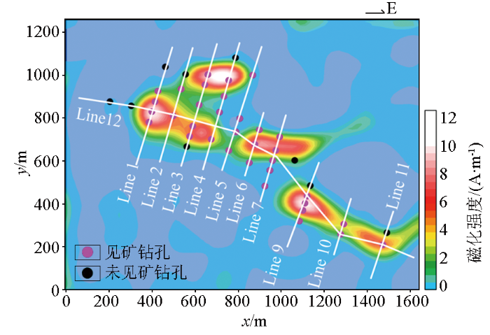
图7
三维磁化强度200 m深度水平切片
Fig.7
Three-dimensional magnetization intensity horizontal slice at 200 meters depth
图8
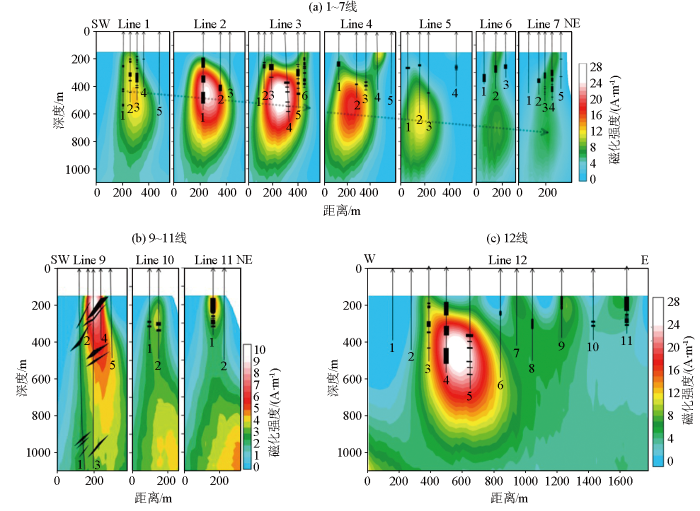
图8
三维磁化强度深度切片
(图中箭头线表示钻孔及钻孔编号,黑色块体表示钻遇的矿体)
Fig.8
Three-dimensional magnetization intensity depth slice
(The arrow lines represent the drillhole locations, and the black blocks represent the ore ranges illustrated by the drilling)
反演得到的磁化强度总体反映了矿体南倾的特征,磁化强度的中心深度由1线的400 m向东逐渐加深到6线的700 m左右(图8a中虚线箭头走向)。2线和3线的两口600 m深度左右的钻孔揭示了该强磁化异常体强度中心对应的厚层/多层矿体,表明反演结果的客观性。而9线两口千米深度的钻孔也揭示了矿体的分布与反演得到的磁化强度具有较好的对应性,说明反演得到的磁化强度能较好地反映矿体的空间分布特征。
3 分析与总结
三维反演在磁法数据处理与解释过程中具有重要作用,它能够提供更加丰富的异常体的空间展布信息以及磁性特征,能够为磁铁矿详查提供可靠的依据。尕林格矿区地表覆盖层厚度大、磁性体相对围岩具有显著的磁性差异,因此磁法勘探是本区最有效的地球物理勘查手段。本文利用地面1∶5 000磁异常,构建了地下1 200 m深度内的三维磁化强度模型,总体上反映了该区矿体的总体展布特征,能够为后续旁侧隐伏矿体与深部隐伏矿体勘查提供依据,也可以为该区资源量评估提供参考。
在磁异常反演实践应用中,有几个问题值得引起重视:
1)剩磁的影响。强磁化率岩矿石通常亦具有显著的剩磁特征,如本区岩矿石标本测量结果表明矿体及矿化体的剩磁强度与感磁强度相当,可能引起总磁化方向与地磁场方向显著不同,对后续磁异常处理解释造成困扰。因此,需要在磁异常处理解释前,采用适当的方法估计总磁化方向。
2)重磁勘探具有显著的体积效应,尤其对相距较近的垂向叠加异常体的分辨能力不足,可能导致反演的磁化强度在深度方向上产生等效性,反演的强化强度中心往往位于多层叠加矿体的中上部。
3)选取合适的模型剖分尺度进行三维反演。三维反演模型剖分尺度大多默认采用一倍测点距大小进行反演,在硬件允许情况下可以考虑采用较小剖分尺度进行三维反演,有利于得到更加精细的三维磁化强度模型。
参考文献
青海省尕林格富铁矿床地质特征及成因探讨
[J].青海省尕林格铁矿床位于东昆仑西段祁漫塔格弧后盆地中部。近年来通过新一轮地质勘查工作,该矿床铁资源/储量进一步的扩大。通过分析研究认为,朵林格矿床的铁矿体呈似层状、透镜状基本顺层产于一套奥陶纪滩间山群(OST)的火山-沉积岩中,矿体规模大,厚度基本稳定,其成矿地质背景和矿床地质特征表明,该矿床属火山喷流沉积一岩浆热液叠加改造型铁矿床。
The study on the genesis and geological characteristics of Galinge high-grade iron deposit of Qinghai Province
[J].
青海祁漫塔格地区斑岩铜矿的成矿条件和远景
[J].
Metallogenic environment and potential in the Qimantage porphyry copper deposit,Qinghai
[J].
地面磁测资料反演与井中磁测联合找矿——以尕林格铁多金属矿床Ⅱ矿段为例
[J].
Joint prospecting of ground magnetic survey data inversion and borehole magnetic survey:A case study of Galinge Fe-polymetallic deposit
[J].
基于BTTB矩阵的快速高精度三维磁场正演
[J].
Fast and high accuracy 3D magnetic anomaly forward modeling based on BTTB matrix
[J].
起伏观测面约束的重磁数据快速联合物性反演方法研究
[J].
DOI:10.6038/pg2024HH0390
[本文引用: 1]

重磁联合反演能够综合重磁数据特征直接获取地下密度及磁性分布,有效揭示不同岩性分布及地下构造,是矿产资源勘查的重要手段.实际地表以及沿地形起伏的航空重磁测量的观测面都是起伏的,为实现起伏观测面的重磁高效率联合物性反演,我们建立了一种起伏观测面约束下的重磁数据快速联合物性反演方法,其首先是依据最大观测高度对数据进行曲化平处理,然后利用Block-Toeplitz-Toeplitz-Block(BTTB)-FFT实现快速反演,并将换算观测面与实际观测面的空间作为约束来消除无效网格单元计算所带来的多解性,从而本方法能够实现高效率反演且不因额外的剖分单元而增加求解多解性.模型试验表明本方法在能够有效地提高多于32倍的计算效率且不损失反演计算的精度,且对于含噪数据反演也具有良好的稳定性.最后,我们将本方法应用到中国吉林省东部通化盆地三棵榆树凹陷,获得了该地区基底和火成岩分布,该地区的盆地基底平均深度约为2.5 km,同时火成岩发育主要集中在基底深度较大的区域,为下一步油气勘探提供重要基础地质信息,亦对松辽盆地东部外围新区的油气勘探部署提供重要的指导意义.
A study of fast joint physical inversion methods of gravity and magnetic data with undulating observation surface constraints
[J].
DOI:10.6038/pg2024HH0390
[本文引用: 1]
Joint inversion of gravity and magnetic can directly obtain the underground density and magnetic distribution by synthesizing the characteristics of gravity and magnetic data,and effectively reveal different lithology distribution and underground structure,which is an important means of mineral resources exploration. The actual surface of the earth and the observed surface of the airborne gravity and magnetic survey that fluctuates along the terrain are both undulating. In order to realize the highly efficient joint inversion of the undulating observation surfaces,we have established a fast joint physical inversion method for gravity and magnetic data under the constraints of undulating observation surfaces. Firstly,the data is flattened according to the maximum observed height. Then,Block-Toeplitz-Toeplitz-Block(BTTB)-FFT is used to achieve fast inversion,and the space between the converted observation plane and the actual observation plane is used as a constraint to eliminate the multiple solutions caused by the calculation of invalid grid cells. Therefore,this method can achieve high efficiency inversion without increasing the multiplicity of solutions due to additional partition elements. Model tests show that this method can effectively improve the computational efficiency by more than 32 times without losing the accuracy of inversion calculation,and has good stability for noisy data inversion. Finally,we applied this method to Sankeshu Depression,Tonghua Basin,eastern Jilin Province,China,and obtained the distribution of basement and igneous rocks in this area. The average depth of basin basement in this area is about 2.5 km,and the development of igneous rocks is mainly concentrated in the area with large basement depth,which provides important basic geological information for the next oil and gas exploration.It also provides important guiding significance for oil and gas exploration and deployment in the eastern peripheral new area of Songliao Basin.
综合物探方法在青海省跃进山铁矿勘查中的应用
[J].
The application of comprehensive geophysical prospecting method to the exploration of the Yuejinshan iron deposit in Qinghai
[J].
重磁3D反演在新疆伊吾县宝山铁矿找矿增储中的应用
[J].
Application of gravity and magnetic 3D inversion to ore search and reserve increase in the Baoshan iron deposit,Yiwu County,Xinjiang
[J].
重磁3D物性反演技术在金属矿勘探中的应用
[J].
Application of 3D property inversion for gravity and magnetic data to metal mineral exploration
[J].
青藏高原冈底斯带及邻区重磁三维反演及岩浆岩特征研究
[J].
DOI:10.6038/cjg2019M0467
[本文引用: 1]
岩浆岩在青藏高原的大陆动力学研究中有着重要的作用,它既是构造演化的记录,又是重要构造-岩浆-成矿带的指示.本文主要基于冈底斯带及邻区的地面重力和航磁数据,首先进行地质-地球物理先验信息约束下的重磁2.5维交互式反演,再将2.5维反演结果作为参考模型加入到三维反演计算中,得到地下三维密度和磁化率结构.结合岩浆岩密度、磁化率统计资料和岩浆岩地球化学成果,推断研究区基性岩、I型花岗岩和S型花岗岩的三维分布图,得到如下结论:S型花岗岩主要分布在冈底斯东带和冈底斯弧背断隆带以北;北冈底斯的西部无明显的岩浆活动,而在其南侧和北侧,发现大量的隐伏基性岩和零散分布的I型花岗岩;中生代I型花岗岩在南冈底斯和冈底斯弧背断隆带广泛分布,且到新生代才出现大量的S型花岗岩.上述结果为中生代班公湖-怒江洋壳和新特提斯洋壳的双向剪刀式俯冲模式的观点提供了重要佐证,并认为班公湖-怒江洋壳在北冈底斯西部约84°E-88°E的范围内先后存在向北和向南俯冲的可能,北向羌塘地体下俯冲,南向冈底斯地体下俯冲.
Three-dimensional inversion of gravity and magnetic data and its application in the study on the characteristics of magmatic rocks in the Gangdise belt and adjacent areas,Tibetan Plateau
[J].
基于重、磁、电法的多宝山矿集区隐伏斑岩体识别与深部找矿实践
[J].
Recognition of concealed porphyry body and deep prospecting practice in Duobaoshan ore concentration area based on gravity,magnetic and electromagnetic surveys
[J].
重磁三维反演伊犁盆地中部密度和磁性结构
[J].
DOI:10.6038/cjg2018L0645
[本文引用: 1]
伊犁盆地中部区域地处多个构造单元的交汇区,构造复杂,缺乏高精度地质资料,制约了对盆地构造演化的进一步认识.本文联合使用多种先验信息作为约束条件,利用高精度重磁数据反演获得了研究区地下海拔-10 km以浅的三维密度和磁性结构,增强了反演结果的可靠性.结果揭示以白石墩次凸为中心发育了一个"北断南超"的南西-北东向不对称型凹陷,北部沉积厚度大于南部;区内主要断裂具有高角度特征,生烃中心受断裂控制,阿吾拉勒山前凹陷浅部可能发育逆掩断裂;火成岩以侵入的基性火成岩为主,伴有部分喷出火成岩和中酸性火成岩.
Density and magnetic susceptibility distribution of central Yili Basin by three-dimensional inversion of gravity and magnetic data
[J].
基于重磁反演的三维岩性填图试验——以安徽庐枞矿集区为例
[J].
3D lithologic mapping test based on 3D inversion of gravity and magnetic data:A case study in Lu-Zong ore concentration district,Anhui Province
[J].
基于加权模型参数的归一化磁源强度三维反演
[J].
DOI:10.3969/j.issn.1000-1441.2017.04.017
[本文引用: 1]
强剩磁的存在使磁化方向与地磁场方向偏差很大,进而对常规的磁异常反演和解释产生很大的影响。归一化磁源强度(normalized source strength,NSS)是一种弱敏感于磁化方向的转换量,它与场源的中心对应性比同类型的转换量要好。基于模型参数加权,采用共轭梯度的反演算法,使所有反演网格单元的综合灵敏度一致,以消除NSS核函数随距离的四次方衰减的影响。将这种改进的正则化共轭梯度算法应用于剩磁条件下的NSS反演。在研究区内存在剩磁情况下,与直接反演磁异常相比,NSS反演提供了更为可靠和稳定的解;与常规正则化反演方法相比,这种模型参数加权的方式能更好地降低NSS反演中核函数随距离的四次方衰减对反演结果的影响,且其反演结果能更好地刻画场源体的几何形态与物性分布。模型和实测数据测试结果证明了该剩磁条件下的反演方法的有效性和适用性。
The 3D inversion of the normalized source strength data based on weighted model parameters
[J].
DOI:10.3969/j.issn.1000-1441.2017.04.017
[本文引用: 1]
<p>The existence of strong remanent magnetization makes the large deviation between the total magnetization direction and the induced magnetization direction.Moreover it will have a great impact on the conventional magnetic anomaly inversion and interpretation.The normalized source strength (NSS) is a quantity which minimally affected by the direction of remanent magnetization.The NSS produces a higher level of centricity compared to the other transformations of the magnetic field that are used for the same purpose.In this paper,we use a conjugate gradient inversion algorithm based on weighted model parameters to make all inversion grid cells have the same integrated sensitivity,which can be used to eliminate the effects caused by the NSS forward operator decay with fourth power of distance.Under the effects of strong remanent magnetization,we applied the improved regularization conjugate gradient algorithm to invert the NSS data.The NSS inversion produces a more reliable and stable image of the subsurface magnetization distribution than using the observed magnetic field data directly.What’s more,compared with conventional 3D inversion,the weighted model parameters can better reduce the effects from the decay with fourth power of distance and the NSS inversion results can better depict the geometry and physical properties distribution of the source body.We verify the effectiveness and applicability of the inversion method presented in this paper for three dimensional magnetic susceptibility with synthetic and field data.</p>
磁异常揭示的峨眉山大火成岩省的深部结构
[J].
Deep structure in the Emeishan large igneous province revealed by inversion of magnetic anomalies
[J].
基于全卷积神经网络的磁异常及磁梯度异常反演
[J].
Inversion of magnetic anomaly and magnetic gradient anomaly based on fully convolution network
[J].
数据空间磁异常模量三维反演
[J].
DOI:10.6038/cjg20151030
[本文引用: 1]
强剩磁的存在通常导致了总磁化强度方向未知,进而影响了磁异常的反演和解释.磁异常模量是一种受磁化方向影响小的转换量,可以在强剩磁条件下通过反演三维磁化强度大小分布来推测场源分布状态.我们提出了一种数据空间磁异常模量反演算法来减少剩磁的影响.与标准的模型空间L<sub>2</sub>范数正则化反演方法相比,我们的方法有两个优点:一是无需搜索正则化参数(需要反复求解非线性反演问题),因而可以减少计算时间;二是反演结果更加聚焦,深度分辨率更高,我们对此进行了原因分析.通过模型和实测数据测试证明了该算法的有效性和更好的反演效果.
3D data-space inversion of magnetic amplitude data
[J].
基于曲波压缩的重磁异常三维反演及其应用
[J].
Three-dimensional inversion of gravity/magnetic anomalies based on curvelet compression and its applications
[J].
Fast inversion of large-scale magnetic data using wavelet transforms and a logarithmic barrier method
[J].
高精度磁测找矿效果:以青海尕林格矿区为例
[J].
Application of high-precision magnetic survey to prospecting:A case study in the Galinge ore district of Qinghai Province
[J].
NAV-Edge:Edge detection of potential-field sources using normalized anisotropy variance
[J].
An improved and stable downward continuation of potential field data:The truncated Taylor series iterative downward continuation method
[J].
根据磁异常确定磁性体上顶埋深的几种反演方法——以尕林格矿区磁测资料解释为例
[J].
On inversion methods of estimating top buried depth of magnetic body based on magnetic anomalies:A case study of magnetic datainterpretation in Galinge mining area
[J].
An improved Tilt-Euler deconvolution and its application on a Fe-polymetallic deposit
[J].
Fine interpretation of magnetic data for a concealed mineral deposit:A case study of the Fe-polymetallic deposit from Western China
[J].
Improved total magnetization direction determination by correlation of the normalized source strength derivative and the reduced-to-pole fields
[J].
高精度磁测找矿效果—以青海尕林格矿区为例
[J].
The effects of applying high-precision magnetic survey:A case study of the Galinge ore district in Qinghai province
[J].
向下延拓在深部矿产勘探中的应用——以青海某矿区为例
[J].
The application of downward continuation to deep mineral exploration:A case study of an ore district in Qinghai Province
[J].
改进的各向异性标准化方差探测斜磁化磁异常源边界
[J].
DOI:10.6038/cjg20140830
[本文引用: 1]
针对存在强剩磁作用磁化方向不明的磁异常,本项研究探索直接处理斜磁化磁异常的识别,提出了基于磁力梯度张量模的各向异性边界探测方法.首先利用各向异性尺度改进了各向异性标准差的核函数,突出各向异性高斯函数的作用;结合磁力梯度张量模来消弱斜磁化的影响.数值实验模拟了一组复杂磁异常模型,在斜磁化条件下分析该研究方法的边界探测效果.实验表明:改进方法,即磁力梯度张量模的各向异性标准化方差,它可以探测非垂直磁化磁异常的磁源边界;同时指出,改进方法比基于三维解析信号振幅的各向异性标准化方差对磁化方向的依赖性更小.将该方法应用于中国西部某磁铁矿集区的精细探测,在非垂直磁化条件下对实测磁异常直接进行边界探测,获得了较为理想的处理结果.
The improved anisotropy normalized variance for detecting non-vertical magnetization anomalies
[J].
