

0 引言
前人通过实测数据分析和数值模拟计算,发现在近海地区的地磁场会出现大幅度的波动现象[11⇓⇓-14],而这一现象主要是由海洋与大陆之下地层之间电阻率强烈差异形成的海岸效应所造成的[15]。由于海岸效应的存在,近海地区采集的MT数据产生强烈的畸变[16-17]。海岸效应对大地电磁TM模式数据的影响较为严重,不仅会使得数据出现电偶现象,同时还会造成数据的失真[18-19];而TE模式相较于TE+TM联合模式以及TM模式受海岸效应影响较小,对地下电性结构的恢复也更好[20]。目前,主要是对二维地电模型的海岸效应研究,鲜有三维情形下的讨论。此外,随着大地电磁观测技术以及理论方法的发展,越来越多的证据表明地壳和上地幔广泛存在电各向异性[21-22]。因此,研究海岸效应对三维情形或电各向异性情形下大地电磁的畸变影响有重要的理论和实际意义。
本文拟基于含海水的半空间模型、二维电各向同性和电各向异性模型以及三维电各向同性模型,采用数值模拟方法,分析海岸效应对模型正演响应数据的影响特征;同时,对含海岸效应的大地电磁响应数据进行二维和三维反演,对比考虑海水约束与否对反演结果的影响。
1 海岸效应
2 海岸效应影响下的大地电磁测深数据畸变规律
2.1 模型设置与正演计算
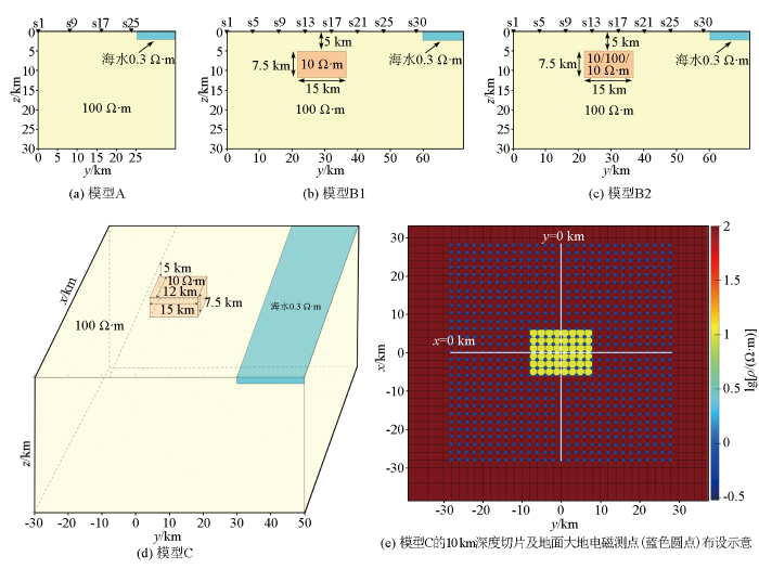
为了研究海岸效应对大地电磁测深数据的影响,本文设置了含海水100 Ω·m的半空间模型A、含海水100 Ω·m半空间内嵌一个10 Ω·m的二维电各向同性体模型B1、含海水100 Ω·m半空间内嵌一个二维轴向各向异性体(电各向异性体x、y、z三个主轴方向电阻率数值分别为10、100、10 Ω·m)模型B2以及含海水100 Ω·m半空间内嵌一个10 Ω·m的三维电各向同性体模型C(图1a~d)。对于二维的A、B1和B2模型,采用MARE2DEM系统[25]进行有、无海水情形下的正演计算,获得了测点间距为1 km的A模型25个剖面测点的响应函数、测点间距为2 km的 B1和B2模型31个剖面测点的响应函数,响应频率范围在70~0.000 5 Hz之间,对数域等间隔分为30个频点。对于三维模型C,采用ModEM系统[26-27]进行了有、无海水情形下的正演计算,获得了块体上方及周边共841个测点(图1e)的响应函数,测点间距为2 km,响应频率与二维模型一致。
图1
2.2 海岸效应影响下的大地电磁响应特征
对于模型A,不存在海水时,大地电磁响应的两支视电阻率曲线是重合的;当受到低阻海水的影响产生畸变时,两支视电阻率曲线会发生分离。图2主要统计了不同海水深度情形、距海水不同距离的测点处,两支视电阻率曲线发生分离的起始频率的变化。可以看出,在海水深度一定条件下,近海水的测点从高频开始受到海岸效应的畸变影响;而离海水较远的测点则从低频开始受到海岸效应的畸变影响;此外,海水深度的改变对视电阻率曲线发生畸变的起始频点范围影响不大。
图2
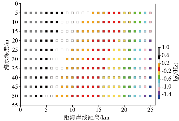
图2
模型A测点视电阻率曲线起始畸变频率随距海水距离和海水深度变化的统计
Fig.2
The initial distortion frequencies of apparent resistivity curves of MT sites in model A, changing with the site distance to sea water and the sea water depth
图3
图3
模型B1和B2在有、无海水情况下正演所得的相位张量和实感应矢量响应
a、c—分别是模型B1、B2在无海岸效应影响下的正演响应; b、d—相对应B1、B2在海岸效应影响下的正演响应
Fig.3
The phase tensor ellipses and real induction vectors from the models B1 and B2 with/without sea water
a、c—the responses from the models B1 and B2 without sea water; b、d—the responses from the models B1 and B2 with sea water
模型C在有、无海岸效应情形下的不同周期的归一化相位张量椭圆和实感应矢量响应如图4、5所示,椭圆中填充颜色指示扭曲角Ψ的大小,黄色(|Ψ|>6°)指示强烈的三维效应。相对于未受到海岸效应影响的相位张量(图4a、c、e、g),海岸效应会导致靠近海岸线区域短周期的相位张量由圆变成椭圆;随着周期增大到115.91 s时,区域内相位张量主轴指向北,扭曲角明显变大,且在南北两侧扭曲角的绝对值出现了大于6°的现象,这表明海岸效应会导致维数分析指示强烈的三维效应(图4b、d、f、h)。此外,相对于未受到海岸效应影响的实感应矢量(图5a、c、e、g),海岸效应会导致无法通过实感应矢量识别出三维异常体的平面位置(图5b、d、f、h)。
图4
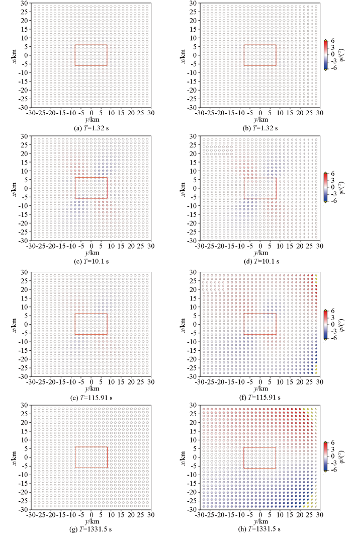
图4
模型C在有、无海水情况下正演所得不同周期的相位张量响应
a、c、e、g—模型C在无海水情况下不同周期的正演响应; b、d、f、h—模型C在有海水情况下不同周期的正演响应
Fig.4
The phase tensor ellipses of different periods from the model C with/without sea water
a、c、e、g—the responses of different periods from the model C without sea water; b、d、f、h—the responses of different periods from the model C with sea water
图5
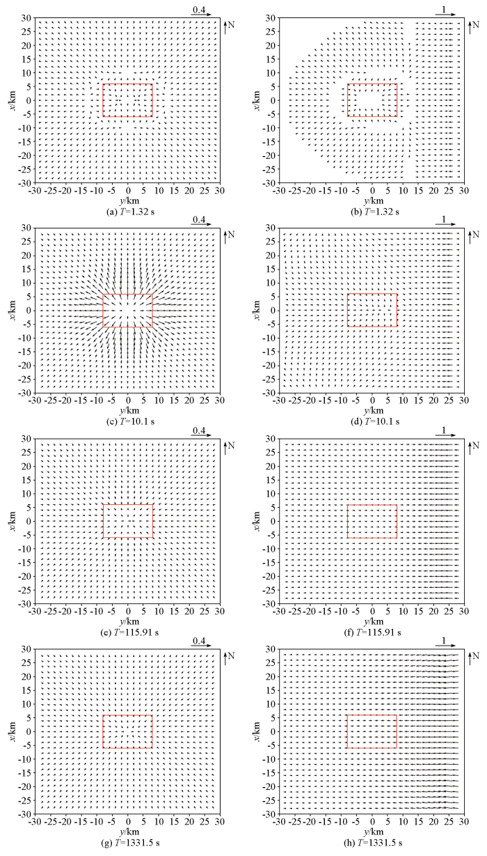
图5
模型C在有、无海水情况下正演所得的不同周期的实感应矢量响应
a、c、e、g—模型C在无海水情况下不同周期的正演响应;b、d、f、h—模型C在有海水情况下不同周期的正演响应
Fig.5
The real induction vectors of different periods from the model C with/without sea water
a、c、e、g—the responses of different periods from the model C without sea water; b、d、f、h—the responses of different periods from the model C with sea water
3 大地电磁反演
对B1模型响应进行了TE、TM以及TE+TM模式的各向同性反演,对B2模型响应进行了TE+TM模式的各向异性反演,视电阻率和相位的误差均设置为5%。对于模型C在有海水情形下的正演响应,进行了有、无海水约束的三维反演计算,反演数据集使用全阻抗数据集和倾子数据集,阻抗误差设置为5%´
3.1 不考虑海水影响的直接反演结果
图6
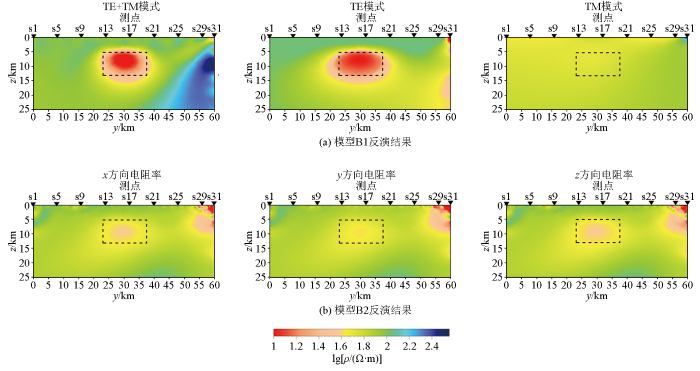
图6
模型B1(a)和B2(b)不考虑海水约束的二维反演结果
Fig.6
The 2D inversion results without sea water constraint for the responses of models B1 (a) and B2 (b)
图7
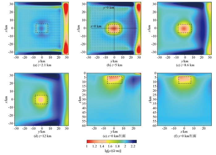
图7
模型C不考虑海水约束的三维反演结果
a~d—2.1 km、5 km、8.6 km和12 km深度处的水平切片结果;e—x=0 km处的剖面结果;f—y=0 km处的剖面结果。剖面平面位置见图b,黑色虚线框表示异常体,白色圆点为测点
Fig.7
The 3D inversion results without sea water constraint for the responses of model C
a~d—Horizontal tangents at depths of 2.1 km, 5 km, 8.6 km and 12 km; e—profile result at x=0 km; f—profile result at y=0 km. The locations of two profiles are indicated in b. The black dotted line indicates the location of anomaly body. The white dots represent site locations
3.2 考虑海水约束的反演结果
图8

图8
模型B1(a)和B2(b)考虑海水约束的二维反演结果
Fig.8
The 2D inversion results with sea water constraint for the responses of models B1 (a) and B2 (b)
图9
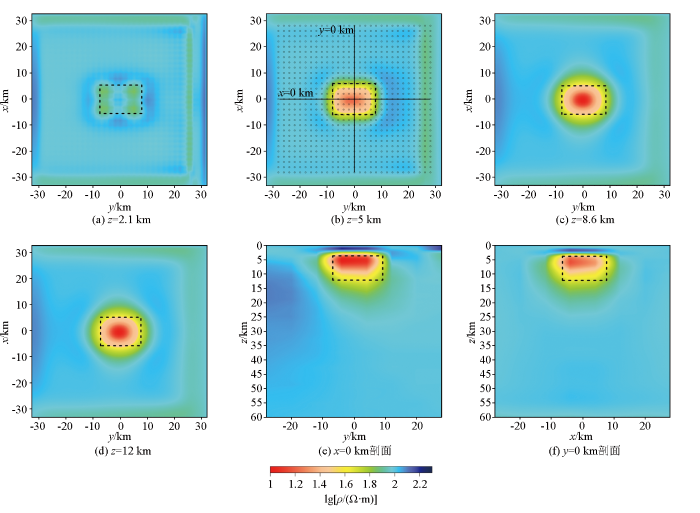
图9
模型C考虑海水约束的三维反演结果
a~d—2.1km、5km、8.6km和12km深度处的水平切片结果;e—x=0 km处的剖面结果;f—y=0 km处的剖面结果。剖面平面位置见图b,黑色虚线框表示异常体,白色圆点为测点
Fig.9
The 3D inversion results with sea water constraint for the responses of model C
a~d—Horizontal tangents at depths of 2.1 km, 5 km, 8.6 km and 12 km; e—profile result at x=0 km; f—profile result at y=0 km. The locations of two profiles are indicated in b. The black dotted line indicates the location of anomaly body. The white dots represent site locations
4 讨论
对于近海地区的大地电磁勘探,海岸效应对视电阻率曲线畸变影响的起始频率主要取决于测点到海岸线的距离。当海水深度一定时,大地电磁测深视电阻率曲线发生畸变的起始频点与测点离海岸线距离密切相关,近海水测点的视电阻率曲线在高频开始发生偏离,距离加大开始发生偏离的频率降低;海水深度的变化对视电阻率曲线偏离的起始频率影响不大。从本质上讲,大地电磁测深是基于平面电磁波趋肤深度理论的体积勘探方法,当测点与海岸线的距离小于某一频率的趋肤深度时,那么这一频率及以下频率的大地电磁响应将受到海岸效应影响而产生畸变[24]。某一测点处大地电磁测深视电阻率曲线发生畸变的起始频点(对应某一趋肤深度)主要由测点距海岸线的距离决定,而受海水深度的影响较小。
相对于无海岸效应的大地电磁响应,海岸效应导致大地电磁响应中包含了低阻海水产生的畸变信息,对实感应矢量影响较大,主要表现为靠近海水一侧的实感应矢量方向发生改变,随着频率的减小影响范围增大;此外,对于电各向异性异常体模型B2,实感应矢量无法指示异常体的位置。相位张量受畸变的影响相对较小,相位张量椭圆只是在靠近海水的高频段部分以及异常体近海水一侧会受到海岸效应影响,但对于三维模型C,相位张量扭曲角还会因为海岸效应的影响出现|Ψ|>6°的现象。
对含海岸效应的大地电磁测深数据反演时,考虑海水约束与否,对反演结果有很大的影响。不考虑海水约束时,二维各向同性模型B1响应的反演结果在近海水侧出现虚假异常。特别地,TM模式的单独反演无法恢复异常体,这是由于TM模式下电流垂直于构造方向,海洋中的电流更多地流向高阻陆地,引起TM数据产生比TE数据更强烈的畸变[16⇓-18]。对于二维电各向异性体模型B2,反演结果出现了由于海水的畸变作用导致近海水侧出现明显的虚假低阻异常,且恢复的异常体电阻率值与真实值有一定差异。对于三维各向同性模型C,三维反演结果显示海岸效应对异常体形态和电阻率值的恢复都存在一定的影响,且在靠近海水侧出现明显的高低阻相间的虚假异常。而考虑海水的约束反演,对由于低阻海水造成的虚假异常以及异常体难以准确恢复的问题,都有着显著的改善效果。
5 结论
本文通过大地电磁数值模拟,研究了海岸效应对大地电磁响应以及反演的畸变影响规律,得出了以下几点认识:
1) 海岸效应引起的视电阻率曲线发生畸变偏移的起始频率主要与测点到海岸线的距离有关,而海水深度的变化影响不大;
2) 海岸效应对大地电磁的低频响应产生强烈的畸变影响;
3) 低阻海水的存在会造成反演结果出现虚假异常,并会影响地下异常体的恢复;
4) 通过含海水约束反演,能够有效地压制海岸效应对反演结果产生的畸变影响。
参考文献
The relation of regional earthquakes to an intraplate volcano in the northern Hainan Island,China from magnetotelluric imaging
[J].
音频大地电磁法对隐伏构造的识别与应用——以河南省郑州市老鸦陈周边为例
[J].
Identification and application of audio magnetotellurics to the hidden structure:A case study of Laoyachen in Zhengzhou,Henan Province
[J].
音频大地电磁约束反演在地层识别中的应用:以哈密盆地为例
[J].
Constrained inversion of audio magnetotelluric for identifying strata:A case study in Hami Basin
[J].
基于AMT的龙首山成矿带西岔地段马路沟断裂带深部发育特征
[J].
Deep occurrence characteristics of the Malugou fault zone in the Xicha section of the Longshoushan metallogenic belt determined based on AMT
[J].
综合物探方法在云南澜沧老厂多金属矿区深部找矿中的应用
[J].
Application of integrated geophysical methods in deep ore prospecting of Laochang polymetallic mining area in Lancang,Yunnan
[J].
汝城盆地深部构造及地热资源赋存潜力——基于重力与AMT探测的认识
[J].
Gravity survey and audio magnetotellurics-based insights into the deep structures and geothermal resource potential of the Rucheng Basin
[J].
Geophysical evidence from the MELT area for compositional controls on oceanic plates
[J].
滩涂区综合地球物理调查技术在栟茶河断裂空间展布中的应用
[J].
Application of integrated geophysical survey technology in the spatial distribution of benchahe fault in Rudong mudflat area,Jiangsu Province
[J].
Correction of the sea effect in the magnetotelluric (MT) data using an iterative tensor stripping during inversion
[J].
海岸效应对近海地区大地电磁测深数据畸变作用研究
[J].
Ocean coast effect on land-side magnetotelluric data in the vicinity of the coast
[J].
Directions of rapid geomagnetic fluctuations
[J].
Geomagnetic effects of sloping and shelving discontinuities of earth conductivity
[J].
The perturbation of alternating geomagnetic fields by an island near a coastline:Reply
[J].
Irregular coastline and channeling effects in three-dimensional geomagnetic perturbation models
[J].
The geomagnetic coast effect
[J].
Electromagnetic induction in the oceans and inferences on the constitution of the earth
[J].
Coast effect distortion of marine magnetotelluric data:Insights from a pilot study offshore northeastern Japan
[J].
A newly distinguished marine magnetotelluric coast effect sensitive to the lithosphere-asthenosphere boundary
[J].
海岸效应对大地电磁响应的影响及校正方法
[J].
Study on the influence and correction method of coast effect on magnetotelluric responses
[J].
苏鲁超高压变质带北部地球物理调查(Ⅱ)——非地震方法
[J].
Geophysical investigation of northern Sulu uhpm terrane in East China (ⅱ):Non-seismic methods
[J].
Electrically anisotropic crust from three-dimensional magnetotelluric modeling in the western Junggar,NW China
[J].
琼北第四纪火山区电各向异性结构及其地质意义
[J].
Electrical anisotropic structure in the quaternary volcanic region of North Hainan Island and its geological implications
[J].
Electromagnetic induction effects at an ocean coast
[J].
Long-period magnetotelluric measurements near the central California coast:A land-locked view of the conductivity structure under the Pacific Ocean
[J].
MARE2DEM:A 2-D inversion code for controlled-source electromagnetic and magnetotelluric data
[J].
Computational recipes for electromagnetic inverse problems
[J].
ModEM:A modular system for inversion of electromagnetic geophysical data
[J].
The magnetotelluric phase tensor
[J].
Geomagnetische tiefentellurik teil II:Die streichrichtung der untergrundstrukturen des elektrischen widerstandes,erschlossen aus geomagnetischen variationen
[J].
