

0 引言
油页岩是重要的非常规油气资源,可以成为未来常规油气的重要补充或接替资源[1,2,3]。松辽盆地东北部油页岩分布较广,资源潜力大,是油页岩勘探开发的重要区域之一[4,5,6]。油页岩地球物理勘探以地震和测井方法为主[7,8,9,10,11]。随着经济社会的发展,为了顺应绿色发展理念,适应生态环境保护需求,“绿色”勘探技术要求越来越迫切。地球表面即便在没有发生可感知的地震事件时也一直存在着震动,称为地震环境噪声(微动)。微动信号中面波能量占比约2/3,可以利用面波特性反演地下介质横波速度信息。微动勘探通常利用以一定方式布设的微动观测台阵采集地面的天然微动信号,通过数据处理提取面波频散曲线,反演得到地下介质横波(S波)速度结构。地震环境噪声(微动)勘探方法已经在场地效应评估、断层与溶洞探测、地壳速度结构探测等领域得到了广泛的应用[12,13,14,15,16,17,18,19,20,21,22,23]。根据领域的不同,探测深度从几十米到数千米。油气储层由于是孔隙多相介质,对横波速度具有敏感性,因此,利用微动探测方法进行油气储层探测具有可行性。同时,微动探测由于不需要震源,相对传统的反射地震等储层勘探方法,其具有环保优势。
空间自相关(SPAC)法[24]和频率波数域(FK)法[25]是微动勘探最常用的两种从微动信号中提取面波频散曲线的方法。FK方法在早期研究中得到了广泛关注[25,26,27,28,29]。有研究表明,当利用任意形状阵列观测的短周期微动数据提取瑞利面波相速度时,SPAC方法比FK方法更精确[30]。SPAC方法首先由Aki于1957 年提出,数据采集观测系统由圆环均匀分布阵列和中心台站组成[24,31]。因为在城市街道等特定的环境中,很难布置满足严格圆环形的阵列,不得不采用如“L”、“T”或直线形台阵[26],这制约了SPAC方法在早期的推广,只有少数学者进行了应用。为了克服SPAC方法严格观测系统带来的局限,许多学者对SPAC方法进行了发展。Ling和Okada提出了扩展空间自相关方法(ESPAC),该方法允许设计任意形状的阵列[32]。Betting等修正了SPAC方法(MSPAC),该方法利用一定半径范围(如r1~r2)的台站数据提取面波频散曲线[33]。2001年,Louie在处理一维线性排列的微动信号时,发展了折射微震阵(REMI)方法[34],取得了不错的应用效果[35,36]。Cho等提出了一种无中心环形微动探勘方法(CCA),并利用谱比函数分析提取面波频散曲线[37,38]。研究表明,在随机噪声源空间均匀分布时,在时间域对不同观测时段的台站对相关数据进行平均,其效果与环形台站的空间方位平均等价[39]。Okada研究了SPAC方法中圆环形台阵的台站数量对探测效果的影响,认为3个台站是最高效的[40]。Shabani等拓展了MSPAC方法(EMSPAC),将离散和近似连续圆形阵列的SPAC公式扩展到处理具有规则和不规则方位间距的阵列[41],利用圆形台阵的水平极化噪声扩展方法更加有效地提取了瑞利波[42]。主动源面波的多道分析(MASW)思路也逐渐被引入到微动勘探中,被称为被动源MASW方法[43,44,45,46]。微动勘探与主动源面波联合勘探在浅地表探测中也越来越受到重视[47,48]。Hayashi等将主动源面波勘探中的共中心点成像思想[49,50]引入微动勘探,建立了共中心点空间自相关(CMP-SPAC)微动勘探方法[51,52,53,54,55]。本文将Hayashi等提出的共中心点SPAC方法中的共中心点概念延拓至共中心面元,利用灵活观测系统,首次基于CMP-SPAC方法,将微动勘探应用于油页岩勘探,在松辽盆地开展了试验研究,取得了较好的效果。
1 CMP-SPAC方法
图1
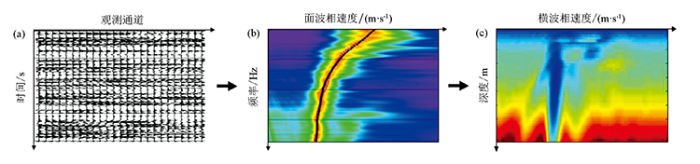
图1
微动勘探基本原理示意
a—地震环境噪声;b—面波频散;c—横波速度结构
Fig.1
Bisic principle of microtremor survey method
a—seismic ambient noise;b—surface wave dispersion;c—shear wave velocity
图2
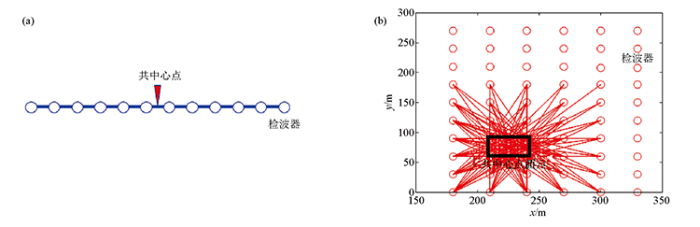
图2
CMP-SPAC方法观测系统示意
a—线性共中心点观测系统;b—二维共中心面元观测系统
Fig.2
Geometry of CMP-SPAC method
a—linear common center observation systerm;b—two dimensional common center unit observation systerm
2 数据采集
试验区位于松辽盆地北部,试验区内主要为沉积地层,主要由第四系黄土和黑色腐殖土、泥岩、砂岩等组成。试验区电阻率很低,电磁场衰减严重,利用电磁方法获得有效的深部信息比较困难。因此,本文针对该测区特殊的地质地球物理条件,开展微动勘探试验研究,以便发展适用于松辽盆地油页岩探测的“绿色”地球物理方法,达到能源勘探目标。
本次微动勘探使用36套Atom单道无线地震仪,并搭配2 Hz高灵敏度检波器(图3a)。一致性试验表明,不同台站之间具有很好的一致性(图3b)。根据CMP-SPAC微动勘探方法基本原理,观测系统布置应满足检波器对射线及其中心位置分布相对均匀,以保障每个共中心面元成像所用微动数据的数据量及其台阵半径分布基本一致。本次油页岩微动勘探试验设计观测系统由主排列和垂直辅助排列组成。主排列由24个观测台站组成线性排列,2条辅助排列各由6个观测台站组成,垂直主排列分布(图4)。观测台站间距为50 m。每次观测1 h后,观测台阵沿测线滚动6个台站间距(图4),设计7次滚动。为保证数据质量,检波器采用浅坑埋置。实际观测站位分布如图5所示, 包含7个共观测时间台阵(图5)。该观测系统布设简单,可根据实际地质、地形条件灵活调整,检波器对射线(图5a)及其中心点位置(图5b)分布较均匀,保障了观测台站分布的空间覆盖,利于获得高质量的微动数据。图5a中,圆圈表示观测台站,线段表示两两检波器对射线。图5b中,圆圈表示两两检波器对射线的中心位置。
图3
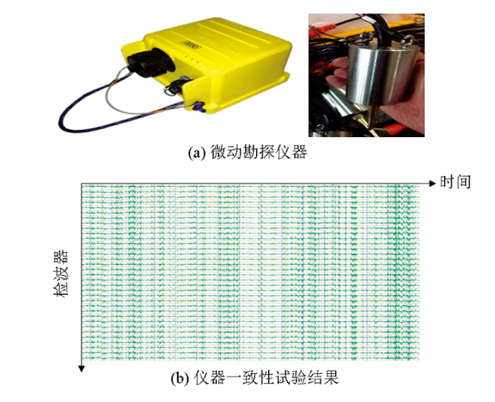
图4
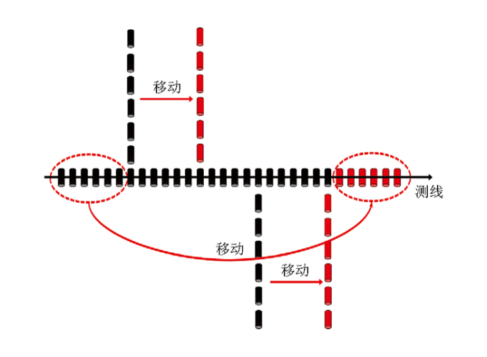
图5
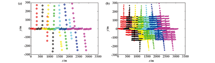
图5
实际观测系统(7种颜色代
a—检波器位置分布;b—检波器对中心位置分布
Fig.5
Actual geometry (the seven colors represent the seven array observations)
a—gephone position distribution;b—center position of geophone pairs distribution
3 CMP-SPAC频散曲线提取
CMP-SPAC方法利用台阵半径范围内,中心位置相同的检波器对微动数据,通过SPAC方法计算面波频散曲线。本文将共中心点概念拓展至共中心面元,利用中心位置位于同一成像面元范围的检波器对微动数据,通过SPAC方法计算面波频散曲线。根据本次试验研究的检波器对中心点的分布,检波器对中心在垂直测线方向-150~150 m范围内分布密度较大,在该条带范围内划分共中心面元。沿测线方向共中心面元的大小应保障在面元范围内落入足够的检波器对中心点,以保障足够的地震台站观测数据参与到面波频散曲线计算。沿测线方向,划分31个共中心面元,面元为150 m×300 m矩形区域,相邻成像面元之间沿测线方向存在50 m范围的重叠(图6a)。利用中心位于成像面元范围的检波器对(图6b)所接收的微动数据计算该成像面元的频散曲线,作为该成像面元中心位置的频散曲线输出。图6b是第21个面元频散曲线计算所用到的检波器及其两两之间的连线。第21个面元共用到3次台阵观测数据(3种颜色代表3次台阵观测)。
图6
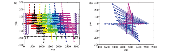
图6
共中心面元
a—共中心面元(紫色虚线方框)划分;b—第21个共中心面元所用的检波器及其检波器之间的射线分布
Fig.6
Common center unit
a—division of common center unit(purple dotted box);b—the ray distribution between the detectors used for the 21st common center unit
对每个共中心面元,采用SPAC方法计算频散曲线。假设f、g为两个检波器微动记录,则它们的频率域相关记录CCfg(ω)可以表示为:
式中:Af(ω)为、Ag(ω)为f、g的振幅频谱;r为检波器对之间的距离。则两道噪声记录的相关系数COHfg(r,ω)可以表示为:
Re(·)代表取实部。对相关系数进行空间方位积分后可表示为贝塞尔函数:
图7
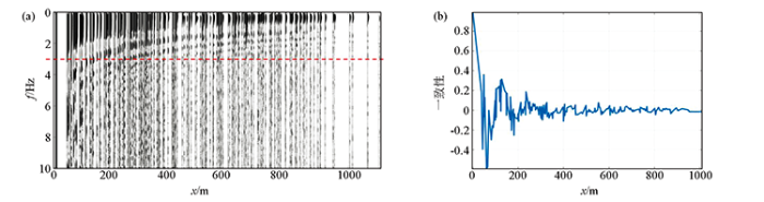
图7
相关系数
a—某面元的相关系数;b—3 Hz波的相关系数
Fig.7
Coherence coefficient
a—coherence coefficient of a common center unit;b—coherence coefficient of 3 Hz wave
图8
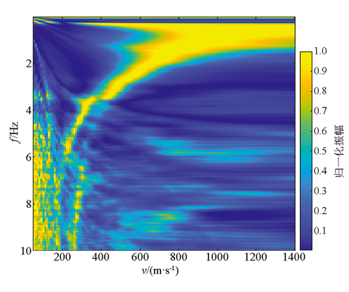
4 视横波速度剖面
图9
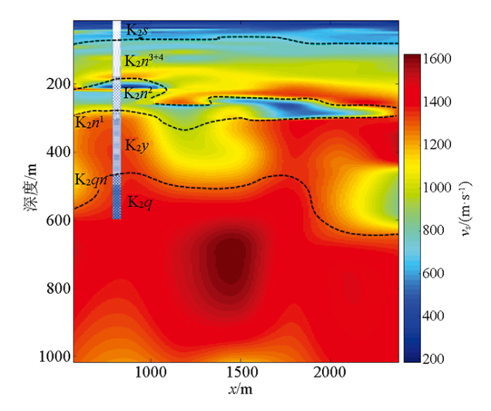
式中:vr,i为第i个频率值的面波速度;ti为第i个频率值对应的周期;vx,i为第i个频率值的视横波速度。视横波速度既不同于面波速度,也不同于横波速度,具有速度量纲,根据式(4)计算视横波速度能避免反演多解性,同时能客观地反映地层岩性的速度变化[56],深度采用半波长深度。
表1 钻孔编录信息
Table 1
| 地层 | 符号 | 厚度/m | 特征 | |||
|---|---|---|---|---|---|---|
| 系 | 统 | 组 | 段 | |||
| 第四系 | Q | 15.9 | 黄土、腐殖土、散砂、砂砾 | |||
| 白垩系 | 上统 | 四方台组 | K2s | 62.8 | 棕红色泥岩、粉砂质泥岩与灰白、灰绿色粉砂岩、砂岩互层 | |
| 嫩江组 | 嫩三、四段 | K2n3+4 | 106 | 灰绿、灰白、灰色砂岩、粉砂岩,浅灰色、暗色泥岩 | ||
| 嫩二段 | K2n2 | 105.2 | 灰黑泥页岩,含油页岩,重要标志层 | |||
| 嫩一段 | K2n1 | 18.6 | 砂岩、砂砾岩夹泥岩 | |||
| 姚家组 | K2y | 163.5 | 灰绿色泥岩、灰白色钙质粉砂岩 | |||
| 青山口组 | K2qn | 28 | 灰色泥岩、黑褐色油页岩互层 | |||
| 泉头组 | K2q | 浅灰色细砂岩、棕/紫红色泥岩互层 | ||||
5 结论
本文将共中心点空间自相关微动勘探方法中的共中心点概念延拓至共中心面元,基于地震台阵监测的地震环境噪声数据,将微动勘探应用于油页岩勘探,在松辽盆地开展了试验研究。研究结果表明:CMP-SPAC微动勘探方法观测系统灵活,得到的横波速度剖面结合钻孔资料能很好地标识、划分研究位置的主要地层,与测线附近钻孔编录结果对应较好,主要油页岩地层——标志层白垩系嫩江组二段呈现出低速度异常特征。共中心面元空间自相关微动勘探方法具有成为更符合“绿色发展”要求的油页岩新地震勘探方法。
参考文献
松辽盆地北部嫩江组一段油页岩测井识别
[J].
The identification of oil shale logging of the first member of nenjiang formation in northern songliao basin
[J].
松辽盆地北部油页岩资源潜力评价
[J].
Resource potential evaluation of oil shale in North Songliao Basin
[J].
松辽盆地东南隆起区白垩系嫩江组一段沉积相、旋回及其与松科1井的对比
[J].
Sedimentary facies and cyclostratigraphy of the Cretaceous first member of Nenjiang Formation in the Southeast uplift zone, Songliao Basin and its correlation with the CCSD-SK-I
[J].
松辽盆地东南缘地浸砂岩型铀矿成矿条件分析
[J].
Analysis of metallogenic conditions of In-Situ Leachable sandstone type Uranium eposit in the Southeastern Margin of Songliao Basin
[J].
松辽盆地青山口组一段油页岩成矿条件及有利目标区分析
[J].
Analyses of forming condition and favorable area of oil shale in the 1st member of Qingshankou Formation,Songliao Basin
[J].
松辽盆地油页岩勘探开发有利区预测
[J].
Favorable areas prediction for oil shale exploration and exploitation in Songliao basin
[J].
小型可控震源在油页岩地震勘探中的应用试验
[J].
Experiment and application of mini vibrators seismic exploration in Oil Shale
[J].
油页岩的地球物理识别和评价方法
[J].
A geophysical method for the identification and evaluation of oil shale
[J].
油页岩勘探开发现状及进展
[J].
The present situation and progress of oil shale exploration and exploitation
[J].
油页岩的地震识别与评价技术
[J].
A seismic technique for recognition and evaluation of oil shale
[J].
油页岩地球物理测井方法技术综述
[J].
Review of geophysical logging technique for oil shale
[J].
微动勘探技术及其在土木工程中的应用
[J].
Array microtremor survey and its application to civil engineering
[J].
用微动中的面波信息探测地壳浅部的速度结构
[J].
To determine the velocity structure of shallow crust with surface wave information in microtremors
[J].
New features in the subsurface structure model of EI Hierro island (Canaries) from low-frequency microseismic sounding:An insight into the 2011 Seismo-Volcanic crisis
[J].
Estimating Cenozoic thickness in the Beijing plain area using array microtremor data
[J].
二维微动剖面探测“孤石”:以深圳地铁7号线为例
[J].
Mapping spherically weathered “Boulders” using 2D microtremor profiling method: A case study along subway line 7 in Shenzhen
[J].
微动探测:地层分层和隐伏断裂构造探测的新方法
[J].
Microtremor survey method:A new geophysical method for dividing strata and detecting the buried fault structures
[J].
土石混合滑坡体微动探测:以衡阳拜殿乡滑坡体为例
[J].
Microtremor survey of soil-rock mixture landslides:An example of Baidian township,Hengyang City
[J].
覆盖区岩溶溶洞的微动探测试验研究——以福建永安大湖盆地为例
[J].
Application of 2D microtremor section survey method in covered karst area, taking Yongan Dahu Basin,Fujian Province as example
[J].
Local site effects evaluation for Atbara area using microtremor measurement
[J].
Application of the spatial auto-correlation method for shear-wave velocity studies using ambient noise
[J].
南北地震带岩石圈 S 波速度结构面波层析成像
[J].
Lithospheric S-wave velocity structure of the North-South seismic belt of China from surface wave tomography
[J].
基于微动方法研究五大连池火山区尾山火山锥浅层剪切波速度结构
[J].
Shallow shear-wave velocity structures under the Weishan volcanic cone in Wudalianchi volcano field by microtremor survey
[J].
Space and time spectra of stationary stochastic waves, with special reference to microtremors
.[J].
High-resolution frequency-wavenumber spectrum analysis
[J].
Array estimators and the use of microseisms for reconnaissance of sedimentary basins
[J].
Comparison of spatial autocorrelation method and frequency-wavenumber spectral method of estimating the phase velocity of Rayleigh waves in long-period microtremors
[R].
Estimation of underground structure at higashinada ward,kobe using surface wave of microtremor and explosion record
[J].
Estimation of S-wave velocity structures in and around the Sendai Basin,Japan,using array records of microtremors
[J].
Comparison of ESAC and FK methods of estimating phase velocity using arbitrarily shaped microtremor arrays
[J].
The use of microseisms in geophysical exploration
[D].
An extended use of the spatial autocorrelation method for the estimation of structure using microtremors
[C]//
Analysis of dense array measurements using the modified spatial auto-correlation method (SPAC):Application to Grenoble area
[J].
Faster,better:shear-wave velocity to 100 meters depth from refraction microtremor arrays
[J].
Blind shear-wave velocity comparison of ReMi and MASW results with boreholes to 200 m in Santa Clara Valley:Implications for earthquake ground-motion assessment
[J].
Measurement of shallow shear wave velocities at a rock site using the ReMi technique
[J].
A new method to determine phase velocities of Rayleigh waves from microseisms
[J].
A generic formulation for microtremor exploration methods using three-component records from a circular array
[J].
An alternative approach to the SPAC analysis of microtremors:Exploiting stationarity of noise
[J].
Theory of efficient array observations of microtremors with special reference to the SPAC method
[J].
An extended MSPAC method in circular arrays
[J].
The SPAC method for a finite M-station circular array using horizontally polarized ambient noise
[J].
Imaging dispersion curves of passive surface waves
[C]//
Multichannel analysis of surface waves (MASW)-active and passive methods
[J].
A new passive seismic method based on seismic interferometry and multichannel analysis of surface waves
[J].
A state-of-the-art review of passive MASW survey for subsurface profiling
[J].
Combined use of active and passive surface waves
[J].
Shear-wave velocity structure from MASW and SPAC methods.The case of Adra town,SE Spain
[J].
CMP analysis of multi-channel and multi-shot surface-wave data
[J].
CMP cross-correlation analysis of multi-channel surface-wave data
[J].
Estimation of near surface shear wave velocity using CMP cross-correlation of surface waves (CCSW)
[C]//
Multi-channel analysis of surface waves (MASW) using CMP analysis to identify soil problems threat on the heritage site at Georgetown,Malaysia
[C]//
CMP stacking for multi-channel analysis of single-shot surface wave data
[C]//
CMP spatial autocorrelation analysis of multichannel passive surface-wave data
[C]//
Active fault investigation by 3D ambient noise tomography in Hebei province,China
[C]//
Mapping deeply buried geothermal faults using microtremor array analysis
[J].
