

0 引言
影响土壤中硒含量因素较多,前人对其进行了较为详细的研究,不同地区具有不同的影响因素。王甘露等[10]研究发现贵州土壤中硒含量主要受基岩硒含量制约;王美珠等[11]认为母岩类型是影响土壤硒含量的主要原因,生物、气候、地形等对土壤硒含量也起着一定作用;还有部分学者认为人类活动是高硒土壤形成过程中不可忽略的重要因素[12,13],大气硒的沉降和挥发是影响中土壤硒分布的重要因素[14,15];魏明辉[16]等发现燃煤也是土壤中硒含量重要影响因素;Umesh等[17]认为成土母质、气候、土壤质地、有机质及人为因素影响土壤硒含量;Malisa等[18]认为沉积岩中的黏土与有机质含量使得硒含量增加。可见土壤中硒含量的影响因素较多,较为复杂,综合分析可以看出,主要为3个因素:一是硒来源影响,例如基岩含量、成土母质含量、大气沉降影响等;二是土壤中理化指标的影响,例如土壤中元素、有机质、黏粒含量等;三是人为因素影响,例如人工施肥等。
三江平原作为全国重要粮食产区,其富硒土地中硒的分布特征、含量影响因素对当地的特色农业规划及可持续发展具有重要意义。笔者利用三江平原西部近2万km2表层土壤(0~20 cm)及深层土壤(150~200 cm)地球化学数据,总结三江平原西部地区土壤中硒的分布特征,并利用统计学的相关性分析、因子分析及聚类分析等方法对三江平原土壤中硒含量的主要影响因素进行分析。
1 材料与方法
1.1 研究区概况
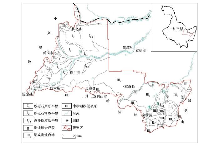
研究区位于三江平原西部与南部,北部以黑龙江为界,东、南、西三面分别被完达山、那丹哈达岭、小兴安岭所环抱,主地势低平,沼泽湿地发育[21]。研究区位置见图1。研究区内发育的主要河流为黑龙江、松花江,以及发育于小兴安岭的鸭蛋河、嘟噜河及乌苏里江的支流七星河、挠力河等,其中挠力河流域分布许多发育于东部完达山山脉的支流。研究区内岩性主要为第四系沉积物,以砂性土和黏土为主,基岩出露较少,多以残丘突兀于平原中。研究区主要包括6个地貌单元,分别为湖成的剥蚀台地(Ⅲ1)、冲积湖积低平原(Ⅲ2)、泥砂砾质低平原(Ⅰ3-2)、砂砾石河谷平原(Ⅰ3-1)、砂砾石扇形平原(Ⅰ2)、火山地貌形成的剥蚀熔岩丘陵(Ⅱ),土壤质地与地貌单元对应较好,其中Ⅲ1、Ⅲ2、Ⅱ地貌以黏性土为主,其他地貌单元以砂性土为主。各地貌分布详见图1。
图1
1.2 样品采集
土壤硒数据来源为东北黑土地1∶25万土地质量地球化学调查项目,样品按照《多目标区域地球化学调查规范(1∶250 000)》(DZ/T 0258—2014)布点与采集。浅层样品采集为1件/km2,每个样品由3个采样坑内垂直采集0~20 cm土柱组合形成,测试分析时4个样品组合为一个分析样,即每4 km2一个分析数据。深层样品采集150~200 cm处的深层土壤,采样密度为1件/4 km2,4个样品组合为一个深层分析样品,即每16 km2一个分析数据,共取得 4 287 组浅层分析数据以及1 404组深层分析数据。
1.3 样品测试
样品分析测试由河北省地矿中心实验室承担,共分析包括Se在内的54种地球化学指标,分析方法及配套方案、准确度、精密度和检出限等均满足《多目标区域地球化学调查规范(1∶250 000)》(DZ/T 0258—2014)规定要求,其中硒测试方法采用原子荧光法。
1.4 数据处理
数据统计分析以及地球化学图的绘制主要利用化探数据处理一体化系统GeoChem Studio,因子分析、聚类分析以及相关性分析利用IBM SPSS Statistics 20.0 软件进行。
2 结果与讨论
2.1 土壤硒分布特征
表1 表层土壤与深层土壤硒元素统计值
Table 1
| 类型 | 样品数 | 均值/10-6 | 最小值/10-6 | 最大值/10-6 | 中位数/10-6 | 标准离差 | 变异系数 |
|---|---|---|---|---|---|---|---|
| 表层土壤 | 4287 | 0.25 | 0.06 | 2.27 | 0.23 | 0.1 | 0.39 |
| 深层土壤 | 1404 | 0.11 | 0.02 | 2.03 | 0.1 | 0.07 | 0.67 |
根据我国硒元素生态监管界限值[23],将土壤硒含量分为硒不足(<0.125×10⁻⁶)、硒潜在不足(0.125×10⁻⁶~0.175×10⁻⁶)、足硒(0.175×10⁻⁶~0.40×10⁻⁶)、富硒(0.40×10⁻⁶~3.0×10⁻⁶)、硒中毒(>3.0×10⁻⁶)5个等级。以5个等级为分界线作表层与深层土壤硒元素地球化学图(图2),可以看出表层土壤硒含量以足硒为主,富硒土壤主要分布于研究区东部的完达山至挠力河中间的冲积湖积低平原地区(Ⅲ2)以及萝北县北部湖成剥蚀台地(Ⅲ1)地区;潜在硒不足以及硒不足地区主要沿松花江河流以及研究区北部分布;深层土壤硒含量以硒不足为主,未见富硒土壤,但在完达山与小兴安岭山前均出现了由山前至平原硒含量由足硒—硒潜在不足—硒不足递减的分布特征。
图2
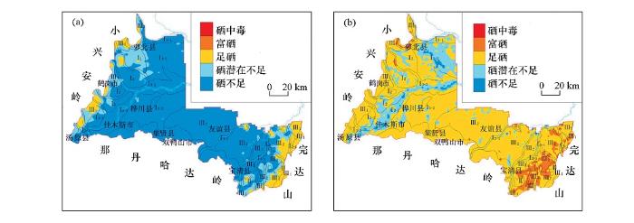
图2
三江平原西部深层土壤(a)与表层土壤(b)硒分布特征
Fig.2
Distribution of selenium content in deep soil(a) and surface soil(b) in west Sanjiang plain
2.2 表层土壤中硒含量影响因素
2.2.1 地貌及土壤质地的影响
通过地球化学图(图2b)可以看出,表层土壤中硒含量高值区主要出现在湖成砂黏土质台地(Ⅲ1)、火山地貌玄武岩丘陵(Ⅱ)以及挠力河流域的冲积湖积黏土质低平原地区(Ⅲ2),其中在后者形成大面积富硒土壤,硒含量低值区主要出现在松花江干流形成的砂砾石河谷平原以及研究区北部黑龙江古河道地区。杨湘奎等[21]通过对三江平原土壤岩性划分发现,不同地貌单元土壤中黏土含量不同。按不同地貌单元对土壤硒含量进行统计,各地貌类型及主要土壤岩性区土壤硒含量详见表2。可以看出变异系数最高的为砂砾石河谷平原,导致变异系数较大的主要原因是松花江干流形成的河谷平原土壤中硒含量较低,而各支流形成的主要河谷平原硒含量较高。由表层土壤岩性分布概况(表2)可以看出,硒含量高值区的地貌(Ⅲ1、Ⅲ2)土壤主要以黏性土为主,低值区的地貌则主要以砂砾岩性土为主,分析其原因为湖成地貌土壤中黏土含量高,黏土对硒具有明显的吸附作用[20,24]。因此三江平原地区湖成地貌易于形成富硒土地,主要因为湖成地貌土壤质地黏土含量较高,利于硒元素的吸附。
表2 各地貌单元表层土壤中硒元素含量统计值
Table 2
| 地貌单元 | 土壤岩性 | 样品数 | 最小值/10-6 | 最大值/10-6 | 算术平均值/10-6 | 变异系数 |
|---|---|---|---|---|---|---|
| Ⅰ2 | 含泥质砂砾石 | 281 | 0.12 | 0.46 | 0.2 | 0.22 |
| Ⅰ3-2 | 泥砂砾质 | 1164 | 0.09 | 0.69 | 0.2 | 0.3 |
| Ⅰ3-1 | 砂砾石 | 799 | 0.06 | 0.88 | 0.23 | 0.44 |
| Ⅲ2 | 粉质黏土 | 1256 | 0.06 | 0.63 | 0.28 | 0.31 |
| Ⅱ | — | 20 | 0.2 | 0.51 | 0.31 | 0.23 |
| Ⅲ1 | 粉质黏土 | 767 | 0.12 | 1.33 | 0.31 | 0.31 |
注:“—”表示土壤岩性不明。
2.2.2 成土母质影响
表4 研究区表层土壤主因子载荷
Table 4
| 指标 | 成分 | ||
|---|---|---|---|
| F1 | F2 | F3 | |
| Ni | 0.85 | 0.17 | 0.11 |
| Cr | 0.83 | 0.26 | 0.09 |
| V | 0.81 | 0.10 | 0.09 |
| Sc | 0.81 | 0.16 | 0.27 |
| Cu | 0.80 | 0.35 | 0.02 |
| Ti | 0.66 | -0.06 | -0.06 |
| Fe2O3 | 0.66 | 0.07 | 0.32 |
| Na2O | -0.65 | -0.40 | -0.19 |
| K2O | -0.58 | -0.51 | 0.26 |
| Ge | 0.42 | -0.30 | 0.40 |
| C | 0.16 | 0.93 | 0.00 |
| Corg | 0.20 | 0.92 | 0.01 |
| N | 0.28 | 0.90 | -0.01 |
| S | 0.14 | 0.84 | 0.03 |
| Se | 0.34 | 0.46 | -0.05 |
| U | -0.04 | 0.42 | 0.39 |
| Rb | 0.01 | -0.13 | 0.85 |
| Tl | -0.24 | 0.02 | 0.81 |
| Al2O3 | 0.26 | -0.09 | 0.76 |
| Ga | 0.42 | 0.11 | 0.74 |
| Be | 0.06 | 0.06 | 0.73 |
| Li | 0.43 | 0.24 | 0.65 |
| F | 0.35 | 0.24 | 0.58 |
2.2.3 其他理化指标影响
表3 研究区表层土土壤因子方差贡献率
Table 3
| F1 | F2 | F3 | F4 | F5 | F6 | F7 | F8 | F9 | |
|---|---|---|---|---|---|---|---|---|---|
| 方差贡献率/% | 15.516 | 11.302 | 10.802 | 8.127 | 8.115 | 7.254 | 4.811 | 4.046 | 3.248 |
| 累积方差贡献率/% | 15.516 | 26.819 | 37.621 | 45.748 | 53.862 | 61.117 | 65.927 | 69.973 | 73.221 |
对因子分析中第二因子中的元素进行聚类分析[25],以进一步筛选出影响硒的最主要因素。由聚类分析图谱(图3)可以看出,C、Corg、N与S聚为一类,然后与Se聚为一类。其中,N与Corg、C聚为一类主要是因为现代沉积中,有机质是N的主要来源[26,27],因此认为N与Se聚为一类是有机质因素的影响。Se属于亲硫元素,与S聚为一类是因为两者地球化学相似性。宋铁军[28]指出研究区富硒土壤硒主要来源为完达山花岗岩,因此硒的富集不是生物循环的结果,是有机质对硒的吸附作用的结果。对硒有机质、氧化物以及pH等理化指标进行Person相关性分析(表5),Se与有机质、Fe2O3、Mn、MgO为显著正相关,表明土壤中有机质、铁、锰等氧化物对硒具有吸附作用,尤其是有机质具有明显的吸附作用。K2O、NaO与Se为显著负相关系,且硒低值区与这两种元素高值区空间分布吻合。硒含量与pH具有显著相关性,这与前人研究结果[7]一致,说明土壤中Se含量与pH值有关,但对硒含量影响不大。
图3
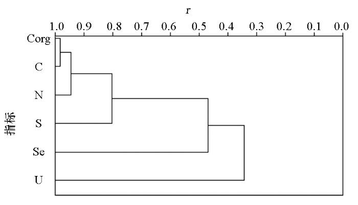
表5 表层土壤硒与各理化指标的相关系数
Table 5
| 元素 | 有机质 | pH | MgO | Na2O | SiO2 | Al2O3 | CaO | Fe2O3 | K2O | Mn |
|---|---|---|---|---|---|---|---|---|---|---|
| 相关系数 | 0.425** | 0.039** | 0.124** | -0.508** | -0.013 | -0.175** | 0.017 | 0.297** | -0.512** | 0.205** |
注:“** ”为 (p<0.01)显著相关。
2.3 土壤硒生物有效性分析及土壤环境质量评价
土壤环境质量评价主要对重金属元素进行综合评价,采用最大限制原则,每个评价图斑的土壤环境地球化学综合等级等同于单指标划分出的环境等级最差的等级。本次评价选取Cd、 Hg、As、 Pb、 Cr、 Cu、 Ni、 Zn等重金属元素为评价单项指标,对每个重金属元素进行单因子指标评价,综合考虑土壤用地类型和土壤酸碱度,根据国家最新发布的《土壤环境质量 农用地土壤污染风险管控标准》(GB 15618—2018)中给出的风险筛选值和管制值,进行单指标土壤环境地球化学等级划分。根据以上划分等级原则,将研究区环境质量划分为无风险、风险可控、风险较高3个等级,统计结果见表6,其中无风险占比99.81%,说明研究区整体土壤环境质量良好,是非常清洁的土地资源,0.19%的风险可控区零星分布,主要位于友谊县以及萝北县城附近。研究区富硒地区均为无风险区,是当地发展现代绿色富硒农业的物质基础。
表6 土壤环境质量化学综合等级统计
Table 6
| 等级 | 无风险区 | 风险可控 | 风险较高 |
|---|---|---|---|
| 点数 | 4279 | 6 | 0 |
| 比例/% | 99.81 | 0.19 | 0.00 |
3 结论
1) 三江平原西部表层土壤硒含量高于黑龙江省硒含量均值,达到0.25×10⁻⁶,表层土壤硒含量多处于足硒等级(w(Se)>0.3×10⁻⁶),硒潜在不足或硒不足地区主要沿松花江河流两岸以及黑龙江古河道展布。富硒土壤主要分布于完达山至挠力河中间的冲积湖积低平原地区,同时在萝北县城北部冲湖积台地地区有小面积分布。
2) 因子分析、聚类分析等统计分析认为,影响三江平原土壤中硒含量最主要指标为土壤有机质,同时土壤中其他理化指标对土壤中硒含量也起到一定作用,铁、锰等氧化物对硒具有一定吸附作用,而K2O、NaO对硒具有明显的贫化作用,土壤pH对硒含量影响作用较小。成土母质的硒含量与土壤中硒含量具有显著的低相关性,说明成土母质是影响表层土壤中硒含量的一个重要因素,但不是主要因素。
3) 表层土壤中硒的分布特征受地貌影响较大,其原因为不同地貌单元黏土含量不同。黏土对硒起到吸附作用,因此黏土含量较高的湖成地貌更利于硒的富集,而砂砾含量较高的松花江河流两岸以及黑龙
江古河道硒含量较低。
4) 富硒地区生物有效硒以水溶态硒、 离子交换态硒、碳酸盐结合态硒为主,占硒总量的5%,大豆富硒率达到50%,水稻富硒率达到44%。土壤环境质量综合评价显示三江平原地区多为无风险区,仅个别污染点零星分布,富硒地区均为无风险区,是一块珍贵的清洁土地资源,当地可依托富硒土地发展绿色富硒农业。
参考文献
我国土壤表层硒含量的地理分布及其与人畜硒反应病的关系
[J].
Geographical distribution of selenium content in the top soils in China and it’s association with selenium-reoponsive diseases in man and animal
[J].
克山病与环境硒等生命元素的关系
[J].
The relationship between Keshan disease and environmental selenium and other life elements
[J].
黑龙江省土壤硒(Se)元素背景值与地方性疾病的关系
[J].
Relation between Se background values and endemic diseases in Heilongjiang Province
[J].
大骨节病区硒元素分布的调控机理研究——以四川省阿坝地区为例
[J].
Study on the regulatory mechanism of selenium distribution in Kashin-beck disease areas: A case study of aba area, Sichuan Province
[J].
The elemental composition of soils environmental chemistry(2nd Ed)
[M].
低硒带土壤中硒的挥发过程研究
[J].
Selenium evaportion from soils of Chinese Se-defficient belt
[J].
东北平原土壤硒分布特征及影响因素
[J].
Distribution of soils selenium in the Northeast China Plain and its influencing factors
[J].
土地质量地球化学平价方法研究与应用:以黑龙江省宏胜镇为例
[J].
The study and application of land quality geochemical evaluation method: Illustrated by the case of Hongsheng town, Heilongjiang Province
[J].
三江平原富Se地区地下水—土壤—农作物中Se富集规律及影响因素
[J].
Enrichment regularities and influence factors of selenium in groundwater-soil-crop seeds at a Se-rich area of the Three River Plain, China
[J].
贵州省土壤硒的背景值研究
[J].
Background value of selenium in soil of Guizhou Province
[J].
我国部分高硒低硒土壤的成因初探
[J].
A discussion on the cause of high-Se and low-Se soil information
[J].
恩施硒中毒区土壤高硒的成因:自然硒的证据
[J].
An investigation on the source of soil Se in Yutangba,Enshi: Evidence from native selenium
[J].
Distribution and transport of selenium in Yutangba,China: Impact of human activities
[J].
DOI:10.1016/j.scitotenv.2007.12.019
URL
PMID:18215743
[本文引用: 1]

Yutangba, one of the typical high-Se areas where a sudden incidence of Se poisoning occurred in 1963, is located in the northern part of Shuanghe town about 81 km SE of Enshi, Hubei Province, China. In this area, a comprehensive investigation was conducted on the distribution of Se in soils, plant species, stream water and sediment. The mean concentrations of Se were: total soil, 4.75+/-7.43 mg/kg (n=150); Corn seeds, 1.48+/-1.41 mg/kg (n=20); Agry wormwood, 1.68+/-1.27 mg/kg (n=30); Bracken fern, 0.63+/-1.61 mg/kg (n=57), and Central China dryoathyrium, 0.48+/-0.72 mg/kg (n=39); Stream water, 58.4+/-16.8 microg/L (n=12); stream sediment, 26.6+/-26.8 mg/kg (n=11). The spatial distribution of Se in soils and plants is significantly uneven and higher Se samples mainly distributed in the croplands and northwest Yutangba, while almost all the lower Se samples are located in undisturbed areas. 11 samples contained extremely high concentrations of Se, ranging from 346 to 2018 mg/kg with an average of 899+/-548 mg/kg, were found at croplands and discarded coal spoils in Yutangba. The distribution of Se in Yutangba is related to the pathways of Se transport, which was caused by human activities such as stone coal conveyance by local villagers, mining of stone coal for use as a fuel or fertilizer, and discharging lime into cropland to improve soil. These activities caused variable addition of Se to the soil and further accumulation of Se in food chain. Therefore, human activities have played an important role in the distribution, transport, and bioavailability of Se. Yutangba is still a high risk area where Se poisoning may occur again, and so are almost all high-Se areas in Enshi Prefecture.
Distribution of soil selenium in China is potentially controlled by deposition and volatilization?
[J].
Terrestrial selenium distribution in China is potentially linked to monsoonal climate
[J].
河北平原区表层土壤富硒成因初探
[J].
The causes of rich surface soil selenium in Hebei plain
[J].
Selenium deficiency in soils and crops and its impact on anmial and human helath
[J].
The Behaviour of selenium in geological processes
[J].
DOI:10.1023/A:1010908615486
URL
[本文引用: 1]
Selenium contents were analyzed from a total of 244 soil samples collected over different rock types at a sampling density of one sample per 4km2 around Geita gold mining areas, Northwestern Tanzania. Comparisons using literature survey contents of selenium in geological materials and some implications on the selenium in soils are compiled and discussed. Most selenium occurs as simple selenides in small quantities in low temperature hydrothermal deposits devoid of sulphur. It has been observed that to a large extent selenium content is increased more than most trace elements in the upper parts of the Earth perhaps through extraterrestrial deposition. In deep-seated rocks selenium is associated with sulphur but being volatile selenium and sulphur do not behave according to the crystallochemical law. Due to the higher stability of S6+, Se4+ and Se0 separate during migration. Thus, selenium is especially found in deep-seated plutonic rocks where large magma bodies cooled slowly and sulphur is available to precipitate sulphides. Selenium, which occurs with sulphides, is inhomogeneously deposited into continental margins. It is increased during magmatic differentiation and is highest in basic rocks. In magmatic and metamorphic conditions, selenium is found in the crystal structures of sulphides while in pneumatolytic and hydrothermal processes, it is relatively enriched into the late differentiates compared to sulphur. In metamorphic rocks selenium is more widely distributed. Selenium content in soils in the investigated area varies from (0.3–0.5gg–1) in laterite and in black cotton soil 0.4gg–1. Of all volcanic rocks selenium is highest in volcanogenic rocks especially the basalts. Surface waters are enriched in selenium, which they leach from volcanic materials. Selenium in sediments containing clay and organic matter is elevated but the content decreases with increased metamorphism. Selenium in volcanic areas can be used as a pathfinder in prospecting for volcanogenic ore deposits. S/Se ratios are distinct in different rock types and can thus be used to elucidate the origin of rocks, ores, and sediments.]]>
黑龙江省松嫩平原南部土壤硒元素循环特征
[J].硒(Se)是生态环境中重要的微量元素,其丰缺与人和动植物健康有着密切关系。选择黑龙江省松嫩平原南部,在多目标区域地球化学调查获取的Se元素数据基础上,采集大气干湿沉降、灌溉水、化肥等土壤硒输入端元,以及植物收割、下渗水等输出端元样品,计算土壤Se输入输出通量,研究土壤硒循环特征,并预测土壤Se未来发展趋势。结果发现:研究区总体上为土壤低Se区,Se不足和潜在Se不足面积占总面积的35.0%;土壤Se的主要输入途径为大气干湿沉降,可达总输入量的70%~90%,主要输出途径为土壤下渗水,约占总输出量的73%;研究区土壤Se为净积累状态,预测表明20年后土壤Se不足和潜在Se不足面积将从目前的35.0%下降到31.%。
Geochemical circling of soil Se on the southern Song-Nen Plain,Heilongjiang Province
[J].
黑龙江省土壤硒分布及其影响因素研究
[J].
Distribution of selenium and its influencing factors in soils of Heilongjiang Province,China
[J].
黑龙江省土壤、饲料中硒的含量及其分布
[J].
Selenium content and distribution in soil and feed in Heilongjiang Province
[J].
三江平原重点富硒区 1∶5 万土地质量地球化学调查评价[R]
Geochemical survey and evaluation of 1∶50000 land quality in key selenium rich areas of Sanjiang Plain[R]
北京房山南部地区富硒土壤生物有效性特征及来源
[J].
Bioavailability and source analyses of Se-enriched soil in the south of Fangshan District,Beijing
[J].
冻融影响下水稻种植区包气带中硒的环境地球化学行为研究——以三江平原蛤蟆通河流域典型农业区为例
[D].
The effect of freeze-thaw action on environmental geochemistry behavior of selenium in the unsaturated zone of rice planting area—A case study of the typical agricultural area in Hamatong River Basin of Sanjiang Plain
[D].
