|
|
|
| Airborne Bouguer gravity based on synchronous terrains surveyed using helicopter airborne gravimetry |
QU Jin-Hong1,2( ), JIANG Zuo-Xi1,2, ZHOU Xi-Hua1,2, WANG Ming1,2, LUO Feng1,2 ), JIANG Zuo-Xi1,2, ZHOU Xi-Hua1,2, WANG Ming1,2, LUO Feng1,2 |
1. Key Laboratory of Airborne Geophysics and Remote Sensing Geology,MNR, Beijing 100083,China
2. China Aero Geophysical Survey and Remote Sensing Center for Natural Resources,Beijing 100083,China |
|
|
|
|
Abstract Large-scale mining activities have been continued in key exploration areas. Consequently, the mined-out areas, waste dumps, and tailings ponds of mines are constantly deforming. As a result, the digital terrain method fails to make the terrain data closely match the airborne gravimetric data, leading to serious correction errors in airborne gravity terrain correction and stone-slab correction. This study calculated the difference between the GNSS geodetic height and the radio terrain clearance altitude of the helicopter gravity and magnetic survey system and then converted the GNSS geodetic height into normal height. Then, the synchronous surveyed terrains were obtained through leveling and fine-scale processing. Moreover, the surveyed terrain data, together with various collected terrain data, were compared with the ICESat-2/ATL08 spaceborne laser elevation. The results show that the surveyed terrains Wxd100 and Wxd400 had elevation precision of 5.33 m and 8.93 m, respectively. After airborne Bouguer gravity correction was conducted using the surveyed terrains, the data quality of the mining area and several typical survey lines was greatly improved.
|
|
Received: 10 June 2022
Published: 27 April 2023
|
|
|
|
|
|

| ASTER | SRTM1 | AW3D30 | | 水平基准 | WGS84 | WGS84 | GRS80 | | 高程基准 | EGM96 | EGM96 | EGM96 | | 空间分辨率/m | 30 | 30 | 30 | | 高程精度/m | 12.6 | 9 | 4.4 | | 覆盖范围 | 83°N~83°S | 60°N~56°S | 84°N~84°S | | 采集技术 | 立体像对 | InSAR | 立体像对 | | 采集时间/年 | 1999~2008 | 2000 | 2006~2011 | | 使用版本 | V3 | V3 | V2.2 |
|
Basic parameters of the global public version of 30 m resolution DEM
|
|
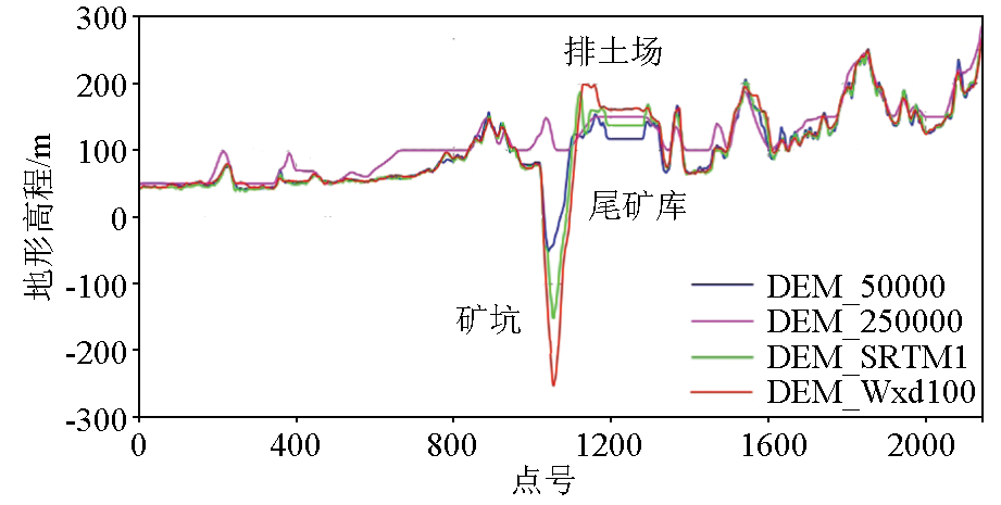
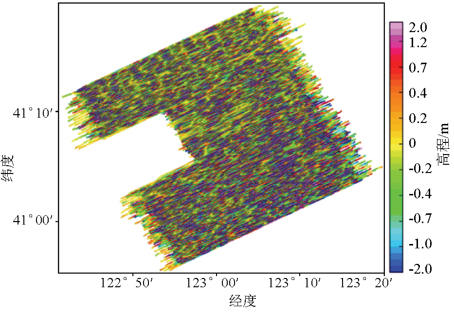
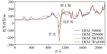
Comparison of DEM data collected on survey line L1710 with actual topography
|
|
Relationship between elevations
|

|
Actual surveyed terrain processing
a—initially obtain the actual surveyed terrain; b—actual surveyed terrain is levelled by the tie-line; c—actual surveyed terrain is levelled by microlevelling process; d—actual surveyed terrain after stripping off tall buildings
|

|
Extracted striping patterns
|

|
Extracted striping patterns by Naudy non-linear filter
|
|
Multi-source DEM data and the actual surveyed terrain after stitching SRTM1
a— 1:50000DEM; b—ASTER; c—SRTM1; d—AW3D30; e—SRTM3; f—actual surveyed terrain was stitched with SRTM1
|
| 序号 | 东向距/m | 北向距/m | 高度/m | 水平面/m | | 单点GNSS基站 | 1 | 0.699 | 0.995 | 2.315 | 1.216 | | 2 | 0.599 | 1.395 | 2.632 | 1.519 | | 3 | 0.565 | 1.390 | 2.366 | 1.500 | | 单点GNSS移动站 | 1 | 1.292 | 2.817 | 4.839 | 3.099 | | 2 | 1.071 | 2.241 | 3.268 | 2.484 | | 3 | 1.061 | 1.817 | 3.456 | 2.104 | | DGNSS移动站 | 1 | 0.010 | 0.007 | 0.006 | 0.012 | | 2 | 0.002 | 0.003 | 0.006 | 0.003 |
|
Static measurement standard deviation (STD)
|
|
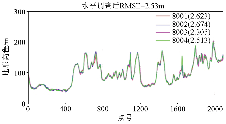
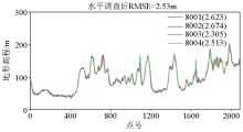
Internal accuracy statistics for repeated lines of elevation
|
| Wxd400 | Wxd100 | | 交叉点/个 | 609 | 4762 | | Min/m | -33.15 | -91.7 | | Max/m | 67.75 | 98.6 | | ME/m | 0.03 | 0.61 | | STD/m | 5.71 | 7.97 | | RMSE/m | 5.71 | 7.99 | | 总精度/m | 4.04 | 5.65 |
|
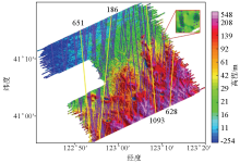
Statistics of survey network intersections of actual surveyed terrain
|
|
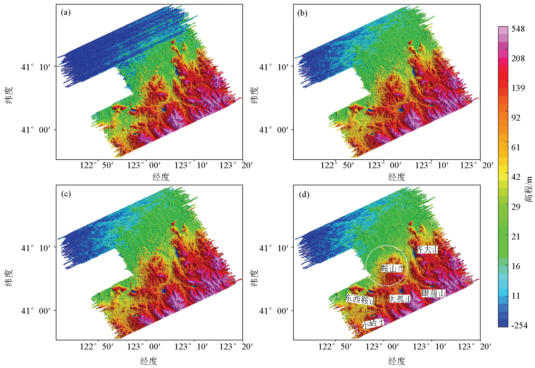
Map of ATL08 Laser data on the track in the experimental area
|
| | Wxd100 | Wxd400 | SRTM1 | AW3D30 | ASTER | 1:5万 | SRTM3 | | 调整前 | 点数/个 | 22162 | 20456 | 22745 | 22745 | 22745 | 22745 | 22745 | | Min/m | -116.87 | -111.62 | -125.98 | -123.49 | -125.37 | -142.56 | -123.73 | | Max/m | 149.7 | 149.24 | 230.99 | 228.2 | 226.68 | 284.35 | 229.89 | | ME/m | 1.54 | 2.42 | -0.75 | 2.1 | -4.2 | -0.46 | -0.31 | | STD/m | 9.79 | 12.33 | 14.88 | 11.24 | 14.59 | 17.86 | 14.92 | | RMSE/m | 9.91 | 12.56 | 14.90 | 11.43 | 15.18 | 17.87 | 14.93 | | 调整后 | 点数/个 | 19279 | 17720 | 19848 | 19848 | 19848 | 19848 | 19848 | | Min/m | -27.13 | -83.83 | -24.84 | -21.56 | -55.45 | -38.24 | -27.56 | | Max/m | 44.9 | 80.03 | 37.94 | 49.86 | 39.72 | 53.54 | 35.72 | | ME/m | 1.37 | 2.4 | -0.51 | 2.08 | -4.09 | -0.05 | -0.06 | | STD/m | 5.15 | 8.60 | 3.66 | 3.78 | 7.84 | 4.39 | 4.07 | | RMSE/m | 5.33 | 8.93 | 3.69 | 4.31 | 8.84 | 4.39 | 4.07 | | 采集时间 | 2013.10~2014.1 | 2013.12~2014.1 | 2000.2 | 2006~2011 | 1999~2008 | 不详 | 2000.2 |
|
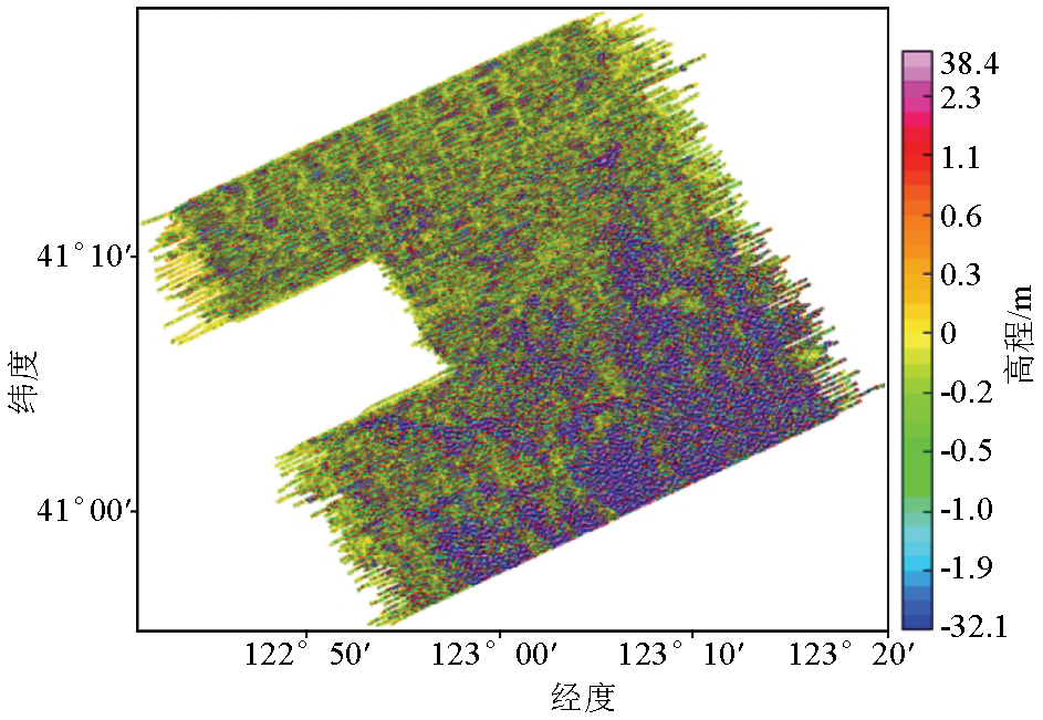
Multi-source DEM data statistics based on ICESat-2/ATL08
|
| | Wxd100 | Wxd400 | SRTM1 | AW3D30 | ASTER | 1:5万 | SRTM3 | 丘陵
及山区 | 点数/个 | 9894 | 9048 | 10220 | 10220 | 10220 | 10220 | 10220 | | Min/m | -27.13 | -83.83 | -24.84 | -21.56 | -55.45 | -38.24 | -27.56 | | Max/m | 44.9 | 80.03 | 37.94 | 49.86 | 38.37 | 53.54 | 35.72 | | ME/m | 2.48 | 3.62 | 0.3 | 2.61 | -6.71 | 1.33 | 0.8 | | STD/m | 6.71 | 11.74 | 4.75 | 4.83 | 8.35 | 5.69 | 5.40 | | RMSE/m | 7.15 | 12.28 | 4.76 | 5.49 | 10.71 | 5.84 | 5.46 | | 平原 | 点数/个 | 9313 | 8613 | 9547 | 9547 | 9547 | 9547 | 9547 | | Min/m | -10.45 | -15.84 | -14.84 | -9.24 | -25.31 | -15.87 | -14.98 | | Max/m | 35.01 | 49.27 | 16.46 | 46.54 | 39.72 | 20.52 | 17.1 | | ME/m | 0.21 | 1.13 | -1.35 | 1.54 | -1.21 | -1.49 | -0.96 | | STD/m | 2.14 | 2.23 | 1.52 | 2.07 | 6.08 | 1.20 | 1.29 | | RMSE/m | 2.15 | 2.50 | 2.03 | 2.57 | 6.20 | 1.91 | 1.60 |
|
Multi-source DEM data partition statistics based on ICESat-2/ATL08
|
|
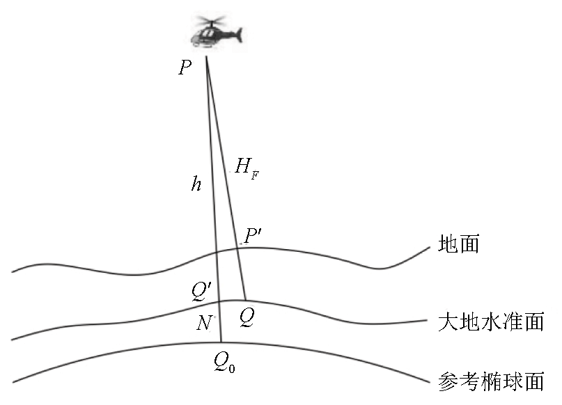
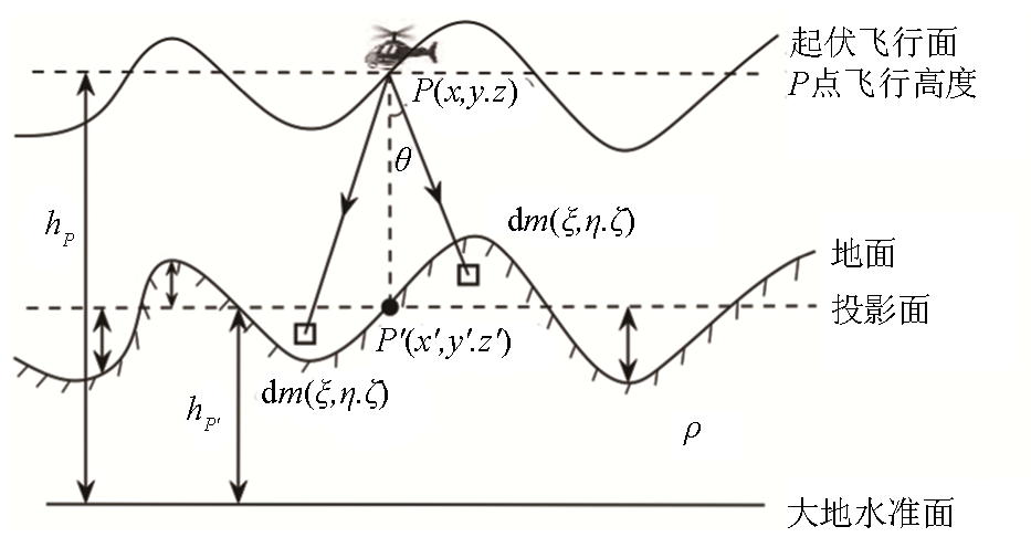
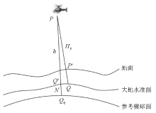
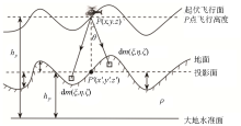
Schematic diagram of airborne gravity terrain correction
|
| 序号 | 高程地形 | 分辨率/m | 外符合总精度/
(10-5m· ) | 采集时间 | | A1 | 1:5万 | 25 | 1.159 | 早于2000 | | A2 | ASTER | 30 | 1.305 | 1999~2008 | | A3 | SRTM1 | 30 | 1.098 | 2000.2 | | A4 | AW3D30 | 30 | 1.063 | 2006~2011 | | A5 | SRTM3 | 90 | 1.097 | 2000.2 | | B1 | 1:5万_Wxd100 | 25 | 1.056 | 测区同步 | | B2 | ASTER_Wxd100 | 30 | 1.090 | 测区同步 | | B3 | SRTM1_Wxd100 | 30 | 1.054 | 测区同步 | | B4 | AW3D30_Wxd100 | 30 | 1.057 | 测区同步 | | B5 | SRTM3_Wxd100 | 90 | 1.056 | 测区同步 | | B6 | SRTM1_Wxd400 | 30/80 | 1.059 | 测区同步 |
|
The total accuracy of external coincidence for airborne Bouguer gravity by different DEM data
|
| B1~A1 | B2~A2 | B3~A3 | B4~A4 | B5~A5 | A5~A3 | B6~B3 | | Min/(10-5m· ) | -5.281 | -2.329 | -3.800 | -1.356 | -3.746 | -0.122 | -0.562 | | Max/(10-5m· ) | 4.887 | 2.646 | 3.693 | 1.194 | 3.728 | 0.019 | 0.524 | | ME/(10-5m· ) | -0.206 | -0.608 | -0.201 | 0.063 | -0.177 | -0.048 | -0.061 | | STD/(10-5m· ) | 0.589 | 0.581 | 0.420 | 0.242 | 0.412 | 0.007 | 0.126 |
|
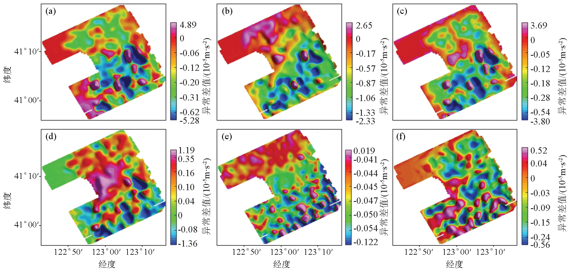
Statistics of Bouguer gravity difference between two DEM data
|
|
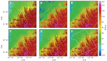
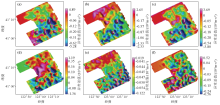
Difference map of Bouguer gravity anomaly difference between two DEM data
a—B1~A1; b—B2~A2; c— B3~A3;d—B4~A4;e—A5~A3; f— B6~B3
|
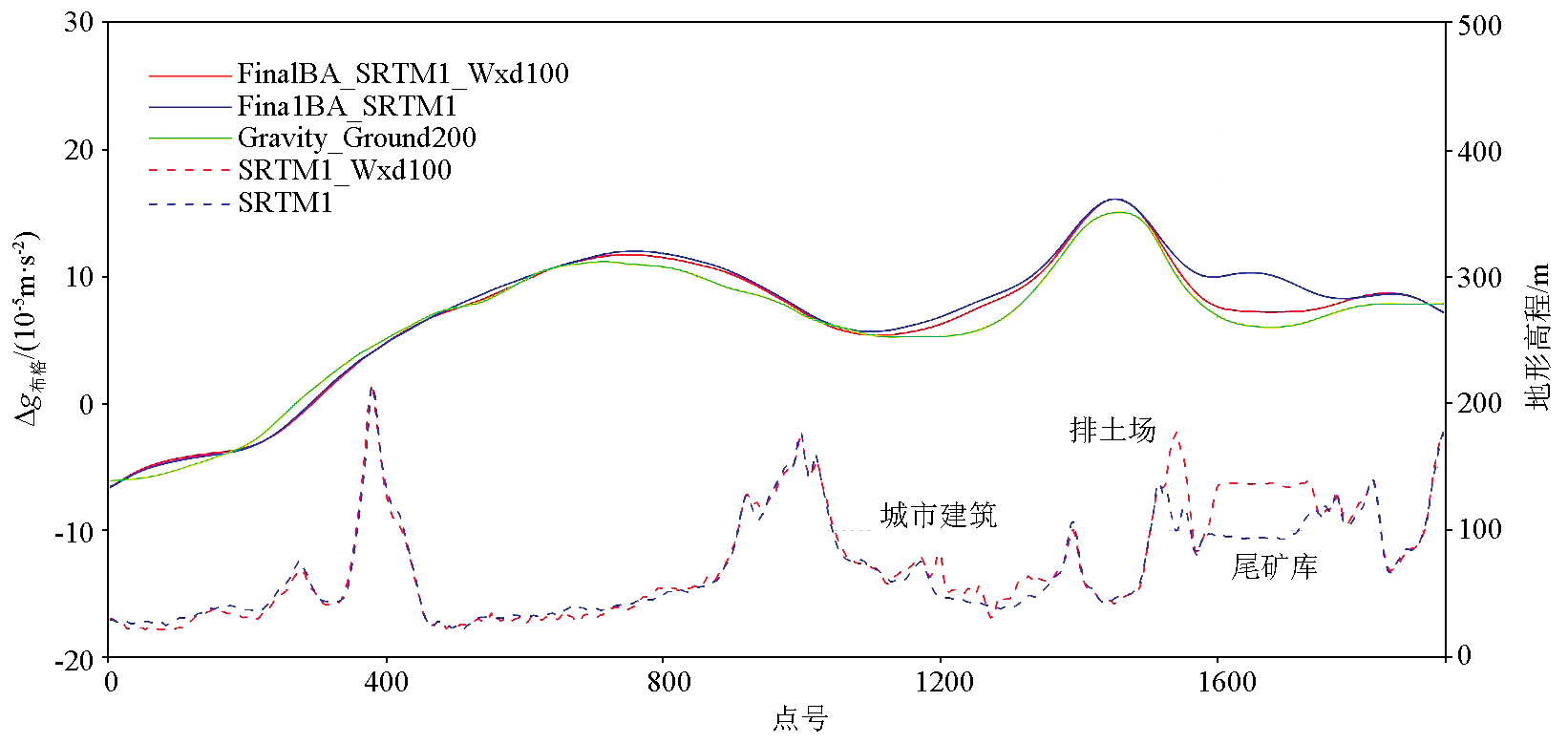
| 线号 | 1:5万 | SRTM1 | AW3D30 | 1:5万_Wxd100 | SRTM1_Wxd100 | AW3D30_Wxd100 | SRTM1_Wxd400 | 地形改变 | | L1990 | 0.801 | 0.669 | 0.645 | 0.649 | 0.646 | 0.650 | 0.680 | 排土场 | | L2070 | 1.077 | 0.863 | 0.811 | 0.785 | 0.786 | 0.786 | 0.800 | 矿坑、尾矿库 | | L2110 | 1.080 | 0.913 | 0.874 | 0.862 | 0.862 | 0.861 | 0.870 | 矿坑、尾矿库 | | L2230 | 1.126 | 0.915 | 0.677 | 0.644 | 0.645 | 0.645 | 0.672 | 尾矿库、城市建筑 | | L2270 | 1.351 | 1.104 | 0.783 | 0.672 | 0.673 | 0.677 | 0.720 | 尾矿库、排土场 | | L2550 | 1.870 | 1.592 | 1.141 | 1.044 | 1.041 | 1.047 | 0.905 | 矿坑、排土场 | | L2590 | 1.849 | 1.565 | 1.059 | 0.947 | 0.945 | 0.951 | 0.933 | 矿坑、排土场 | | T9130 | 1.561 | 1.361 | 0.974 | 1.064 | 1.036 | 1.056 | 1.084 | 两处矿坑 | | T9140 | 1.699 | 1.308 | 0.747 | 0.672 | 0.672 | 0.676 | 0.665 | 排土场、尾矿库 |
|
The external coincidence accuracy of airborne Bouguer gravity under different DEM data for typical lines(10-5m· )
|
|
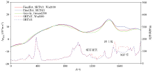
Comparison of airborne Bouguer gravity anomaly on L2270
|
| [1] |
熊盛青, 周锡华, 郭志宏, 等. 航空重力勘探理论方法及应用[M]. 北京: 地质出版社, 2010.
|
| [1] |
Xiong S Q, Zhou X H, Guo Z H, et al. Theory,method and application of the airborne gravity processing[M]. Beijing: Geological Publishing House, 2010.
|
| [2] |
William R G. An historical review of airborne gravity[J]. The Leading Edge, 1998(l):113-116.
|
| [3] |
吴美平, 张开东. 基于捷联惯性导航系统/差分全球定位系统的航空重力测量技术[J]. 科技导报, 2007, 25(17):74-80.
|
| [3] |
Wu M P, Zhang K D. Technology of airborne gravimetry based on SINS/DGPS[J]. Science & Technology Review, 2007, 25(17):74-80.
|
| [4] |
Verdun J, Bayer R, Klingelé E E, et al. Airborne gravity measurements over mountainous areas by using a Lacoste & Romberg air-sea gravity meter[J]. Geophysics, 2002, 67(3):807-816.

|
| [5] |
Bell R, Coakley B, Stemp R. Airborne gravimetry from a small twin engine aircraft over the long island sound[J]. Geophysics, 1991, 56(9):1486-1493.
|
| [6] |
Schwarz K P, Colombo O, Hein G, et al. Requirements for airborne vector gravimetry[C]// From Mars to Greenland: Charting Gravity with Space and Airborne Instruments, 1992.
|
| [7] |
Studinger M, Bell R, Frearson N. Comparison of AIRGrav and GT-1A airborne gravimeters for research applications[J]. Geophysics, 2008, 73(6):151-161.
|
| [8] |
Olson D. GT-1A and GT-2A airborne gravimeters:Improvements in design,operation,and processing from 2003 to 2010[C]// Aiborne Gravity 2010-Abstracts from the ASEG-PESA Airborne Gravity 2010 Workshop, 2010.
|
| [9] |
Rodríguez E, Morris C S, Belz J E. A global assessment of the SRTM performance[J]. Photogrammetric Engineering and Remote Sensing, 2006, 72(3):249-260.
|
| [10] |
Tadono T, Ishida H, Oda F, et al. Precise global DEM generation by ALOS PRISM[J]. ISPRS Annals of the Photogrammetry,Remote Sensing and Spatial Information Sciences, 2014, 2(4):71-76.
|
| [11] |
程鹏飞, 文汉江, 成英燕, 等. 2000国家大地坐标系椭球参数与GRS80和WGS84的比较[J]. 测绘学报, 2009, 38(3):189-194.
|
| [11] |
Cheng P F, Wen H J, Cheng Y Y, et al. Parameters of the CGCS 2000 ellipsoid and comparisons with GRS 80 and WGS 84[J]. Acta Geodaetica et Cartograohica Sinica, 2009, 38(3):189-194.
|
| [12] |
焦文海, 魏子卿, 马欣, 等. 1985国家高程基准相对于大地水准面的垂直偏差[J]. 测绘学报, 2002, 31(3):196-200.
|
| [12] |
Jiao W H, Wei Z Q, Ma X, et al. The orgin vertical shift of national height datum 1985 with respect to the geoidal surface[J]. Acta Geodaetica et Cartograohica Sinica, 2002, 31(3):196-200.
|
| [13] |
郭海荣, 焦文海, 杨元喜. 1985国家高程基准与全球似大地水准面之间的系统差及其分布规律[J]. 测绘学报, 2004, 33(2):100-104.
|
| [13] |
Guo H R, Jiao W H, Yang Y X. The systematic difference and its distribution between the 1985 national height datum and the global quasigeoid[J]. Acta Geodaetica et Cartograohica Sinica, 2004, 33(2):100-104.
|
| [14] |
赫林, 李建成, 褚永海. 1985国家高程基准与全球高程基准之间的垂直偏差[J]. 测绘学报, 2016, 45(7):768-774.
|
| [14] |
He L, Li J C, Chu Y H. The vertical shift between 1985 national height datum and global vertica datum[J]. Acta Geodaetica et Cartograohica Sinica, 2016, 45(7):768-774.
|
| [15] |
李建成, 褚永海, 徐新禹. 区域与全球高程基准差异的确定[J]. 测绘学报, 2017, 46(10):64-75.
|
| [15] |
Li J C, Chu Y H, Xu X Y. Determination of vertical datum offset between the regional and the global height datum[J]. Acta Geodaetica et Cartograohica Sinica, 2017, 46(10):64-75.
|
| [16] |
孙中苗, 李迎春. 航空重力测量中激光测高数据的处理与应用[J]. 测绘通报, 2003(11):11-13.
|
| [16] |
Sun Z M, Li Y C. Laser altimetric data for airborne gravimetry:processing and application[J]. Bulletion of Surveying and Mapping, 2003(11):11-13.
|
| [17] |
Foster M R, Jines W R, Van d W K. Statistical estimation of systematic errors at intersections of lines of aeromagnetic survey data[J]. Journal of Geophysical Research Atmospheres, 1970, 75(8):1507-1511.
|
| [18] |
Yarger H L, Robertson R R, Wentlandet R L. Diurnal drift removal from aeromagnetic data using least squares[J]. Geophysics, 1978, 43(6):1148-1156.
|
| [19] |
Green A A. A comparison of adjustment procedures for leveling aeromagnetic survey data[J]. Geophysics, 1983, 48(6):745-753.
|
| [20] |
Minty B R S. Simple Micro-leveling for aeromagnetic data[J]. Exploration Geophysics, 1991, 22(4):591-592
|
| [21] |
Ferraccioli F, Gambetta M, Bozzo E. Microlevelling procedures applied to regional aeromagnetic data:An example from the transantarctic mountains (Antarctica)[J]. Geophysical Prospecting, 1998, 46(2):177-196.
|
| [22] |
Naudy H, Dreyer H. Essai de filtrage non-iineaire applique aux profils aeromagnetiques[J]. Geophysical Prospectiong, 1968(2):171-178.
|
| [23] |
骆遥, 王平, 段树岭, 等. 航磁垂直梯度调整ΔT水平方法研究[J]. 地球物理学报, 2012, 55(11):3854-3861.
|
| [23] |
Luo Y, Wang P, Duan S L, et al. Leveling total field aeromagnetic data with measured vertical gradient[J]. Chinese Journal of Geophysics, 2012, 55(11):3854-3861.
|
| [24] |
于长春, 熊盛青, 董继国. 数字地形模型数据获取方法及精度分析[J]. 物探与化探, 2001, 25(3):198-202.
|
| [24] |
Yu C C, Xiong S Q, Dong J G. The technique for acquisition of DTM data and an analysis of its precision[J]. Geophysical and Geochemical Exploration, 2001, 25(3):198-202.
|
| [25] |
郭志宏, 熊盛青, 周坚鑫, 等. 航空重力重复线测试数据质量评价方法研究[J]. 地球物理学报, 2008, 51(5):1538-1543.
|
| [25] |
Guo Z H, Xiong S Q, Zhou J X, et al. The research on quality evaluation method of test repeat lines in airborne gravity survey[J]. Chinese Journal of Geophysics, 2008, 51(5):1538-1543.
|
| [26] |
屈进红, 姜作喜, 周锡华, 等. 航空重力测网交叉点的非遍历逼近方法[J]. 测绘学报, 2022, 51(1):71-79.
|
| [26] |
Qu J H, Jiang Z X, Zhou X H, et al. Non-ergodic approximation method for intersections of airborne gravity survey network[J]. Acta Geodaetica et Cartograohica Sinica, 2022, 51(1):71-79.
|
| [27] |
中华人民共和国自然资源部. DZ/T 0381—2021. 航空重力测量技术规范[S]. 北京: 地质出版社, 2021.
|
| [27] |
Ministry of Natural Resources of the People's Republic of China. DZ/T 0381—2021. Specification for airborne gravity survey[S]. Beijing: Geological Publishing House, 2021.
|
| [28] |
Markus T, Neumann T A, Martino A J, et al. The ice,cloud and land elevation satellite-2 (ICESat-2):Science requirements,concept and implementation[J]. Remote Sensing of Environment, 2017, 190:270-273.
|
| [29] |
夏少波, 王成, 习晓环, 等. ICESat-2机载试验点云滤波及植被高度反演[J]. 遥感学报, 2014, 18(6):1199-1207.
|
| [29] |
Xia S B, Wang C, Xi X H, et al. Point cloud filtering and tree height estimation using airborne experiment data of ICESat-2[J]. Journal of Remote Sensing, 2014, 18(6):1199-1207.
|
| [30] |
王密, 韦钰, 杨博, 等. ICESat-2/ATLAS全球高程控制点提取与分析[J]. 武汉大学学报:信息科学版, 2021, 46(2):184-192.
|
| [30] |
Wang M, Wei Y, Yang B, et al. Extraction and analysis of global elevation control points from ICESat-2/ATLAS data[J]. Geomatics and Information Science of Wuhan University, 2021, 46(2):184-192.
|
| [31] |
中华人民共和国国土资源部. DZ/T 0004—2015.重力调查技术规范(1:50000)[S]. 北京: 地质出版社, 2015.
|
| [31] |
Ministry of Land and Resources of the People’s Republic of China. DZ/T 0004—2015.The technical specification for gravity survey(1:50000)[S]. Beijing: Geological Publishing House, 2015.
|
| [32] |
孙中苗. 航空重力测量理论、方法及应用研究[D]. 郑州: 中国人民解放军信息工程大学, 2004.
|
| [32] |
Sun Z M. Theory,methods and application of airborne gravimetry[D]. Zhengzhou: Information Engineering University, 2004.
|
| [1] |
ZHANG Zhi, XU Hong-Miao, QIAN Jia-Zhong, XIE Jie, CHEN Hao-Long, ZHU Zi-Xang. An application study of the comprehensive geophysical prospecting method in the exploration of mineral water: A case study of the Langqiao area, Jing County[J]. Geophysical and Geochemical Exploration, 2023, 47(3): 690-699. |
| [2] |
Qi Zhao-Hua. Application of the wide-field electromagnetic method in hydrogeological exploration under the extremely-thick low-resistivity layer: A case study of a coal mine in the Huainan area, Anhui Province[J]. Geophysical and Geochemical Exploration, 2023, 47(3): 700-706. |
|
|
|
|