|
|
|
| A study of the measurement method for gravity and magnetic slow fluctuation of helicopter in the medium-low mountainous area |
GENG Sheng-Bo1( ), YAN Hong-Yu1, AN Zhan-Feng1( ), YAN Hong-Yu1, AN Zhan-Feng1( ), GUAN Hai-Jing2, WANG Zhi-Bo1, JIN Jiu-Qiang1, XUN Ming1, WANG Xin1, LI Bing1, GUO Qi1 ), GUAN Hai-Jing2, WANG Zhi-Bo1, JIN Jiu-Qiang1, XUN Ming1, WANG Xin1, LI Bing1, GUO Qi1 |
1. China Aero Geophysical Survey and Remote Sensing Center for Natural Resources,Beijing 100083
2. Postal Savings Bank of China,Beijing 100166 |
|
|
|
|
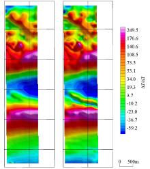
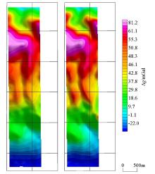
Abstract By the modification of the AS350-B3 helicopter, the airborne gravity and magnetic measurement system suitable for the medium-low mountainous area is integrated. The 3D measurement network with the maximum slope of 3° was designed, and the gravity and magnetic measurement method by helicopter was first applied in the medium-low mountainous area. The measurement results show that the slow rise and fall measurement method can keep the aircraft track well in the three-dimensional space, and can effectively control the height difference between the intersection points of the survey line and the cross line, so that the survey line and the cut line form a network, which plays a beneficial role in the magnetic field leveling. The comparison of the results of the horizontal flight measurement and the slow rise and fall measurement shows that the slow rise and fall measurement method can not only take into account both gravity and magnetic measurement methods, but also exert more obvious mapping effect than the horizontal flight anomaly characteristics.
|
|
Received: 23 February 2021
Published: 15 December 2021
|
|
|
|
Corresponding Authors:
AN Zhan-Feng
E-mail: gengshengboy@163.com;anzhanfeng@ags.gov.cn
|
|
|
|

|
Geological map of survey area
|

| 机型 | 实用升限/m | 爬升率/(m·s-1) | 跑道要求/m | 航程/km | 平均速度/(km·h-1) | | AS350-B3 | 7800 | 10 | 无 | 665 | 230 | | AS350-B2 | 4800 | 8.9 | 无 | 670 | 226 | | 运-12 | 7000 | 9.2 | 700 | 1400 | 250 | | 运-8 | 10400 | 10.0 | 3000 | 5620 | 550 | | 国王350 | 10058 | 12.2 | 2313 | 4537 | 502 |
|
Parameters of the main airborne geophysical flying-platforms
|

|
Variation of magnetic interference field
|

设备
名称 | 机舱内设备质量/
kg | 外挂设备质量/
kg | 设备质量合计/
kg | | 航磁系统 | 70 | 45 | 115 | | 航重系统 | 150 | 无 | 150 |
|
The weight of the aero gravity and magnetic measurement system
|

|
Aero gravity and magnetic measuring system installation diagram
|

|
Aero gravity and magnetic measurement system
|

| 测试项目 | 航磁系统 | 航重系统 | | 静态四阶差分/pT | 2D导航定位精度/m | | 静态精度/mGal | 差分GPS精度测试/cm | | | 规范要求 | 10 | ±10 | RMS≤ 0.4 | <10 | | 实测结果 | 0.696 | 1.048 | 0.152 | 1.69 |
|
Static Testing result of aero gravity and magnetic measurement system
|

| 测试项目 | 航磁系统补偿效果/
pT | 航重系统内符合精度/
mGal | | 规范要求 | 0.08 | 0.8 | | 实测结果 | 0.079 | 0.543 |
|
Dynamic testing result aero gravity and magnetic measurement system
|

|
2 D plane survey grid navigation diagram
|

|
3 D plane survey grid navigation diagram
|

|
3D plane survey grid diagram(“—.—” is DEM data)
|

|
Design survey line diagram
|

|
Terrain(up)and flight path(down)
|

|
Height difference statistics of flight path and design survey line
|

|
The height difference statistics between the intersection points of the survey line and the cross line
|

|
Horizontal flight aero magnetic ΔT shadow diagram(left) and slow rise and fall flight aero magnetic ΔT shadow diagram (rigth)
|

|
Horizontal flight aero space gravity shadow diagram (left) and slow rise and fall flight aero space gravity shadow diagram (rigth)
|
| [1] |
熊盛青, 于长春, 王卫平, 等. 直升机大比例尺航空物探在深部找矿中的应用前景[J]. 地球科学进展, 2008, 23(3):270-275.
|
| [1] |
Xiong S Q, Yu C C, Wang W P, et al. Large scale areo geophysical survey with heicopter and its application to deep ore prospecting[J]. Advance in Earth Science, 2008, 23(3):270-275.
|
| [2] |
周坚鑫, 刘浩军, 王守坦, 等. 国外航空重力测量在地学中的应用[J]. 物探与化探, 2004, 28(2):119-122.
|
| [2] |
Zhou J X, Liu H J, Wang S T, et al. The applicantion of airborne gravity survey to earth science in foreing countries[J]. Geophysical and Geochemical Exploration, 2004, 28(2):119-122.
|
| [3] |
夏哲仁, 孙中苗. 航空重力测量技术及其应用[J]. 测绘科学, 2006, 31(6):43-46.
|
| [3] |
Xia Z R, Sun Z M. The technology and applicantion of airborne gravity survey[J]. Science of Surveying and Mapping, 2006, 31(6):43-46.
|
| [4] |
王鑫, 周锡华, 耿圣博, 等. 鞍山—本溪地区高分辨率航空物探测量应用示范测量成果报告[R]. 中国自然资源航空物探遥感中心, 2014.
|
| [4] |
Wang X, Zhou X H, Geng S B, et al. Results report of Anshan-Benxi demonstration measurement application of high resolution aero geophysical measurement [R]. China Aero Geophysical Survey and Remote Sensing Center for Natural Resources, 2014.
|
| [5] |
邓茂盛, 耿圣博. 云南腾冲—云县地区航磁调查测量成果报告[R]. 中国自然资源航空物探遥感中心, 2016.
|
| [5] |
Deng M S, Geng S B. Results report of YunnanTengchong-Yunxian aeromagnetic surveys measurement[R]. China Aero Geophysical Survey and Remote Sensing Center for Natural Resources, 2016.
|
| [6] |
于长春, 熊盛青, 刘士毅, 等. 直升机航磁方法在大冶铁矿区深部找矿中的见矿实例[J]. 物探与化探, 2010, 34(4):435-439.
|
| [6] |
Yu C C, Xiong S Q, Liu S Y, et al. By helicopter aeromagnetic survey in the daye iron mine[J]. Geophysical and Geochemical Exploration, 2010, 34(4):435-439.
|
| [7] |
许苏鹏, 姬泰脉, 纪福山, 等. AS350-B3型直升机硬架航空磁测系统在青藏高原上的应用[J]. 物探与化探, 2013, 37(4):640-644.
|
| [7] |
Xu S P, Ji T M, Ji F S, et al. The application of aero geomagnetic survey system by AS350-B3 helicopter in the tibetan plateau[J]. Geophysical and Geochemical Exploration, 2013, 37(4):640-644.
|
| [8] |
崔志强, 胥值礼, 孟庆敏. 国内主要航空物探飞行平台特点及发展[J]. 物探与化探, 2014, 38(6):1107-1113.
|
| [8] |
Cui Z Q, Xu Z L, Meng Q M. The features of the main airborne geophysical flying-platforms in China and the development tread[J]. Geophysical and Geochemical Exploration, 2014, 38(6):1107-1113.
|
| [9] |
熊盛青, 余长春. 中低山区高精度航磁方法技术[M]. 北京: 地质出版社, 2009.
|
| [9] |
Xiong S Q, Yu C C. High-precision areo-magnatic survey in medium-height mountainous areas [M]. Beijing: Geological Publishing House, 2009.
|
| [10] |
李承东, 赵利刚, 许雅雯, 等. 北秦岭宽坪岩群变质沉积岩年代学及地质意义[J]. 中国地质, 2018, 45(5):992-1010.
|
| [10] |
Li C D, Zhao L G, Xu Y W, et al. Chronology of metasedimentary rocks from Kuanping Group complex in North Qinling Belt and its geological significance[J]. Geology in China, 2018, 45(5):992-1010.
|
| [11] |
董云鹏, 张国伟. 北秦岭构造属性与元古代构造演化[J]. 地球学报, 2003, 24(1):3-10.
|
| [11] |
Dong Y P, Zhang G W. Proterozoic tectonics and evolutionary history of the north qinling terrane[J]. Acta Geoscientia Sinica, 2003, 24(1):3-10.
|
| [12] |
黄萱, 孙宝山, 潘均, 等. 东秦岭华北地台区岩浆活动的时代及地壳增生和再改造[J]. 岩石学报, 1995, 11(2):171-178.
|
| [12] |
Huang X, Sun B S, Pan J, et al. The ages of igneous rocks from Eastem Qinling of north China platform and the crustal growth and reworking of the terrane[J]. Acta Petrologica Sinica, 1995, 11(2):171-178.
|
| [13] |
DZ/T0142—2010,航空磁测技术规范[S]. 北京: 中国标准出版社, 2010.
|
| [13] |
D/T0142—2010, Criterion of aeromagnetic survey [M]. Beijing: Standards Press of China, 2010.
|
| [14] |
管志宁. 地磁场与磁力勘探[M]. 北京: 地质出版社, 2005.
|
| [14] |
Guan Z N. Geomagnetic field and magnetic exploration [M]. Beijing: Geological Publishing House, 2005.
|
| [15] |
曾华霖. 重力场与重力勘探[M]. 北京: 地质出版社, 2005.
|
| [15] |
Zeng H L. Gravity field and gravity exploration [M]. Beijing: Geological Publishing House, 2005.
|
| [16] |
Joint-Stock Company. Airborne gravimeter model GT-1A Operation Manual Constants Logbook[M]. Moscow, 2008.
|
| [17] |
李冰, 王志博, 乔杨, 等. 航空重力起伏飞行中飞机姿态对测量数据影响分析[J]. 物探与化探, 2014, 37(5):1024-1028.
|
| [17] |
Li B, Wang Z B, Qiao Y, et al. The impact of aircraft attitude on the measurement of airborne gravity survey under drap flying[J]. Geophysical and Geochemical Exploration, 2014, 38(5):1024-1028.
|
| [18] |
尹伟言, 陈真, 聂晶, 等. 影响航空重力测量质量的若干因素分析[J]. 测绘工程, 2018, 27(4):21-28.
|
| [18] |
Yin W Y, Chen Z, Nie J, et al. Analysis on some factors of influencing airborne gravity survey quality[J]. Engineering of Surveying and Mapping, 2018, 27(4):21-28.
|
| [1] |
ZHAO Bao-Feng, WANG Qi-Nian, GUO Xin, GUAN Da-Wei, CHEN Tong-Gang, FANG Wen. Gravity survey and audio magnetotellurics-based insights into the deep structures and geothermal resource potential of the Rucheng Basin[J]. Geophysical and Geochemical Exploration, 2023, 47(5): 1147-1156. |
| [2] |
HE Sheng, WANG Wan-Ping, DONG Gao-Feng, NAN Xiu-Jia, WEI Feng-Feng, BAI Yong-Yong. Application of the opposing-coils transient electromagnetic method in urban geological surveys[J]. Geophysical and Geochemical Exploration, 2023, 47(5): 1379-1386. |
|
|
|
|

