|
|
|
| A case study of water prospecting by electrical method in clastic rock area of Guangxi |
| Guo-Min HUANG, Shi-Ping LI, Yi TAO, Cheng-Feng YANG, Qing-Shi ZENG |
| Guangxi Geological Survey Institute, Nanning 530023,China |
|
|
|
|
Abstract Statistics show that, during the 12th Five-Year Plan period,1747 wells were drilled for drought-resistant water prospecting in Guangxi. The electric method had a 75% success rate in finding water in karst area and 10% in clastic rock area, showing remarkable difference. The difference in lithology and hydrogeological conditions between the clastic rock and the karst rock is the main internal cause of the great difference in the effects of the electric method. The stratigraphic lithology of the clastic rock area is mainly mud rock and conglomerate rock, among which, the siltstone and fine sandstone in the mud rock and sand rock have poor water content conditions. This kind of rock is a low-reisitivity rock ,which is an interference layer of electric water exploration rather than a target stratum. Coarse sandstone and conglomerate in sand rocks belong to hard and brittle rocks, which are likely to form fissures and water. This kind of rock belongs to high resistivity stratum,which is the main target bed for electric water exploration. In the clastic rock area, the upper part of the layer with significant changes in the lithofacies is developed by fracture propagation and is rich in groundwater. Based on the case analysis, this paper summarizes the experience of electrical water prospecting in clastic rock mountains, and provides a reference for the future electrical water prospecting in clastic rock areas.
|
|
Received: 27 March 2017
Published: 20 February 2019
|
|
|
|
Corresponding Authors:
Shi-Ping LI
|
|
|
|

| 地层 | 岩性或
地质体 | ρs/(Ω·m) | 数据来源 | | 范围 | 平均值 | | 第四系 | 黏土 | 10~100 | 60 | 实测 | | 碎屑岩 | 泥岩 | 10~20 | 15 | 测井统计 | | 粉砂岩、细砂岩 | 10~100 | 50 | | 中砂岩 | 100~250 | 120 | | 粗砂岩 | 100~450 | 280 | | 砾岩 | 100~410 | 250 | | 碎屑岩 | 充水充泥裂隙 | 80~200 | 60~120 | 测井统计 |
|
Rock electrical parameter statistics
|
|
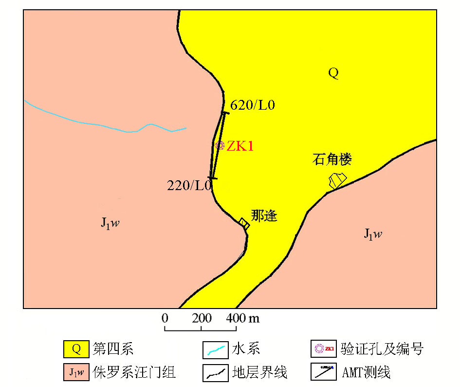
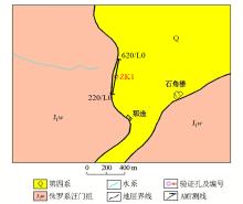
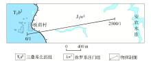
The geological map of Napeng village
|
|
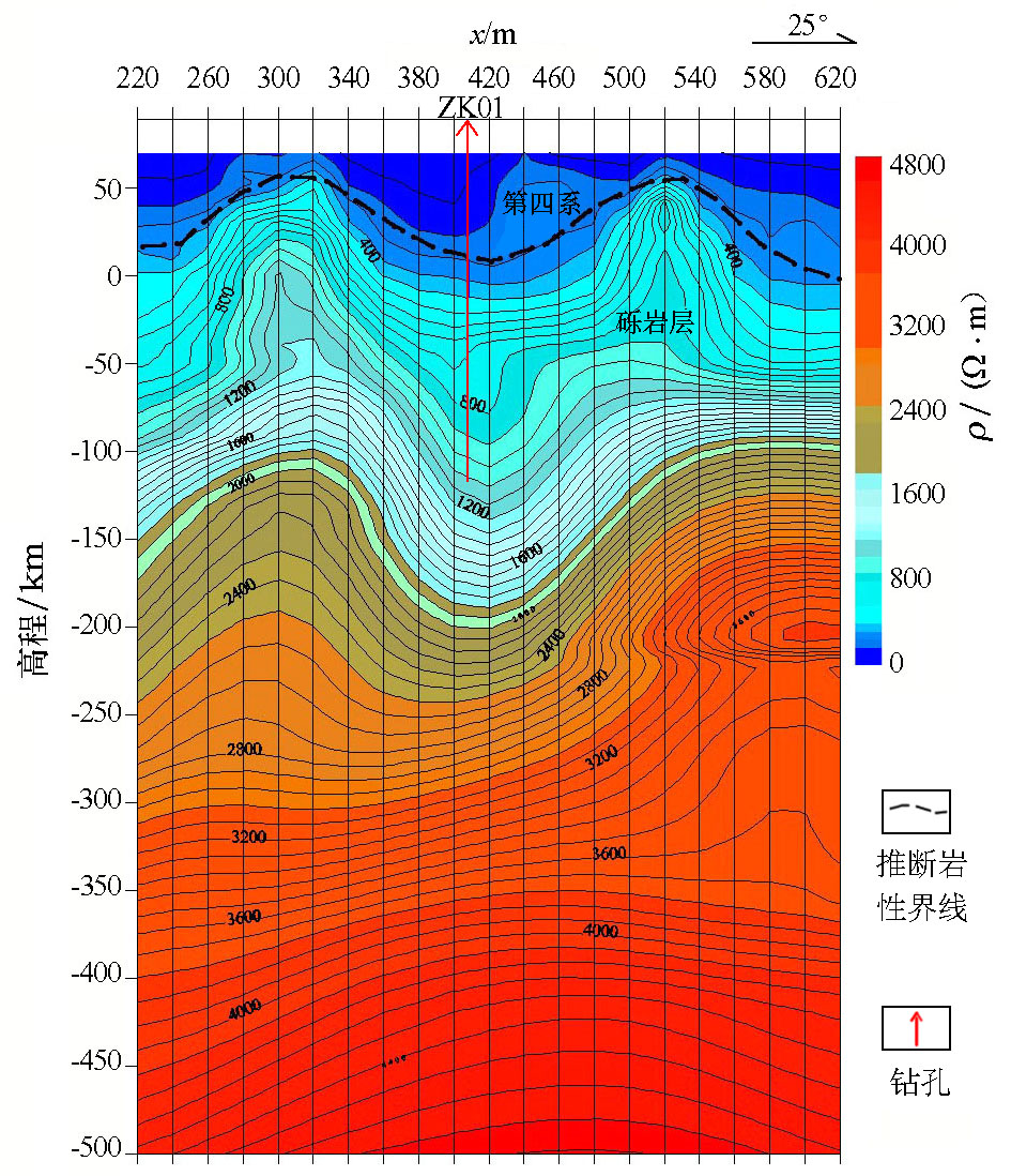
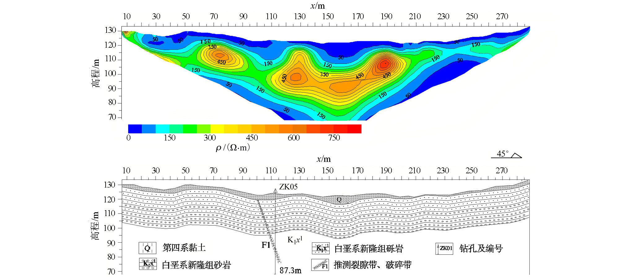
The Measurement results map of the EH-4 method in Napeng village
|

|
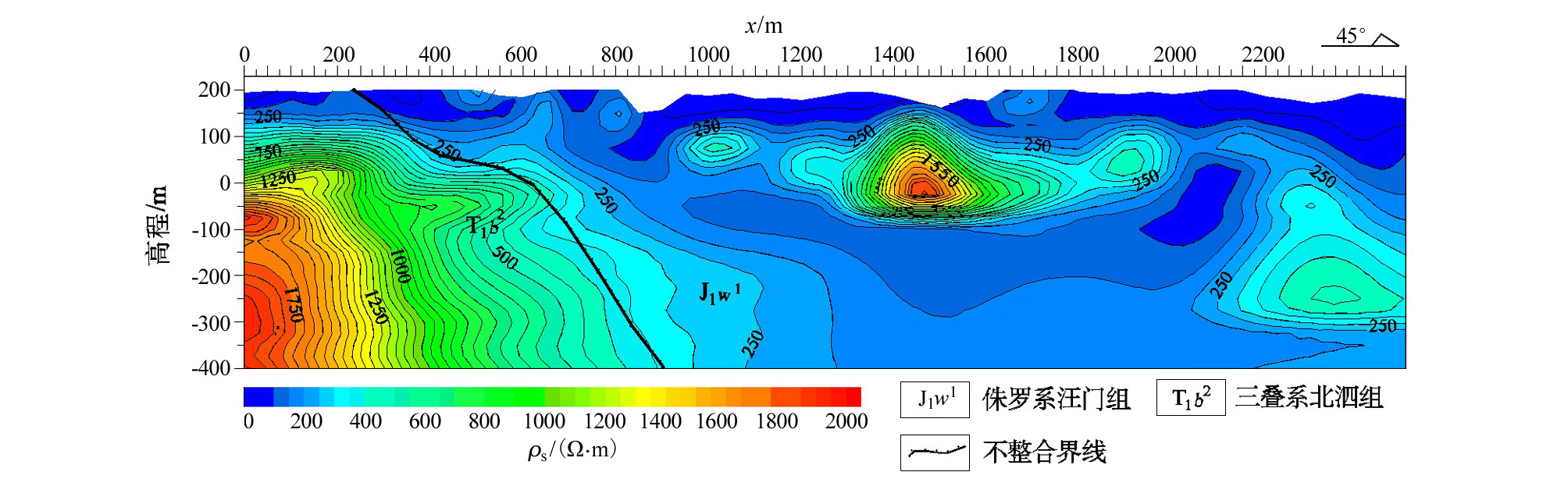
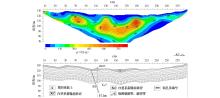
High density resistivity twodimensional inversion profile of L5 in Tanliang village
|
|
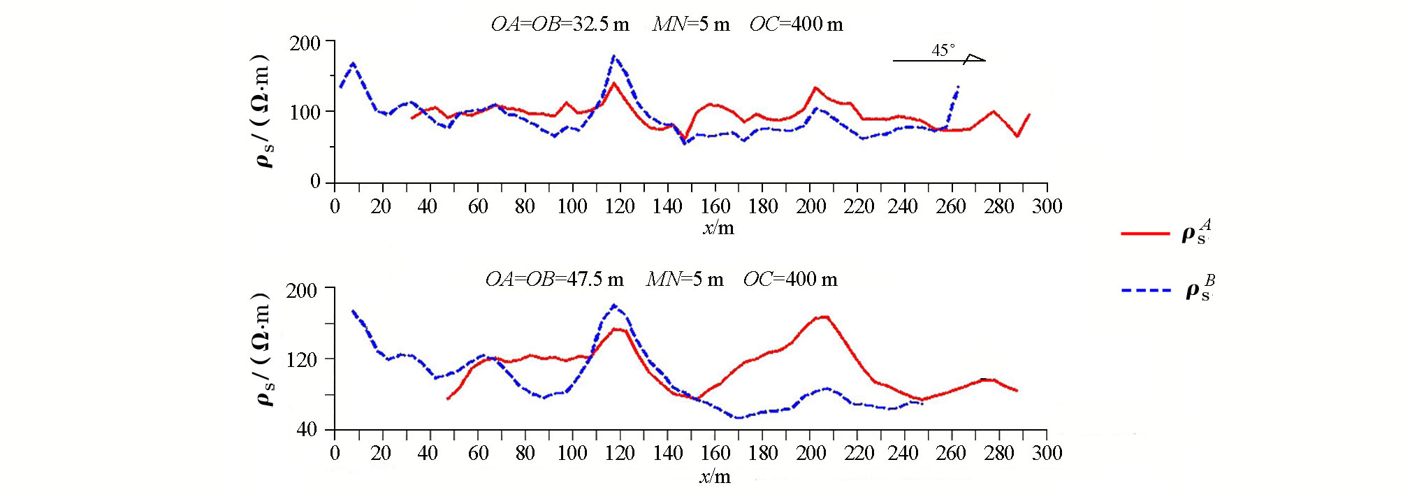
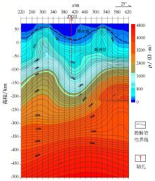
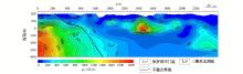
The measurement results map of 1-line apparent resistivity in Puwan village
|
|
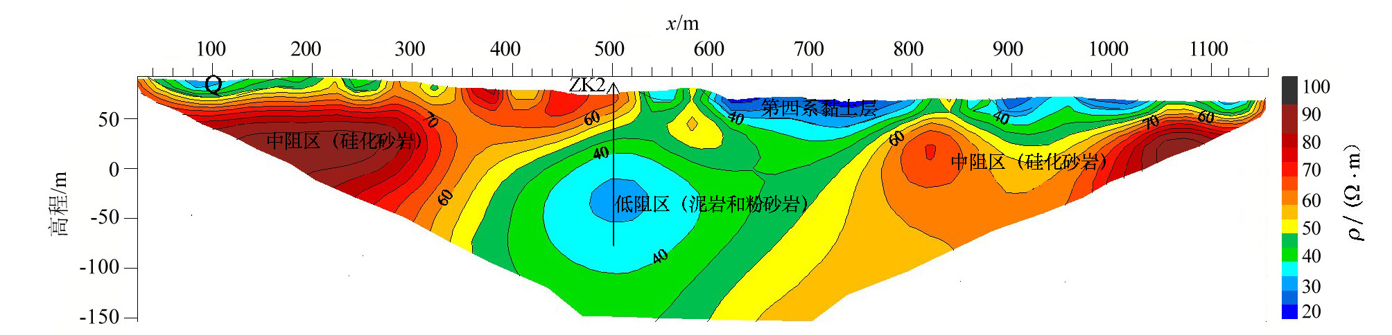
High density resistivity twodimensional inversion profile (top) and geological interpretation map (bottom) of 1-line in Puwan village
|
|
The geological map of Banhe village
|
|
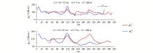
The measurement results map of the EH-4(AMT) method in Banhe village
|
| [1] |
李亚美, 陈国勋 . 地质学基础[M]. 北京: 地质出版社, 1994.
|
| [1] |
Li Y M, Chen G X. Geological basis[M]. Beijing: Geological publishing house, 1994.
|
| [2] |
李晓峰, 胡俭春, 曲林生 . 试论碎屑岩地区的找水方法[J]. 吉林地质, 2009,28(4):102-115.

|
| [2] |
Li X F, Hu J C, Qu L S . Try to talk about clastic rocks flew to find water method[J]. Jilin Geology, 2009,28(4):102-115.
|
| [3] |
王松涛, 郭粤莲, 蒋安云 . 瞬变电磁法在碎屑岩中找水的应用[J]. 中国煤炭地质, 2007,19(2):123-125.
|
| [3] |
Wang S T, Guo Y L , Jiang A Y.Application of water research tramsiemt electromagnetic method clastic rock areas[J].Coal geology of China, 2007, 19(2):123-125 .
|
| [4] |
王士鹏 . 高密度电法在水文地质和工程地质应用[J].水文地质工程地质,2000(1):52-53.
|
| [4] |
Wang S P . Application of high density electrical method in hydrogeology and engineering geology[J].Hydrogeology and engineering Geology, 2000(1):52-53.
|
| [5] |
杨发杰, 巨妙兰, 刘全德 . 高密度电阻率探测方法及其应用[J]. 矿产与地质, 2004,18(4):356-360.
|
| [5] |
Yang F J, Ju M L, Liu Q D . Method and application of high density resistivity detection[J]. Mineral resources and Geology, 2004,18(4):356-360.
|
| [6] |
王永生, 张玉池 . 高密度电法在灰岩地区找水中的应用[J]. 矿产与地质, 2018,32(2):345-351.
|
| [6] |
Wang Y S, Zhang Y C . Application of high densty resistivity method in water exploration in limestone area[J]. Mineral resources and Geology, 2018,32(2):345-351.
|
| [7] |
曹福祥, 尹秉喜, 朱庆俊 . 电导率成像系统在西部地下水勘查中的应用[J]. 物探与化探, 2005,29(4):323-325.
|
| [7] |
Cao F X, Yin B X, Zhu Q J . The application of the conductivity imaging system to groundwater investigation in western china[J]. Geophysical and Geochemical Exploration, 2005,29(4):323-325.
|
| [8] |
黄国民, 李世平, 陶毅 , 等. 广西“十二五”农村饮水安全工程找水打井物探成果报告[R]. 广西壮族自治区地质调查院, 2015.
|
| [8] |
Huang G M, Li S P, Tao Y , et al. Guangxi 12th five-year plan rural drinking water safety project to find water drilling geophysical exploration results report[R]. The Guangxi Zhuang Autonomous Region Geological Survey Institute, 2015.
|
| [9] |
黄春阳, 黄国民, 陶毅 , 等. 左江流域天西幅1∶5万水文地质环境地质调查物探成果报告[R]. 广西壮族自治区地质调查院, 2017.
|
| [9] |
Huang C Y, Huang G M, Tao Y , et al. Hydrogelogical and environmental geological survey and geophysical exploration results report of 1∶50000 tianxi section of zuojiang river basin[R]. The Guangxi Zhuang Autonomous Region Geological Survey Institute, 2017.
|
| [1] |
DING Wei-Zhong, SUN Fu-Wen, LI Jian-Hua, ZHENG Cai-Jun, LIN Pin-Rong, QI Fang-Shuai. Development of multi-parameter parallel measuring high-density electrical system for urban underground space exploration[J]. Geophysical and Geochemical Exploration, 2021, 45(6): 1448-1454. |
| [2] |
LIU Wei, HUANG Tao, WANG Ting-Yong, LIU Yi, ZHANG Ji, LIU Wen-Tao, ZHANG Qi-Bin, LI Qiang. The application of integrated geophysical prospecting methods to the exploration of urban buried fault[J]. Geophysical and Geochemical Exploration, 2021, 45(4): 1077-1087. |
|
|
|
|