A study of transformation of the coordinate system from geophysical and geochemical results coordinate to CGCS2000 coordinate in ArcGIS
Hui DU1,2,3, Tao GENG2,3, Sheng-Rong LIU2,3, Yun BAI2,3
1. College of Earth Science and Resources,Chang'an University,Xi'an 710054,China 2. Key Laboratory for the Study of Focused Magmatism and Glantore Deposits,Xi’an 710054,China; 3. Xi’an Center of China Geological Survey,Xi’an 710054,China;
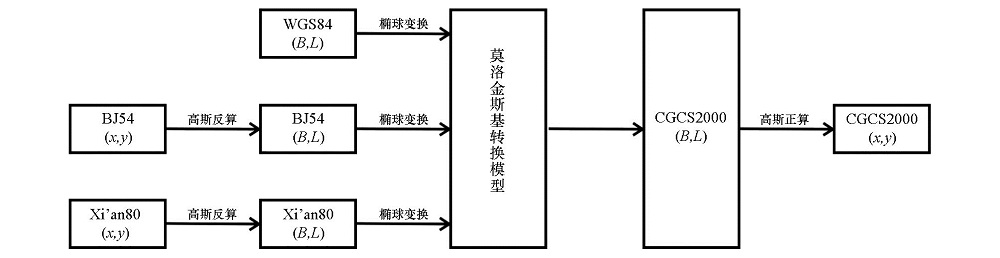
Due to historical reasons, the present coordinate systems of the geological, geophysical and geochemical exploration results are basically WGS84, BJ54 or XA80 systems; nevertheless, according to the NASG requirements on the overall use of CGCS2000 coordinates, in the future the coordinates for all kinds of results should be CGCS2000 coordinates, which causes inconvenient situation in using the results and in comprehensive research work. As a professional geographic information system software, ArcGIS has a wide range of applications in various walks. In this paper, the authors briefly introduced the ArcGIS built-in coordinate system, studied and deduced the calculation formula of the MOLODENSKY coordinate conversion method in ArcGIS, put forward the method to get the conversion and precision evaluation of transformation parameters between different ellipsoids, and cited practical examples for verification. On such a basis, the specific ideas and points for attention were analyzed for each coordinate system in the conversion of ArcGIS software to CGCS2000.
杜辉, 耿涛, 刘生荣, 白运. 基于ArcGIS的地物化成果各坐标系统向CGCS2000坐标转换研究[J]. 物探与化探, 2018, 42(5): 1076-1080.
Hui DU, Tao GENG, Sheng-Rong LIU, Yun BAI. A study of transformation of the coordinate system from geophysical and geochemical results coordinate to CGCS2000 coordinate in ArcGIS. Geophysical and Geochemical Exploration, 2018, 42(5): 1076-1080.