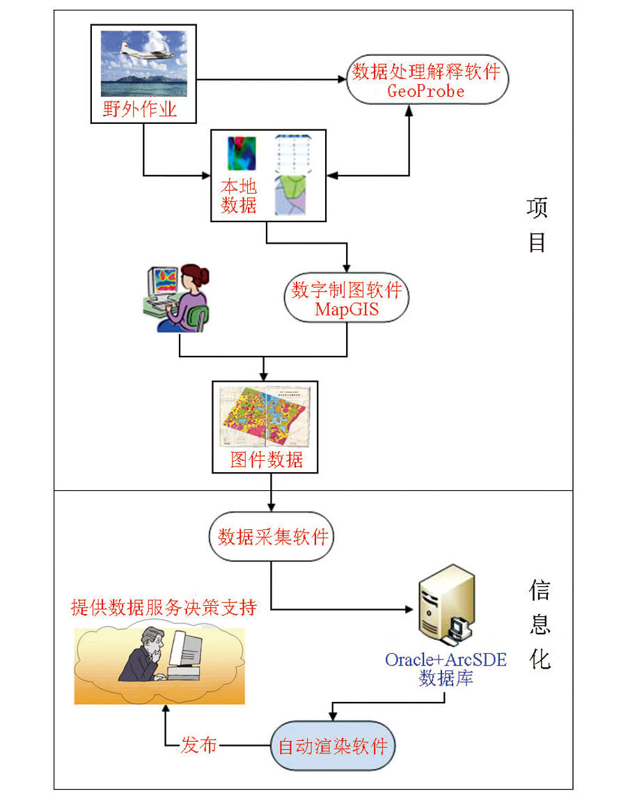
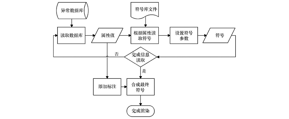
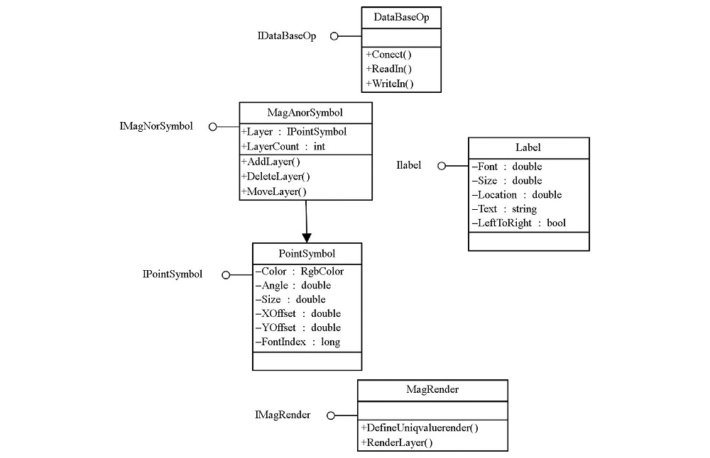
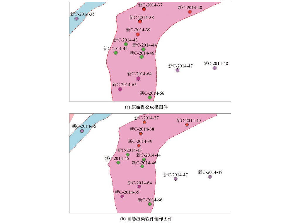
Aeromagnetic anomaly data constitute one of the most important achievements in aeromagnetic work. It is the qualitative analysis of obtained aeromagnetic data via evaluation and interpretation. In order to meet the need of cartographic representation of final production map compiled by researchers in specific project, cartographers need to render the same data several times via different attributes. An Oracle database must be built as the unified storage and management platform so that the airborne geophysical data and information service can be provided efficiently. The authors investigated the mapping requirement of aeromagnetic anomaly and, in combination with management of Oracle database, constructed an auto-renderring model for aeromagnetic anomaly data. Then the authors implemented secondary development of auto-renderring workflow using C# language based on ArcEngine. Tests based on database data have validated that the results meet the standards. Now standardized API interfaces can be provided for other software development.
Guo Z H, Xu K . The Development and construction of aeromagnetic anomaly management information system of China[J]. Progress in Geophysics, 2002(4):203-710.
Wang L F, Xue D J, Li F , et al. The study and application of sharing technology to aeromagnetic data[J]. Geophysical and Geochemical Exploration, 2015,39(S1):152-156.
Lu Z P, Xiao D S, Ma X G . Comparison and influence between new cartographic technology and traditional map compilation[J]. XinJiang Geology, 2003(3):368.
He H, Xue D J, Wang L F . The design and software realization of coordinate transormation for the geophysical data processing and interpretation system[J]. Geophysical and Geochemical Exploration, 2014,38(5):1060-1063.
Du P, Liu T, Li D K , et al. Rapid mapping of emergency scenario and cartographic information transmission[J]. Acta Geodaetica et Cartographica Sinica, 2019(6):747-755.
Li X L, Gao X Z, Shang Y T , et al. Study on the technology of rapid geological mapping based on the database drive[J]. China Mining Magazine, 2018(27):88-92.
Xu W B . Use GIS data to express and update maps[J]. Low Carbon World, 2018(11):90-91.
[13]
Zhou J X, Li Z, Chen Q , et al. The establishment of the SAR images database system based on Oracle and ArcSDE[J]. IOP Conference Series: Earth and Environmental Science, 2014(17):012267.
Feng L, Zhou W, Chen Y , et al. Research on technology of batch customizing aero geophysical survey regions maps[J]. Geophysical and Geochemical Exploration, 2019,43(1):153-160.
Yang Y . A brief discussion on the rapid mapping system of geological Hazards in Xinjiang[J]. Geomatics and Spatial Information Technology, 2018(10):196-198.