

0 引言
1 区域地质概况
滨里海盆地位于东欧克拉通的东南边缘,呈环状阶梯式下坳,是世界上大型深坳陷盆地之一。根据盆地的结构特征可将其划分为4个构造单元:南部次盆、东部次盆、北部—西北部次盆及中央次盆。盆地东缘阿克若尔区块位于东部次盆的阿斯特拉罕—阿克托别隆起带上,石炭系碳酸盐岩顶面构造形态整体为东高西低的缓坡特征,发育一系列低幅度构造圈闭[3-4]。研究区石炭系碳酸盐岩上覆的下二叠统地层岩性复杂,整体以灰岩、泥灰岩、泥岩互层沉积,纵向上速度变化大。此外,局部发育碳酸盐岩礁滩异常体,引起时间域地震剖面上的众多假象,特别是异常体下的石炭系地层构造识别方面难度较大;而且阿克若尔区块构造幅度整体较低,异常体发育区及上覆地层速度不准,低幅度构造形态较难识别[5] (图1)。
图1
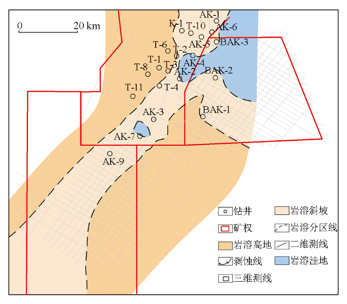
图1
阿克若尔构造带石炭系KT2顶面构造
Fig.1
Top structure of the Carboniferous KT2 in the Akerl structural belt
2 速度建模方法
速度是连接时间域和深度域的纽带,速度的横向变化必然会造成地层的产状和形态在时间、深度域上的差异。具体表现为局部构造高点位置的移动及圈闭面积的变化、地层相对高低产状的变化等[6⇓-8]。对于低幅度构造来说,速度建模要解决的问题主要是提高速度场纵、横向的精度和密度;并准确评估钻井深度与地震计算深度的误差[9-10]。速度建模常用的方法主要包括:①常规的井—震标定时深转换,利用井—震标定的时深关系进行变速成图;②井上速度趋势与地震速度谱协同建模,建立速度场进行变速成图;③叠加速度反演求取层速度的方法,该方法不受水平层状介质及射线垂直入射等前提条件的限制,避免了地层产状复杂时应用Dix公式转换速度产生的误差,求取的层速度精度相对较高;④在具有典型低速异常特征的(曲流沉积等)地层中,一般采用种子点约束空间插值的平均速度场建模方法;该方法首先根据地震资料并结合测井数据和地质分层确定低速异常带的分布;选取已钻井的速度在低速异常带范围内进行空间约束插值,建立速度场并用于时深转换;⑤叠前道集反演技术与叠加速度反演原理相同,不同的是它以原始叠前道集作为输入来反演层速度,克服了叠加速度精度的影响,精度较高,缺点是计算量较大,耗费时间较长[11⇓⇓-14]。
针对研究区石炭系碳酸盐岩上覆下二叠统的复杂地层分布情况、速度的空间变化对下覆低幅度构造的影响,在调研前人速度建模的基础上,本次研究试验了3种速度建模的方法,并进行变速成图,落实低幅度构造形态。
2.1 速度谱与井中速度协同建模
首先对地震速度谱进行分析,上石炭统中部存在一套泥岩层(MKT)分开上下两套碳酸岩层,泥岩上部碳酸盐为KT1,泥岩下部碳酸盐为KT2,以过T-13井的地震剖面和速度谱为例(图2、图3),在纵向上MKT段泥岩低速层,由于精度较低,速度谱未反映出来;此外下二叠统地震杂乱反射的碳酸盐岩异常体部分,速度谱也未能对局部的速度变化有很好的反映,都需要井点速度进行约束校正;其次,在研究区选取测井资料全面、井—震标定可靠的T-13、AK-1、AK-2井,利用其时深关系进行拟合,得到一个速度趋势线(图4);基于生成的速度趋势线插值生成速度体(图5)。该速度趋势纵向精度很高,顶部速度分布也相对合理;利用井时深关系生成的速度趋势模型与叠加速度谱,采用协同克里金方法进行协同速度建模,生成最终的速度模型;叠加速度谱得到的初始速度场与协同建模速度场对比剖面表明,协同建模速度场纵、横向分辨率都得到了很大的提高,展示了速度场内部地质体速度变化的细节,更有利于提高目的层时深转换精度(图6)。
图2
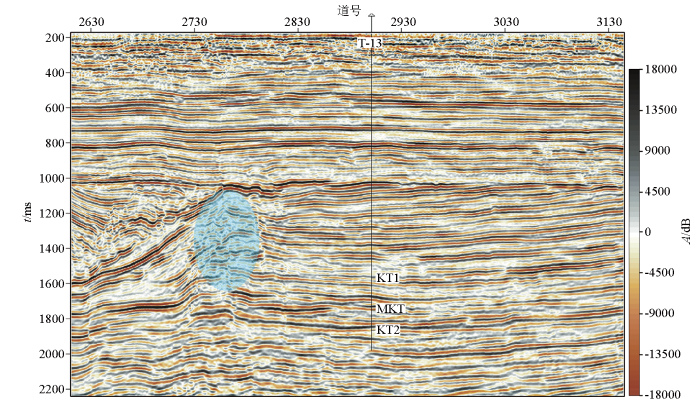
图2
研究区过T-13井近EW向地震剖面
Fig.2
Near east-west seismic profile of well T-13 in the study area
图3
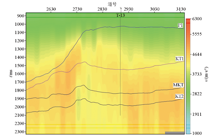
图3
研究区过T-13井近EW向速度谱剖面
Fig.3
Near east-west velocity spectrum profile of well T-13 in the study area
图4
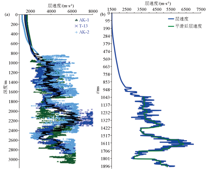
图4
研究区T-13、AK-1、AK-2井的速度趋势线拟合
a—原始速度曲线;b—平滑后速度趋势线
Fig.4
Velocity trend line fitting diagram of wells T-13,AK-1, and AK-2 in the study area
a—original speed curve;b—smoothed speed trend line
图5
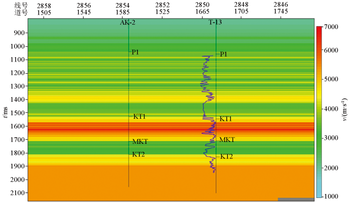
图5
研究区采用井上速度趋势线插值的速度剖面
Fig.5
Velocity profile of the study area using well velocity trend line interpolation
图6
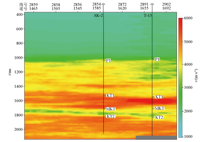
图6
研究区协同建模速度剖面
Fig.6
Velocity profile of collaborative modeling in the research area
2.2 常规井约束层速度反演方法
通过研究单井层速度对比可得,石炭系KT1、MKT、KT2段各井的速度变化规律基本一致;下二叠统岩性相对复杂,泥岩、泥灰岩、灰岩互层,其底部存在一套相对稳定的泥岩—泥灰岩低速层,向北逐渐增厚的趋势(图7)。
图7
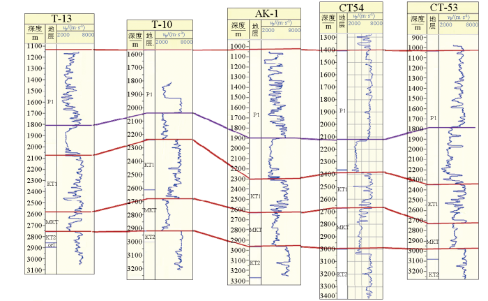
图7
研究区单井层速度对比
Fig.7
Comparison of Single well formation velocities in the study area
为了进一步提高石炭系和下二叠统层速度的准确性,利用构造解释得到的层位数据,结合测井得到的声波时差数据,利用地震资料反演方法获得目的层段的层速度,并将目的层之上的协同建模得到的速度场与反演得到的目的层段的层速度进行拟合,获取最终时深转换速度场(图8),此方法的关键为融入了反演速度信息,进一步提高速度场模型构建的精度。
图8
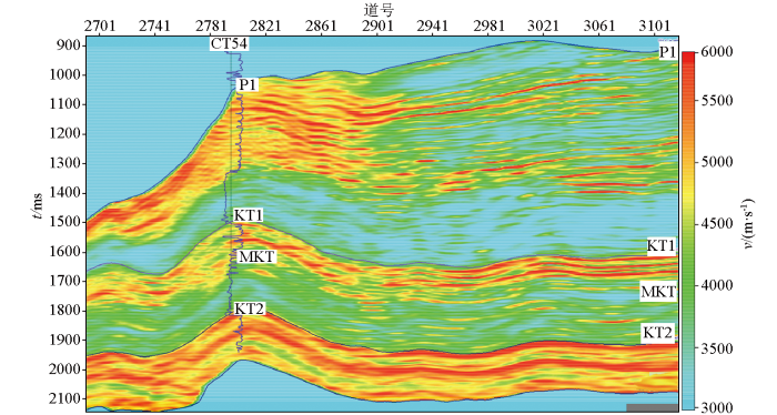
图8
研究区近EW向层速度反演剖面
Fig.8
Inversion profile of near east-west layer velocity in the study area
将上覆地震速度体与目的层(下二叠统、石炭系KT1、MKT、KT2)反演速度相融合,并将层速度转换为平均速度(图9)。过CT54井平均速度剖面表明速度场具有从浅向深平均速度逐渐增大的趋势,横向速度变化较自然,为后续时深转换奠定了一定的数据基础。
图9
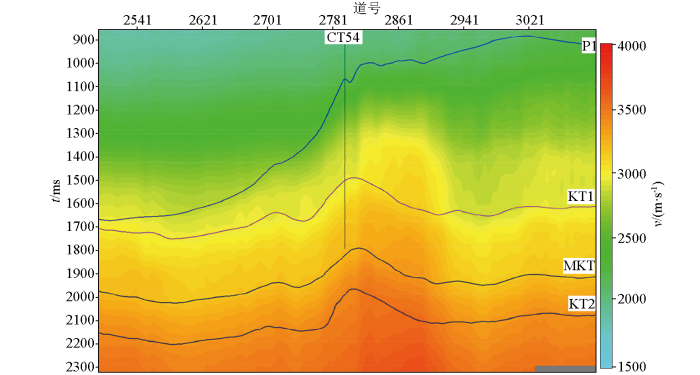
图9
研究区近EW向平均速度剖面
Fig.9
Profile of near east-west average velocity in the study area
2.3 分频层速度反演技术
图10
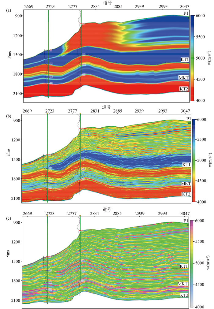
图10
研究区近EW向分频反演速度剖面
a—低频反演;b—中频反演;c—高频反演
Fig.10
Velocity profile of near east-west frequency inversion in the study area
a—low frequency inversion;b—intermediate frequency inversion;c—high frequency inversion
图11
图11
研究区不同走向分频反演速度剖面
a—近SN向分频反演结果;b—近EW向分频反演结果
Fig.11
Velocity profile of different direction frequency division inversion in the study area
a—near north-south direction frequency division inversion;b—near east-west direction frequency division inversion
3 实例应用与效果
常规井约束层速度反演与分频速度反演得到的研究区层速度剖面对比分析,表明分频速度反演刻画的下二叠统碳酸盐岩异常体的速度异常范围更为准确,与地震剖面反射特征吻合度更高(图12);纵向上的下二叠统、石炭系KT1、MKT、KT2段泥灰岩、泥岩、灰岩地层的速度变化更为精细。利用上述方法得到层速度,进一步转换成平均速度场,开展阿克若尔区块的时深转换;以石炭系KT2段顶面等T0与构造图对比为例,等T0图与构造图整体构造形态较为一致,局部有一定的差异,中部NE向异常体隆起区时深转换之后幅度较低,隆起区连续性也较等T0图降低;采用分频反演速度转换的构造形态与采用速度谱转换的构造形态也有差异,在区域东半部分前者与T0图的趋势更为接近(图13);此外AK-5井在石炭系KT2段的试油获得高产,使用10 mm油嘴,酸压后日产油112.9 m3/天,证实了该井处局部低幅度构造的可靠性。
图12
图12
研究区过T-13井近EW向常规井约束层速度反演与分频速度反演得到的速度剖面对比分析
a—常规井约束反演层速度剖面;b—分频反演层速度剖面;c—地震反射特征剖面
Fig.12
Comparative analysis of velocity profiles obtained from constrained layer velocity inversion and frequency division velocity inversion in the near east-west conventional well of T-13 in the research area
a—velocity profile of conventional well constrained inversion layer;b—velocity profile of frequency division inversion layer;c—seismic reflection characteristic profile
图13
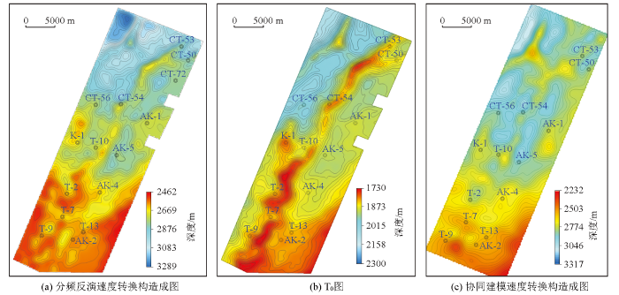
图13
研究区石炭系KT2顶面构造图与T0图对比
Fig.13
Comparison between the top structure map of the Carboniferous KT2 in the study area and the T0 map
表1 分频反演方法建立速度场时深转换的误差统计
Table 1
| 井号 | KT2深 度/m | 构造图 深度/m | 绝对误 差/m | 相对误 差/‰ |
|---|---|---|---|---|
| T-10 | 2708.5 | 2720 | -11.5 | 4.93 |
| T-9 | 2549.55 | 2562 | -12.45 | 5.72 |
| T-7 | 2593 | 2615 | -22 | 8.48 |
| T-2 | 2629.4 | 2612 | 17.4 | 6.62 |
| T-13 | 2580.72 | 2584 | -3.28 | 1.27 |
| K-1 | 2696 | 2670 | 26 | 9.64 |
| CT-56 | 2745.3 | 2768 | -22.7 | 8.26 |
| CT-53 | 2816.1 | 2843 | -26.9 | 9.55 |
| CT-50 | 2801.8 | 2833 | -21.2 | 7.13 |
| AK-4 | 2633.7 | 2639 | -5.3 | 2.01 |
| AK-2 | 2581.89 | 2580 | 1.89 | 0.73 |
| AK-1 | 2718.39 | 2718 | 0.39 | 0.14 |
| CT-54 | 2792 | 2778 | 14 | 5.01 |
表2 协同建模方法建立速度场时深转换的误差统计
Table 2
| 井号 | KT2 深度/m | 构造图 深度/m | 绝对误 差/m | 相对误 差/‰ |
|---|---|---|---|---|
| T-10 | 2708.5 | 2800 | -91.5 | 33.78 |
| T-9 | 2549.55 | 2530 | 19.55 | 7.66 |
| T-7 | 2593 | 2570 | 23 | 8.87 |
| T-2 | 2629.4 | 2766 | -136.6 | 51.9 |
| T-13 | 2580.72 | 2580 | 0.72 | 0.27 |
| K-1 | 2696 | 2770 | -74 | 27.44 |
| CT-56 | 2745.3 | 2890 | -144.7 | 52.7 |
| CT-53 | 2816.1 | 2840 | -23.9 | 8.48 |
| CT-50 | 2801.8 | 2850 | -48.2 | 17.2 |
| AK-4 | 2633.7 | 2700 | -66.3 | 25.1 |
| AK-2 | 2581.89 | 2575 | 6.89 | 2.66 |
| AK-1 | 2718.39 | 2785 | -66.61 | 24.5 |
| CT-54 | 2792 | 2904 | -112 | 40.11 |
4 结论与认识
通过3种速度建模方法对比研究,优选出适用于研究区的速度模型;有效融合了地震成像叠加速度和声波测井速度,建立反演初始模型;利用地震资料反演方法获得目的层段的层速度数据,并且将协同建模得到的速度场与反演得到的目的层段层速度进行拟合,获取最终时深转换速度场;在目的层段将低频、中频、高频不同频率域数据体按不同比例合并,得到最终的高精度、高分辨率的层速度体,同时,分频反演层速度的建模方法,在纵向、横向上反映的速度变化更为精确。
应用本文的速度模型,明显提高了滨里海盆地东缘阿克若尔地区石炭系碳酸盐岩顶面低幅度构造成像精度,更好地刻画出目的层构造特征,与钻井资料的吻合度较高,为落实阿克若尔地区石炭系低幅度构造提供了有利的技术支撑。
该方法具有普遍适用性,对相似地质条件下低幅构造成像有一定的借鉴意义。
参考文献
滨里海盆地东缘盐下油气成藏特征与主控因素
[J].
DOI:10.3969/j.issn.1672-7703.2020.04.013
[本文引用: 1]

滨里海盆地盐下油气资源十分丰富,是世界重要的油气产地。盆地东缘受古隆起和乌拉尔造山运动双重 影响,油气成藏控制因素复杂。通过分析油气成藏要素特点和成藏模式,提出油气成藏主控因素。盆地东缘油气成藏 与乌拉尔洋俯冲—消减—关闭的过程密切相关,这一过程产生的古裂谷、古隆起控制了油气藏的形成。古裂谷控制生 烃中心,裂谷作用产生的断裂成为油气运移主通道;古隆起控制早期碳酸盐台地形成及其上优质储层发育,同时也是 油气聚集的重要指向区;乌拉尔造山运动控制后期碳酸盐台地形成,乌拉尔造山带及其他海西期造山带使盆地演化为 封闭海环境,形成全盆地分布的空谷阶盐岩优质盖层,碰撞造山过程产生的断裂形成断层相关圈闭、改善储层性能及 导致油气二次成藏。
Characteristics and main controlling factors of sub-salt oil and gas accumulation in the eastern margin of the Precaspian Basin
[J].
哈萨克斯坦滨里海盆地油气地质特征及勘探方向
[J].
Oil-gas geological features and its exploration direction in marginal caspian basin,Kazakhstan
[J].
滨里海盆地与塔里木盆地油气地质特征的类比
[J].
Analogy of petroleum geological characteristics between the Caspian Basin and the Tarim Basin
[J].
哈萨克斯坦滨里海盆地盐下层系油气成藏组合特征及勘探方向
[J].
Features and exploration trends of hydrocarbon accumulation assemblage of the subsalt strata in Marginal Caspian Basin of Kazakhstan
[J].
地震速度场建立与变速构造成图的一种方法
[J].
A method for building of seismic velocity field and structure mapping by variation in velocity
[J].
低幅度构造成图技术
[J].
Technique for mapping low-amplitude structure
[J].
构造复杂地区地震资料速度和成图方法研究与应用
[J].
Study of seismic data velocity and mapping method in complicated structure area and its application
[J].
低幅度构造变速成图技术
[J].
Variable speed mapping technology of low amplitude structure
[J].
低幅度构造地震解释探讨
[J].随着勘探程度的逐渐提高,储量小,构造幅度低且被断层复杂化的油气藏所占的比例逐年上升,储量品位日趋下降,低幅度构造的勘探逐渐受到重视,编制高精度的构造图是该类构造勘探的一个核心环节。从理论上分析了分辨率和构造成图精度的关系,探讨了在解释阶段研究低幅度构造的可行性及其思路和方法,以达到在资料分辨率基本许可的条件下,利用解释工作方法与技术的改进对低幅度构造进行研究和分析,而不仅仅依赖于高成本重新处理的目的。
Discussion on interpretation of low amplitude structures
[J].The number of low amplitude hydrocarbon reservoirs discovered is climbing as exploration goes into depth. The key to detect this kind of reservoirs is to draw up a high precision structure map. Based on a theoretical analysis of the relationship between resolution and precision of drawing, this paper discussed the feasibility and methods to study the low amplitude structures during data interpretation.
变速成图方法及应用研究
[J].
Research on variable-velocity structure mapping and its application
[J].
变速成图系统技术关键及其在塔中西部的应用
[J].
The varying velocity mapping technique:Its key problems and its application to western Tazhong area
[J].
低幅度构造识别技术在Carmen油田三维工区的应用
[J].
Application of low-amplitude structure recognition technique to the 3-D seismic exploration in the Carmen field
[J].
马头营地区低幅度构造速度建模方法
[J].
Modeling method of low amplitude tectonic velocity in Matouying area
[J].
四川盆地西北部深层低幅度构造建模及成像
[J].
Modeling and imaging of deep low-amplitude structure in northwest Sichuan Basin
[J].
