

0 引言
雄安新区位于河北省保定市境内,地处北京、天津、保定腹地,规划范围涵盖河北省雄县、容城、安新等3个县及周边部分区域,雄安新区是继深圳经济特区和上海浦东新区之后具有全国意义的新区[1],承载着疏解北京非首都功能,调整优化京津冀城市布局和空间结构,培育创新驱动发展新引擎的重要寄望。新区的开发面临着众多工程建设问题,区内浅表古河道较为发育,古河道主要由结构松散、抗压性弱、沉陷性大的砂砾石组成,地震或受力会出现砂土液化、地裂缝或喷水冒沙等情况,不能作为工程建筑的基础,在工程建设前需要进行必要的地质调查,查明古河道平面分布及空间展布特征,规避古河道带来的工程风险。
前人调查古河道时选用的方法技术手段多样,早期以历史文献查阅、地形图判读、野外考察访问等方法为主[2-3],随着科学技术和调查方法的发展,目前对古河道的调查手段主要有航片图、遥感判读、钻探取心、物探、测试等[4⇓⇓⇓-8]。张竞等[9]在雄安新区容城及周边区域地面古河道的划定是基于地表岩性光谱特征遥感解译的结果,而对地面以下古河道的埋深、砂体厚度和古河道空间展布特征还不清楚。针对这些问题,笔者选定有钻孔分布区域为研究区,尝试性地开展高密度电阻率法剖面探测,利用其反演结果精细推断解释了古河道范围、埋深及河道内分流河道的分布特征,研究成果与钻探揭示情况基本一致,高密度电阻率法确定的古河道分布范围具有较高的准确度,应用效果显著。表明利用遥感和物探方法组合在雄安新区精细化探测浅表古河道是有效可行的,为今后探测和研究浅表古河道提供了新思路。
综合前人研究成果,华北平原古河道的重要标志是具有明显的二层结构,即一般由下部的厚层砂体和上部的亚砂土、亚黏土及黏土薄层(间有粉砂层)组成[10]。从研究区电性特征分析,砂层和黏土层具有明显的电性差异,为高密度电阻率法探测提供了地球物理前提。利用该物探方法研究地下介质电阻率分布特征,结合区域古河道分布规律,可达到快速、经济、高效精细化探测浅表古河道的目的。
1 研究区概况
雄安新区区位优势明显,交通便捷,生态环境优良,资源环境承载力较强。全境内地势由NW向SE逐渐降低,地面高程多在5~26 m,地形坡降小于2‰。新区西北部距离太行山区不足30 km,河流进入平原后能量得以释放,形成了发达的水系网。本次研究选择雄安新区西北部容城县容城镇王果庄村及邻近区域作为研究浅表古河道探测区域。该区经遥感解译有NW、NNE和近似SN向地面古河道分布,解释河道宽度约2.4 km,研究区施工条件良好。
1.1 浅表地层特征
雄县—容城—安新全境及周边部分地区地表出露地层为第四系松散层,区内浅层沉积物主要为第四纪以来冲洪积、冲积和冲湖积形成,岩性以粉质黏土、粉土、粉砂、中细砂和黏土为主[11]。研究区新生界自上而下主要由以下层位构成:
1)全新统(Qh):全新统底板埋深一般7~12 m,主要为冲积、冲(洪)积—湖积和湖积的堆积物。下部岩性为灰黄色粉质黏土和粉土,上部岩性多为黄棕色粉土。
2)上更新统(Q3):上更新统底板埋深一般50~60 m,主要为冲洪积、冲(洪)积—湖积的堆积物,岩性以粉质黏土、粉土及不同粒级的砂、砂砾石为主。
3)中更新统(Q2):中更新统底板埋深一般70~80 m,主要为冲洪积、冲(洪)积—湖积的含砂粉质黏土、黏土夹砂及砂砾石的堆积物。
4)下更新统(Q1):下更新统覆盖于新近系之上,底板埋深约300 m,主要为冲洪积及冲(洪)积—湖积黏土、粉质黏土夹砂砾石。
1.2 地球物理特征
表1 研究区岩(土)层物性参数统计
Table 1
| 岩 性 | 常见电阻率值/(Ω·m) |
|---|---|
| 黏土、粉质黏土 | 5~25 |
| 砂质黏土 | 30~55 |
| 细砂、粉砂 | 35~90 |
| 中细砂 | 75~140 |
2 研究技术方法
2.1 高密度电阻率法
高密度电阻率法在实际应用时,常根据地表和探测目标的深度、大小、产状等因素,选取最适合的电极排列类型探测,装置类型主要包括温纳装置、偶极—偶极装置、三极装置、温纳—斯伦贝谢装置等[24]。温纳装置对电阻率的垂向变化比较敏感,一般用来探测水平目标体,可观测到较强的信号,是高密度电阻率法中比较常用的观测装置。本次工作选用的仪器为骄鹏集团生产的GEOPEN E60DN型高密度电阻率仪,野外数据采集采用温纳α装置,点距为5 m,采集层数为16,探测深度约45 m。
2.2 野外工作方法
根据雄安新区容城及周边区域遥感解译的地面古河道分布结果[9]和研究区的7个第四系地层钻孔,结合实地踏勘情况,选择过C3、C4、C5钻孔布设1条EW向剖面L1,该剖面方向垂直遥感解译古河道的走向,测线长度5 050 m,测线方位角89°;在过C4钻孔布设1条近SN向剖面L2,测线长度1 585 m,测线方位角175°,选定的研究区范围和2条剖面布设位置见图1,目的是通过2条剖面勘查并结合已知钻孔情况,查明浅表古河道边界范围和埋深,同时在古河道内布设近SN向剖面L2,研究浅表古河道内分流河道的分布特征,为雄安新区浅表古河道精细化探测提供技术方法思路。为确定在不同点距条件下精细探测浅表古河道横向边界和古河道上下界面的垂向分辨程度,在L1线上遥感解译地面古河道左边界位置处设置了剖面L0,开展了1 m、2.5 m、5 m和10 m不同点距高密度电阻率法试验。
图1
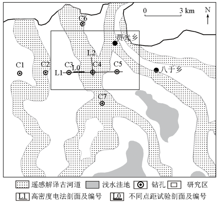
高密度电阻率法剖面测点位置使用RTK放样,采用剖面相对位置,起始点为0 m,L1剖面自西向东放样,L2剖面自北向南放样,L0不同点距试验剖面按照L1剖面坐标来执行。根据L1剖面遥感解译的地面古河道左侧大致边界位置,首先在剖面1 440~1 980 m做10 m点距高密度电阻率法剖面测量,采集数据经过畸变点剔除、地形校正等预处理后,利用处理软件RES2DINV对预处理数据进行最小二乘法反演得到电阻率反演断面[25-26],根据电阻率的变化特征,结合研究区电性物性统计,通过查找浅部低电阻背景下的高电阻异常砂体,进而确定浅表古河道位置和范围。从反演断面图2中10 m点距剖面可以看出,古河道左侧边界在1 675 m附近,然后以此位置为中心位置开展1 m、2.5 m和5 m不同点距高密度电阻率法试验剖面测量。
图2
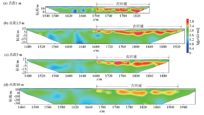
图2
L0线不同点距高密度电阻率法试验反演结果对比
Fig.2
Comparison of test inversion results of high-density resistivity method with different point spacings of L0 line
2.3 不同点距试验结果分析
L0线不同点距高密度电阻率法反演结果见图2。从图中可以看出4种结果都较明显地显示出古河道的边界,其中点距1 m和2.5 m结果反映的古河道水平分布特征更为精细,而点距10 m的结果在水平连续性上稍差,表明随着观测点距的增大,水平向分辨率随之下降,不利于确定古河道砂体的连续性和分布范围。通过对不同点距试验剖面解释古河道的上下界面标高统计(表2)后发现,点距1 m和2.5 m所解释的古河道的上顶板和下底板和砂层厚度较为接近,上顶板的标高约为9.3 m,埋深约为1.6 m,通过与已知钻孔C4相比,C4处古河道的埋深1.5 m左右,反演解释结果与钻孔揭露情况较为接近;点距5 m和10 m解释的古河道砂体厚度分别约为8.5 m和8 m,与钻孔C4揭示砂体厚度8.7 m较为接近,且上顶板标高分别约为7.6 m和6.1 m,埋深大于2.5 m,与实际情况存在一定的差别,分析其原因为大点距的高密度电阻率法在浅部具有一定的采集盲区,并且随着点距的增大,其垂向分辨率随之下降。
表2 不同点距高密度电阻率法反演解释古河道上顶板、下底板和砂层厚度统计
Table 2
| 点距 | 指标/m | x/m | 均值/m | ||||||||||||
|---|---|---|---|---|---|---|---|---|---|---|---|---|---|---|---|
| 1690 | 1710 | 1730 | 1750 | 1770 | 1790 | 1810 | 1830 | 1850 | 1870 | 1890 | 1910 | 1930 | |||
| 1 m | 上顶板标高 | 11.83 | 8.88 | 8.44 | 9.62 | 8.00 | 9.18 | 9.33 | |||||||
| 下底板标高 | 1.80 | 2.39 | 5.05 | 0.92 | 0.92 | 0.18 | 1.88 | ||||||||
| 砂层厚度 | 10.03 | 6.49 | 3.39 | 8.70 | 7.08 | 9.00 | 7.45 | ||||||||
| 2.5 m | 上顶板标高 | 11.25 | 8.10 | 8.29 | 9.68 | 8.49 | 8.89 | 6.91 | 8.69 | 9.28 | 8.49 | 11.45 | 11.25 | 10.27 | 9.31 |
| 下底板标高 | 4.74 | 2.17 | 6.71 | 2.37 | -1.18 | -1.58 | -5.92 | 0.40 | 3.56 | -2.37 | 4.15 | 3.75 | 7.50 | 1.87 | |
| 砂层厚度 | 6.51 | 5.92 | 1.58 | 7.30 | 9.67 | 10.46 | 12.83 | 8.29 | 5.72 | 10.86 | 7.30 | 7.50 | 2.76 | 7.44 | |
| 5 m | 上顶板标高 | 10.43 | 7.28 | 5.51 | 9.64 | 6.49 | 4.52 | 7.87 | 8.66 | 7.67 | 7.56 | ||||
| 下底板标高 | 4.13 | 2.15 | 1.17 | -2.38 | -1.59 | -3.36 | -6.12 | -3.56 | 1.37 | -0.91 | |||||
| 砂层厚度 | 6.31 | 5.12 | 4.34 | 12.02 | 8.08 | 7.88 | 13.99 | 12.22 | 6.31 | 8.47 | |||||
| 10 m | 上顶板标高 | 9.05 | 3.84 | 9.67 | 7.38 | 6.55 | 5.51 | 2.80 | 6.34 | 4.46 | 4.67 | 6.34 | 6.06 | ||
| 下底板标高 | 1.97 | 1.97 | -1.57 | -4.07 | -4.07 | -6.78 | 0.72 | -3.03 | -1.57 | -3.45 | -0.95 | -1.90 | |||
| 砂层厚度 | 7.08 | 1.87 | 11.24 | 11.45 | 10.62 | 12.29 | 2.08 | 9.37 | 6.04 | 8.12 | 7.29 | 7.95 | |||
通过不同点距的参数试验,在探测浅表古河道的分布范围时,从工作效率和分辨率综合考虑,建议选择5 m点距作为探测浅表古河道的点距参数。同时,根据其他点距的水平及垂向分辨率变化规律,发现点距1 m和2.5 m在探测古河道上顶板和下底板中具有更好的精度,在以后的工作中可根据不同探测目标和工作目的来开展不同点距的高密度电阻率法工作。
3 资料解释和结果分析
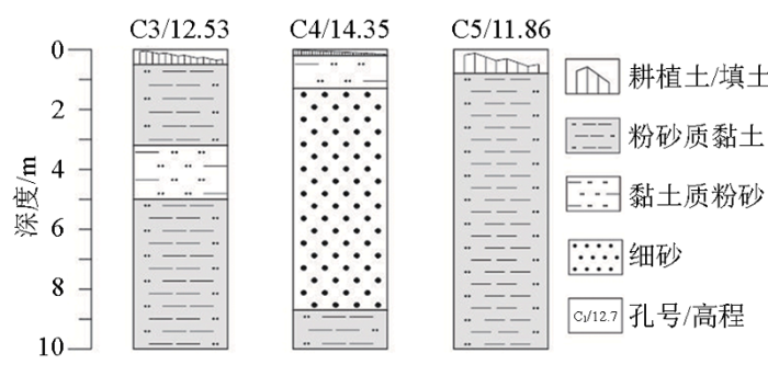
高密度电阻率法剖面穿过3个第四系钻孔,编号为C3、C4、C5,钻孔深度为10 m,钻孔地质柱状图见图3。根据C3~C5钻孔揭示的岩性,C4孔岩心呈砂层、黏性土层的二元结构,表层砂层以细砂、粉砂质黏土为主, 砂层厚度为8.7 m;C3和C5岩心呈黏性土单层或黏性土夹砂层结构, 黏性土层总厚度7.0~10.0 m。
图3
3.1 断面特征分析及钻孔验证
对原始数据预处理后,利用软件RES2DINV进行反演得到电阻率反演断面,根据电性特征对其进行推断解释。由于L1测线较长,分三段进行显示(图4),可以看出L1线整体剖面电性特征呈“低—高—中”三层分布。纵向上,上层细分为“低—中”两层电性结构,对应的地层为粉质黏土和粉土;中层表现为相对高阻层电性结构,对应的地层为细砂和粉土夹层;下层表现为“中—低”的二层电性结构,对应的地层为粉土和粉质黏土。其中在1 675~1 920 m段和2 135~2 700 m段电阻率为相对高阻,根据物性特征推断为古河道砂体反映,从反演断面图可以看出,两段高阻体并不连续,推断该剖面上有2条古河道分布,其中第一段古河道的宽度约245 m,第二段古河道的宽度约565 m。L2线为顺古河道分布范围走向布设的测线,从反演断面图(图5)可以看出,在测线的浅部有一层高阻体分布,是古河道砂体反映,其中在760~950 m段高阻体消失,推断该古河道具有“弯曲”、“迂回”的分布特征。
图4
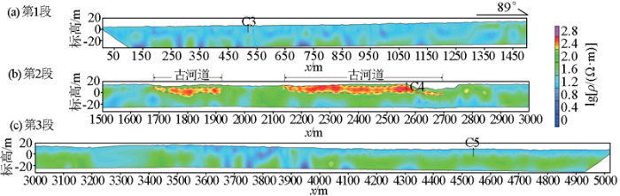
图4
L1线高密度电阻率法反演解释
Fig.4
Inversion result and interpretation of L1 high density resistivity method
图5
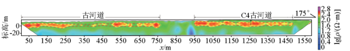
图5
L2线高密度电阻率法反演解释
Fig.5
Inversion result and interpretation of L2 high density resistivity method
钻孔C4位于L1剖面上2 570 m处,为高密度电阻率法反演剖面解释古河道砂体部位,从解释图可以看出砂体上顶板标高约为11.5 m,下底板标高约为2 m,高密度电阻率法解释砂体厚度为9.5 m左右,与C4第四系钻孔揭露砂体厚度8.7 m基本吻合,钻孔揭示地层情况与高密度电阻率法反演断面解释结果一致,均为以细砂、粉砂和粉质黏土为主的砂层。从C4钻孔的验证结果来看,高密度电阻率法在雄安新区浅表古河道精细化探测是有效的,应用效果显著。
3.2 平面特征分析
从L1和L2两条高密度电阻率法反演断面解释图可见,2条剖面所在的研究区域在横向上是由2条分流古河道组成,并不是1条古河道,这从侧面证实了华北平原的浅表古河道具有“辫状”“弯曲”和“迂回”的分布特征。利用遥感地表岩性光谱采集分析方法解译的地面古河道分布宽度范围约为2.4 km,而从EW向L1高密度电阻率法反演断面图上显示2条浅表古河道的宽度分别为245 m和565 m,表明了利用高密度电阻率法物探手段可以对浅表古河道地表以下古河道特征进行详细的评价和更精细的定位;从近SN向L2高密度电阻率法反演断面解释的古河道在SN向上具有“弯曲”、“迂回”的分布特征。
在遥感解译地面古河道的基础上,利用2条高密度电阻率法剖面的测量成果,探明了剖面所在研究区浅表古河道边界范围、埋深及河道内分布特征,对研究区浅表古河道分布进行精细的划分,见图6。利用高密度电阻率法所划定的古河道分布范围具有较高的准确度,实现了精细探测目的,取得了良好的应用效果。
图6
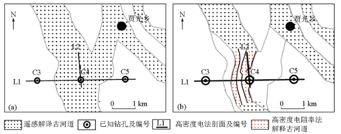
图6
遥感和高密度电阻率法解译研究区浅表古河道分布范围
a—遥感解译地面古河道分布范围;b—物探解释研究区浅表古河道分布范围
Fig.6
Distribution range of shallow paleochannels by remote sensing interpretation and the high density resistivity method interpretation
a—distribution range of paleochannels by remote sensing interpretation;b—distribution range of shallow paleochannels by geophysical interpretation
4 结论
1)本文在遥感解译地面古河道的基础上,过第四系钻孔开展两条高密度电阻率法剖面测量,查明研究区浅表古河道边界范围、埋深及河道内分布特征,对研究区浅表古河道分布进行精细划分。经钻孔验证,钻孔揭示古河道地层和砂体厚度与高密度电阻率法反演断面解释结果基本一致,表明在识别和精细化探测雄安新区浅表古河道问题上,利用遥感方法进行“宏观性”快速确定区域地面古河道的分布情况,在局部重点研究区进行高密度电阻率法“精细化”探测浅表古河道埋深、砂体厚度和空间展布特征,遥感和物探组合在雄安新区浅表古河道精细化探测是有效可行的,为今后探测和研究浅表古河道提供了新思路。
2)高密度电阻率法所划定的浅表古河道分布范围具有较高的准确度,对浅表古河道能进行详细的评价和更精细的定位,探明研究区内古河道具有“弯曲”、“迂回”和“辫状”的平面分布特征,取得了良好的应用效果,为今后精细化探测和研究浅表古河道方法选择和研究思路提供借鉴和参考。
3)通过不同点距(1 m、2.5 m、5 m和10 m)高密度电阻率法在雄安新区浅表古河道精细化探测试验,4种点距在探测和识别古河道方面都具有良好的应用效果,从经济、高效和分辨率综合因素考虑,建议今后探测浅表古河道可选择5 m点距参数开展高密度电阻率剖面测量;点距1 m和2.5 m探测浅表古河道具有更好的水平和垂向分辨精度,在探测和识别上顶板和下底板中具有更高的精度,在实际工作中可根据不同的工作目的,选择不同的点距参数来开展调查工作。
参考文献
雄安新区地上地下工程建设适宜性一体化评价
[J].
A study of engineering construction suitability integrated evaluation of surface-underground space in Xiong’an New Area
[J].
河北平原的浅埋古河道
[J].
DOI:10.11821/xb198604005
[本文引用: 1]

河北平原埋深8—30m的砂层透镜体,呈一定方向的条带状分布,具有许多河流相沉积标志。相对于地面出露古河道(埋深0—8m)和深部埋藏古河道(埋深60—100m以下),我们称之为浅部埋藏古河道,简称浅埋古河道。
The shallow buried paleochannels in Hebei plain
[J].
华北平原古河道的形成研究
[J].
Study on the formation of paleochannels in North China Plain
[J].
基于遥感技术的静海县浅埋古河道分析
[J].
Research on the distribution and characteristic of the shallow buried ancient channel in Jinghai county
[J].
近20年来中国古河道研究进展
[J].
Progresses of palaeochannel studies in China in the past 20 years
[J].
DOI:10.11820/dlkxjz.2013.01.001
[本文引用: 1]
The last 20 years have seen new progresses in palaeochannel studies in China, including the investigations on palaeochannels in Nenjiang Daan, palaeochannels in the plain south of Laizhou bay, and palaeochannels, deep ancient grooves and submarine palaeochannels in the Yangtze river downstream of Nanjing, and so on. As a result, a large number of achievements have been accomplished, and new theories proposed; the research achievements have found new applications as well. The new knowledge and new theories indicate that buried palaeochannels exist in all of large outflowing rivers in China since the LGM(Last Glacial Maximum). The palaeochannel runs deep into the stadial terrestrial and the sea bed of the continental shelf from the Last Glacial Epoch, forming a cutting valley with deep grooves at the bottom, stacked with fluvial carryover and coarse particulate material from the LGM and early Holocene. The upper part of the valley is covered with marine, paralic, and continental fine-grained material from the Holocene, which frames the shallow-buried palaeochannel with 20 m to 50 m depth. Palaeochannels are rich in underground water, and an important water source for the areas of alluvial plain and shallow continental shelf.
半航空顺变电磁法在古河道结构探测中的应用
[J].
Application of semi-airborne TEM to structure exploration in the old channels
[J].
物探及遥感资料在腾格尔坳陷古河谷(道)研究中的应用
[J].
Application of geophysical and remote sensing data in the study of pa;eovalley in the Tengeer depression
[J].
综合物探方法在浅埋古河道调查中的应用研究
[J],
Study on the application of integrated geophysical method in the investigation of shallow-buried ancient channel
[J].
基于岩性光谱特征的雄安新区地面古河道识别研究
[J].
A study of Paleochannels interpretation by the spectrum of lithology in Xiong'an New Area
[J].
华北平原古河道发育的环境条件及其沉积特征
[J].
DOI:10.11821/yj1983040006
[本文引用: 1]
全新世以来,气候和新构造运动控制了华北平原古河道的发育,而许多重要河流由于流经黄土地区,搬运和沉积了大量粒径为0.01-0.25毫米的泥沙,因而加速了河道的变迁。此外,地貌、人类活动等因素也在不同程度上影响了古河道的发育。在华北平原环境条件的影响下,古河道在空间分布、地貌形态、地层结构、颗粒特征、物质成分乃至所含化石等方面,都呈现比较明显的沉积特征,这些特征可以作为识别全新世以来华北平原古河道的指标。
The environmental conditions of the development of paleoghannels in the Hua Bei (North China) plain and their sedimental characteristics
[J].
DOI:10.11821/yj1983040006
[本文引用: 1]
Since the Holocene,climatic changes and neotectonic movements have controlled the development of paleochannels on the Huabei Plain,Some major rivers flow over loess regions.The transport a great deal of load,and most of the particles are within the size range 0.01-0.25mm.It has brought changes to the channels at great speed.Besides,the reliefs and artificial action have influenced the development of paleochannels.Distribution of paleochannels on the Huabei Plain is characterized by radial pattern.They are separately distributed in two types of landforms:strip highland and trough-shaped depression.The composition of materials contain two layers,the lower layer of deposits is thick sand body,and the upper layer of deposits consists primarily of thin loam and/or clay strata.The structures of paleochannel deposit show horizontal thin bedding and various cross-bedding in the order of up-and-down.The grain sizes of the composition of materials are smaller.The average psephicity is less than moderate.The sand body of the paleochannel presents long prism in geometry.The mineral assemblages of paleochannels in Hua Bei Plain are different and complex.The paleochannels in Huabei Plain are rich in ground water,which commonly contain less salt,but fossils are less.The electric character-istics of paleochannels show reaction of high resistance.
雄安新区城市地下空间探测技术研究
[J].
Geophysical technology for underground space exploration in Xiong'an New Area
[J].
二连盆地中部古河道砂岩型铀矿综合地球物理响应特征研究
[J].
Study of integrated geophysical characteristics of paleo-valley sandstone-type uranium deposits in the middle of the Erenhot basin
[J].
高密度电阻率法在三星堆壕沟考古勘探中应用研究
[J].
The archaeological application of high-density resistivity method to ditch exploration on Sanxingdui Site
[J].
基于多源遥感数据的古河道识别方法——以磴口地区古黄河河道为例
[J].
Identification of ancient river channels based on multi-source remote sensing data:Take the ancient Yellow River channel in Dengkou area as an example
[J].
综合物探方法在古河道型地下水库工程建设中的应用研究
[J].
Application and research of integrated geophysical method in construction of paleochannel groundwater reservoir
[J].
徐州地区全新世古河道地电特征研究
[J].
Research on geoelectric characteristics of Holocene ancient channels in Xuzhou area
[J].
综合电法在探测海水入侵界面中的研究与应用——以莱州湾地区为例
[J].
Research and application of comprehensive electrical method in detecting saltwater intrusion interface:A case study of Laizhou Bay area
[J].
高密度电阻率法与地质雷达法在土壤厚度调查中应用效果——以西昌市土壤厚度调查为例
[J].
Application of high density resistivity and geological radar in soil thickness survey:a case study of the soil thickness survey in Xichang
[J].
利用电测深法探测泃河与错河古河道
[J].
Old course detection of Juhe and Cuohe river by electric sounding method
[J].
包头市固阳县矿集区高密度电阻率法找水定井实例分析
[J].
A case analysis of multielectrode resistivity method for determining a well location in groundwater prospecting in the ore concentration area of Guyang County’Baotou city
[J].
高密度电阻率法在咸水入侵监测中的应用
[J].
The application of high density electrical resistivity method to monitoring saltwater intrusion
[J].
基于高密度电法温纳装置的三维电阻率反演应用
[J].
Application of 3-D resistivity inversion based on Winner device of high density electricity method
[J].
高密度电阻率法在天津市七里海牡蛎礁博物馆选址中的应用
[J].
Application of high density resistivity method on site-selection for the oyster reefs museum in Qilihai,Tianjin
[J].
地球物理方法探索隐伏岩溶古河道——以湖南郴州万华岩为例
[J].
Exploratory research on buried karst paleochannels comprehensive geophysical methods:A case study of Wanhua cave system,Chenzhou,Hunan Province
[J].
