

0 引言
特立尼达盆地位于南美洲委内瑞拉北部,包括特立尼达岛和其近海地区,为一被动大陆边缘盆地。盆地油气资源前景良好,在盆地东南部已发现油气田131个,探明最终可采油气储量为137.32亿桶油当量,其中石油40.93亿桶,凝析油6.03亿桶,天然气54.215 TCF。油气资源结构以气为主。特立尼达盆地油气勘探历史悠久,最早可追溯至1855年,1942年开展海上勘探,20世纪50年代开始了地球物理调查,并在陆上油气田范围及向海洋延伸部分进行地震调查,完成地震测线近90 000 km。1954年完钻第一口海上探井,1955年发现海上索尔达多油田。1990~1997年,勘探焦点转移至海上,地震工作大量增加,陆上勘探活动减少[1]。这些勘探工作成果为盆地开发和后来的钻探部署提供了重要信息。盆地地震勘探工作和研究工作主要集中于盆地东部的海上区域,鲜有对整个盆地的构造和基底特征的研究。为了系统研究整个盆地的断裂分布和基底特征,本文基于卫星和船测重力数据,结合已有相关研究成果对特立尼达盆地的断裂构造及基底特征进行了研究,并结合盆地油气地质特征,预测了盆地的油气远景区。研究成果可为盆地内进一步油气勘探提供地球物理依据。
1 地质背景
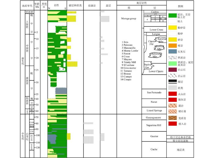
特立尼达盆地的北部边界为加勒比海与南美板块之间的连续分布的El Pilar断裂带,东部边界延伸至大西洋大陆架。盆地的南侧为东委内瑞拉盆地;西南以特立尼达和委内瑞拉国界线为盆地边界;西部边界以委内瑞拉东部赛若娜(Serrania)隆起东部的转换断层为界(图1)。盆地总面积27 336 km2,其中陆上面积3 861 km2,海上面积23 475 km2。盆地内发育白垩系、古近系和新近系地层,在特立尼达岛北部有侏罗系出露。盆地基底为侏罗系和白垩系变质岩及火成岩,盆地中烃源岩主要为上白垩统Albian-Campanian期的Gautier组和Naparima Hill组海相页岩和碳酸盐岩以及新近系泥岩。主要储层为上中新统—上新统地层的砂岩。上上新统Erin/Palmiste组(两组为同期沉积的相变地层)、下上新统Moruga群砂岩、第四系更新统Cedros组、渐新统Lower Cipero组、中新统Cipero组中的Karamat砂岩段-Herrera砂岩段是盆地内主要储集层(图2)。储层孔隙度为20%~36%,渗透率在不同储层差异较大,最低为50 md,最高为2 000 md[1]。
图1
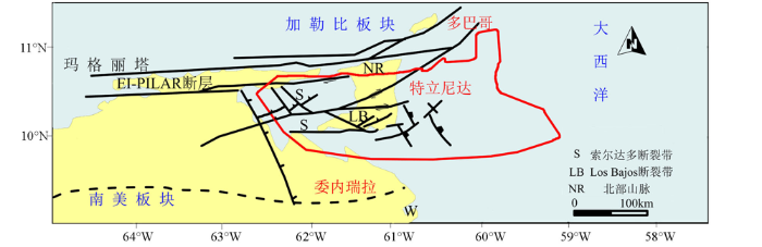
图2
2 重力场特征及地质意义
图3
图3
特立尼达盆地及邻区布格重力异常
Fig.3
Map of Bouguer gravity anomaly in Trinidad basin and its adjacent areas
为了研究盆地局部剩余重力异常特征,应用正则化滤波,滑动平均,解析延拓等方法对布格重力异常进行了分离[2,3],并结合已有地质、地震资料对比分析了上述几种位场分离方法的结果,发现滑动平均法求取的剩余重力异常与已有地质资料成果对应较好,因此,选用滑动平均法(窗口长70 km)求取了特立尼达盆地及邻区的剩余重力异常(图4)。可以看出, 在盆地北部剩余重力异常为一近EW向重力梯度带,对应北部边界处的EI-PILAR断裂带。剩余重力异常最大值位于特立尼达岛西侧的圭里亚附近,该高值带梯度较大、呈串珠状分布。盆地西部边界以委内瑞拉东部奥连特隆起的东部转换断层为界,西南以特立尼达和委内瑞拉国界线为盆地边界,其剩余重力异常反映为一NE向重力梯级带。盆地的东部边界处剩余重力异常为一近SN—NW向重力低。盆地内部剩余重力异常由北东向南西宏观反映为NW向的2个重力低值带夹1个重力高值带的特征。
图4
图4
特立尼达盆地及邻区剩余重力异常
Fig.4
Map of residual gravity anomaly in Trinidad Basin and its adjacent areas
3 断裂构造
图5
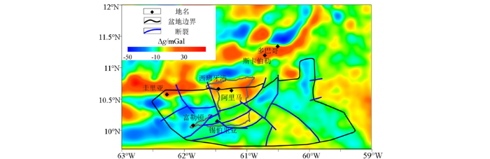
图5
特立尼达盆地剩余异常与断裂分布
Fig.5
Map of the fault distribution with residual gravity anomaly in Trinidad Basin
图6
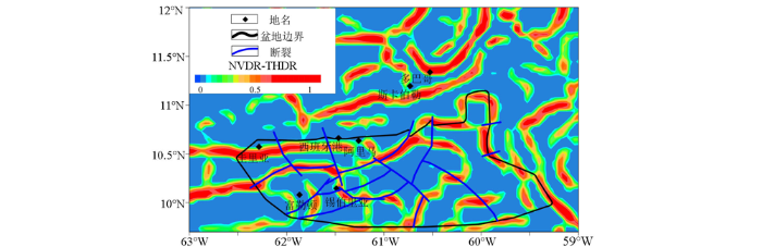
图6
特立尼达盆地NVDR-THDR与断裂分布
Fig.6
Map of the fault distribution with NVDR-THDR of Bouguer gravity anomaly in Trinidad Basin
图7
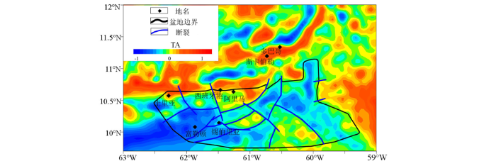
图7
特立尼达盆地斜导数与断裂分布
Fig.7
Map of the fault distribution with TA of Bouguer gravity anomaly in Trinidad Basin
4 基底特征
特立尼达盆地基底为侏罗纪和白垩纪的火成岩和变质沉积岩。Flinch等、Algar 等、Garciacaro等[5,6,7]利用地震测深确定了位于特立尼达盆地西部、特立尼达岛东部及盆地东部海域3条测线的基底深度,并解释了3条剖面(AA'、BB'、CC',剖面位置见图3)。为了确定整个盆地的基底深度,利用地震剖面解释的基底深度作为重力异常剖面拟合的约束条件,对与上述地震剖面位置相同的3条重力剖面进行了拟合,结果表明,计算所得的重力异常与实测重力异常吻合较好(图8~图10)。研究区大部分位于海域,密度资料缺乏,故同时利用上述重震拟合剖面,反演出了盆地内主要发育地层的密度,结果为:第四系密度约为(2.05~2.20)×103 kg/m3,新近系约为(2.10~2.35)×103 kg/m3,古近系约为(2.30~2.40)×103 kg/m3,白垩系约为2.58×103 kg/m3。
图8
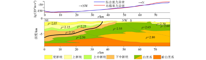
图8
AA'剖面重力异常拟合结果(密度单位为103 kg/m3)
Fig.8
2D interpreted and modelled of section AA' (the density unit is 103 kg/m3)
图9
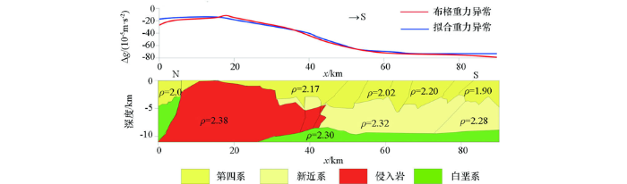
图9
BB'剖面拟合结果(密度单位为103 kg/m3)
Fig.9
2D interpreted and modelled of section BB'(the density unit is 103 kg/m3)
图10
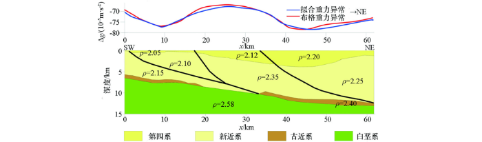
图10
CC'剖面拟合结果=2.38 (密度单位为103 kg/m3)
Fig.10
2D interpreted and modelled of section CC' (the density unit is 103 kg/m3)
图11

图12
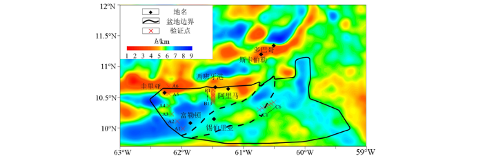
图12
盆地基底深度反演结果(Parker法)及验证点位置
Fig.12
Inverse result of basement depth in Trinidad basin by Parker method and location of verification points of inverse result
表1 Parker法反演结果与地震解释深度对比
Table 1
| 点号 | 地震解释深度/m | Parker法反演深度/m | 误差/m | 误差率/% |
|---|---|---|---|---|
| A1 | 3894 | 7851 | 3957 | 50.4 |
| A2 | 4108 | 6012 | 1905 | 31.7 |
| A3 | 3638 | 3461 | -177 | 5.1 |
| A4 | 3650 | 1407 | -2242 | 159.3 |
| A5 | 2810 | 2154 | -657 | 30.5 |
| A6 | 2258 | 1966 | -292 | 14.9 |
| B1 | 7930 | 1009 | -6921 | 685.7 |
| B2 | 7969 | 1638 | -6331 | 386.5 |
| B3 | 8081 | 4062 | -4018 | 98.9 |
| B4 | 8137 | 4443 | -3694 | 83.1 |
| B5 | 8192 | 4588 | -3604 | 78.5 |
| B6 | 8232 | 4734 | -3498 | 73.9 |
| B7 | 8264 | 4888 | -3376 | 69.1 |
| B8 | 8356 | 5208 | -3148 | 60.4 |
| B9 | 8458 | 5217 | -3241 | 62.1 |
| B10 | 8555 | 5080 | -3475 | 68.4 |
| B11 | 8641 | 5050 | -3591 | 71.1 |
| B12 | 8718 | 5368 | -3350 | 62.4 |
| B13 | 8786 | 6046 | -2739 | 45.3 |
| C1 | 9054 | 7513 | -1541 | 20.5 |
| C2 | 9059 | 7493 | -1566 | 20.9 |
| C3 | 8876 | 8144 | -732 | 9.0 |
| C4 | 8813 | 8797 | -16 | 0.2 |
| C5 | 8834 | 9362 | 528 | 5.6 |
| C6 | 8893 | 9860 | 967 | 9.8 |
| C7 | 9086 | 10414 | 1329 | 12.8 |
计算基底深度回归公式的确定是通过分别对比A、B区地震解释基底深度与不同窗口尺度位场分离得到的剩余异常、区域异常以及布格重力异常的相关性得出的,选取与地震解释深度相关性最高的剩余重力异常值,与地震解释深度进行回归分析,得到二者之间的函数关系,再将全区剩余重力值代入函数关系式,计算出基底深度。
对比后发现A区基底深度与使用滑动平均滤波方法(窗口直径70 km)求取的剩余场相关性最好(R2=0.713),双侧显著性为0。回归分析结果显示,6次函数拟合效果最好(R2=0.993),基底深度H=-7.921404726×10⁻⁷Δg6 -3.130398376×10⁻⁵Δg5 -0.0002175962005Δg4+0.004240172887Δg3+0.05845750911Δg2+0.4021498138Δg-2.576221587[16]。
图13
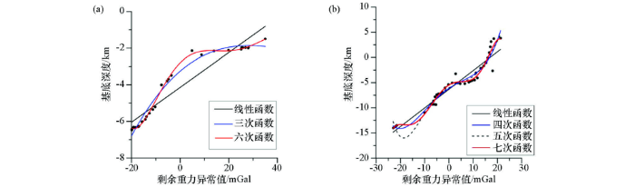
图13
A区(a)和B区(b)剩余重力异常与地震解释深度回归分析结果
Fig.13
Regression analysis results of residual gravity anomaly and seismic interpretation depth in areas A(a) and B(b)
图14
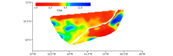
表2 相关分析法计算结果与地震解释深度对比
Table 2
| 点号 | 地震解释深度/m | 相关分析法计算深度/m | 误差/m | 误差率/% |
|---|---|---|---|---|
| A1 | 6170 | 7851 | 1681 | 21.4 |
| A2 | 6072 | 6012 | -59 | 1.0 |
| A3 | 3252 | 3461 | 209 | 6.0 |
| A4 | 1350 | 1407 | 58 | 4.1 |
| A5 | 2213 | 2154 | -59 | 2.7 |
| B1 | 783 | 1009 | 226 | 22.4 |
| B2 | 1706 | 1638 | -68 | 4.2 |
| B3 | 3517 | 4062 | 546 | 13.4 |
| B4 | 4037 | 4443 | 406 | 9.1 |
| B5 | 4363 | 4588 | 226 | 4.9 |
| B6 | 4497 | 4734 | 237 | 5.0 |
| B7 | 4607 | 4888 | 281 | 5.8 |
| B8 | 4744 | 5208 | 465 | 8.9 |
| B9 | 4806 | 5217 | 411 | 7.9 |
| B10 | 4916 | 5080 | 164 | 3.2 |
| B11 | 5150 | 5050 | -101 | 2.0 |
| B12 | 5530 | 5368 | -163 | 3.0 |
| B13 | 6025 | 6046 | 21 | 0.4 |
综合A、B区使用相关分析法计算得到的基底深度和C区使用Parker法的计算结果,得到特立尼达盆地基底深度(图15)。此处需要说明的是A、B、C这3个区域均以断裂为界,因此,3个区域接边处基底深度的差异主要反映了断层断距。
图15
由图15可以看出,特立尼达盆地基底深度在特立尼达岛上部分埋深相对较浅,特立尼达岛东部的海上部分埋深较深,盆地西部Paria湾区基底起伏明显,在特立尼达岛北部近EI-PILAR断裂带处有侏罗系地层露头。特立尼达盆地西北部剩余异常高值带的基底深度在3.5~7.5 km之间,盆地中部重力高—低值转换带的基底深度在5.5~11.5 km之间,盆地东南部重力低值带的基底埋深在6~11.4 km之间。
5 构造单元划分及油气远景
目前,对特立尼达盆地构造单元划分的相关文献和研究成果较少。本研究分析了由重力场特征推测得到的研究区断裂构造分布,以及利用不同方法计算所得的基底深度,结合地质资料,对特立尼达盆地的构造单元进行了划分。
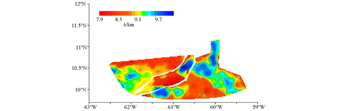
特立尼达盆地东部及西部基底埋深较深,盆地中部及西北部基底埋深较浅,据此,把盆地划分为东部次盆、中部隆起,西部次盆、西北部凸起5个次级构造单元(图16)。
图16
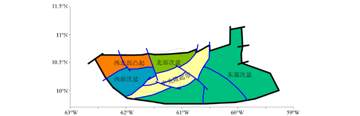
图16
特立尼达盆地次级构造单元划分示意
Fig.16
Sketch map of the division of secondary structural units in the Trinidad Basin
特立尼达盆地发育上白垩统海相烃源岩及高孔高渗储层,具有良好的储盖组合,为盆地形成大规模的油气聚集提供了基础。
据盆地基底深度及盆内构造单元,研究区西部次盆和位于研究区东部次盆为大面积凹陷,沉积厚度较大,基底埋深在3 500~7 000 m之间,根据已有的地质资料显示,上述两个构造单元内烃源岩较为发育,储集层物性优良,盖层封闭性较好,应为特立尼达盆地油气远景区(图17)。北部次盆南部基底埋深约为4 000 m,新生界发育,也值得进一步关注。
图17
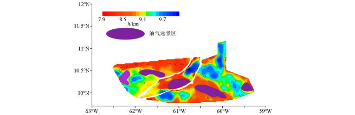
图17
特立尼达盆地基底深度计算结果与油气远景区叠合
Fig.17
Overlay of basement depth calculation results and oil&gas prospects in the Trinidad Basin
6 结论
1)特立尼达盆地断裂发育,主要断裂走向为NE向,控制了盆地边界和盆地内部构造单元的边界,次要断裂走向为NW向,属于沉积层内断裂,控制了盆地内凹陷和凸起的边界。
2)特立尼达盆地总体上为东西部基底深度大、中部基底深度小,特立尼达盆地可划分为东部次盆、中央隆起带、北部次盆、西部次盆次盆和西北部凸起等5个次级构造单元。
3)特立尼达盆地基底起伏较大。北部近EI-PILAR断裂带处有侏罗系基底出露,盆地中部的特立尼达岛陆上区域断裂发育,基底埋深较浅。盆地东部及西部的基底埋深大,新生界地层厚度大,应为特立尼达盆地油气勘探的有利区,盆地北部部分区域基底埋深相对较大,也值得进一步关注。
参考文献
Energy and its affiliated and subsidiary companies
[R].
边界识别技术及其在虎林盆地中的应用
[J].
Boundary detection method and its application in Hulin Basin
[J].
重磁位场分离及边界识别方法研究
[D].
Study on the separation of gravity and magnetic potential field and Boundary recognition method
[D].
Chapter 17 Structure of the Gulf of paria pull-apart basin (Eastern Venezuela-Trinidad)
[J].
Structure and deformation history of the northern range of Trinidad and adjacent areas
[J].DOI:10.1029/93TC00673 URL [本文引用: 2]
Regional structure and tectonic history of the obliquely colliding Columbus foreland basin, offshore Trinidad and Venezuela
[J].
The inversion and interpretation of gravity anomalies
[J].DOI:10.1190/1.1440444 URL [本文引用: 1]
Best bounds on density and depth from gravity data
[J].DOI:10.1190/1.1440454 URL [本文引用: 1]
Parker公式的一系列推广及其在石油重力勘探中的应用前景
[J].
Parker’s fomulas in different forms and their applications to oil gravity survey
[J].
三维密度界面的正反演研究和应用
[J].
The investigation and application of three-dimensional density interface
[J].
渭河盆地基底三维变密度重力反演
[J].
Basement depth estimation based on gravity anomalies in Weihe Basin with 3D variable density contrast model
[J].
高精度重力资料的密度界面反演
[J].
The density interface inversion of high-precision gravity data
[J].
Gravity and magnetic field characteristics and hydrocarbon prospects of the Tobago Basin
[J].DOI:10.1111/gpr.2018.66.issue-8 URL [本文引用: 1]
利用重力资料研究穆格莱德盆地南部新生界分布
[J].
The study of the distribution of Cenozoic in the southern Muglad Basin based on gravity data
[J].
SPSS statistical analysis essentials and detailed explanation of examples
[D].
Evolution of southern Caribbean Plate boundary, vicinity of Trinidad and Tobago
[J].
