

0 引言
土壤作为陆地生态系统的重要组成部分,在物质和能量循环方面起着至关重要的作用。土壤作为城市绿地生态环境的物质基础,是城市污染物的汇集地,对城市污染物具有缓冲和净化作用。城区内强烈的人类活动、工业生产废弃物以及大气沉降等均会向土壤中排放重金属污染物[1],由于重金属污染物难于降解,长期排放量超过土壤的承载能力,造成重金属在土壤中富集。受生物累积作用的影响,重金属污染的土壤将直接威胁陆地生态系统的安全,尤其是处于食物链顶端的人类[2]。城市边缘区土壤不仅需要承载城区远距离迁移输入地外源性重金属污染物[3],还叠加了城市边缘区自身越来越强烈的人类生活和工业生产产生的重金属排放,致使城市边缘区土壤重金属污染加剧恶化,严重影响了城市可持续发展和人民群众的身心健康,其生态环境风险问题不容忽视,日益引起学者关注[4,5,6,7,8,9,10,11,12]。
黄石市作为湖北省经济总量第二的资源型城市,素以金属矿产闻名,市区范围内有色金属和黑色金属等高耗能、高污染企业较多。研究表明黄石市区的大气降尘重金属含量严重超标,其中以Cu、Zn、As、Pb和Cd污染最为突出[13,14]。在黄石市区内的水体、湖底沉积物、土壤和蔬菜中发现了Cr、Ni、Cd、Cu、Pb、As和Zn重金属污染,其中Cr是最主要的致癌因子[15,16,17,18]。由此可见,黄石市区内重金属污染存在于多种环境介质中。近年来,随着黄石市城市化进程的加快和经济的快速发展,城区开发边界逐渐扩展到城市边缘区,高污染企业逐渐向城市边缘区迁移,但由于多种土地利用形式并存、人类活动多样化以及污染源多元化等条件的限制,现阶段对黄石市城市边缘区土壤中重金属污染特征、污染来源以及生态风险等基本问题尚缺乏足够的认识。本研究以黄石市经济开发区为研究对象,通过高密度土壤样品采集分析,试图阐述黄石市城市边缘区土壤中重金属污染特征,厘定污染物的主要源区及其贡献,并评估其生态环境风险状况。本文不仅为城市边缘区土壤重金属污染研究提供研究思路,也为当地环境保护部门提供了基础环境调查数据,旨在保障人民群众的“菜篮子”和“粮仓”的食品安全。
1 材料与方法
1.1 样品采集
黄石市位于鄂东南,地势西南高,东北低,由西南向东北倾斜;属亚热带季风气候,四季分明,雨量充沛。研究区位于黄石市经济开发区,大王山—九两山南侧,大冶湖北侧。根据1∶25万《湖北省鄂州—黄石经济带多目标地球化学调查》项目中黄石市表层土壤重金属元素空间分布规律,按照土地性质选取15个研究地块,分别为旱地地块D1~D5,林地地块F1~F3,水稻田地块P1~P7,其中水稻田为水旱轮作地。选取其中2个水稻田地块P6和P7为重点研究区,进行纵剖面研究。研究区区域位置和采样点详细分布如图1所示。
图1
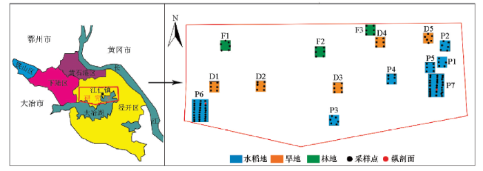
一般研究区的每个地块面积为6 000 m2,按照200 m×100 m网格布设采样点6个;重点研究区每个地块面积10 000 m2,按照100 m×40 m网格布设采样点30个。根据每个地块布置的采样点位置,同点采集0~20 cm表层土壤样品和20~40 cm深层土壤样品,另外在2个重点研究区布置1 m纵深土壤剖面;按照10 cm/样采集。按照不低于总样品数的10%,共采集30件重复样品。为提高每个采样点上样品的代表性,样品为多点组合,采样时应在采样点附近3~5处分别采集。
1.2 样品处理与分析方法
在野外用竹铲剔除与金属采样器接触的部分土壤。样品经自然风干后,挑出根系、秸秆、石块、虫体等杂物。将各分样品充分混匀后合并成一个样品,采用四分法留取0.5~1.0 kg样品。经玛瑙研磨后过200目(0.075 mm)筛,装入样品袋中送实验室测试。
pH值采用pHSJ-4f型酸度计测定,分析方法及检出限执行NY/T 1377—2007标准。Cu、Cd、Cr、Pb、Zn和Ni总量采用M90型电感耦合等离子体质谱仪分析,分析方法及检出限执行HJ 803—2016标准;As和Hg总量采用AFS3000型氰化物发生—原子荧光光度计分析,分析方法及检出限执行GB/T 22105.1—2008和GB/T 22105.2—2008标准。本次测试工作通过外部监控和内部监控来控制分析质量。按照《农田土壤环境质量检测技术规范》(NY/T 395—2012)的要求,本批次样品共测试盲样样品19件,重复样40件;盲样样品所有检测项目均控制在合格范围内,合格率100%,重复样样品所有检测项目合格率均大于90%。
1.3 统计分析与环境风险评价方法
数据统计分析采用SPSS17.0和EXCEL2019软件。相关分析计算Pearson相关系数,系统聚类分析采用Pearson相关性进行聚类,主成分分析采用相关性矩阵提取3个主因子。除特殊申明外,本文数据分析均采用实验室测试的重金属元素原始含量数据,而非标准化数据。
式中:Cn为污染物的实测浓度;Bn为污染物的地球化学背景值,本研究的区域背景值是依据《湖北省鄂州—黄石沿江经济带多目标区域地球化学调查》项目报告中950件土壤样品计算所得;K是考虑自然成岩作用所引起背景值变动而选取的系数,通常情况下为1.5[23]。
2 结果与分析
2.1 土壤重金属含量
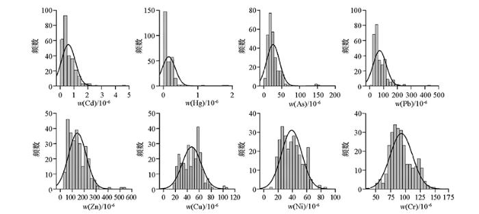
从表1可知,研究区土壤pH值范围为4.90~8.41,少部分处于强酸性状态,但从平均值6.72~7.26和中位数7.19来看,土壤整体处于中性。研究区土壤中的重金属元素As、Pb、Hg、Cd、Zn、Ni、Cu和Cr含量范围分别为(5.2~155.9)×10-6 、(19.2~426.1)×10-6 、(0.012~1.823)×10-6 、(0.03~4.59)×10-6 、(34.8~529.6)×10-6 、(8.5~86.2)×10-6 、(16.52~104.39)×10-6 和(51.2~145.5)×10-6,变异系数为0.19~1.24,其中Hg(1.24)的变异系数最高,As、Pb和Cd次之(>0.60),Zn为0.50,Ni、Cu和Cr较低(<0.40)。对研究区土壤重金属元素含量进行单样本K-S正态分布假设检验,发现Hg、As、Pb和Cd的概率均为0,小于显著性水平0.050,呈正偏非正态分布。进一步进行对数正态分布假设检验,Hg、As、Pb和Cd的概率分别为0.076、0.950、0.143和0.469,且高于显著性水平0.050,因此判断这些元素服从对数正态分布,含有部分高值异常点;而Cu和Ni的概率为0.247、0.062,均大于显著性水平0.050,呈正态分布(图2)。表层土壤样本和深层土壤样本与总体样本相似,Hg、As、Pb和Cd呈对数正态分布,Cu和Ni呈正态分布。虽然在总样本中Zn(0.039)和Cr(0.023)呈对数正态分布,但是在表层土壤样本和深层土壤样本中Zn(0.265和0.130)和Cr(0.059和0.099)呈显著的正态分布。概率分布规律和变异系数说明Hg、As、Pb和Cd在土壤中的分布不均一,其分布受到明显的人为因素干扰,而Cu、Ni、Cr和Zn分布较均一,其分布主要受母岩自然风化控制。
表1 研究区土壤样品重金属描述性统计数据
Table 1
| 参数 | pH | As | Pb | Hg | Cd | Zn | Ni | Cu | Cr | |
|---|---|---|---|---|---|---|---|---|---|---|
| 平均值 | 水田(N=180) | 7.26 | 26.7 | 70.7 | 0.170 | 0.55 | 152.9 | 42.6 | 51.99 | 96.4 |
| 旱地(N=60) | 6.90 | 25.5 | 84.5 | 0.136 | 0.76 | 131.9 | 32.4 | 38.80 | 83.7 | |
| 林地(N=36) | 6.72 | 21.6 | 56.9 | 0.106 | 0.48 | 112.1 | 32.2 | 37.82 | 89.0 | |
| 富集系数 | 水田(N=180) | 2.94 | 2.70 | 4.15 | 5.02 | 2.08 | 1.36 | 1.76 | 1.30 | |
| 旱地(N=60) | 2.81 | 3.22 | 3.32 | 6.95 | 1.79 | 1.04 | 1.32 | 1.13 | ||
| 林地(N=36) | 2.38 | 2.17 | 2.58 | 4.32 | 1.52 | 1.03 | 1.28 | 1.20 | ||
| 最大值 | 8.41 | 155.9 | 426.1 | 1.823 | 4.59 | 529.6 | 86.2 | 104.39 | 145.5 | |
| 最小值 | 4.90 | 5.2 | 19.2 | 0.012 | 0.03 | 34.8 | 8.5 | 16.52 | 51.2 | |
| 中位数 | 7.19 | 21.4 | 57.3 | 0.090 | 0.43 | 136.0 | 38.3 | 48.80 | 90.0 | |
| 变异系数 | 0.10 | 0.70 | 0.66 | 1.24 | 0.86 | 0.52 | 0.36 | 0.34 | 0.19 | |
| 区域背景值 | 6.87 | 9.1 | 26.2 | 0.041 | 0.11 | 73.6 | 31.2 | 29.5 | 74.2 | |
| 风险筛选值 | 水田 | 25 | 120 | 0.6 | 0.3 | 250 | 100 | 100 | 200 | |
| 其他 | 30 | 2.4 | ||||||||
注:元素含量单位为10-6;平均值按照土地使用性质分为水田、旱地和林地,包括表层土壤和深层土壤;最大值、最小值、中位数以及变异系数按照所有样品进行统计计算;区域背景值依据“湖北省鄂州—黄石沿江经济带多目标区域地球化学调查”项目报告中950件土壤样品计算所得;风险筛选值采用《土壤环境质量 农用地土壤污染风险管控标准(试行)》(GB 15618—2018)中6.5<pH≤7.5的值,对于水旱轮作地,采用其中较严格的风险筛选值。
图2
同区域土壤环境背景值相比,水田和旱地土壤中重金属平均含量均超过背景值,其中水田以As、Pb、Hg、Cd、Zn、Ni、Cu和Cr富集较明显,旱地以As、Pb、Hg和Cd富集较明显。虽然林地土壤受人类活动影响较小,但各重金属含量平均值也超过区域土壤环境背景值,总体上As、Pb、Hg和Cd的富集程度小于水田和旱地,Zn、Ni、Cu和Cr的富集程度小于水田,与旱地相当。由于研究区土壤整体处于中性范围,因此表1中风险筛选值采用《土壤环境质量 农用地土壤污染风险管控标准(试行)》(GB 15618—2018)中6.5<pH≤7.5的值。对于水旱轮作地,采用其中较严格的风险筛选值。从表1平均值可知,水田中As和Cd,旱地和林地中Cd均超过农用地土壤污染风险筛选标准。从超标率来看,所有土壤中超标率排序为Cd>As>Pb>Zn>Hg。水田中As、Cd和Pb的超标率分别为46%、68%和7%;旱地中As、Cd和Pb的超标率分别为37%、67%和8%;林地中As、Cd和Pb的超标率分别为25%、53%和14%。
2.2 土壤重金属垂直分布特征
为了更好地认识研究区土壤中重金属的分布特征,对比分析了同点位的表层土壤(0~20 cm)和深层土壤(20~40 cm)中的重金属元素含量。为方便比较和统一化原始数据的量纲,按照下列标准化规则对原始重金属含量数据进行标准化处理:
图3
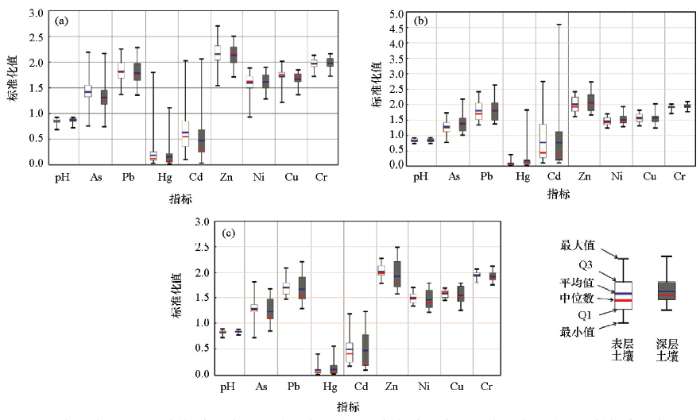
图3
深层土壤与表层土壤中pH和各重金属对比
a—水田(表层和深层土壤样品各90件);b—旱地(表层和深层土壤样品各30件);c—林地(表层和深层土壤样品各18件)
Fig.3
Comparison of pH and heavy metals content between the topsoil and the deepsoil
a—paddy land (surface and deep soil samples each 90);b—dry land (topsoil and deepsoil samples each 30);c— forest land (surface and deep soil samples each 18)
由于水旱轮作的特点,水田土壤中的氧化还原环境相对不稳定,其中的重金属元素的迁移转化规律复杂多变;其次研究区典型重金属污染物主要分布在水田中;因此我们进一步选取水田地块中P6地块6号采样点和P7地块23号采样点作为重点研究点,分析了土壤重金属元素垂直剖面分布情况。从图4所示剖面中不难看出,重金属污染物主要分布在40 cm以上,Hg、As和Pb含量高于区域背景值而低于风险筛选值,而Cd含量却远高于背景值,甚至高于风险筛选值。但40 cm以下重金属含量快速下降,90 cm~1 m后逐渐接近区域背景值。Zn、Cu、Ni和Cr在70 cm以上土壤中含量基本保持一致,均高于区域背景值而低于风险筛选值,但在70 cm以下深度含量开始下降,同样在90 cm~1 m后逐渐恢复到区域背景值附近。剖面中所有重金属含量均高于区域背景值的结果说明了研究区具有较高的重金属背景值,这与研究区的区域铜铁矿床富集有关,因为重金属元素常伴生于黄铜矿、黄铁矿、磁黄铁矿、辉钼矿等硫化物矿物中。因此,在进行研究区的重金属污染风险评价过程中不可忽视研究区高背景值对重金属元素含量的影响。
图4
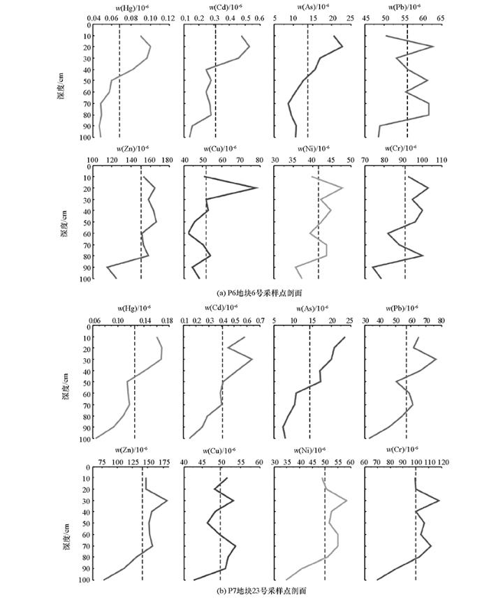
图4
水田重金属元素含量(图中虚线表示在该剖面中重金属元素平均含量)
Fig.4
Heavy metals content profiles in paddy land(the dotted line denoted average content in this profile)
2.3 重金属污染生态环境风险评价
以鄂州—黄石区域环境地球化学背景值为标准,计算研究区表层土壤8种重金属的地累积指数(表2)。从平均地累积指数来看,研究区表层土壤地累积指数大小依次为:Cd>Hg>As>Pb>Zn>Cu>Cr>Ni。从污染范围和污染程度来看,几乎所有的表层土壤都存在不同程度Cd污染,其中71.7%在中度污染以上,9.4%处于强—较强污染程度;Hg污染的表层土壤占比为75.4%,主要集中处于轻度—中强污染程度(73.9%),但有2个采样点位受到了强—较强污染;As污染的表层土壤占比为85%,主要处于轻度—中度污染程度(81.9%);Pb污染的表层土壤占比为79%,主要为轻度—中度污染;Cu和Zn污染的土壤占比分别为61.6%和63.7%,且主要为轻度污染,少部分为中度污染;而Cr和Ni污染的土壤占比最低,分别为15.9%和28.3%,基本为无污染—轻度污染。对比不同土地类型表层土壤重金属平均地累积指数不难发现(表3),水田中As、Pb、Cu和Zn为轻度污染,Cd和Hg为中度污染而Cr和Ni无污染;旱地和林地中As、Pb和Hg为轻度污染,Cd为中度污染而Cr、Cu、Ni和Zn无污染。上述研究区表层土壤中重金属污染程度明显高于全国和湖北省农田土壤平均水平,但主要重金属污染元素相同[24]。虽然As、Pb、Cu、Zn、Cd和Hg存在不同程度的轻—中度污染,但前人研究表明黄石市的农业土壤中重金属化学形态分布以稳定的残渣态为主[25,26],不易迁移转化,其生物毒性也较小。
表2 研究区表层土壤重金属地累积指数统计
Table 2
| 元素 | ≤0 | 0~1 | 1~2 | 2~3 | 3~4 | 4~5 | 平均值 | 中位数 | 最小值 | 最大值 |
|---|---|---|---|---|---|---|---|---|---|---|
| 无污染 | 轻度污染 | 中度污染 | 中强污染 | 强污染 | 较强污染 | |||||
| As | 20(14.5) | 67(48.6) | 46(33.3) | 4(2.9) | 1(0.7) | 0.78 | 0.77 | -1.40 | 3.51 | |
| Cd | 7(5.1) | 31(22.5) | 50(36.2) | 37(26.8) | 12(8.7) | 1(0.7) | 1.64 | 1.66 | -0.66 | 4.05 |
| Cr | 116(84.1) | 22(15.9) | -0.30 | -0.30 | -1.12 | 0.28 | ||||
| Pb | 29(21.0) | 63(45.6) | 39(28.3) | 7(5.1) | 0.68 | 0.58 | -0.86 | 2.71 | ||
| Cu | 53(38.4) | 84(60.9) | 1(0.7) | 0.07 | 0.21 | -1.42 | 1.23 | |||
| Hg | 34(24.6) | 49(35.5) | 26(18.8) | 27(19.6) | 1(0.7) | 1(0.7) | 0.81 | 0.72 | -2.36 | 4.87 |
| Ni | 99(71.7) | 39(28.3) | -0.38 | -0.29 | -2.46 | 0.70 | ||||
| Zn | 50(36.2) | 69(50.0) | 18(13.0) | 1(0.7) | 0.20 | 0.33 | -1.67 | 2.19 |
注:表中分级标准依据文献[
表3 不同土地类型表层土壤重金属平均地累积指数对比
Table 3
| Igeo | As | Cd | Cr | Pb | Cu | Hg | Ni | Zn |
|---|---|---|---|---|---|---|---|---|
| 水田 | 0.94 | 1.69 | -0.25 | 0.75 | 0.25 | 1.19 | -0.24 | 0.36 |
| 旱地 | 0.48 | 1.68 | -0.44 | 0.68 | -0.30 | 0.04 | -0.71 | -0.12 |
| 林地 | 0.47 | 1.30 | -0.31 | 0.34 | -0.24 | 0.17 | -0.57 | -0.08 |
| 表层土壤 | 0.78 | 1.64 | -0.30 | 0.68 | 0.07 | 0.81 | -0.38 | 0.20 |
2.4 重金属污染源解析
多元统计分析主要用于从数量庞大、类型众多的样品数据中发现变量背后的相互关系和统计规律,已经广泛应用于土壤重金属污染源的识别,其中的相关分析、聚类分析以及主成分分析是识别土壤重金属自然源和人为源的主要方法。相关分析和聚类分析主要用以衡量重金属元素间的相关密切程度。主成分分析是将若干个主成分线性组合为各重金属元素含量。通常认为相关性高的元素组合具有同源性,因此,利用不同多元统计分析方法获得的元素组合信息,结合区域地球化学环境背景和人类活动特征可以对土壤重金属污染源进行多方位的解析。
土壤中重金属的来源分为自然源和人为污染源,其中人为污染源主要来源于工业生产活动、交通运输、煤炭燃烧、污水灌溉以及化肥农药使用等。表4为研究区各土壤重金属元素之间的相关关系情况。从表中可见,Ni与Cr呈显著正相关,As与Hg呈显著正相关,Cd和Pb呈显著正相关, Zn与Cd、Pb、Hg和Ni均为显著正相关, Cu与Ni、Zn呈中等正相关。聚类分析显示8种重金属元素共聚为3类元素组合,分别为Cd和Pb,Ni、Zn、Cu和Cr,以及As和Hg,该聚类结果与相关性分析结果一致(图5)。表5为对研究区土壤中8种重金属进行主成分分析的结果。提取前3个主成分,累积贡献率达到86%,可以反映原始数据的绝大部分信息。第一主成分(PC1)具有较高载荷的元素为Cr、Ni、Cu和Zn,第二主成分(PC2)具有较高载荷的元素为Cd和Pb,第三主成分(PC3)具有较高载荷的元素为As和Hg。结合上述3种多元统计分析结果可知,Cr、Ni、Cu和Zn为同一污染源,Cd和Pb为一污染源,而As和Hg为另一污染源。通过对土壤母质分析后认为,土壤中的Ni和Cr可能来源于土壤母质和地球化学活动,而Pb、Hg和Cd等重金属元素的分布则多与人为活动因素相关[27,28,29,30,31]。因此,笔者推断Cr和Ni来自于成土母质,主要受到元素地球化学性质和环境因素控制。Cr和Ni含量具有相对较低的空间变异系数以及服从正态分布的结果同样支持其自然来源的推论。结合Cu和Zn含量的中等空间分异特征和部分采样点位的轻度污染情况,虽然Cu和Zn与Cr和Ni具有高度正相关关系,但是Cu和Zn为混合源,主要来源于岩石的风化和土壤母质,同时叠加了部分人类活动和工业生产的重金属排放特征。考虑到黄石市为工矿业生产大市,矿产开采、金属冶炼加工企业较多,推断Cd和Pb、As和Hg主要为人为源,来源于黄石市工矿业生产活动的无组织粉尘和烟气排放、开采过程中硫化物矿物中重金属元素的活化释放。该推断与这些重金属元素的空间高分异性以及呈对数正态分布的规律一致。
表4 研究区土壤重金属含量之间的Pearson相关系数矩阵(n=276)
Table 4
| 元素 | As | Cd | Cr | Pb | Cu | Hg | Ni | Zn |
|---|---|---|---|---|---|---|---|---|
| As | 1 | |||||||
| Cd | 0.388 | 1 | ||||||
| Cr | 0.331 | 0.356 | 1 | |||||
| Pb | 0.444 | 0.907** | 0.400 | 1 | ||||
| Cu | 0.468 | 0.337 | 0.326 | 0.282 | 1 | |||
| Hg | 0.877* | 0.348 | 0.338 | 0.390 | 0.468 | 1 | ||
| Ni | 0.507 | 0.539 | 0.721* | 0.542 | 0.662 | 0.577 | 1 | |
| Zn | 0.672 | 0.736* | 0.571 | 0.724* | 0.649 | 0.717* | 0.883* | 1 |
注:“*”表示在0.01水平(双侧)上,相关系数>0.700或<-0.700则显著相关。
图5
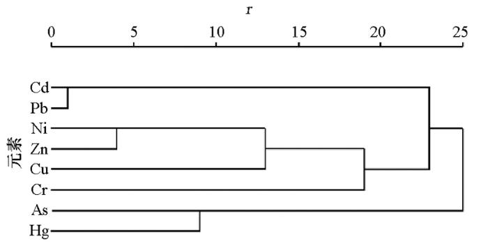
图5
研究区土壤重金属聚类树状图(n=276)
Fig.5
Hierarchical clustering of heavy metals in study area soil (n=276)
表5 研究区土壤重金属主成分分析旋转成分矩阵(n=276)
Table 5
| 元素 | PC1 | PC2 | PC3 |
|---|---|---|---|
| Cr | 0.858 | 0.180 | 0.034 |
| Ni | 0.857 | 0.297 | 0.312 |
| Cu | 0.635 | 0.110 | 0.458 |
| Zn | 0.606 | 0.574 | 0.490 |
| Cd | 0.200 | 0.948 | 0.158 |
| Pb | 0.228 | 0.934 | 0.195 |
| Hg | 0.186 | 0.138 | 0.913 |
| As | 0.203 | 0.236 | 0.848 |
| 方差/% | 30.101 | 28.850 | 27.041 |
| 累积方差/% | 30.101 | 58.951 | 85.992 |
3 结论
1) 研究区土壤中所有重金属的平均含量均超过区域背景值,并且Cd还超过了《土壤环境质量 农用地土壤污染风险管控标准(试行)》(GB15618—2018)规定的风险筛选值,水田中的As同样超过风险筛选值。超标率表明,研究区土壤中以Cd、As和Pb为主要特征污染物。
2) 总体上,研究区表层土壤重金属元素含量高于深层土壤,土地类型水田和旱地污染风险大于林地。垂直剖面研究表明重金属污染物主要集中在表层40 cm以上土壤中。由于研究区处于沿长江区域铜铁矿床成矿带,土壤重金属元素背景值高于区域土壤环境背景值。
3) 生态风险评价表明,研究区土壤中的最主要污染物为Cd,污染程度达中度污染,污染范围涵盖研究区所有土壤类型;As、Pb、Hg、Cu和Zn在不同类型土壤中呈现轻度—中度不同程度的污染,而Cr和Ni在研究区土壤中几乎全部处于无污染现状。
4) 相关分析、聚类分析以及主成分分析结果均表明,研究区土壤中Cr和Ni为自然源成因,Cd和Pb、As和Hg主要为人为源污染,而Cu和Zn为混合源成因。
致谢:
感谢中国地质大学(武汉)地球科学学院李方林教授在本文写作过程中提出的意见和建议。
参考文献
A review of heavy metal pollution levels and health risk assessment of urban soils in Chinese cities
[J].DOI:10.1007/s11356-017-0513-1 URL [本文引用: 1]
Heavy metal burdens of public primary school children related to playground soils and classroom dusts in Ibadan North-West local government area, Nigeria
[J].
DOI:S1382-6689(16)30294-0
PMID:27889649
[本文引用: 1]

Information about heavy metal burden of children in Nigeria related to playground soils and classroom dusts is lacking. Playground soil, classroom dust, blood and spot urine samples (n=253) were collected from 6 urban and 2 semi-rural public schools in Ibadan North-West, Nigeria. Samples were analysed for Pb, Cu, Zn, Fe and Mn. Mean blood Pb levels in urban area (male, 41.66±8.78μg/dl vs. female, 40.64±5.46μg/dl) were twice as high as those in semi-rural area (male, 19.71±3.73μg/dl vs. female, 20.65±2.26μg/dl). Concentrations of Pb, Cu, Zn, and Fe in soil and dust samples in the urban schools were between 2- to 4-fold greater than that of semi-rural schools. No correlation was observed between blood and dust metals. A positive correlation (r=0.168, p=0.008) was observed between blood Pb and playground soil Pb. Pb burden in the children might be from their schools' playgrounds and other yet unidentified sources.Copyright © 2016 Elsevier B.V. All rights reserved.
Characteristics of particulate-bound mercury at typical sites situated on dust transport paths in China
[J].DOI:10.1016/j.scitotenv.2018.08.137 URL [本文引用: 2]
Environmental geochemical mapping and multivariate geostatistical analysis of heavy metals in topsoils of a closed steel smelter: Capital Iron & Steel Factory, Beijing, China
[J].DOI:10.1016/j.gexplo.2013.02.010 URL [本文引用: 2]
Source identification and ecological risk assessment of heavy metals in topsoil using environmental geochemical mapping: Typical urban renewal area in Beijing, China
[J].DOI:10.1016/j.gexplo.2013.10.002 URL [本文引用: 1]
Geostatistical mapping and quantitative source apportionment of potentially toxic elements in top-and sub-soils: A case of suburban area in Beijing, China
[J].DOI:10.1016/j.ecolind.2020.106085 URL [本文引用: 1]
Source identification of potentially hazardous elements and their relationships with soil properties in agricultural soil of the Pinggu district of Beijing, China: Multivariate statistical analysis and redundancy analysis
[J].DOI:10.1016/j.gexplo.2016.12.006 URL [本文引用: 1]
Geo-statistical and multivariate analyses of potentially toxic elements’ distribution in the soil of Hainan Island (China): A comparison between the topsoil and subsoil at a regional scale
[J].DOI:10.1016/j.gexplo.2018.11.008 URL [本文引用: 1]
长沙市边缘带菜园土壤重金属含量及污染现状评价
[J].
Assessment on contents of heavy metal and its pollution situation in vegetable soils at peri-urban area of Changsha
[J].
城市边缘区土壤重金属污染及其生态环境效应研究进展
[J].
Research progress of heavy metal pollution and its eco-environmental effect in the urban fringe area
[J].
芜湖市城市边缘区土壤重金属污染空间特征研究
[J].
DOI:10.13249/j.cnki.sgs.2008.02.282
[本文引用: 1]
通过对安徽省芜湖市城市边缘区14个典型土壤采样点重金属As、Hg、Pb、Cd、Zn、Cr污染现状的调查与分析,以本地区自然土壤中重金属元素自然含量的平均值作为评价标准,分别计算出各调查区土壤单因子污染指数,应用对应分析技术,初步研究了芜湖市城市边缘区土壤重金属污染的空间分异特征。结果表明,芜湖城市边缘区土壤重金属污染已相当显著,且各区域间土壤重金属污染水平具有明显的差异。总体上看,鸠江、马塘、西江等样点较其他区域污染严重,各区域间Pb、Hg污染水平差异明显,但As、Cd、Zn、Cr污染水平差异不大。
Heavy metal pollution in soils of peri-urban zone of Wuhu city
[J].
上海城郊土壤重金属含量的空间变异与分布特征——以上海市闵行区为例
[J].
Spatial variability and distribution of soil heavy metals content in suburbs of Shanghai — A case study of Minhang Shanghai city
[J].
黄石市大气PM 10和 PM 2.5中元素特征及重金属生态风险评价
[J].
Characteristics of elements and ecological risk assessment of heavy metals in PM 10 and PM 2.5 in Huangshi
[J].
黄石市大气降尘中重金属污染特征与评价
[J].
Distribution characteristics and risk assessment of heavy metals in atmosphere dustfall of Huangshi city, China
[J].
黄石市某钢铁厂周边苔藓植物重金属含量研究及污染评价
[J].
Research on content of heavy metals in moss around a steel mill and its pollution assessment in Huangshi city
[J].
有色金属冶炼厂周边地表水和农业土壤中重金属污染特征与评价
[J].
Pollution characteristics and health risk assessment of heavy metals in surface water and agricultural soil around the Nonferrous Metal Smeltery
[J].
黄石市青山湖底泥重金属污染评价分析
[J].
Analysis and assessment on heavy metal pollution in bottom mud of Qingshan Lake in Huangshi city
[J].
黄石废弃采石场人工植被修复后重金属含量特征及污染评价
[J].
Distribution and pollution assessment of heavy metals in soils after artificial vegetation restoration in abandoned quarries in Huangshi
[J].
富集因子在环境地球化学重金属污染评价中的应用
[J].
Application of enrichment factor in evaluation of heavy metals contamination in the environmental geochemistry
[J].
黑龙江生态省土壤重金属分布特征及其生态风险评价
[J].
Distribution characteristics of heavy metals in soil of Heilongjiang ecological province and its ecological risk assessment
[J].
土壤重金属污染评价方法
[J].
Evaluation methods for soil heavy metals contamination: A review
[J].
Index of geoaccumulation in sediments of the Rhine River
[J].
Metals in the hydrocycle
[M].
中国农田土壤重金属空间分布特征及污染评价
[J].
Spatial distribution characteristics and pollution evaluation of heavy metals in arable land soil of China
[J].
黄石市典型农业土壤中重金属污染水平及评价
[J].
Concentration and assessment of heavy metals in the typical agricultural soil from Huangshi city
[J].
Sediment criteria development-contributions from environmental geochemistry to water quality management
[M].
Distribution of some elements in surface soil over the Kavadarci region, Republic of Macedonia
[J].DOI:10.1007/s12665-010-0467-9 URL [本文引用: 1]
Assessing heavy metal sources in agricultural soils of an European Mediterranean area by multivariate analysis
[J].According to the European Thematic Strategy for Soil Protection, the characterization of the content and source of heavy metals in soils are necessary to establish quality standards on a regional level that allow the detection of sampling sites affected by pollution. In relation to this, the surface horizons of 54 agricultural soils under vegetable crops in the Alicante province (Spain), a representative area of the European Mediterranean region, were sampled to determine the content of Cd, Co, Cr, Cu, Fe, Mn, Ni, Pb and Zn. Analytical determinations were performed by atomic absorption spectroscopy after microwave sample digestion in acid solution. Results indicated that heavy metal levels were similar to those reported by authors working on agricultural soils from other parts of the Mediterranean region, with the exception of Cu and Pb in some samples. Multivariate analysis (principal component analysis and cluster analysis) was performed to identify a common source for heavy metals. Moreover, soil properties were determined in order to characterize agricultural soils and to analyze relationships between heavy metal contents and soil properties. The content of Co, Cr, Fe, Mn, Ni and Zn were associated with parent rocks and corresponded to the first principal component called the lithogenic component. A significant correlation was found between lithogenic metals and some soil properties such as soil organic matter, clay content, and carbonates, indicating an important interaction among them. On the other hand, elements such as Cd, Cu and Pb were related to anthropic activities and comprised the second (Cu and Pb) and third principal components (Cd), designated the anthropogenic components. Generally, Cd, Cu and Pb showed a lower correlation with soil properties due to the fact that they remain in available forms in these agricultural soils. Taking into account these results and other achieved in other parts of the European Mediterranean region, it can be concluded that soil quality standards are highly needed to declare soils affected by human induced pollution. This is particularly relevant for anthropogenic metals (Cd, Cu and Pb, and in some areas also Zn). Further research in other agricultural areas of the region would improve the basis for proposing such soil quality standards.
漳州市城市土壤重金属含量特征及控制因素
[J].
Characteristics and controlling factors of heavy metal contents in urban soils in Zhangzhou city, Fujian province
[J].DOI:10.1016/0016-7037(70)90024-4 URL [本文引用: 1]
中国北方某市城市绿地土壤重金属空间分布特征、污染评价及来源解析
[J].
Spatial distribution, contamination assessment, and sources of heavy metals in urban green space soil of a Northern city in China
[J].
A review of soil heavy metal pollution from industrial and agriculturalregions in China: Pollution and risk assessment
[J].DOI:10.1016/j.scitotenv.2018.06.068 URL [本文引用: 1]
