

0 引言
硒(Se)是人类必需的微量营养元素,具有营养、毒性和解毒三重生物学功能[1]。Se摄入量过多会导致急性或慢性中毒,我国湖北恩施和陕西紫阳、美国加利福尼亚洲等地区均发生过人体或动物硒中毒事件;而Se的摄入量不足又会引发克山病和大骨节病两类常见疾病,此外还有一些相关缺硒病症被报道,如癌症、糖尿病、心血管病和免疫系统紊乱等病症[2-3]。尤其是近年来,越来越多的临床研究数据表明,人体补Se可以显著降低癌症的发病率及死亡率[4],由此可见环境硒水平与人体健康密切相关。人体硒的摄入途径主要为食物链,植物中的硒主要来自于所生长的土壤,土壤硒是人体摄入硒的最终来源,因此研究土壤硒对于区域农产品及人体健康具有重要意义。
世界土壤硒的分布极不均匀,其含量范围在(0.030~2.000)×10-6,平均含量为0.40×10⁻⁶[5]。我国是一个严重缺硒的国家,尤其是NE—W的缺硒带分布最为严重[6]。重庆位于我国西南地区,分布着大面积的紫色土,属于“低Se”土类[7],罗友进等[1]研究指出三峡库区(重庆段)土壤Se含量较低,但赵婉彤[8]对重庆江津地区土壤 Se 含量研究则发现重庆市江津地区农业土壤 Se 含量主要处于中等水平。Se作为一种变价元素(Se2-、Se0、Se4+、Se6+),既是亲硫元素也是亲生物元素,在表生地球化学循环过程中,易发生次生富集与贫化[9],重庆不同地区土壤Se含量存在较大差异,这与土壤Se含量受一系列地质、地理等因素控制有关。严明书等[10]研究认为重庆土壤 Se 含量分布受地层、母岩岩性、土壤类型、土壤层位等因素的影响;高Se 土壤主要分布在三叠系、二叠系、志留系、奥陶系及寒武系的石灰土中,并指出重庆富硒土主要成片分布在綦江南部—万盛—南川一带和巫山地区。
南川区位于重庆市南部,属于全国长江流域水稻优势区,西南马铃薯、生猪优势区,云贵高原夏秋蔬菜生产优势区域,长江中上游特色和出口绿茶重点区域,是重庆市首批国家级现代农业示范区。本次研究通过对重庆市典型农业区——南川区土壤Se的系统调查、采样和分析,研究土壤Se的地球化学特征,探讨土壤Se的影响因素,为当地政府科学利用富Se土地资源,推动地方特色农业、生态旅游、精准扶贫、地方疾病防治等工作提供科学支撑。
1 材料与方法
1.1 研究区概况
南川区土地总面积为2 602 km2,其中农用地面积235 791.8公顷,是渝南黔北的重要门户,地理坐标介于东经106°54'~107°27',北纬28°46'~29°30'之间。该区处于四川盆地东南边缘与云贵高原过渡地带,地形以山为主,地势呈ES向WN倾斜,大体以湘渝公路为界,公路以南属大娄山褶皱地带,呈中山地貌,以北呈丘陵低山地貌(图1)。研究区沉积岩广泛发育,主要包括寒武系(∈),奥陶系(O),志留系(S),二叠系上统吴家坪组(P3w)、长兴组(P3c)和中统梁山组(P2l)、栖霞组(P2q)、茅口组(P2m),三叠系下统大冶组(T1d)、嘉陵江组(T1j),中统巴东组(T2b)和上统须家河组(T3xj),侏罗系下统珍珠冲组(J1z)、自流井组(J1zl),中统新田沟组(J2x)、沙溪庙组(J2s)和上统遂宁组(J3sn)等。侏罗系地层岩性为长石石英砂岩、泥岩、粉砂岩,三叠系—寒武系地层岩性为灰岩、中粒长石石英砂岩,下部夹炭质页岩[11]。南川区矿产丰富,主要有煤、铝土矿、含钾岩石等,其中铝土矿居全国第六位[12]。南川属亚热带湿润季风气候,具有气候温和、雨量充沛、立体差异明显、四季分明、无霜期长等特点。年均温16.6 ℃,极端最高温度39.8 ℃,极端最低温度-5.3 ℃,年降雨量1 185 mm,年日照时数 1 273 h,无霜期 308 d,相对湿度80%。
图1
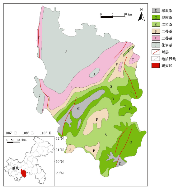
图1
研究区地理位置及地质简图
Fig.1
Geographical location and geological map of the study area
1.2 采样与分析方法
土壤样本采集严格按照中国地质调查局《土地质量地球化学评估技术要求(试行)》(DD2008-06)中的规定,采用1∶50 000 比例尺,按照4~6个点/km2采集0~20 cm表层土壤,样品采集以代表性为主要原则,兼顾均匀性与合理性,采样时避开新近搬运的堆积土和明显的局部污染区,每件样品由周围50 m 范围内4~5个子样组合而成,共采集获得表层土壤样品8 946个。为提高每个采样点上样品的代表性,采样时刮去地表落叶、杂草等表面杂物及浮土,并去除动植物残留体、砾石、肥料团块等杂物。采样原始质量大于1 kg,自然风干后,过10目尼龙筛,按250 g/个送实验室进一步处理以便测试分析。
土壤样品测定了pH、有机碳、总Se等54项指标,样品分析由自然资源部重庆矿产资源监督检测中心完成。参照《DZ /T 0295-2016 土地质量地球化学评价规范》,测试指标准确度和精密度的控制方法为:以密码样插入4个与土壤酸碱性相匹配的国家标准物质(GBW)进行分析,每个指标的每次测试分析结果计算测定值与标准值对数偏差(ΔlgC),用来衡量样品分析的准确度。选择4个不同国家一级标准土壤,重复分析完毕后,计算重复样测量值对数标准偏差(λ),用来衡量样品分析的精密度。对数偏差(ΔlgC)和对数标准偏差(λ)均小于《DZ/T0295-2016 土地质量地球化学评价规范》规定的允许监控限值。Se、As和Hg采用原子荧光法(AFS)测定;SiO2、Al2O3、Fe2O3、K2O、Na2O、CaO、MgO、Cr、Cu、Pb、Zn采用X射线荧光光谱法(XRF)测定; Ni采样等离子体光量计法测定; Cd采用电感耦合等离子体质谱法(ICP-MS)测定;有机碳采用硫酸亚铁铵容量法测定;pH采用pH/ISE测试仪测定。
2 结果与讨论
2.1 土壤Se含量及分布特征
表1 研究区与其他地区表层土壤Se含量对比
Table 1
| 地区 | 含量范围/10-6 | 平均值/10-6 | 参考文献 |
|---|---|---|---|
| 重庆市南川区 | 0.056~10.80 | 0.46 | 本文 |
| 三峡库区(重庆段) | 0.006~5.79 | 0.16 | [1] |
| 重庆市江津区 | 0.049~3.11 | 0.32 | [8] |
| 陕西紫阳 | 0.0015~36.68 | 0.94 | [13] |
| 湖北省恩施市 | 2.70~87.3 | 9.36 | [11] |
| 江西省丰城市 | 0.40~0.99 | 0.54 | [15] |
| 贵州 | 0.06~1.33 | 0.37 | [16] |
| 广东 | 0.03~1.42 | 0.28 | [17] |
| 香港 | 0.07~2.26 | 0.76 | [18] |
| 黑龙江省 | 0.008~0.660 | 0.15 | [2] |
| 东北平原 | 0.01~5.3 | 0.18 | [9] |
| 北京平原 | 0.04~5.26 | 0.2 | [19] |
| 河北平原 | 0.05~0.34 | 0.19 | [20] |
| 中国 | 0.05~0.99 | 0.29 | [21] |
| 世界 | 0.03~2.00 | 0.4 | [5] |
表2 研究区土壤Se含量分级[22]
Table 2
| 含量分级 | 硒含量阈值/10-6 | 硒效应 | 比例/% |
|---|---|---|---|
| 缺乏 | ≤0.125 | 缺Se | 1.71 |
| 边缘 | 0.125~0.175 | 潜在缺Se | 0.96 |
| 中等 | 0.175~0.40 | 足Se | 54.83 |
| 高 | 0.40~3.0 | 富Se | 42.31 |
| 过剩 | ≥3.0 | Se中毒 | 0.19 |
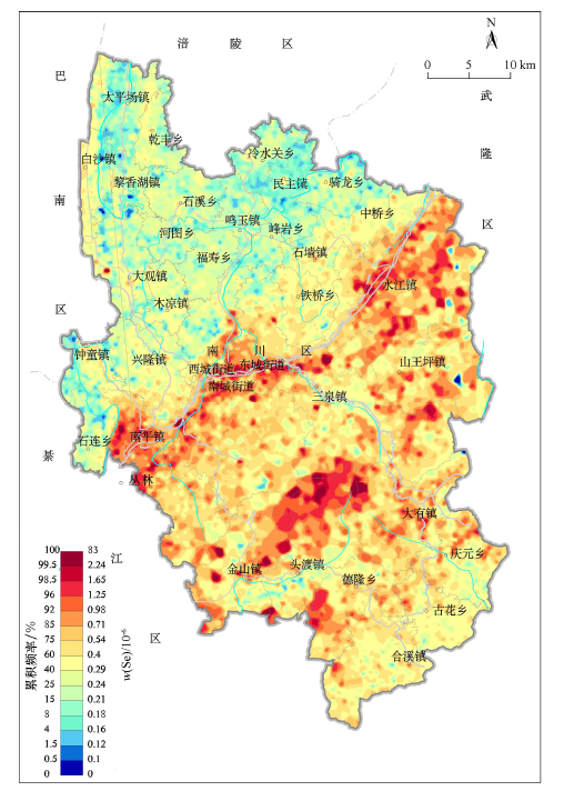
研究区表层土壤Se含量变化大,最大值与最小值相差上百倍,变异系数为83.3%,说明南川区存在局部范围的Se富集现象。如图2所示,南川区土壤Se在空间上呈现出南部高北部低的特点,土壤Se高含量区主要集中分布在南部的水江镇、南平镇、南川城区及金佛山地区。
图2
2.2 不同地层土壤Se含量特征
研究区出露的地层主要包括侏罗系(J3sn、J3p、J2s、J1-2z)、三叠系(T3xj、T2l、T1j、T1f)、二叠系、志留系、奥陶系和寒武系等多个地层。对南川区不同地层区土壤Se含量进行统计(表3),各地层土壤Se平均含量水平排序依次为:P>T1f>T1j>S>O>∈>T2l>T3xj>J1z-J2x>J3sn>J3p>J2s。二叠系地层土壤Se平均含量水平总体最高,达1.026×10⁻⁶;其次是三叠系飞仙关组(0.902×10⁻⁶)和嘉陵江组(0.754×10⁻⁶);志留系(0.573×10⁻⁶)、奥陶系(0.479×10⁻⁶)和寒武系(0.475×10⁻⁶)地层土壤Se含量也在研究区平均水平(0.460×10⁻⁶)之上;侏罗系地层土壤Se含量明显较低。
表3 研究区不同地层出露区土壤Se含量
Table 3
| 地层 | 最小值/10-6 | 平均值/10-6 | 最大值/10-6 | 标准差/10-6 | 变异系数/% | 样本数 |
|---|---|---|---|---|---|---|
| J3p | 0.064 | 0.243 | 0.593 | 0.06 | 24.62 | 653 |
| J3sn | 0.075 | 0.251 | 0.783 | 0.07 | 27.41 | 602 |
| J2s | 0.071 | 0.235 | 4.154 | 0.13 | 53.6 | 1609 |
| J1z-J2x | 0.056 | 0.326 | 2.708 | 0.19 | 57.97 | 547 |
| T3xj | 0.062 | 0.391 | 1.773 | 0.22 | 55.83 | 400 |
| T2l | 0.124 | 0.411 | 2.565 | 0.23 | 55.12 | 301 |
| T1j | 0.108 | 0.734 | 10.802 | 0.66 | 89.29 | 562 |
| T1f | 0.098 | 0.902 | 3.439 | 0.48 | 53.03 | 211 |
| P | 0.123 | 1.026 | 5.15 | 0.594 | 57.903 | 498 |
| O | 0.084 | 0.479 | 3.227 | 0.27 | 55.53 | 1604 |
| S | 0.056 | 0.573 | 5.166 | 0.37 | 64.27 | 1509 |
| ∈ | 0.066 | 0.475 | 3.388 | 0.26 | 54.52 | 450 |
南川区土壤Se的空间分布特征高度受地层控制,南部出露三叠系、二叠系、志留系、奥陶系和寒武系老地层出露区土壤Se含量高,北部侏罗系新地层主要出露区土壤Se含量相对较低。水江镇、南平镇、南川城区及金佛山地区主要出露二叠系、三叠系(飞仙关组和嘉陵江组)和志留系地层,为南川区土壤Se含量水平最高的地层。
2.3 土壤Se含量的影响因素
2.3.1 成土母质
南川区二叠系地层土壤Se平均含量水平总体最高,其次是三叠系(飞仙关组和嘉陵江组)、志留系、奥陶系和寒武系,含量水平最低的是中侏罗系沙溪庙组。与湖北恩施富硒土壤Se含量相似,高硒含量土壤主要位于二叠系和三叠系地层[23]。研究区三叠—寒武系地层碳酸盐岩发育,碳酸岩在风化过程中所产生的次生矿物及其土壤溶液,造成了有利于Se残留富集的表生地球化学环境,即在岩石风化成土过程中,Se的淋滤流失少,残留富集多,导致土壤Se含量富集。
2.3.2 土壤性质
土壤性质是影响土壤Se含量的重要因素,通过对本区域表层土壤Se 含量与土壤常量元素的相关分析(表4)表明,表层土壤Se 含量与N、P、S、Fe、Mg、Ca、Mn等含量呈显著正相关关系,与Si等呈显著负相关关系,与Al、K、Na相关性不明显;同时也发现与土壤中主要重金属均存在显著正相关关系(表5),即表明存在伴生关系。土壤中 Se 含量与N、P、S呈正相关,与有机质吸附固定硒作用关系较大[2];与Fe、Mn成正相关,与铁锰氧化物能够强烈吸附四价硒有较大关系[24];与Ca、Mg呈正相关,可能与粘土矿物的吸附作用有关[29];与Si成负相关,可能是因为高硅土壤(SiO2平均值65.10%)质地较粗,吸附性低。而土壤Se 与土壤主要重金属的伴生关系密切,建议地方在发展富硒产业时考虑重金属元素的影响。
表4 土壤Se与常量元素的相关性
Table 4
| 指标 | N | P | S | SiO2 | Al2O3 | Fe2O3 | MgO | CaO | Na2O | K2O |
|---|---|---|---|---|---|---|---|---|---|---|
| Se | 0.577** | 0.402** | 0.662** | -0.267** | -0.027 | 0.344** | 0.057** | 0.126** | -0.276 | -0.152 |
注:“**”表示在0.01检验水平(双侧)显著相关
表5 土壤Se与重金属元素之间的相关性
Table 5
| 元素 | As | Cd | Cr | Cu | Hg | Ni | Zn | Pb |
|---|---|---|---|---|---|---|---|---|
| Se | 0.301** | 0.501** | 0.463** | 0.382** | 0.065** | 0.313** | 0.194** | 0.190** |
注:“**”表示在0.01检验水平(双侧)显著相关
在土壤理化性质中,土壤pH和有机质是影响土壤元素赋存形态和有效性的两个重要因素。土壤pH是控制亚硒酸和硒酸盐之间转化的重要因素,亚硒酸盐一般存在于酸性和中性土壤中,受黏粒矿物和铁氧化物固定,常与铁形成了溶解性极低的氧化物和水合氧化物而使其有效性大大降低;而在通风较好的碱性土壤中,硒酸盐与吸附物质间亲和力较差且溶解度大,易迁移且易被植物吸收利用[25]。杨忠芳等研究则认为在中碱性土壤中Se 含量基本不受pH 制约,而酸性土壤条件下,随着pH 下降土壤Se 含量可迅速增加[24]。研究区无论酸性或者碱性土壤,Se含量与土壤pH均没有发现显著的相关关系(图3),这可能是土壤pH对土壤Se含量的影响涉及降水、土壤氧化还原电位等因素综合作用的影响,所以其影响机理还有待进一步探究[1]。
图3
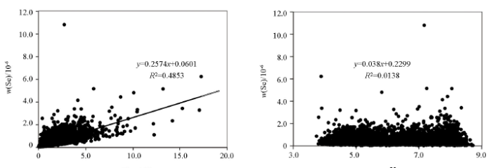
图3
研究区土壤Se含量与土壤有机质、pH的相关性
Fig.3
Correlation coefficients between Se and organic matter or pH of soil in the study area
2.3.3 海拔对土壤Se的影响
南川区土壤Se含量随海拔变化较大,土壤Se含量值总体上呈现出随海拔的增加而增加的趋势,在海拔2 000 m以上达到最大值,其平均含量水平为1.38×10⁻⁶,在海拔为0~500 m范围内平均含量最低,为0.31×10⁻⁶(表6)。笔者认为其可能的原因是研究区南部地势较高但同时也是富硒地层岩石的分布区,同时随着海拔高度的增加、气温降低,致使有机质分解缓慢,有利于土壤有机复合态Se 的累积,土壤中易被淋溶和植物吸收的Se 含量减少,最终使土壤Se 得以富集[1,28-29]。在海拔低于1 000 m范围内,土壤Se的变异系数明显大于高海拔地区,说明低海拔地区土壤Se含量更容易受到其他因素(比如人类活动)的影响。
表6 研究区不同海拔范围土壤Se平均含量
Table 6
| 海拔/m | 最小值/10-6 | 平均值/10-6 | 最大值/10-6 | 标准差/10-6 | 变异系数/% | 样品数 |
|---|---|---|---|---|---|---|
| 0~500 | 0.09 | 0.31 | 1.76 | 0.27 | 0.87 | 625 |
| 500~1000 | 0.06 | 0.43 | 10.8 | 0.38 | 0.9 | 6825 |
| 1000~1500 | 0.06 | 0.54 | 3.4 | 0.32 | 0.59 | 1343 |
| 1500~2000 | 0.2 | 0.99 | 4.44 | 0.6 | 0.61 | 129 |
| ≥2000 | 0.64 | 1.38 | 2.89 | 0.53 | 0.38 | 23 |
2.3.4 人为因素
研究发现,Se是受人类活动影响最大的元素之一,可以作为反映人类活动对土壤环境影响程度的敏感地球化学因子[30]。土地利用方式不同,对土壤性质的影响也不同,人类通过土地利用影响土壤环境,从而影响土壤中Se的含量[9]。石油及煤燃烧排放废气沉降落到土壤上,常此以往可能会导致土壤中Se 含量增加[31-32];此外,城镇垃圾的堆放也可能会增加土壤Se的含量[33]。南川区土地利用方式主要有农田、旱地、林地、园地、草地、村庄、城镇、工矿区和其他未利用地,其中土壤Se平均含量最高为城镇用地(0.90×10⁻⁶),其次为工矿区(0.69×10⁻⁶),农田用地最低(0.4×10⁻⁶)(表7)。南川区矿产资源丰富,城镇地区和工矿区土壤Se富集可能与工业企业三废排放、城镇垃圾堆放等因素有较大关系,例如南川区土壤Se富集区之一的水江地区是重庆市工业集中区,存在一批以煤和石油为能源的矿石冶炼企业,这些企业排放的废气、废水和垃圾可能会导致周围土壤Se含量的增加;此外,南川城区及金佛山地区等人为活动较多的地区土壤Se含量明显较高(图2)。
表7 研究区不同土地利用方式下土壤Se含量
Table 7
| 土地利用类型 | 农田 | 旱地 | 林地 | 园地 | 草地 | 村庄 | 城镇 | 工矿区 | 其他用地 |
|---|---|---|---|---|---|---|---|---|---|
| 样品数 | 2831 | 2193 | 2849 | 250 | 192 | 456 | 56 | 9 | 110 |
| 平均含量/10-6 | 0.4 | 0.46 | 0.45 | 0.44 | 0.45 | 0.51 | 0.9 | 0.69 | 0.5 |
3 结论
1) 南川区土壤Se平均含量(0.46×10⁻⁶)是中国土壤Se背景值的1.58倍,与我国其他地方土壤Se含量相比,重庆市南川区土壤中Se含量总体水平较高。
2) 南川区足Se和富Se土壤分别占54.83%和42.31%。南部的水江镇、南平镇、南川城区及金佛山地区土壤Se含量高于北部,城镇地区和工矿区土壤Se含量最高。
3) 南川区南部主要出露三叠系、二叠系、志留系、奥陶系和寒武系老地层,该区域土壤Se含量高;而北部主要出露侏罗系地层,土壤Se含量相对较低;反映了南川区土壤Se含量主要受成土母质控制。除成土母质外,研究区土壤Se与土壤有机质呈显著的正相关关系,总体上呈现出随海拔的增加而增加的趋势,城镇和工矿区受人为因素影响较大。
参考文献
三峡库区(重庆段)土壤硒分布特征及影响因素
[J].
Distribution of soil selenium in three gorges reservoir region (Chongqing section) and its influential factors
[J].
黑龙江省土壤硒分布及其影响因素研究
[J].
Distribution of Selenium and Its Influencing Factors in Soils of Heilongjiang Province,China
[J].
Speciation, distribution, and bioavailability of soil selenium in the Tibetan Plateau Kashin-Beck Disease area—A case study in Songpan County, Sichuan Province, China
[J].
Selenium and hum an health
[J].
DOI:10.1016/S0140-6736(11)61452-9
URL
PMID:22381456
[本文引用: 1]

Selenium is incorporated into selenoproteins that have a wide range of pleiotropic effects, ranging from antioxidant and anti-inflammatory effects to the production of active thyroid hormone. In the past 10 years, the discovery of disease-associated polymorphisms in selenoprotein genes has drawn attention to the relevance of selenoproteins to health. Low selenium status has been associated with increased risk of mortality, poor immune function, and cognitive decline. Higher selenium status or selenium supplementation has antiviral effects, is essential for successful male and female reproduction, and reduces the risk of autoimmune thyroid disease. Prospective studies have generally shown some benefit of higher selenium status on the risk of prostate, lung, colorectal, and bladder cancers, but findings from trials have been mixed, which probably emphasises the fact that supplementation will confer benefit only if intake of a nutrient is inadequate. Supplementation of people who already have adequate intake with additional selenium might increase their risk of type-2 diabetes. The crucial factor that needs to be emphasised with regard to the health effects of selenium is the inextricable U-shaped link with status; whereas additional selenium intake may benefit people with low status, those with adequate-to-high status might be affected adversely and should not take selenium supplements.
Selenium deficiency and toxicity in the environment
[G]//
Selenium in soil and endemic diseases in China
[J].
DOI:10.1016/s0048-9697(01)00889-0
URL
PMID:11846167
[本文引用: 1]
重庆紫色土区硒分布特征研究
[J].
On Distribution of selenium in purple soil region of Chongqing
[J].
重庆市江津区紫色土壤基本性质对土壤硒含量的影响
[J].
Effects of basic properties of purple soil on soil selenium content in Jiangjin district of Chongqing City
[J].
东北平原土壤硒分布特征及影响因素
[J].
Distribution of soils Selenium in the Northeast China Plain and its influencing factors
[J].
重庆土壤硒的地球化学特征及经济意义
[J].
Geochemical characteristics and economic significance of the Se-rice soil in China
[J].
锗在土壤-水稻系统的迁移累积及其影响因素
[J].
Translocation and accumulation of germanium in paddy soil-rice plant system
[J].
层次分析法在重庆市南川区矿山地质环境评价中的应用
[D].
Application of AHP in mine geological environment assessment in Nanchuan district in Chongqing City
[D].
紫阳县土壤硒的分布特征研究
[J].
Distribution of soil total selenium in Ziyang, Shaanxi
[J].
The bioavailability of selenium and risk assessment for human selenium poisoning in high-Se areas, China
[J].
DOI:10.1016/j.envint.2012.12.003
URL
PMID:23291099
Enshi prefecture of Hubei Province is well known for human selenium (Se) poisoning in the early 1960s in China. Sporadic cases of Se poisoning in livestocks are still being found. In this study, Se levels in water, cropland soils and various crops from high-Se areas of Enshi were measured to investigate the distribution and bioavailability of Se in the environments, as well as probable daily intake (PDI) of Se for local residents. The total Se in surface water ranged from 2.0 to 519.3mug/L with a geometric mean of 46.0+/-127.8 mug/L (n=48), 70.5-99.5% of which was present in the form of Se(VI). The soil Se concentration varied from 2.89 to 87.3 mug/g with a geometric mean of 9.36+/-18.6 mug/g (n=45), and most of Se was associated with organic matter (OM-Se). The total Se in rice, corn, and vegetable samples were 2.11+/-2.87 mug/g (n=21), 3.76+/-11.6 mug/g (n=16), and 2.09+/-3.38 mug/g (n=25), respectively. Stream water Se is likely leached from carbonaceous shale and mine wastes, leading to Se accumulation in paddy soils. OM-Se may play an important role in Se uptake by rice plant in high-Se area of Enshi. The PDI of Se is approximately 2144 mug/day, and Se concentration in blood is estimated at about 3248 mug/L, posing a potential chronic Se poisoning risk to local residents. Cereal consumption (48.5%) makes a great contribution to human daily Se intake, followed by vegetables (36.6%), meats (8.5%), and drinking water (6.4%). However, when assessing health risk on human in high-Se areas, the contribution of drinking water to daily Se intake cannot be ignored due to high Se content and dominant Se(VI) species. Local inhabitants should be advised not to grow crops in high-Se lands or irrigate using high-Se water. If possible, they should drink pipe water and consume foods mixed with those from outside the high-Se areas.
江西省丰城市“中国生态硒谷”创意产业的发展战略
[J].
Expand srategy on creative industry for Chinese ecological Se-tech at Jiangxi Fengcheng
[J].
贵州省土壤含硒量及其分布
[J].
Contents and distribution in soils of Guizhou Province
[J].
广东省土壤硒空间分布及潜在环境风险分析
[J].
Spatial variation and environmental indications of soil selenium in Guangdong province
[J].
香港土壤研究Ⅱ. 土壤硒的含量、分布及其影响因素
[J].
The Research of soil in Hong Kong II: The content,distribution and influencing factors of selenium
[J].
北京市平原区土壤中硒的含量和分布
[J].
Content and distribution of selenium in soil of Beijing plain
[J].
河北省平原区土壤中硒异常源追踪及生态效应评价
[D].
The study on source tracking of Se anomaly and ecological appraisal in plain terrain of Hebei
[D].
恩施典型富硒区土壤硒与其他元素组合特征及来源分析
[J].
Characteristics and sources of soil selenium and other elements in typical high selenium soil area of Enshi
[J].
海南岛农田土壤Se的地球化学特征
[J].
Geochemical characteristics of soil selenium in farmland of Hainan Island
[J].
典型富硒区岩石—土壤—植物中硒的赋存状态及环境行为研究
[D].
The occurrence state and speciation of selenium and its environmental behaviors in rock-soil-plant from typical high-Se areas
[D].
方正县土壤硒的分布特征及其与土壤性质的关系
[J].
Distribution characteristics of selenium in Fangzheng County and its relationship with soil properties
[J].
Background levels of selenium in some selected Brazilian tropical soils
[J].DOI:10.1016/j.gexplo.2014.05.007 URL [本文引用: 1]
The origin and geochemical cycle of soil selenium in a Se-rich area of China
[J].
DOI:10.1016/j.gexplo.2013.09.006
URL
[本文引用: 1]
Mianyang City, located in the Fujiang River Basin, Sichuan Province, is a Se-rich area of China. The distribution of Selenium (Se) in the Mianyang area was studied based on assay data obtained from soil, irrigation water, fertilizer, and rice (grain and stem) samples. The ratio between natural and anthropogenic sources in the area was derived by analyzing the concentrations and spatial distributions of multiple elements (such as Se,, cadmium, arsenic, and mercury) in the soil. The controlling factors affecting Se concentration in the soil were also investigated. We established a geochemical model of the Se cycle among the different media (i.e., the atmosphere, water, soils, and plants). We then calculated the annual Se flux caused by various inputs' (such as precipitation, fertilization, and irrigation) and outputs' (such as infiltration, crop harvest, removal of straws from cropland, and volatilization) pathways in the topsoil. We discuss the contribution of different pathways to the Se cycle and provide evidence for exploring Se-rich land in the study area. (C) 2013 Elsevier B.V.
洋河流域不同土地利用类型土壤硒(Se)分布及影响因素
[J].
Spatial distribution of Se in soils from different land use types and its influencing factors within the Yanghe Watershed, China
[J].
土壤微量元素与人类活动强度的对应关系
[J].
Corresponding relationship between trace elements in soil and human activity intensity
[J].
Assessment of selenium pollution in agricultural soils in the Xuzhou District, Northwest Jiangsu, China
[J].
Heavy metals in surface sediments from nine estuaries along the coast of Bohai Bay, Northern China
[J].
DOI:10.1016/j.marpolbul.2014.02.033
URL
PMID:24650542
[本文引用: 1]
Concentrations of heavy metals in river water and sediment were investigated in nine estuaries along the coast of Bohai Bay, Northern China. Multivariate statistical techniques such as principal component analysis and cluster analysis, in combination with metal concentration analysis and correlation analysis, were used to identify the possible sources of the metals and the pollution pattern in nine estuaries along the coast of Bohai Bay. The environmental risks of metals, evaluated by sediment quality guidelines and background values, revealed Hg contamination in the estuaries. However, levels of Cd in estuarine sediments were low, and they were less than those levels in river sediments, partly due to the high mobility and dilution of river or seawater. Cd did not contribute to sediment deposits in estuaries. High organic matter from effluents from large municipal sewage treatment plants was predominantly responsible for restricting Hg mobility from the river to Bohai Bay.
Extreme selenium and tellurium contamination in soils-An eighty year-old industrial legacy surrounding a Ni refinery in the Swansea Valley
[J].
