0 引言
但是,由于地质情况的复杂性,以及前期地面勘探工作的局限性(探测误差、探测精度不能满足工程需求),在地下工程施工过程中,还是难以避免不良地质构造带来的威胁。因此,在地下工程施工过程中的洞内探测工作也至关重要,能够帮助设计方和施工方及时掌握不良地质构造的走向、位置与规模,便于采取相应的处理措施,保障施工安全。
笔者提出了一种洞内的地球物理勘探方法——近垂直反射法[13],首先简要地介绍了该方法的技术原理与优势,结合工程实例对该方法开展了正演模拟研究,最后结合正演模拟研究成果,将该方法成功应用于深埋隧洞工程的断层探测应用中。
1 近垂直反射法
1.1 技术原理
垂直反射法实质上是地震浅层反射法的一种特例,它以极小偏移距[14](发射与接收间的距离趋于零)的方式进行工作,故也称之为极小偏移反射法。
近垂直反射法是以垂直反射法为基础,但是并不是每一炮检距都以极小偏移距的工作模式进行数据采集,由于近垂直反射地震排列一般不会太长,一般可在地震排列中间位置设置震源。其工作原理是:由击发震源向岩石/(土)表面发射脉冲波,当岩土体中存在具有一定规模的缺陷(如地质构造、岩溶等)时,会引起波阻抗(ρ·V)的变化,同时产生地震反射波而返回到地震传感器,如图1所示。资料处理分析过程中,可根据反射地震波信号的相位、振幅、频率及走时等变化特征来判断缺陷的范围和埋深,其深度计算公式为:
式中,H为深度,Vp为纵波速度,t为双程反射时间。
图1
1.2 地球物理条件
所有地震勘探方法的地球物理条件均为:介质之间存在波阻抗。波阻抗指岩石中的纵波速度与岩石密度的乘积。
式中,Z为波阻抗,Vp为纵波速度,ρ为岩石密度。
只有当两种介质之间的波阻抗不相等时,即Z1≠Z2,地震波才能发生反射,且当Z1和Z2差别越大,反射波越强。典型介质的波阻抗参数见表1。
表1 典型岩石波阻抗参数
Table 1
| 岩石 | 密度/ (g·cm-3) | 纵波波速/ (m·s-1) | 波阻抗/ (kg·cm-2·s) |
|---|---|---|---|
| 土壤 | 1.10~2.00 | 200~800 | 22~160 |
| 黏土 | 1.50~2.20 | 1800~2400 | 270~530 |
| 砂岩 | 2.40~2.70 | 2300~4000 | 550~1100 |
| 灰岩 | 2.60~2.90 | 3000~5500 | 780~1600 |
| 玄武岩 | 2.80~3.10 | 4500~7500 | 1260~2300 |
| 水 | 1.00 | 1400~1600 | 140~160 |
1.3 技术优势
近垂直反射法的技术优势如下:
1)地震检波器所接收到的地震波反射信号波形成分单一,不含其他的转换波。当纵波入射时,记录波形仅有反射纵波,因此,该方法的地震资料解释比较简单与直观。
2)适用于探测工作空间有限的区域,例如隧洞、巷道等地下工程。因为常规的地震反射法需选择足够大的地震偏移距,以避免先于目的层反射波到达的直达纵波、横波、声波和折射波等的干扰。
3)该技术区别于常规隧洞超前地质预报技术[15],不仅能应用于掌子面做超前探测,而且能应用于隧洞边墙、顶拱、底板等任何位置完成多方位的探测。
2 近垂直反射法正演模拟研究
2.1 均匀介质弹性波波动方程
在二维均匀介质中,弹性波波动方程为[16]:
式中,u、w分别表示沿x轴、z轴方向的位移,ρ表示介质密度,λ和μ为拉梅常数。
令Vx、Vy表示沿x轴、z轴方向的速度,τxx、τzz表示沿x轴、z轴方向的正应力,τzx表示切应力,可将式(3)和式(4)降阶,得到弹性波一阶速度应力方程:
2.2 差分格式
图2
2.3 稳定性条件
均匀介质中由谱分析法得到的稳定性条件为:
当Δx=Δz时,可化简为:
常规差分方程稳定性条件为:
由于VS<VP,则:
2.4 边界条件
地震波在真实地下介质中传播时,由于地下介质是一个无限大的空间,而在进行地震波有限差分正演模拟时,地震波在一个有限空间的模型中传播,所以必须人为的建立一个吸收边界来解决模型边界的反射问题,通过吸收边界使地震波最大限度的衰减吸收[20]。
这里引入完美匹配层边界条件模型(perfectly matched layer,PML)。PML吸收边界层在二维传播方向上吸收示意如图3所示,在左、右边界(S2、S4)处吸收沿x方向上传播的波,在上、下部边界(S1、S3)处吸收沿z方向上传播的波,在四个角处(C1、C2、C3、C4)对沿x和z方向上传播的波都进行吸收。
图3
2.5 震源
在进行地震波正演模拟时需要引入合适的震源函数,一般经常用于地震波数值模拟的震源子波函数有δ脉冲、雷克子波、指数衰减的正弦子波和高斯一阶倒数等。本文使用的是雷克子波进行正演模拟,雷克子波在时间域的表达式如式(14)所示:
图4、5是主频为400 Hz的雷克子波及其振幅谱。
图4
图5
3 工程概况与正演模拟
3.1 工程概况
在云南省某引水工程中,某主隧洞的2#施工斜井所在的山体地层岩性主要为三叠系中统下部(
图6
3.2 正演模拟
根据地质提供的工程地质图及其他地质资料,建立2#斜井与F10断层测区的地球物理模型,模型的尺寸设置为1 500 m×1 500 m,网格大小设置为5 m,即网格数为300×300,模型见图7。图中,黄色色标代表隧洞,为空气模型;紫色色标代表普通围岩,根据附近桩号TSP超前地质预报测得的波速,纵波波速设置为5 500 m·s-1;蓝色色标代表进入断层影响带的围岩,同样根据TSP探测成果,纵波波速设置为4 000 m·s-1;绿色色标代表F10断层,根据前期地面钻孔声波成果,纵波波速设置为2 800 m·s-1。
图7
分别在隧洞距离F10断层距离约120、55、20 m处附近布置3个近垂直反射地震排列,地震排列共设置8道地震检波器,道间距为4 m,整个地震排列长度为28 m,在地震排列正中心位置深度为2 m处设置激励源,采样率设置为0.05 ms,震源采用主频为300 Hz的雷克子波。3次正演模拟结果如图8~10。
图8
图9
图10
3.3 正演成果分析
1)第1次正演模拟成果:由于F10断层与正常围岩界面存在明显波阻抗差异,在时窗约45 ms附近地震波振幅增强发生强反射。
2)第2次正演模拟成果:由于F10断层与正常围岩界面存在明显波阻抗差异,在时窗约20 ms附近地震波振幅增强发生强反射。
3)第3次正演模拟成果:由于F10断层与正常围岩界面存在明显波阻抗差异,在时窗约10 ms附近地震波振幅增强发生强反射。
4 探测成果与分析
4.1 现场工作布置
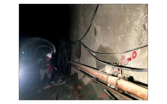
在2#施工斜井开挖过程中,共进行了3次侧向断层探测工作,主要采用近垂直反射法对右边墙的F10断层进行定位与追踪。
图11
图12
4.2 探测成果
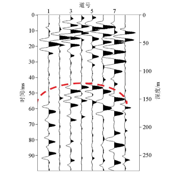
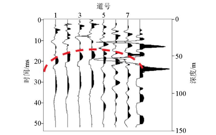
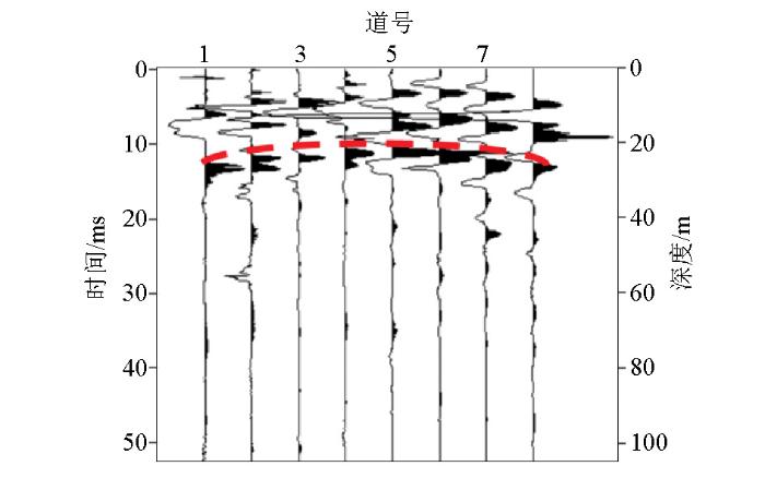
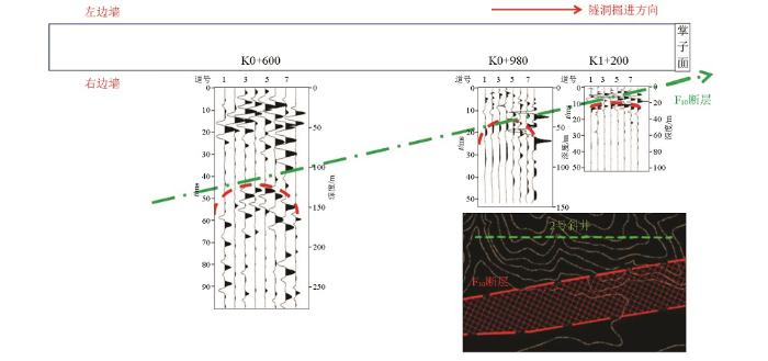
2#施工斜井洞口桩号为K0+000,第1次断层探测时,地震排列的中心位置桩号约为K0+600,附近围岩的纵波波速约5 500 m·s-1;第2次断层探测时,地震排列的中心位置桩号约为K0+980,附近围岩的纵波波速约5 500 m·s-1;第3次断层探测时,地震排列的中心位置桩号约为K1+200,由于隧洞已进入断层影响带,附近围岩的纵波波速约4 000 m·s-1。3次近垂直反射探测断层成果图见图13~15。
图13
图14
图15
4.3 探测成果分析
1)第1次探测成果:在时窗约44 ms附近开始出现地震波强反射界面,利用附近桩号TSP超前地质预报测得的平均围岩纵波波速5 500 m·s-1计算,推测F10断层距离隧洞右边墙最近的距离约120 m。
2)第2次探测成果:在时窗约16 ms附近开始出现地震波强反射界面,利用附近桩号TSP超前地质预报测得的平均围岩纵波波速5 500 m·s-1计算,推测F10断层距离隧洞右边墙最近的距离约45 m。
3)第3次探测成果:在时窗约10 ms附近开始出现地震波强反射界面,利用附近桩号TSP超前地质预报测得的平均围岩纵波波速4 000 m·s-1计算,推测F10断层距离隧洞右边墙最近的距离约20 m。
3次近垂直反射法断层探测工作均对2#斜井右侧的F10断层进行了深度定位,并通过在不同隧洞桩号的多次探测工作,对F10的发育趋势进行了追踪,3次探测成果对F10断层的定位追踪综合分析见图16。综合分析图显示综合探测成果与F10发育趋势基本一致。
图16
图16
3次探测成果综合分析
Fig.16
Comprehensive analysis chart of the three survey results
4.4 开挖验证
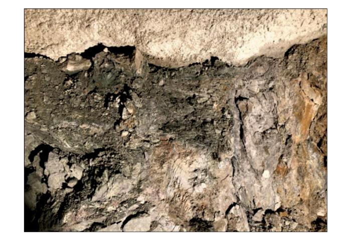
斜井开挖至桩号K1+300附近,隧洞正式进入F10断层,围岩破碎,裂隙与节理发育,稳定性差,围岩用手即可轻轻剥落,围岩波速约2 800 m·s-1。隧洞右侧边墙围岩照片见图17。
图17
5 结论
近垂直反射法是一种以垂直反射法为基础的地震探勘技术,不需要足够大的偏移距,适用于隧洞、巷道等空间较狭小的地下工程。该技术区别于常规超前地质预报技术,不仅能应用于隧洞掌子面,而且能应用于隧洞边墙、顶拱、底板等任何位置,能够对中大型地质构造(例如:断层、溶蚀带等)进行定位与追踪,能够较好地弥补前期地面勘探的“盲点”,有效保障地下工程施工安全。
在地下工程应用过程中,可根据工程现场地质情况进行正演模拟建模与模拟,结合正演模拟结果能够极大地帮助相关技术人员进行近垂直反射法的资料分析与解释。
参考文献
地下工程建设安全面临的挑战与对策
[J].详细介绍我国地下工程建设的安全管理现状和我国地下工程建设安全的严峻形势。从事故发生的类型和原因等对工程建设事故进行分析,指出责任事故及主观原因是构成地下工程建设安全管理巨大挑战的主因。结合海恩安全金字塔、海因里希安全法则、约翰逊的工程变化–失误理论模型等工程事故管理理论,提出工程事故预防的可行性和工程建设安全管理实施的对策。对重大地下工程建设中最突出的突水突泥地质灾害和岩爆地质灾害进行详细阐述,主要介绍突水突泥灾害的严重挑战、发生发展的科学规律、事故前兆信息分析以及地质超前预报等事故对策;介绍岩爆地质灾害的定义和分类、岩爆的预测机制、岩爆监测预报的理论基础和工程实践以及岩爆灾害的施工对策等。最后,针对地下工程建设的事故预防提出技术方法和管理手段的一些意见和建议。
Challenges faced by underground projects construction safety and countermeasures
[J].The status quo of safety management in China?s underground projects construction was introduced. Based on the accidents statistics,the serious security situation of underground projects construction was certificated. The analysis of types and causes for accidents indicated that the responsibility and subjective reasons are the great challenges for security management. Combining with Hain?s safety pyramid theory,Heinrich?s safety rules and Johnson?s changes-errors model,the concept that accidents can be prevented by risk management measures was established,and some suggestions for accidents prevention were put forward. Besides,the mechanism and control measures for two typical geological hazards,i. e. water and mud outbursts and rockburst,were represented. For the study of water and mud outbursts,the laws of occurrence and development,the precursory information theory,the geological prediction methods and other incident countermeasures were introduced. For the control measures of rockburst,the definition and classification of rockbursts,the prevention mechanism,theoretical basis and engineering practice for monitoring and prediction,as well as the construction measures,were introduced. Some opinions and suggestions on technical methods and management tools were put forward for the accident prevention for underground projects construction.
中国地下工程安全风险管理的现状、问题及相关建议
[J].地下工程建设具有投资大、施工周期长、施工项目多、施工技术复杂、不可预见风险因素多和对社会环境影响大等特点,是一项高风险建设工程。建立风险管理制度,对拟建和在建的城市地铁工程项目进行风险评估,继而进行风险控制十分必要,并应扩大到整个地下工程建设领域。主要论述地下工程安全风险管理的现状和地下工程安全风险管理实践中的问题,这些问题包括:(1) 缺乏规范的安全风险管理体系;(2) 工程安全风险管理责任主体不够合理,安全风险管理经费不到位;(3) 工程安全风险管理专业队伍不够规范,专业水平参差不齐;(4) 风险管理相关技术规范、标准不符合目前地下工程发展现状;(5) 缺乏合适的信息化安全风险管理平台。针对我国安全风险管理实践中的问题,提出4条建议:(1) 加强针对地下工程安全风险管理的法规建设工作;(2) 推行安全风险管理计划,将安全风险管理作为地下工程建设管理的一个必要组成部分;(3) 安全风险管理要有基于信息化技术的风险管理和预警决策支持系统;(4) 加强地下工程安全风险管理、重大事故预测预报以及防治技术的研究。]]>
State issues and relevant recommendations for security risk management of China's underground engineering
[J].Underground project is a high-risk and complex project with vast construction investment,long-term construction,numerous subprojects,complexity of construction technology,and unpredictability of risk factors and social characteristics of the environmental impact. The establishment of a risk management system,detailed risk assessment for construction of metro project,and risk control,are necessary and should be extended to the overall underground construction areas. This paper mainly describes the present status and issues existing in risk management for safety operation in underground projects,which include:(1) the lack of standardized security risk management system;(2) unreasonable safety risk management,and insufficient funding for security risk management;(3) inadequate or nonprofessional teams or uneven-developed professional level;(4) risk management-related technical specifications,standards are not consistent with the current development of underground works;and (5) the lack of appropriate security risk management information platform. Related to issues existing in risk management in China,four suggestions are proposed as follows:(1) to strengthen codification of risk management for safety in underground projects;(2) to promote risk management as an indispensable part of project management;(3) to set up an aid system for warning decision making based on informationization technique;and (4) to strengthen study on major accident prediction and prevention technique for risk management.]]>
奥林匹克公园地区隐伏断裂综合探测
[J].
DOI:10.3969/j.issn.0001-5733.2010.06.026
URL
[本文引用: 1]

14C、红外释光、古地磁、孢粉等多种测年方法进行地层年代划分.通过多种方法并行对比、验证、综合分析,以多方面综合性大量研究工作明确给出了断裂位置、结构、活动性,认为本段断裂最新活动时代为早更新世(非地震活断层).根据实践经验探讨了城市地区隐伏断裂探测的有效方法.]]>
Synthetic exploration of the buried faults in Olympic park area
[J].
厚覆盖层地区隐伏活断层探测的地震方法技术——以桥北镇—宿迁断层为例
[J].
DOI:10.11720/wtyht.2015.2.33
URL
[本文引用: 1]

地震反射勘探法是当前城市地震活断层探测的主要方法,它在厚覆盖区探测断层及其上断点的效果取决于所采用的工作方法和技术参数。桥北镇—宿迁断裂是郯庐断裂带在江苏境内一条重要的隐伏断裂。以宿迁市活动断层探测项目中针对该断裂敷设于厚覆盖层地区的QL14测线为例,为了查明测线控制地段内断裂的空间展布形态、性质以及活动性,针对不同目标、目的层深度和精度要求,作者按照组合、分步探测的工作思路,采用了不同的地震勘探方法技术和采集参数对其进行了高分辨率地震反射成像,解决了地质任务要求与野外资料采集方法之间的矛盾,从而获得了埋深约16~450 m范围内高分辨率的地层结构和非常清晰的断裂构造图像,为钻孔联合剖面位置的布设、钻孔深度的设计以及断裂活动性的评价提供了地震学依据。最后经高精度钻孔联合地质剖面证实,地震勘探方法反演得到的主要地层界面和构造特征都与钻孔联合地质剖面吻合较好。试验结果表明:采用组合探测的方法能够获得断层在不同深度的产状、展布以及由深至浅完整的分布图像;地震勘探法在厚覆盖区确定隐伏断层具体位置和判定断层活动性具有可行性以及地震勘探与钻孔联合地质剖面相结合的工作方法具有有效性。
The seismic exploration method for buried active faults in thick sediment area:A case study of Qiaobei-Suqian fault
[J].
DOI:10.11720/wtyht.2015.2.33
URL
[本文引用: 1]

Seismic reflection exploration is the main technique in present urban active faults detecting.The effect of investigating fault and its up-breakpoint in thick Quaternary sediments depends on the working methods and technical parameters.Qiaobei-Suqian fault is an important buried fault along Tan-Lu fault zone in Jiangsu. In this paper,based on QL14 line laid on the fault in thick sediments during the active fault survey in Suqian City and aimed at investigating the spatial distribution,characteristics and activities of the fault controlled by the line,the authors used different seismic exploration methods and acquisition parameters to perform a high-resolution seismic reflection experiment and obtain the imaging of buried fault in the light of the work thinking of combination and fractional steps and according to different targets,the depth of the target layer and the accuracy requirement.The technique solved the contradiction between the field data acquisition and the geological task.The authors obtained high-resolution images of structures in the depths of 16~450 m after data processing,and the prospecting results provide seismological evidence for the position layout of composite drilling sections,the depth designing of drilling and the evaluation of fault activity.The high-precision composite drilling geological sections show that the main stratigraphic boundaries and tectonic features obtained from the seismic exploration methods are quite consistent with the results from the composite drilling geological section.The experimental result shows that the combined detection methods can receive the attitude and distribution of the fault in different depths and the complete distribution image from the depth to the shallow part of the fault.The feasibility of the seismic exploration methods for locating the buried fault and determining its activity in thick Quaternary sediments and the efficiency of the combination of seismic exploration and composite drilling geological profiles are also demonstrated in this study.
高分辨折射和浅层反射地震方法在活断层探测中的联合应用
[J].
Joint application of high-resolution refraction and shallow reflection seismic exploration approach to active fault survey
[J].
音频大地电磁法对深部隐伏构造的识别与应用:以贵州省松桃县李家湾锰矿为例
[J].
Identification and application of audio magnetotellurics to the deep buried structure:a case study of Lijiawan manganese deposit at Songtao county in Guizhou Province
[J].
南水北调西线工程区活动断层CSAMT技术探测研究
[J].结合南水北调西线工程调水区桑日麻断裂的探测,就应用可控源音频大地电磁测深(CSAMT)进行断层深部特征的探测问题进行了分析和研究。研究结果表明,可控源音频大地电磁测深法可用于探测断层深部的发育情况,为分析工程地质问题提供基础性资料,并且可以很好地指导钻探工作的布置。]]>
Application of CSAMT to prospecting active fault
[J].The feasibility problem of application of CSAMT to prospecting active fault in the West Route of South-to-North Water Transfer Project is studied. The study results show that CSAMT can be applied to prospect the characteristics of deep region of active fault for engineering design. Some beneficial conclusion and advice about geological prospect are obtained.]]>
CSAMT在某重大城市活动断层探测中的应用
[J].
DOI:10.3969/j.issn.1004-2903.2010.04.030
URL
[本文引用: 1]

某城市位于我国南北地震带中段东侧,是一个中强地震频发的地区,1996年被国务院列为全国地震重点检测防御城市,因此该城市的地震活动断层的探测任务非常紧迫.为了对该城市的活动断层进行探测和评价,需查明区内断裂的准确位置、产状以及覆盖层厚度.采用CSAMT方法进行了勘察工作,由于区内人文干扰和电磁干扰严重,野外施工时采用了多种手段以保证观测数据的可信度;采用CSAMT全资料反演程序对野外数据进行反演.分析反演结果并结合已知地质资料,描述了3个背斜形态,识别出了多条断层.
Application of CSAMT to detection of active faults
[J].
DOI:10.3969/j.issn.1004-2903.2010.04.030
URL
[本文引用: 1]

The city is located on the east side of the middle part of the north-south seismic belt, which is an area where earthquakes occur frequently. It is listed as one of the key cities for monitoring and preventing earthquakes by State Council in 1996. The detection work for the seismic active faults is very urgent. In order to detect and appraise the active faults in the city, the precise location, occurrence and thickness of the overburden of the faults in the area should be found out. The authors used the CSAMT method for the survey work, and adopted a variety of skills to ensure the reliability of the observation data during the field work for the man-made and electromagnetic interference is severe. And the authors also use the full data inversion program to inverse the data. The information such as the precise location is given by analyzing the inversion results combining with the known geological data.
活动断层高密度电法响应特征与应用研究
[J].
DOI:10.6038/pg20140460
URL
[本文引用: 1]

活动断层探测作为减轻地震灾害而开展的一项重要工作,一直被人们所关注.高密度电法已广泛应用于地质调查中,为了进一步认识高密度电法不同装置的探测效果及活动断层探测的高密度电法装置的有效选择,本文进行了温纳装置、二极装置、偶极-偶极装置、三极装置和温施装置的理论模型正反演研究,以及常用的温纳装置、温施装置和偶极-偶极装置的实例应用研究与分析.(1)基于断层是否穿过第四系判断断层活动的前提,理论模型模拟表明高密度各装置均可进行活动断层的定性探测和进行地质分层,而表层为相对高阻层的地层结构有利于进行地质分层,其精度高于表层为相对低阻层的地层结构;(2)模型模拟表明高密度偶极-偶极装置进行活动断层的定性探测和地质分层是最有效的装置,三极装置次之;(3)理论模拟和实例应用表明,高密度偶极-偶极装置对活动断层的响应最敏感,可有效确定其性质,这与理论模拟结果完全相符,因此实际应用时宜采用偶极-偶极装置进行活动断层的探测.
Study on the response characteristics and application of high density resistivity method of active fault
[J].
DOI:10.6038/pg20140460
URL
[本文引用: 1]

As an important work for the reduction of earthquake disasters, active fault detection has been concerned by people all the time. High density resistivity method has been widely used in geological survey. In order to further understand the detection effect of high density resistivity method with different device and effectively select the devices of high density resistivity method for active fault detection, in this paper, we do some research on the forward modeling and inversion of theoretical model by use of wenner device, two-pole device, dipole-dipole device, three-pole device and wenner-schlumberger device. Besides, we also present the practical application and analyses with wenner device, wenner-schlumberger device and dipole-dipole device which are in common use. (1)Based on the premise that whether the fault pass through the quaternary to judge the fault activity, theoretical model simulation indicates that all the device can carry out the active fault qualitative detection and geologic stratification. In addition, Surface structure which is a relatively high resistance layer is more favorable for geologic stratification and has higher accuracy than a relatively low resistance surface structure; (2)Theoretical model simulation indicates that dipole-dipole device is the best device to active fault qualitative detection and geologic stratification, followed by three-pole device; (3)Theory simulation and application indicates that dipole-dipole device is the most sensitive to active fault's response and effectively confirm the fault property which is consistent with the theoretical simulation results. Therefore, we should use the dipole-dipole device to detect active fault in the practical application.
微动探测:地层分层和隐伏断裂构造探测的新方法
[J].微动探测作为地层分层和隐伏断裂构造探测的物探新方法,已成为盆地结构调查、地热井位选址和隐伏地质构造探测的重要物探手段。微动测深确定岩性差异较大的地质界面,如新生界地层底界、侏罗系与二叠系地层分界面、二叠系-石炭系灰岩顶界面等,深度误差可控制在5%左右。断层破碎带/隐伏断裂构造在微动视S波速度剖面上显示为低速异常或明显的速度差异,易于识别、解释。二维微动剖面技术已在探测隐伏地质构造(断层、陷落柱等)方面取得较好地质效果。本文介绍其原理、方法和应用实例。
Microtremor survey method:A new geophysical method for dividing strata and detecting the buried fault structures
[J].Microtremor survey as a new geophysical method has become an important technology for dividing strata, detection of basin structure, site selection of geothermal wells and survey of the buried fault structures and geological structures in mining area. The microtremor sounding method is used to detect geological interface with the distinct lithological differences in the error of the depth of about 5%, such as the lower boundary of the Cenozoic strata, the interface between Jurassic and Permian formations and the top interface of Permian to Carboniferous limestone, and so on. Fault fracture zone and buried fault structures are easy to be identified and interpreted with low velocity anomalies or obvious velocity differences in the apparent velocity profile of S-wave from microtremor survey. 2D microtremor profiling technique has made better geological effects in the detection of buried geological structures (faults, collapse breccia pipes, etc.). This article describes the principles, methods and its applications.
利用微动勘察方法探测煤矿陷落柱
[J].
DOI:10.3969/j.issn.0001-5733.2009.07.028
URL
[本文引用: 1]

陷落柱是危害煤矿安全生产的主要因素之一,如何有效探测陷落柱是实现煤矿安全、高效生产的当务之急.本文首次将微动勘察方法应用于煤矿采区勘探,结果表明,该方法对陷落柱异常区反映敏感.在山西潞安漳村煤矿2002工作面测区已知陷落柱上,无论是单点反演获得的S波速度结构,还是微动视S波速度剖面,均能清晰显示陷落柱.微动剖面确定的陷落柱位置与巷道揭露位置一致,边界误差在10 m左右.微动勘察方法是探测陷落柱的一种行之有效的物探方法,由于其分辨率高、无需人工源、野外施工方法灵活便捷、不受施工场地限制等特点,对探测村庄覆盖区之下的煤层构造、圈定陷落柱等,具有得天独厚的技术优势和应用前景.]]>
Mapping collapsed column in coal mines utilizing microtremor survey methods
[J].
地球物理方法探测活动断层效果和方法最佳组合分析
[J].
The function of geophysical method in active fault detection and discuss of combining methods
[J].
水工隧洞综合超前地质预报应用对比研究
[J].
Comparison research on comprehensive advanced geological prediction of hydraulic tunnels
[J].
陆地声纳法及其应用效果
[J].
Land sonar method and effectiveness
[J].
隧道施工超前地质预报研究现状及发展趋势
[J].超前地质预报是隧道施工中必不可少的环节,对隧道信息化施工、灾害防治和安全保障具有重要作用。在收集整理国内外研究资料的基础上,总结钻爆法和TBM施工隧道的超前地质预报技术的研究现状。钻爆法施工隧道超前预报技术取得较大进展,涌现出一批专用的反射地震类、电磁类和电法类超前探测地球物理方法、技术与设备,逐步形成定量化探测思想和综合超前预报技术。认为基于多元地球物理信息融合与联合反演理论的综合超前地质预报技术是压制探测多解性、提高预报可靠性的可行有效途径;激发极化技术和核磁共振技术则由于其参数对水量的响应敏感性在定量探测水量方面显示出较好的应用前景。同时,TBM施工环境具有其特殊性和复杂性,少数几项专用探测技术的探测效果无法满足工程需要,总体上处于初步研究阶段,尚没有可用、可靠、有效的超前预报技术。结合课题组的研究特色,介绍3种自主研发的钻爆法隧道超前预报技术的最新进展及其用于TBM环境的可行性,提出了四阶段全过程的隧道综合超前地质预报体系,初步形成基于约束联合反演理论的综合预报方法,在钻爆法施工隧道定量化超前预报方面进行有益探索。最后,对隧道施工超前地质预报的发展趋势及其中的关键问题进行预测,认为以下4个方向是今后研究的重点和趋势:(1) 隧道施工定量化超前预报理论与技术的发展深化;(2) TBM施工隧道超前地质预报技术与装备;(3) 钻孔精细超前探测理论与技术;(4) 实时超前地质预报与施工灾害监测技术。
State of art and trends of advanced geological prediction in tunnel construction
[J].Advanced geological prediction has been an essential part in tunnel construction and has played an important role in aspects of informative construction,disaster prevention and safety guarantee in tunneling engineering. The state of the art and the trends of advanced geological prediction in drilling and blasting tunneling and TBM tunneling are summarized according to the available data. Great progress has been made in the advanced geological prediction in drilling and blasting tunneling with the emergence of a set of special methods,technologies and equipments,such as the reflection seismic method,the electromagnetic method and the electrical resistivity method,which gradually led to achieve quantitative detection and form a method of comprehensive advanced geological prediction. The comprehensive advanced geological prediction based on the fusion of multiple geophysical information and the method of combined inversion was considered an appropriate way for suppressing the multiple solutions and enhancing the reliability of advanced prediction. The methods of induced polarization and nuclear magnetic resonance have shown great prospects in the quantitative detection of water because of the sensitivity response of its parameters. Due to the particularity and complexity in the environment of TBM tunnel construction,some special detecting technologies did not meet the requirements of engineering practice which are at the preliminary stage of study and there have been no reliable and effective technologies for advanced prediction available generally. The latest developments in our group regarding three kinds of advanced prediction technology in drilling and blasting tunneling and its applicability to TBM tunnelling were described here. A system of comprehensive advanced geological prediction with four stages was proposed based on the theory of constrained joint inversion. The future studies are considered to be in the following four directions:(1) the further development of comprehensive quantitative detection during tunnel construction;(2) the technologies and equipments of advanced geological prediction in TBM tunnelling;(3) the theory and technology of precision probing at drilling;(4) the real time advanced prediction and construction disaster monitoring.
弹性介质中瑞雷面波有限差分法正演模拟
[J].为研究瑞雷面波的形成机理及传播规律,促进瑞雷面波资料处理方法的发展,本文根据弹性波方程,采用交错网格有限差分数值求解算法,对浅层各向同性弹性介质进行了包括瑞雷面波和体波在内的全波场模拟. 提出了变系数吸收边界条件并将之应用于正演模拟,使边界条件的处理简单而高效,同时给出了角点的处理方法. 对工程勘察中常见的连续和层状介质模型进行了模拟,获得了更加接近实际情况的地震记录. 结合模拟记录,探讨了瑞雷面波的形成条件,同时讨论了震源埋深对面波能量的影响.
Finite difference modelling of Rayleigh surface wave in elastic media
[J].
塔里木地区勘探地震正演模拟研究
[J].
DOI:10.3969/j.issn.0001-5733.2010.08.013
URL
[本文引用: 1]

以塔里木前陆盆地地质背景为模型,采用三维任意差分精细积分方法并行算法实现了库车地区三维正演模拟.三维任意差分精细积分方法通过时间域采用局部积分半解析方法求得波动方程的递推算子,与常规的差分法相比计算精度有较大提高;文中计算稳定性根据实际算例进行分析,采用稳定因子约束,得到较好的稳定性;边界条件采用改进的自适应吸收边界,并通过串行程序并行化,大大减少了三维正演模拟的耗时,完成了大数据量三维正演模拟.
Forward modeling research for seismic exploration of Tarim area
[J].
陆相断陷盆地复杂地质模型建立与正演模拟
[J].仿Marmousi模型论证地震方法的思路,本文以济阳断陷盆地多期构造运动形成的构造格局和六种典型构造模式为研究对象,把胜利油田典型的地质特点浓缩到一个模型中,即陆相断陷盆地复杂地质模型,简称“胜利油田典型模型”。文中论述了建立模型的具体过程和方法,即先建构造模型,再建地层、岩性模型;然后介绍了胜利油田典型模型的正演模拟及其数据体在研究叠前深度偏移方法和观测系统设计方面的应用。应用效果表明此方法具有良好的应用前景。
Buildup of complex geologic models in continental fault depression basin and their forward simulation
[J].Using similar thought as Marmousi model for demonstration of seismic approach and taking structural configuration, formed by multi-period tectonic movement and 6 typical structural models in Jiyang fault depression basin as studied objects, the paper compressed the typical geologic feature of Shengli Oilfield into one model, i.e. complex geologic model in continental fault depression basin, simply called "Shengli Oilfield typical model". The paper expounded the concrete model-building process and method, i.e. first to create structural models and then to build up stratigraphic and lithologic models. The paper also introduced the forward simulation of Shenli Oilfield typical model and application of their data volume to study prestack depth migration and design of geometry. The application effects showed the method has good application prospect.
三角谱元法及其在地震正演模拟中的应用
[J].
DOI:10.6038/cjg20140419
URL
[本文引用: 1]

谱元法(SEM)是基于有限元(FEM)的一种算法,在地震正演模拟中应用广泛,但是大部分研究都是基于四边形网格下的谱元法.本文给出了2阶谱元法在三角网格中(TSEM)的基本原理,包括Lagrange形函数的构建,数值积分公式的选取.在此基础上,分析了2阶TSEM方法的数值频散特性以及稳定性条件,并引入三角网格下3阶有限元方法进行分析对比,数值算例的结果证明2阶TSEM相比于3阶FEM具有更高的计算精度,以及更宽松的稳定条件.最后,本文将TSEM方法应用于中国西部地区的两个含溶洞介质的地质模型中,数值模拟结果表明TSEM方法能够有效地模拟复杂结构的介质,有助于对地震波场传播特性的认识.
Spectrum element method with triangular mesh and its application in seismic modeling
[J].


