
0 引言
对龙门山断裂带的研究,前人已经进行了大量的工作,其中大地电磁测深方面的工作主要有以下研究成果:在松潘—甘孜褶皱带20 km以下存在一个明显的低阻层,表明在青藏高原长期的东向挤压作用下,受四川盆地的阻挡作用,造成上、下地壳解耦,从而形成上地壳沿壳内低阻层顶部边界的逆冲推覆,导致松潘—甘孜褶皱带的地壳的强烈变形[6];在青藏高原下20 km深处存在一个低阻层,并一直延续到龙门山断裂带以西25 km处,这一低阻层是连续的,表明是富含流体的,且在四川盆地和龙门山下部,存在贯穿整个地壳的高阻体,这一高阻体的存在使流体的流动成为可能[7];松潘—甘孜褶皱带由浅至深电性结构呈现高—低—高的分布特征,四川盆地由浅至深电性分布特征则是低—高,而龙门山断裂带则呈现较为复杂的电性分布特征,松潘—甘孜褶皱带下20~45 km深处存在的低阻层表明在地壳中下部可能存在连续的走滑断层,而四川盆地下则没有,存在于龙门山断裂带以下上地壳的叠瓦状逆断层则表明松潘—甘孜褶皱带上冲于扬子板块[8]。楼海等[9]利用龙门山断裂附近宽频地震台站数据进行研究,结果表明松潘—甘孜褶皱带的下地壳处于富含流体或温度较高的部分熔融状态,有助于青藏高原的下地壳物质向东运动。
本文利用在该区采集的大地电磁数据,旨在从电学性质的角度研究龙门山断裂带及其邻区的壳幔深部电性结构,并为进一步探讨青藏高原物质东向逃逸问题提供参考依据。
1 大地电磁数据野外采集和室内分析
1.1 数据采集
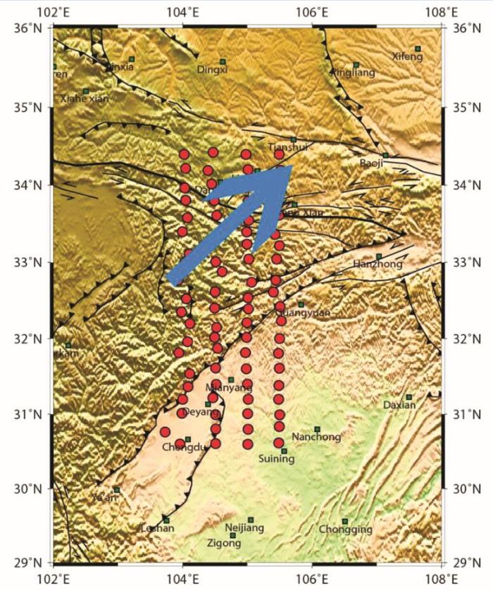
龙门山断裂是青藏高原和扬子板块的边界,其走向趋近于SN向,主要由茂县—汶川、北川—映秀、彭县—灌县三条断裂带组成,长约400 km,宽约30~60 km,从南边的保兴乡一直到北边的广元市。这片区域有极其复杂的地质背景和极其集中的板块活动。龙门山断裂带是四川盆地从海拔500 m一直升到松潘—甘孜褶皱带海拔4 000 m的转换带。
2013年,我国启动了 “中央造山带与南北构造带交汇区地壳深部地质调查项目”,中国地质大学(北京)承担下属子课题“中央造山带与南北构造带交汇区大地电磁测深阵列观测”。本文选取点位范围为30.6°~34.4°N,104°~105.5°E的4条大地电磁测深数据(图1)。4条剖面由西向东分别沿经线104°E、104.5°E、105°E和105.5°E呈SN向展布,由北向南分别跨越西秦岭造山带、松潘—甘孜褶皱带以及四川盆地,共有80个宽频大地电磁测深点以及16个长周期大地电磁测深点,点距平均约20 km。
图1
图1
研究区大地电磁测深数据点位示意
红色圆点为宽频大地电磁测深点, 蓝色圆点为长周期大地电磁测深点
Fig.1
The position indication of magnetotelluric sounding data in the study area
The red dot is the wide-band magnetotelluric sounding point, and the blue dot is the long-period magnetotelluric sounding point
文中的宽频数据采集仪器使用加拿大凤凰公司生产的MTU5-A和MTU5-P仪器,长周期数据采集仪器使用乌克兰生产的Lemi(图2)。
图2
图2
宽频及长周期大地电磁测深仪
Fig.2
Broadband and long period magnetotelluric sounding instrument
剖面所经过的各个块体内部典型测点的视电阻率与相位曲线如图3所示,1040330点位于松潘-甘孜褶皱带内,1045342点位于西秦岭造山带内,1055312点位于四川盆地。从视电阻率曲线上可以看到,各个区块的电性结构各不相同。松潘—甘孜褶皱带的电阻率由浅部至深部逐渐降低;西秦岭造山带的电阻率纵向上呈现“低—高—低”的分布特征,且随着周期的变大,XY模式和YX模式的曲线出现了较大的差别;四川盆地的电阻率曲线形态较为平缓,随着深度的增加,电阻率呈较为平稳的上升趋势。
图3
图3
研究区内不同区块视电阻率及相位曲线
Fig.3
Apparent resistivity and phase curves of different blocks in the study area
1.2 数据处理与分析
1.2.1 功率谱挑选
另外,由于低频段数据相对高频数据来说采样数据量较小,因此,在对低频数据进行功率谱挑选时,要尽量对其有用的信号进行保留,否则反演时对深部信息的反应是不可信的。
1.2.2 远参考处理
20世纪80年代,Gamble等提出了远参考技术[10],即在离测点足够远的地方布设一套仪器,采集两个水平磁场的数据,这样就能有效地消除或者减小噪声所带来的影响。
野外工作中,一天同时布设多套MTU-5A或者MTU5-P仪器,且点距最小都有20 km,使远参考成为了可能。
1.2.3 构造走向分析
在对大地电磁测深数据进行反演之前,首先需要确定研究区域的构造走向,然后将测深数据旋转至构造走向方向上,此时才能将测深数据分解为两组相互独立的极化模式,即TE极化和TM极化,这样通过二维反演能获得较为可靠的电性结构模型。本文利用相位张量与阻抗张量GB分解[18]两种方法来综合分析并确定区域构造走向的方向。
图4
图中椭圆长轴方向对应电性主轴方向,可通过参数β及λ的取值给出区域电性结构维性判定的必要非充分条件。3-D电性结构的必要条件:β非零;2-D电性结构的必要条件:β为零,λ非零;1-D电性结构的必要条件:β及λ 均为零。
根据相位张量的定义及物理意义可知,它既能通过其偏转方向(即α-β)反映出构造走向信息,也能通过其极化程度和填充其中的颜色(skew)反映出维性特征。
图5中给出了在1、10、100、1 000 s四个周期值下相位张量的分布情况,其中每个椭圆对应的二维偏离度由不同颜色示出。由图中可以看出,四川盆地内,在浅层,数据一维性较好,随着深度的增加,逐渐表现为二维特性;以龙门山断裂为界,四川盆地北边的松潘—甘孜褶皱带的数据在浅层表现为较强的三维特性,这与其浅层极为复杂的地表有关,随着深度的增加,也逐渐表现为二维特性;而西秦岭造山带的走向最为复杂,呈现较为复杂的三维特性。整体而言,数据的二维特性并不是特别明显,深部地区表现为较为复杂的三维特性。
图5
在此基础上,近一步对MT数据进行了多点、多频段的阻抗张量GB分解,并根据各个频段的统计结果,绘制了1~10 s、10~100 s和100~1 000 s三个频段的玫瑰图(图6)。三个频段的电性主轴分析结果差别不大,西秦岭造山带浅层表现为较为复杂的维性结构,而在深部表现为较好的二维性,且构造走向与礼县—宕昌断裂吻合,为NNE方向;松潘—甘孜褶皱带走向基本上是NE方向;龙门山断裂带处浅层的电性结构基本与构造走向相吻合,在深部,电性主轴方向与浅层构造方向不吻合,说明龙门山断裂深部构造走向与地表构造走向不同;四川盆地内部的构造走向基本上是NEE方向。以上结果与相位张量的分析结果也是基本一致的,从而进一步证明了构造走向分析结果的可靠性。
图6
2 反演计算与电性结构
2.1 二维反演
在三维结构下,TE模式的视电阻率曲线比较容易受到三维畸变的影响[21],TE模式对模型的二维性要求比TM模式高得多,由于有些剖面的二维性不太理想,因此选择TM模式对剖面进行反演计算。反演中,南北向拉测线,由西向东剖面分别命名为line_104、line_104.5、line_105和line_105.5,反演参数为:正则化因子τ=10,TM视电阻率误差级数为10%,相位误差级数为5%。初始模型半空间电阻率为100 Ω·m,反演使用的MT数据是从0.01~10 000 s,迭代200次,最后4条剖面的反演拟合误差分别是3.1、1.9、2.5和1.2,总体反演拟合效果非常好,如图7所示。图7中的实测数据与模型响应数据的拟断面图,除了某些频段有微小差异之外几乎完全一样,证明实测数据和反演模型响应结果非常一致,反演结果是可靠的。
图7
图7
不同剖面实测与二维模型理论计算的TM极化模式的视电阻率和阻抗相位对比
Fig.7
The comparison diagram of apparent resistivity and impedance phase of TM polarization modes measured on different profiles and calculated by two-dimensional forward
图8为4条剖面的二维反演电性结构模型图。
图8
图8
不同经线二维反演电性结构模型
Fig.8
The 2-D inversion electrical structure model of different longtitude
2.2 三维反演
由于研究区内很多区域均显示为较强的三维性,因此,需将大地电磁测深数据进行三维反演。本文所采用的是美国Oregon州立大学Gary Egbert教授课题组开发的基于NLCG算法的ModEM代码,初始模型均为100 Ω·m的均匀半空间。
图9
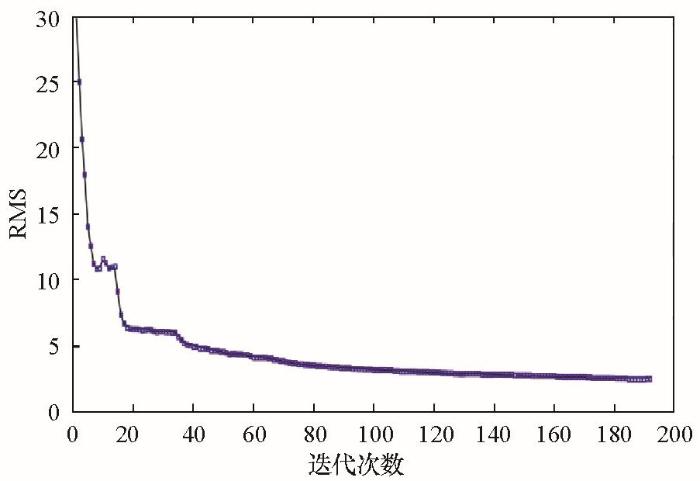
图9
三维反演过程中rms拟合差随迭代次数变化
Fig.9
The variation of rms value with the change of iteration times during the 3-D inversion process
图10
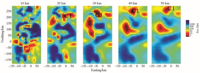
图10
研究区三维反演不同深度切片
Fig.10
The 3-D inversion slice diagram of different depth in study area
3 电性结构分析
从二维反演的电性结构模型(图8)中可以看到,四川盆地纵向上呈现为低—高的电阻率分布特征,松潘—甘孜褶皱带纵向上呈现为高—低—高的电性分布特征。从反演的模型图中可以明显看到,龙门山断裂带随着深度的加深有明显的南倾,而松潘—甘孜褶皱带下20~50 km左右出现的低阻层向东范围逐渐减小,在line_105.5的反演结果模型中,这一低阻体已经消失,推断此低阻体的成因可能是断层裂隙的空隙内含较为丰富的水引起的。
从三维反演模型(图10)中可以看到,在30 km以浅,龙门山断裂带基本上与电性梯度变化带重合,说明龙门山断裂带是深达地壳中部的深大断裂带。四川盆地则是在15 km以浅表现为低阻,从15~70 km呈现出高阻,70 km以深又开始呈现为低阻。四川盆地的浅层低阻推测为第四系覆盖及陆相沉积的碎屑岩的综合反映,而70 km以浅所呈现的高阻,则与四川盆地坚硬的结晶基底有关,70 km以深的低阻体则是推断为上地幔低阻层凹陷区。松潘—甘孜褶皱带在20 km以浅呈现以高阻为主的较为复杂的电性结构分布特征,这与其复杂的地表构造有关,而在20 km以深,则明显划分为两块,其中西北部呈现为低阻体,而东南部接近龙门山断裂带附近则呈现为高阻异常体,推测东南部的高阻可能是对四川盆地的基底的反映,这也表明松潘—甘孜褶皱带推覆到了四川盆地以上。
四川盆地内深部电性结构相对简单,具有浅部低阻、深部高阻的二元分层结构特征。上部小于15 km整体为中低阻电性层,6 km以上的低阻层推断为第四系覆盖和厚度较大的陆相中、新生界碎屑岩系的综合反映;深度从6 km至15 km的中低阻交互层,推断解释为震旦系至中三叠统海相地层,以碳酸盐岩为主夹碎屑岩。盆地基底面深度在15~20 km,具有波状起伏变化特点,由火山变质岩系组成,为高电阻率层;基底及以下的电性层可解释为包括太古宇—南华系的变质岩及花岗岩。因此,在深部15km以下,尽管有间夹不连续的壳内低阻层存在,但总体上看,四川盆地基地为中下地壳结晶基底和花岗岩层形成的高阻稳定块体。
松潘—甘孜褶皱带浅层的高阻推断解释为三叠纪复理石杂岩,高阻层下出现的低阻体推断由局部熔融物质或含盐水流体形成的,有可能是壳内物质流动的通道,从而在地下物质发生大规模走滑运动的过程中起到引导的作用[22]。
4 讨论
众多学者认为,青藏高原物质“东向挤出”实际上是地壳物质的缓慢地“蠕动”,而非刚性地块的挤出,如果地壳物质是以塑性状态向东迁移,那么必然存在物质东流的通道。从电性结构的角度分析,如果地壳物质是以塑性向东“逃逸”,那么蠕动的物质本身就应该表现为低阻特征,而物质东流的通道,无论是断裂构造,还是位于通道内的东流物质,在导电性上都应该表现为低阻特征[12]。
图11
研究表明,能够引起地球内部产生低阻异常体的物质主要包括:金属矿物质、地质构造边缘带上的石墨薄片、含盐水流体以及部分熔融物质。金属矿物的电阻率很低,但是其分布范围以及埋深有限,不可能形成如反演模型图中那样大片的、贯穿断裂带的低阻异常体。石墨广泛存在于地球的内部,电阻率十分低,但是石墨作为有效导体的前提就是石墨膜层必须相互连接起来,结合研究区域的地质地球物理概况发现,大量存在低阻异常体的区域,拥有不同的构造演化过程和期次,是不可能将如此大范围的石墨膜层相互连接在一起的。含盐水流体的最大NaCl浓度为25%,这也对应着最小的电阻率,然而,在中下地壳的环境下,含盐水流体处于不稳定的连接状态,且不可能有较高的含量,故而单独用含盐水流体来解释这一区域大量的低阻异常是不可能的。
地壳中岩石的导电性与许多因素有关,如岩石成分、结构、湿度、温度、压力、所含水溶液的矿化度等,其中,以含水的情况影响最大。在地壳深处,在剧烈的地质构造活动区,地壳中岩石处于高温、高压状态下,可能发生熔融、流变等现象,这将对岩石的导电性有极大的影响。如果岩石处于部分熔融状态,那么其流体电导率将取决于流体的量以及流体之间相互连接的程度(互连性)。流体的互连性是一个重要参数,一旦流体相互连接形成网络,电流将能够沿着导电性流体的路径流动,岩石的总电导率就会有很大程度的升高。
实验表明,干燥的岩石在温度为1 200 ℃左右开始融化,这使得岩石的电导率快速升高。由于不同岩石的组份各不相同,干燥岩石在纯熔融状态下的电导率一般在1~10 S/m之间。干燥岩石的电导率随温度的升高而增大,随压力的增大而减小,但一般不会超过10 S/m。含水岩石的熔融温度要更低一些,一般为650 ℃左右。含水岩石的电导率也随温度的升高而增大,其电导率一般在1~20 S/m之间,比干燥岩石在熔融情况下的电导率要稍高一些。地球动力学的模拟研究以及地震研究都为地壳深处的温度提供了间接的资料,表明在15~20 km的深度范围内,地壳的温度能低至 400 ℃,也能高达 700 ℃。这些证据表明:中地壳的温度不足以使岩石在干燥状态下发生熔融,但含水熔融却是可能的。
收集归纳大地热流值测量结果并进行计算,得到构造单元岩石圈的热结构参数(表1)。可以看出,礼县—柞水一段拥有较高的地表热流值和深部热流值,而四川盆地北缘流值则比较低,表明青藏高原物质向东逃逸的过程当中,遭到较为坚硬的四川盆地的阻挡,很有可能沿礼县—宕昌一带移动,导致此区域较高的热流值。
表1 研究区岩石圈热结构参数统计
Table 1
| 构造单元 | 地表热流值 /(mW·m-2) | 深部热流值 /(mW·m-2) | 莫霍面深度 /km | 莫霍面温度 /℃ | 岩石圈厚度 /km | 岩石圈温度 /℃ |
|---|---|---|---|---|---|---|
| 鄂尔多斯南缘 | 57.48 | 34.52 | 37 | 628 | 85 | 1382 |
| 北秦岭 | 61.44 | 29.69 | 39 | 668 | 92 | 1400 |
| 礼县—柞水 | 64.97 | 31.43 | 40 | 725 | 85 | 1381 |
| 南秦岭 | 74.07 | 44.29 | 41 | 901 | 61 | 1319 |
| 佛坪穹窿 | 85 | 52.64 | 37 | 1007 | 49 | 1286 |
| 四川盆地北缘 | 55.53 | 26.08 | 42 | 592 | 112 | 1451 |
热流场及地温场的非均一变化,反映了在正常壳幔热流背景上叠加的局部构造活动性强的地区由岩浆热、岩体余热、构造作用产生的机械摩擦热、化学反应热及岩体本身的放射性生热等的附加热流。计算出附加热流值后,以花岗岩的熔融温度665 ℃为界,计算出各构造单元下壳内局部熔融层的埋深和厚度(表2)。
表2 研究区壳内局部熔融层分布情况
Table 2
| 构造单元 | 附加热流值 /(mW·m-2) | 壳内熔融层 | |
|---|---|---|---|
| 深度/km | 厚度/km | ||
| 礼县—柞水 | 9.41 | 24 | 6.2 |
| 南秦岭 | 18.54 | 20 | 4.3 |
| 佛坪穹窿 | 29.47 | 17 | 4.5 |
| 渭河地堑 | 13.74 | 14 | 6.1 |
由以上两表可以看出,C1低阻体出现的区域(礼县—柞水)是收缩最强烈的地段,此区域壳内部分熔融普遍发育,是岩石圈内应力集中、变形最强烈的必然结果。根据C1出现的深度及运移方向可以推断,青藏高原物质东向逃逸有可能从松潘—甘孜褶皱带下沿礼县—宕昌一带向东北方向运移,这一运移主要是发生在18 km以下、30 km以上的中下地壳范围内,物质逃逸的主要形式是部分熔融。逃逸至何处还需要更多的数据来研究,推测最有可能逃逸至鄂尔多斯盆地西缘断裂带,受到坚硬的古老的鄂尔多斯盆地的阻挡而停止。由于青藏高原对鄂尔多斯盆地西缘产生了巨大的NE向挤压,造成岩层破碎,形成一系列断层,上地幔物质上涌,与逃逸至此的部分熔融物质形成壳幔混合物。
5 结论
1)研究表明,在30 km以浅,龙门山断裂带基本上与电性梯度变化带相重合,说明龙门山断裂带是深达地壳中部的深大断裂带。松潘—甘孜褶皱带在20 km以浅呈现以高阻为主的较为复杂的电性结构分布特征,这与其复杂的地表构造有关,在20 km以深,接近龙门山断裂带附近呈现为高阻,推测此高阻可能是对四川盆地的基底的反映,表明松潘—甘孜褶皱带以龙门山断裂为界推覆到了四川盆地以上。
2)青藏高原物质东向逃逸有可能经过松潘—甘孜褶皱带下,沿礼县—宕昌一带向东北方向运移,这一运移主要是发生在18 km以下,30 km以上的中下地壳范围内,物质逃逸的主要形式是部分熔融。逃逸至何处还需要更多的数据来研究,推测最有可能逃逸至鄂尔多斯盆地西缘断裂带,受到坚硬的古老的鄂尔多斯盆地的阻挡而停止。由于青藏高原对鄂尔多斯盆地西缘产生了巨大的北东向挤压,造成岩层破碎,形成一系列断层,上地幔物质上涌,与逃逸至此的部分熔融物质形成壳幔混合物。
参考文献
龙门山陆内复合造山带的四维结构构造特征
[J].位于扬子陆块和松潘陆块过渡带上的龙门山造山带,是在印支期中国大陆主体拼合和秦岭造山带形成过程中开始发育、燕山期陆内构造活动中继承发展、喜马拉雅期印—亚碰撞和青藏高原隆升过程中遭受改造并定型的。现今构造面貌是扬子陆块向北漂移过程中产生的北西向推挤力、源自秦岭造山带的南北向推挤力和源自青藏高原的东西向推挤力三者联合作用的结果,因此是一个典型的陆内复合造山带。其陆内复合结构构造特征具有下列特点。 1)倾向上,龙门山造山带由茂县—汶川断裂、北川—映秀断裂、安县—灌县断裂和广元—大邑(隐伏)断裂4条主干断裂分隔显示出明显的分带变形特征,由北西向南东具有层次渐浅、强度递减、卷入层位变新的趋势,总体上呈前展式扩展。 2)走向上,龙门山造山带呈现北、中、南段三分格局,它们在基底性质及展布、地层发育及演化历史、变形特征、沉降与隆升特征、活动构造等多个方面具有差异。 3)垂向上,龙门山造山带发育多层次滑脱构造,最重要的滑脱界面是15~20 km深处的低速层和中下三叠统富膏盐岩层,由此控制了深浅构造不一致的变形幅度和变形样式。 4)时间演化上,龙门山造山带表现出倾向上的前展式扩展和走向上的分段式递进性或序次性演化的趋势:印支期,龙门山中北段活动较强,由北东向南西逐渐扩展,主要为挤压逆冲和左旋走滑作用; 燕山期,构造活动总体上趋于相对平静,具有南北分段、由北东向南西迁移的特征; 喜马拉雅山期,龙门山中南段活动较强,由南西向北东逐渐扩展和递进,主要为挤压逆冲、隆升和右旋走滑作用。
4-D textural and structural characteristics of Longm en intracontinental composite orogenic belt,southwest China
[J].
Intracrustal detachment within zones of continental deformation
[J].
DOI:10.1130/0091-7613(1989)017<0448:IDWZOC>2.3.CO;2
URL
[本文引用: 1]

http://geology.gsapubs.org/content/17/8/748.short
Surface deformation and lower crustal flow in eastern tibet
[J].
DOI:10.1126/science.276.5313.788
URL
PMID:9115202
Field observations and satellite geodesy indicate that little crustal shortening has occurred along the central to southern margin of the eastern Tibetan plateau since about 4 million years ago. Instead, central eastern Tibet has been nearly stationary relative to southeastern China, southeastern Tibet has rotated clockwise without major crustal shortening, and the crust along portions of the eastern plateau margin has been extended. Modeling suggests that these phenomena are the result of continental convergence where the lower crust is so weak that upper crustal deformation is decoupled from the motion of the underlying mantle. This model also predicts east-west extension on the high plateau without convective removal of Tibetan lithosphere and without eastward movement of the crust east of the plateau.
Oblique stepwise rise and growth of the tibet plateau
[J].
DOI:10.1126/science.105978
URL
PMID:11721044
[本文引用: 1]
Two end member models of how the high elevations in Tibet formed are (i) continuous thickening and widespread viscous flow of the crust and mantle of the entire plateau and (ii) time-dependent, localized shear between coherent lithospheric blocks. Recent studies of Cenozoic deformation, magmatism, and seismic structure lend support to the latter. Since India collided with Asia 55 million years ago, the rise of the high Tibetan plateau likely occurred in three main steps, by successive growth and uplift of 300- to 500-kilometer-wide crustal thrust-wedges. The crust thickened, while the mantle, decoupled beneath gently dipping shear zones, did not. Sediment infilling, bathtub-like, of dammed intermontane basins formed flat high plains at each step. The existence of magmatic belts younging northward implies that slabs of Asian mantle subducted one after another under ranges north of the Himalayas. Subduction was oblique and accompanied by extrusion along the left lateral strike-slip faults that slice Tibet's east side. These mechanisms, akin to plate tectonics hidden by thickening crust, with slip-partitioning, account for the dominant growth of the Tibet Plateau toward the east and northeast.
A geological and geophysical context for the Wenchuan earthquake of 12 May 2008, Sichuan, People’s Republic of China
[J].
龙门山构造带中段大地电磁测深研究
[J].
DOI:10.11720/wtyht.2012.3.10
URL
[本文引用: 1]
采用加拿大凤凰公司生产的多功能电法仪V8在龙门山构造带中段进行大地电磁测深研究,采用先进的资料处理与解释技术对龙门山中段大地电磁(MT)剖面资料进行了分析,同时运用大地电磁测深法定性分析方法(Mohr圆分析、极化图分析)对剖面进行了分析,得到一致的结论:剖面整体表现二维性,而在断裂分段区域各向异性程度和三维性较强。最后推断5.12汶川8级大地震震源位置在映秀断裂的下盘。
A study of magnetotelluric sounding in the middle segment of the Longmensham structural belt
[J].
Crustal structure and rheology of the Longmenshan and Wenchuan Mw 7.9 earthquake epicentral area from magnetotelluric data
[J].
DOI:10.1130/g33703.1
URL
[本文引用: 1]
ABSTRACT The Longmenshan forms the eastern margin of the Tibetan Plateau adjacent to the Sichuan Basin. This range is anomalous because it formed despite low convergence and slip rates and without the development of a foreland basin. The devastating A. D. 2008 Wenchuan earthquake (Mw = 7.9) has renewed debate about the tectonics of the Longmenshan. A magnetotelluric (MT) study was undertaken subsequent to the earthquake to investigate the crustal structure of the Longmenshan, and inversion of the data reveals a low-resistivity (high-conductivity) layer at a depth of similar to 20 km beneath the eastern Tibetan Plateau that terminates similar to 25 km west of the Wenchuan-Maoxian fault. Its electrical properties are consistent with it being fluid-rich and mechanically weak. Beneath the Longmenshan and Sichuan Basin, a high-resistivity zone extends through the entire crust, but with a zone of low resistivity in the vicinity of the Wenchuan hypocenter. We show that the MT data, combined with other geological and geophysical observations, support geodynamic models for the uplift of eastern Tibet being caused by south-east-directed crustal flow that is blocked by stable lithosphere beneath the Sichuan Basin and Longmenshan, leading to inflation of the Songpan-Ganzi terrane. This rigid high-resistivity backstop not only provided a block to flow, but also may have accumulated stress prior to the earthquake. The MT observations provide new insights into the generation of the Wenchuan earthquake, which occurred in a region with low convergence rates prior to the earthquake.
青藏高原东缘龙门山逆冲构造深部电性结构特征
[J].<FONT face=Verdana>通过对汶川地震前观测的碌曲—若尔盖—北川—中江大地电磁剖面的数据处理和反演解释,揭示了沿剖面的松潘—甘孜地块、川西前陆盆地、龙门山构造带及秦岭构造带50 km深度的电性结构特征及相互关系,表明青藏高原东缘向东挤压,迫使向东流动的地壳物质沿高原东缘堆积,并向扬子陆块逆冲推覆.龙门山恰好位于松潘—甘孜地块与扬子陆块对挤部位,主要受松潘—甘孜地块壳内高导层滑脱和四川盆地基底高阻体阻挡的约束,地壳深部存在着西倾且连续展布的壳内低阻层,表明龙门山深部确实存在着逆冲推覆构造,其逆冲断裂系中的三条断裂不仅以不同的倾角向西北倾斜,并且向深部逐渐汇集,但茂县—汶川断裂可能在深部与北川—映秀断裂是分离的.龙门山两翼的四川盆地和松潘甘孜褶皱带的电性结构既具有明显差异性,又具有一定的相关性.四川盆地显示巨厚的低阻沉积盖层和连续稳定的高阻基底的二元电性结构,而松潘—甘孜地块则表现为反向二元结构,即上部大套高阻褶皱带,下部整体为低阻的变化带,龙门山逆冲构造带本身又表现为松潘地块逆冲上覆在四川盆地之上,构成上部高阻褶皱带、中部低阻逆冲断裂带和底部盆地高阻基底的三层电性结构.对比龙门山逆冲构造断裂带的西倾延伸上下盘两侧的两个反对称的二元电性结构,松潘区块深部推断的结晶基底与龙门山断裂带下盘推断的下伏盆地结晶基底又存在某种内在对应关系,推断可能存在一个西延至若尔盖地块的泛扬子陆块.因此,龙门山构造带地壳电性结构研究对于揭示青藏高原东缘陆内造山动力过程,探索汶川大地震的深部生成机理都具有重要意义.</FONT>
Deep conductivity characteristics of the Longmen Shan, eastern Qinghai-Tibet plateau
[J].
龙门山断裂带深部构造和物性分布的分段特征
[J].
DOI:10.3969/j.issn.1003-286X.2014.09.023
URL
[本文引用: 1]
根据龙门山断裂带周边的固定数字地震台网和流动地震观测获得的宽频带地震记录,用多种地震学方法研究该地区的地壳上地幔结构.深部结构研究表明,龙门山断裂带物性分布具有显著的分段特征.用远震接收函数H-k叠加方法计算了各个台站的地壳厚度和波速比.地壳厚度总体变化是,地壳从东向西增厚,最小厚度为37.8 km,最大厚度是68.1 km.从东南向西北横跨龙门山断裂带的地壳急剧增厚,从41.5 km增厚至52.5 km.但是,龙门山断裂带两侧地壳厚度的差异在断裂带的南段和北段是不同的.在南段,地壳厚度急剧变化的分界线在中央断裂附近;在中段,分界线在后山断裂附近;在北段,则断裂带两侧地壳厚度差异很小.泊松比的空间分布是,松潘-甘孜地体北部和西秦岭造山带具有低泊松比(ν0.30).龙门山断裂带南段地壳具有高泊松比(ν>0.30),而北段地壳则为中-低泊松比.高泊松比可以看成是铁镁质组分增加和/或部分熔融的证据,表明那里的下地壳部分熔融是可能的.松潘-甘孜地体东南部地区的下地壳处于富含流体或温度较高的部分熔融状态,它有助于青藏高原的下地壳物质向东运动.青藏高原东部中、上地壳向东运动受刚性强度较大的扬子地台的阻挡,沿龙门山断裂带产生应变能积累.当应变达到临界值,发生急剧的摩擦滑动,释放积累的应变能,产生汶川Ms 8.0地震.汶川地震在龙门山断裂带不同地段,表现出不同的破裂特征和余震分布,可能与断层带的分段深部构造差异有关.
Subsection feature of the deep structure and material properties of Longmenshan fault zone
[J].
Magnetotellurics with a remote magnetic reference
[J].DOI:10.1190/1.1440923 URL [本文引用: 2]
Robust estimation of geomagnetic transfer functions
[J].
DOI:10.1111/j.1365-246X.1986.tb04552.x
URL
[本文引用: 1]
Summary. We show, through an examination of residuals, that all of the statistical assumptions usually used in estimating transfer functions for geomagnetic induction data fail at periods from 5 min to several hours at geomagnetic mid-latitudes. This failure can be traced to the finite spatial scale of many sources. In the past, workers have tried to deal with this problem by hand selecting data segments thought to be free of source effects. We propose an automatic robust analysis scheme which accounts for the systematic increase of errors with increasing power and which automatically downweights source contaminated outliers. We demonstrate that, in contrast to ordinary least squares, this automatic procedure consistently yields reliable transfer function estimates with realistic errors.
青藏高原地壳高导层的成因及动力学意义探讨——大地电磁测深提供的证据
[J].
DOI:10.3969/j.issn.0001-5733.2010.10.011
URL
Magsci
[本文引用: 2]
大地电磁探测结果显示,青藏高原的中下地壳普遍存在大规模的高导层,其电阻率低于10 Ωm,远低于稳定构造区地壳的平均电阻率值.通过对可能形成地壳内大规模低阻异常地质原因的分析认为,青藏高原地壳中的高导层不可能是由金属矿、石墨层或者单纯的含盐水流体引起的,而很可能是由于地壳岩石的部分熔融或者是部分熔融与含盐水流体共同导致的.这些高导层的形成是与板块运动等动力学过程密切相关的.地壳内的高导层可能是印度板块和亚洲板块俯冲的电性痕迹,其成因与板块俯冲过程中由于摩擦生热导致的岩石部分熔融和脱水作用有关,也可能与岩石圈拆沉造成幔源物质上涌有关.沿高原内主要缝合带均存在东西向连续分布的大规模高导体,有可能是青藏高原下地壳物质向东"逃逸"的证据;其中班公—怒江缝合带可能是最重要的物质运移"通道".
Discussion of the foemation and dynamic signification of the high conductive layer in Tibetan crust
[J].
藏北高原地壳及上地幔导电性结构——超宽频带大地电磁测深研究结果
[J].
DOI:10.3321/j.issn:0001-5733.2006.04.038
URL
Magsci
[本文引用: 1]
为了研究西藏中、北部壳、幔导电性结构,讨论高原中、北部岩石圈热状态,1998年和1999年(INDEPTH(Ⅲ) MT)在西藏中、北部完成了德庆—龙尾错(500线)和那曲—格尔木(600线)超宽频带大地电磁深探测剖面的研究.研究结果表明,西藏中、北部以昆仑山断裂为界,其南北壳、幔电性结构有很大差异.昆仑山断裂以北地壳和上地幔为高阻区.而昆仑山以南,地壳和上地幔的导电性有明显的分层结构:地壳上部以不连续的高阻体为主,夹有局部低阻异常体,沿南北方向上地壳的电性结构复杂,具有不连续、分块的特点;但中、下地壳为大范围的高导异常区,区内发育有大规模、不相连续、产状各异的高导体,其电阻率均小于4Ωm;在班公—怒江和金沙江缝合带之下,壳内高导体都具有向上地幔延伸的趋势,存在连通壳、幔的低阻通道.根据西藏高原中、北部壳、幔电性结构的研究推断:如同藏南一样,这里也普遍存在部分熔融体和热流体,它们的成因主要与班公—怒江和金沙江缝合带的壳-幔热交换、热活动有关,这是两期形成的壳-幔热交换通道.其中,班公—怒江缝合带的壳-幔热交换通道形成时间比金沙江缝合带早.因此,研究区壳、幔的热活动是从南边和西边开始,向北、向东扩展,导致现今西藏中、北部地壳和上地幔的热流分布由西向东、由南向北增大.
Conductivity structure and rheological property of lithosphere in nouthern Tibet inferred from super-broadband magmetotulleric sounding
[J].
藏南岩石圈导电性结构与流变性——超宽频带大地电磁测深研究结果
[J].为了比较全面、客观地认识青藏高原岩石圈深部结构,探讨高原岩石圈形变特征、应变状态、热结构、板块(或地体)运动和壳、幔物质流变等重要科学问题,必须研究高原内部各个地质构造区域壳、幔电性结构沿东西方向的变化;INDEPTH—MT在喜马拉雅.西藏南部地区完成了6条超宽频带大地电磁深探测剖面研究.通过这6条剖面的电性结构成像,讨论了研究区地壳和上地幔导电性三维结构特点;发现西藏南部沿东西方向超出1000km范围,较普遍存在中、下地壳高导层,这高导层并不完全是连续的,向雅鲁藏布江大拐弯处高导层变薄、变浅、电阻率升高.讨论了藏南岩石圈的流变性问题,认为藏南中、下地壳具有良导电性,可以证明西藏巨厚的地壳中确实存在部分“熔融体”和“热流体”,藏南巨厚的中、下地壳的物质状态是热的、软弱的、塑性的,甚至可能是“流变”的;结合岩石物理实验结果的讨论认为,与藏南大地电磁资料相适应的地壳部分熔融百分比应能达到5%~14%;对于地壳中的细晶岩来说,在这个熔融百分比下引起黏度的降低量有可能达到引起地壳“流变性”的要求:但对于花岗岩来说,也许不足以引起地壳产生“流变”.
Conductivity structure and rheological property of lithosphere in southern Tibet inferred from super-broadband magmetotulleric sounding
[J].
西藏中、南部壳内高导体与热结构特点——INDEPTH-MT提供的证据
[J].以INDEPTH-MT发现的西藏中,南部壳内高导体分布特征为依据,结合西藏地热学研究资料进行综合分析,探讨了喜马拉雅构造带与冈底斯构造带的地壳热结构特点。认为藏南喜马拉雅地区是以横向发育的中深层区域性热变异带迭向延深的局部热异常带为其地壳热结构特点。而藏中冈底地区则以宽阔热背景叠覆较大面积熔融或局部熔融层为地壳热结构特点。就热量来源而论,喜马拉雅地区以构造生热作用为主,而冈底斯地区则来源于炽热软流
Features of thermal structure and highly conductive bodies in middle crust beneath central and southern Tibet: according to INDEPTH-MT results
[J].
我国大地电磁测深新进展及瞻望
[J].
DOI:10.3969/j.issn.1004-2903.2002.02.009
URL
Magsci
[本文引用: 1]
简要回顾了上世纪60-80年代,我国大地电磁测深工作的起步和发展,较全面地介绍了90年代以来的新进展,并瞻望了新世纪的发展方向.
New advance and prospect of magnetotelluric sounding (MT) in China
[J].
中国大陆岩石圈导电性结构研究——大陆电磁参数“标准网”实验(SinoProbe-01)
[J].“中国大陆地壳探测计划”的首要目标是岩石圈物性结构、构造和物质组成的探测,这包括大陆岩石圈的地震波速度、密度、磁性、导电性和放射性结构研究。其中,大陆岩石圈导电性结构的研究越来越引起人们的重视。利用岩石圈导电性结构模型不仅可以推断地球内部的岩、矿石组成和地质构造轮廓,还可以间接提供有关地球内部热结构的信息,为研究地球内部物质状态、地壳运动过程及其动力学机制等科学命题服务。因此,很多发达国家自上世纪70年代以来,陆续启动了岩石圈导电性结构探测。2004年,美国开始了“地球透镜计划(EarthScope)”;其中,“大地电磁阵列”(USArray)是整个计划中的重要部分,是一个大陆尺度的大地电磁场观测计划,它将为北美大陆的构造与演化提供新的约束。在中国,大陆岩石圈导电性结构研究虽取得一系列重要成果,但也仅限于对其基本格局有一定认识,远远满足不了大陆动力学问题研究的需要。为了研究中国大陆形成、演化机理,首先需要确定中国大陆岩石圈三维构造模型、热结构和流变性特征,而这一切都与更详细、更准确的中国大陆岩石圈导电性结构有着密切关系。为了实现构建中国大陆岩石圈电磁学参数三维数据体及导电性结构标准模型的目标,“深部探测技术与实验研究专项”设立“大陆电磁参数标准网实验研究(SinoProbe-01)”项目,解决大陆尺度、阵列式(Array)大地电磁场(MT)标准网观测计划的关键技术问题,研究具体的实施方法技术,并提供示范性成果。项目将尽可能预先建立覆盖全国、网度为4°×4°的阵列式区域大地电磁参数标准网控制格架,并以华北和青藏为基地创立阵列式区域大地电磁场“标准点”1°×1°观测网的构建方法、技术;构建华北和青藏地区壳、幔电磁参数三维结构标准模型“格架”,以及不同网度的壳、幔物性三维结构模型,为覆盖全国的阵列式区域大地电磁“标准点”观测网最佳网度选择提供依据,为最终建立中国大陆岩石圈三维导电性结构标准模型奠定基础,为预测我国超大型金属成矿远景区提供方向。完成本项目研究将对揭示中国大地构造特点和岩石圈结构提供重要依据,对油气及固体矿产资源远景评估提供制约,并对完善后板块大地构造理论有重要意义。开展这方面的研究将揭开中国大地构造地球物理学新阶段的序幕,为中国可持续发展与地球科学的进步作出贡献。
On the conductive structure of Chinese continental lithosphere-experiment on "standard monitoring network" of continental EM parameters
[J].
Decomposition of magnetotelluric impedance tensors in the presence of local three-Dimensional galvanic distortion
[J].DOI:10.1029/JB094iB02p01913 URL [本文引用: 1]
Multisite, multifrequency tensor decomposition of magnetotelluric data
[J].DOI:10.1190/1.1444891 URL [本文引用: 1]
Comment on ‘The magnetotelluric phase tensor’by T. Grant Caldwell, Hugh M. Bibby and Colin Brown
[J].
DOI:10.1111/j.1365-246X.2007.03490.x
URL
[本文引用: 1]
We demonstrate a minor inconsistency in the appendix of 'The magnetotelluric phase tensor' by Caldwell et al. that can lead to incorrect results, and provide a simple solution for this problem.
大地电磁资料精细处理和二维反演解释技术研究(二)——反演数据极化模式选择
[J].
DOI:10.3969/j.issn.0001-5733.2010.11.018
URL
Magsci
[本文引用: 1]
针对大地电磁二维反演中TE、TM极化模式的选择问题,设计了多个二维、三维模型进行了正演计算,从数据对比和反演结果对比两方面入手,分析研究了三维模型和二维模型响应数据的差异、反演中极化模式的选择、以及三维模型数据的二维反演近似等问题.研究结果表明:在三维模型条件下,利用二维模型进行反演时,TE模式对模型的二维的近似程度要求远高于TM模式;当三维结构影响较明显时,利用TM模式数据进行二维反演比利用TE模式或利用TE+TM模式联合反演都更合理,反演结果中的虚假结构明显减少;对于TM模式,相位受三维畸变影响较小,视电阻率较大,所以二维反演中可适当加大相位的权;对于实测数据的二维反演,应优先考虑采用TM模式数据进行二维反演,其次是TM+TE模式,一般不要单独采用TE模式.
Refined techniques for data processing and two一dimensional inversion in magnetotelluric Ⅱ: Which data polarization mode should be used in 2D inversion
[J].
青藏高原东缘及四川盆地的壳幔导电性结构研究
[J].
DOI:10.6038/j.issn.0001-5733.2012.12.025
URL
Magsci
[本文引用: 1]
<p>自从2008年<em>M</em><sub>S</sub>8.0级汶川大地震发生以来,青藏高原东缘便成为地质与地球物理研究的热点区域.该区域的龙门山断裂带标志着青藏高原东缘与四川盆地的边界.汶川地震即发生于龙门山断裂带内的映秀—北川断裂上.该地区现有的研究工作多集中于青藏高原东缘及四川盆地的西部,对四川盆地东部构造情况的研究目前较少.在SinoProbe项目的资助下,完成了一条跨越青藏高原东缘及整个四川盆地的大地电磁测深剖面.该剖面自西北始于青藏高原内部的松潘—甘孜地块,向东南延伸穿过龙门山断裂带、四川盆地内部及四川盆地东部的华蓥山断裂,最终止于重庆东南的川东滑脱褶皱带附近.维性分析表明剖面数据整体二维性较好,通过二维反演得到了最终的电性结构模型.该模型表明,从电性结构上看,沿剖面可分为三个主要的电性结构单元,分别为:浅部高阻、中下地壳低阻的松潘—甘孜地块,浅部低阻、中下地壳相对高阻的四川盆地,以及华蓥山以东整体为高阻特征的扬子克拉通地块.龙门山断裂带在电性结构上表现为倾角较缓、北西倾向的逆冲低阻体,反映了青藏高原东缘相对四川盆地的推覆作用.其在地下向青藏高原内部延伸,深度约为20 km左右.在标志逆冲推覆滑脱面的低阻层下存在一电性梯度带,表征着低阻的青藏高原中下地壳与高阻的扬子地壳之间的电性转换.位于四川盆地东边界的华蓥山断裂在电性结构上表现为一倾向为南东向的低阻体插入高阻的扬子克拉通结晶基底,切割深度约为30 km左右.这一结构反映出华蓥山向西的推覆作用.在电性结构模型的基础上,进一步讨论了青藏高原东缘的壳内物质流、青藏块体与扬子块体的深部关系以及青藏高原东部的隆升机制等构造问题.</p>
Electrical structure of crust and upper mantle beneath the eastern margin of the Tibetan plateau and the Sichuan basin
[J].
青藏高原东缘龙门  锦屏造山带的崛起——大型拆离断层和挤出机制
DOI:10.3969/j.issn.1671-2552.2007.10.005
URL
[本文引用: 1]
龙门-锦屏山的东缘发育一系列逆冲断裂和飞来峰构造,逆冲作用使山体向东叠置在四川盆地之上。新的野外调查、显微构造分析和糜棱岩石英组构的EBSD测量表明.在龙门-锦屏山的前震旦纪变质杂岩体西缘(即青藏高原东缘)发育一条近NS向的大型韧性拆离断裂,被20Ma以来形成的NW-SE向鲜水河韧性走滑剪切带左行错位80km。青藏高原东缘韧性拆离断裂中黑云母^40Ar-^39Ar测年获得112~120Ma的年龄,表明龙门-锦屏山的崛起可能与白垩纪开始的垂向挤出机制密切关联。结合四川前陆盆地的沉积及演化特征.认为晚三叠世时期羌塘/东昆仑/扬子陆块的碰撞形成松潘-甘孜造山带,晚三叠世-侏罗纪在其东南缘形成四川前陆盆地沉积:旱白垩世龙门-锦屏山开始抬升,晚白垩世快速崛起,在四川前陆盆地沉积之上叠置白垩纪-第四纪再生前陆盆地的沉积。龙门-锦屏山的崛起与白垩纪以来扬子板块岩石圈对于松潘-甘孜地体的陆内俯冲作用有关.使位于中下地壳的变质基底岩石在挤出机制下隆起。
Uplift of the Longmen-Jinping orogenic belt along the eastern margin of the Qinghai-Tibet plateau:Large-scale detachment faulting and extrusion mechanism
[J].
高喜马拉雅的三维挤出模式
[J].
DOI:10.3969/j.issn.1000-3657.2013.03.002
URL
[本文引用: 2]
Abstract:The Greater Himalayan Complex (GHC) , as the metamorphic core of the Himalayan orogen, shows a “hot” collisional orogen characterized by high-grade (up to granulite facies) metamorphic rocks exhumed from the middle-lower crust, widespread migmatites from extensive anatectic processes and high-temperature ductile deformation. A three-dimensional tectonic model for extrusion of the GHC has been proposed based on the discovery of widespread orogen-parallel ductile extension. It is suggested that extrusion dynamic processes of the GHC are as follows: (1) partial melting in 45-36Ma resulting in the weak and hot middle crust, (2) orogen-parallel gravitational collapse in 28-26Ma, (3) ductile thrusting since > 26 Ma and (4) ductile extrusion resulting from the formation of MCT and STD during 23-17Ma .
Three-dimensional extrusion model of the Great Himalaya slice
[J].
中央造山带早古生代地体构架与高压/超高压变质带的形成
[J].
DOI:10.3321/j.issn:0001-5717.2006.12.002
URL
Magsci
[本文引用: 1]
位于北中国板块群与南中国板块群之间的中央造山带是中国大陆一条十分醒目而又极其重要的巨型(长达5000km)构造带。中央造山带是经历了大致600Ma的活动历史,和泥盆纪、三叠纪的两次主要碰撞造山以及白垩纪以来的陆内造山过程而构筑成的典型的“复合造山带”。特别是巨型中央超高压变质带及其两期超高压变质作用的发现,揭示了中央造山带的形成还经历了板块会聚边界洋壳/陆壳深俯冲的两次壮观地质事件。位于中央造山带北部的“北中央早古生代造山带”具有“多地体、多岛弧”的地体构架和“多俯冲和多碰撞造山”的动力学作用。研究认为北中央早古生代多地体/岛弧群是冈瓦纳超大陆西侧(或西北侧)陆块/岛弧群的组成部分,其主要的证据是:1北中央寒武系―志留系的过渡性动物群性质反映早古生代古生物区系与始特提斯洋盆海水相通的古地理环境;2北中央诸多蛇绿岩带形成时代>500~540Ma(新元古代-奥陶纪)可作为始特提斯洋盆扩张时限的印证;3多岛弧带为北中央早古生代地体的陆缘增生带,形成于540~450Ma,岛弧带形成自南(外)而北(里)渐新的趋势表明与始特提斯洋盆相连接的弧前小洋盆逐级俯冲的特征;4北中央早古生代多地体/岛弧群的“弧/陆碰撞”及早古生代造山带的形成是中晚泥盆世(420Ma)冈瓦纳超大陆边部古特提斯洋盆初始扩张的产物。研究表明在500~440Ma形成的柴北缘-南阿尔金超高压变质带与始特提斯弧前小洋盆的俯冲继而地体陆壳的深俯冲有关。
The early palaeozoic terrene framework and the formation of the high-pressure (HP) and ultra-high pressure (UHP) metamorphic belts at the central orogenic belt (COB)
[J].
青藏高原与大陆动力学——地体拼合、碰撞造山及高原隆升的深部驱动力
[J].
DOI:10.3969/j.issn.1000-3657.2006.02.001
URL
[本文引用: 1]
Abstract:Recent studies on the compositions and structures of multiple terrains within the plateau have offered us an QinghaiTibet opportunity to examine how this plateau was assembled in the context of terrain tectonics. The formation of this plateau resulted from tectonic activities since the late Longterm Paleozoic which is represented by (1) convergence and welding of A number of exotic terrains, and (2) collision induced "orogenic plateaux" and has reached its climax in the Cenozoic. faults (commonly Largescale Strikeslip act as terrain boundary faults) has played a central role in controlling the relative offset, magnitude of lateral extrusion, and the geometry of these terrains. The final assembly and rise of the QinghaiTibet Plateau May result from a combination of contemporaneous processes, e.g. Superdeep subduction (> 600 km) at its southern margin subduction at its northern margin, Intracontinental Inland, deep thermal processes, and lateral uplift of mantle lithosphere. NEtrending Right.
The Qinghai-Tibet plateau and continental dynamics: A review on terrain tectonics, collisional orogenesis, and processes and mechanisms for the rise of the plateau
[J].
Topographic ooze: Building the eastern margin of Tibet by lower crustal flow
[J].DOI:10.1130/0091-7613(2000)28<703:TOBTEM>2.0.CO;2 URL [本文引用: 1]
青藏高原东北缘重力异常多尺度横向构造分析
[J].
DOI:10.6038/j.issn.0001-5733.2012.12.006
URL
Magsci
[本文引用: 1]
<p>本文研究了青藏高原东北缘地区布格重力异常特征,采用优化滤波法和归一化总水平梯度垂直导数法对研究区重力异常进行多尺度分离和横向构造分析.分离出的多尺度重力异常特征表明:1) 青藏高原东北缘地区大致以东经106°线为界,有一条醒目的重力异常梯级带,即贺兰山—六盘山—川滇南北构造带的北段,其东西两侧布格重力异常特征在形态和走向上截然不同,意味着两侧密度结构和构造特征存在明显差异. 2) 鄂尔多斯地块内部定边以北,重力异常高带走向由北东向转为近南北向,推测定边附近存在一个密度或构造界面,其两侧物质组成和构造特征具有差异,对比大尺度重力异常和中尺度重力异常,表明异常特征的这种差异主要是由上地幔深部结构引起的. 3) 青藏高原东北部各块体深部边界位置与地表构造分布不同,反映出该区构造复杂,深浅构造差异大. 4) 由于印度—欧亚板块碰撞及随后印度板块持续向北的挤压作用,造成青藏高原东北缘中、下地壳物质在巨大的北东向推挤力和鄂尔多斯刚性块体阻挡的共同作用下,沿着相对软弱的秦岭造山带方向蠕动.依据多尺度重力异常及其横向构造特征,综合推断出研究区内五条断裂带,即秦岭地轴北缘断裂带、海原—六盘山断裂带、香山—天景山断裂带、烟筒山断裂带和青铜峡—固原断裂带,并分析了它们在地壳深部的可能展布特征.</p>
Multi-scale analyses of transverse structures based on gravity anomalies in the northern margin of the Tibetan plateau
[J].
西秦岭新生代双峰式火山作用及南北构造带成因初探
[J].本文提供了西秦岭新生代流纹岩的全岩化学、稀土微量元素和Pb、Sr、Nd同位素分析数据,以及新生代双峰式火山岩27个同位素定年结果。研究表明,西秦岭新生代双峰式火山岩具有与东非裂谷完全相同的岩石组合。K/Ar和<sup>39</sup>Ar/<sup>40</sup>Ar同位素定年确定新生代双峰式火山岩的年龄从23~7.1Ma。双峰式火山岩中的钾霞橄黄长岩与钾玄岩的<sup>87</sup>Sr/<sup>86</sup>Sr在0.704031~0.70525之间,<sup> 206</sup>Pb/<sup>204</sup>Pb为18.408~19.062,<sup>207</sup>Pb/<sup>204</sup>Pb为15.476~15.677,<sup>208</sup>Pb/<sup>204</sup>Pb为38.061~39.414,<em>ε</em><sub>Nd</sub>=0.3~5.3,几乎全部为正值,与新特提斯地幔端元地球化学域非常相似,岩浆起源于与Ontong Java和FOZO地幔柱相似的亏损地幔源区。由此推测,火山岩的成因与印-亚大陆碰撞诱发的软流圈地幔流向东移动和上涌有关,也是青藏高原向东扩展的一种响应。西秦岭新生代双峰式火山岩的厘定为查明南北构造带的性质提供了岩石探针,它证明南北构造带是一条大陆裂谷。但是,将西秦岭的双峰式火山岩产出的大地构造背景,深部地球物理以及地幔热结构与贝加尔裂谷和东非裂谷的地幔相比较可以看出,南北构造带的裂谷特征不同于东非大陆裂谷,也与贝加尔裂谷不尽相同。南北构造带的裂谷成因与印-亚大陆碰撞诱发的软流圈物质向东的移动和上涌有关,其特征受西秦岭周边各个小块体间相对运动速度与方向以及东昆仑断裂-西秦岭北缘断裂运动性质的联合制约。由此推测,南北构造带是一条复杂的裂谷带,也可能是一个发展中的板块边界。
Cenozoic bimodal volcanic rocks of the west Qinling: Implication for the genesis and nature of the rifting of north-south tectonic belt
[J].
Geological noise in magnetotelluric data: A classification of distortion types
[J].
DOI:10.1016/0031-9201(91)90101-M
URL
Decomposition of the magnetotelluric impedance tensor into parameters relevant to a general Earth model that allows for galvanic distortion and regional induction has become a powerful data evaluation tool. Two similar techniques that incorporate superimposition of local three-dimensional and regional two-dimensional structures are considered. Both techniques have two serious limitations: (1) the conductivity structure might be less complex than assumed in the general model and therefore irrelevant model parameters are derived; (2) the regional conductivity structure may be more complicated than indicated by a two-dimensional model. The first problem is addressed in this paper by considering seven classes of general model of increasing complexity. Procedures are suggested that can be used to assign a particular datum to only one of the model classes. Therefore dimensionality parameters are suggested which include conventional and regional skew as well as local and regional structural dimensionality indicators. To address the second problem, an extension of the decomposition technique is presented that allows for a departure from the purely two-dimensional case for regional structures. An example, together with field data, is provided from the German deep drilling site. It explains how the decomposition technique recovers the two impedance phases belonging to a large regional anomaly although the impedance tensors are influenced by strong local distortion. This example also illustrates how the length scale of inductive structures can be estimated from the frequency dependence of the structural dimensionality parameters.
Basic theory of the magneto-telluric method of geophysical prospecting
[J].DOI:10.1190/1.1437915 URL
The magnetotelluric phase tensor
[J].DOI:10.1111/gji.2004.158.issue-2 URL
Three-dimensional electrical structure of the crust and upper mantle in Ordos Block and adjacent area: Evidence of regional lithospheric modification
[J].AbstractLong-period magnetotelluric (MT) data from project SINOPROBE were acquired and modeled, using three-dimensional (3D) MT inversion, to study the electrical structure of Ordos Block, a component of the North China Craton. For the first time, a high-resolution 3D resistivity model of the lithosphere is defined for the region. Contrary to what would be expected for a stable cratonic block, a prominent lithospheric conductive complex is revealed extending from the upper mantle to the mid-to-lower crust beneath the northern part of Ordos. Correlating well with results of seismic studies, the evidence from our independent magnetotelluric data supports regional modification of the lithosphere under the north Ordos and lithosphere thinning beneath Hetao Graben. The abnormally conductive structure may result from upwelling of mantle material in mid-to-late Mesozoic beneath the northern margin of the Ordos block.
2-D Versus 3-D Magnetotelluric data interpretation
[J].
DOI:10.1007/s10712-005-1757-8
URL
In recent years, the number of publications dealing with the mathematical and physical 3-D aspects of the magnetotelluric method has increased drastically. However, field experiments on a grid are often impractical and surveys are frequently restricted to single or widely separated profiles. So, in many cases we find ourselves with the following question: is the applicability of the 2-D hypothesis valid to extract geoelectric and geological information from real 3-D environments? The aim of this paper is to explore a few instructive but general situations to understand the basics of a 2-D interpretation of 3-D magnetotelluric data and to determine which data subset (TE-mode or TM-mode) is best for obtaining the electrical conductivity distribution of the subsurface using 2-D techniques. A review of the mathematical and physical fundamentals of the electromagnetic fields generated by a simple 3-D structure allows us to prioritise the choice of modes in a 2-D interpretation of responses influenced by 3-D structures. This analysis is corroborated by numerical results from synthetic models and by real data acquired by other authors. One important result of this analysis is that the mode most unaffected by 3-D effects depends on the position of the 3-D structure with respect to the regional 2-D strike direction. When the 3-D body is normal to the regional strike, the TE-mode is affected mainly by galvanic effects, while the TM-mode is affected by galvanic and inductive effects. In this case, a 2-D interpretation of the TM-mode is prone to error. When the 3-D body is parallel to the regional 2-D strike the TE-mode is affected by galvanic and inductive effects and the TM-mode is affected mainly by galvanic effects, making it more suitable for 2-D interpretation. In general, a wise 2-D interpretation of 3-D magnetotelluric data can be a guide to a reasonable geological interpretation.
Directions of rapid geomagnetic fluctuations
[J].
DOI:10.1111/j.1365-246X.1959.tb05776.x
URL
The vectors representing geomagnetic changes over intervals less than one hour tend to be confined to a plane at most temperate latitude stations. In many cases this plane is almost horizontal, but sometimes it is steeply inclined. This appears to be caused by currents induced asymmetrically in the Earth, possibly due to the highly conducting oceans.
WSINV3DMT: Vertical magnetic field transfer function inversion and parallel implementation
[J].
DOI:10.1016/j.pepi.2009.01.013
URL
We describe two extensions to the three-dimensional magnetotelluric inversion program WSINV3DMT (Siripunvaraporn, W., Egbert, G., Lenbury, Y., Uyeshima, M., 2005, Three-dimensional magnetotelluric inversion: data-space method. Phys. Earth Planet. Interiors 150, 3鈥14), including modifications to allow inversion of the vertical magnetic transfer functions (VTFs), and parallelization of the code. The parallel implementation, which is most appropriate for small clusters, uses MPI to distribute forward solutions for different frequencies, as well as some linear algebraic computations, over multiple processors. In addition to reducing run times, the parallelization reduces memory requirements by distributing storage of the sensitivity matrix. Both new features are tested on synthetic and real datasets, revealing nearly linear speedup for a small number of processors (up to 8). Experiments on synthetic examples show that the horizontal position and lateral conductivity contrasts of anomalies can be recovered by inverting VTFs alone. However, vertical positions and absolute amplitudes are not well constrained unless an accurate host resistivity is imposed a priori. On very simple synthetic models including VTFs in a joint inversion had little impact on the inverse solution computed with impedances alone. However, in experiments with real data, inverse solutions obtained from joint inversion of VTF and impedances, and from impedances alone, differed in important ways, suggesting that for structures with more realistic levels of complexity the VTFs will in general provide useful additional constraints.
Three-dimensional magnetotelluric inversion: Data-space method
[J].
Interpretation of two-dimensional magnetotelluric profile data with three-dimensional inversion: synthetic examples
[J].
DOI:10.1111/j.1365-246X.2005.02527.x
URL
Traditional methods for interpretation of magnetotelluric (MT) profile data are based on 2-D inversion, under the assumption that 3-D complications in the data can be treated as 'geological noise'. We show with synthetic models that fitting 3-D data with a 2-D inversion can result in spurious features, especially if transverse electric (TE) data are used. Inversion of a single profile of MT data with a 3-D algorithm results in significantly more realistic images of structure beneath the data profile, and also allows some resolution of nearby off-profile structure. We also consider the importance of including the on-diagonal impedance tensor terms, Z xx and Z y y , in the inversion. In synthetic test cases, fitting these diagonals improves the accuracy of images of off-profile structure, particularly near the edge of a conductive feature.
A magnetotelluric investigation of an electrical conductivity anomaly in the SW United States
[J].
On determining electrical characteristics of the deep layers of the earth’s crust
[J].
Meso-Cenozoic tectonothermal evolution of Ordos basin, central China: Insights from newly acquired vitrinite reflectance data and a revision of existing paleothermal indicator data
[J].
DOI:10.1016/j.jog.2006.12.002
URL
Thermal history reconstruction using paleogeothermal indicators, including vitrinite reflectance (Ro) and apatite fission track (AFT) dating in the Ordos basin indicates that the lower subsection, consisting of the Paleozoic to Middle Triassic sediments, reached its maximum paleotemperatures at the end of the Middle Triassic (T 2) and experienced a paleogeothermal gradient of 42–63 °C/km with a mean of 49 ± 9 °C/km, while the upper subsection from the Late Triassic to Middle Jurassic, experienced its maximum paleotemperatures at the beginning of Late Jurassic (J 3) and a paleogeothermal gradient of 25–39 °C/km with a mean of 31 ± 6 °C/km. Therefore, at least two heating events are recorded in the Ordos basin since the Mesozoic: the first and most intensive in Middle Triassic as recorded by the lower subsection, the other is a moderate Jurassic thermal event as recorded by the upper subsection. These heating events were followed by a Cenozoic rapid cooling starting at about 21 Ma. In the regional geodynamic context, the Triassic thermal event might be ascribed to hydrothermal activity related to the Triassic collision between the North China Block (NCB) and the South China Block (SCB); the Jurassic thermal event to the Pacific subduction and the Cenozoic rapid cooling event to the Indo-Asian collision, respectively.
松潘地块与西秦岭造山带下地壳的性质和关系——深地震反射剖面的揭露
[J].
DOI:10.3969/j.issn.1671-2552.2006.12.003
URL
松潘地块位于青藏高原的东缘,处于中国大陆东西向构造与南北向构造的结合部位,特殊的构造环境使其长期控制并影响着中国大陆的形成与演化。探测松潘地块的岩石圈细结构,揭示其与东昆仑-西秦岭造山带的关系,既可为研究青藏高原东北缘板块碰撞的深部过程奠定基础,同时又关联着松潘地块的油气远景评价。2004年完成了第一条横过松潘地块北缘若尔盖盆地和西秦岭造山带的长约257km的深地震反射剖面,首次揭露出若尔盖盆地和西秦岭造山带岩石圈的细结构,发现若尔盖盆地和西秦岭造山带同属统一的稳定的大陆地块,并且下地壳均以北倾的强反射为主要特征。这种北倾的反射为松潘地块向西秦岭下地壳俯冲提供了地震学证据。近于平坦的Moho反射特征反映出西秦岭造山带在造山后又经历了强烈的伸展作用。
Structur e of the lower crust beneath the Songpan block and west Qinling orogen and their relation as revealed by deep seismic reflection profiling
[J].
松潘地块若尔盖盆地与西秦岭造山带岩石圈尺度的构造关系——深地震反射剖面探测成果
[J].
DOI:10.3975/cagsb.2006.05.04
URL
The Zoigê basin and the west Qinling orogen constitute a typical basin-range structural pair on the northeastern margin of the Qinghai-Tibet plateau. The lithosphere structure and the deep structural relationship between the plateau boundary and the basin-range pair have laid the foundation for studying the collision of blocks on the northeastern margin of the Qinghai-Tibet plateau. A deep seismic reflection profile across the Zoigê basin and the west Qinling orogen about 63 km long had a recorded time length up to 30s (TWT), with the data reaching the mantle depth. The profile disclosed for the first time the structure of the whole crust and the upper mantle in the basin-range boundary zone on the northeastern margin of the Qinghai-Tibet plateau, and discovered a north-dipping strong reflection. The north-dipping reflection constitutes seismic evidence for the underthrusting of the Zoigê basin beneath the west Qinling orogen. The seismic profile preliminarily reveals the structural relationship between the Zoigê Basin and the west Qinling orogen during Tibetan extrusion at the lithosphere scale. The nearly horizontal reflection from the Moho suggests that the Zoigê basin and the west Qinling orogen underwent intensive extension during the post-orogenic period.
Tectonic relationships between the Zoige basin of the Song-Pan block and the west Qinling orogen at lithosphere scale: Results of deep seismic reflection profiling
[J].
鄂尔多斯断块构造热演化史及其成藏成矿意义
[J].地层测温、热导率、生热率测试资料研究表明鄂尔多斯盆地现今平均地温梯度为2.93℃/100m,平均大地热流值为61.78mW/m^2,属于中温型盆地.现今地温梯度、大地热流值具有东高西低的分布特征.在伊盟隆起东胜铀矿区直罗组砂岩生热率明显变高,高于泥岩的生热率,反映存在金属铀异常.在对盆地现今地温场研究的基础上,应用多种古地温研究手段恢复了盆地中生代晚期的古地温及古地温梯度,根据中生代晚期古地温梯度异常及火成岩活动年龄测试结果确定了中生代晚期早白垩世存在一次构造热事件.以建立的热史模型为约束条件,应用盆地模拟软件进行了热史模拟,重新恢复了鄂尔多斯盆地不同构造单元的构造热演化史.鄂尔多斯盆地构造热演化史对油气、煤、金属铀矿的形成、演化、成藏(矿)有重要的控制作用,特别是中生代构造热事件.无论是下古生界气源岩还是上古生界气源岩,天然气大规模生成期均在中生代晚期的早白垩世.三叠系延长统主要生油期也是在早白垩世.对于石炭一二叠系、三叠系及侏罗系的煤化过程而言,煤的最高热演化程度也是在早白垩世达到的.早白垩世也是金属铀矿重要的成矿期.
Tectonic and thermal evolution history of Ordos basin and Its significance for reservoir and mineralization
[J].
