
0 引言
随着城市化进程加快,对地下空间利用的深度不断加大,例如北京、上海已经开发到40、50 m深度,而武汉、成都也要求对地下30 m、20 m深的空间进行开发,甚至可能更深。因此,迫切需要掌握城市地下浅层空间,也就是城市“百米”范围内[1]的详细地质情况。由于城市环境特殊,除了天然地质背景条件以外,还有各种人为干扰,例如地面建筑物覆盖、交通噪声及电磁波干扰等等。这对传统的地球物理方法提出了严重挑战。例如,因为城市里面有比较强烈的电磁干扰和大量的钢筋混凝土建筑物,传统的电法与电磁法都不太适用。
而浅层地震勘探因不需要在地面上打钻,无损高效,精度又高,因而十分适合于城市地质调查。浅层地震勘探不仅可以提供地下图像资料,还能获得工程上需要的具体参数信息(比如S波速度)。故其在城市浅层地下空间探测中的应用潜力巨大。尽管目前浅层地震勘探(地面)已成为一种主流的常规勘查手段,并在城市地下探测中取得了很大进展,但其受到的约束条件仍不容忽视,例如:①在城市中不能使用爆炸性震源,要求震源应当绿色、环保,而且所产生的地震波也不能损害周围的建筑物;②该方法受施工场地影响较大,在噪声较大的地方(尤其是在白天)无法开展;③相较于其他地球物理方法,浅层地震勘探方法的成本也相对较高。
故笔者拟对近年来国内外在该领域的研究现状和进展进行评述,以期对今后的研究有所帮助。
1 城市浅层地震勘探技术的研究现状
浅层地震勘探作为一种高精度探测方法,在城市地下空间探测中应用广泛,长期以来为城市规划、管理和工程建设等提供了重要支撑信息[26]。按地震波类型,可将浅层地震勘探分为P波、S波与面波等若干种方法。最初城市浅层地震勘探主要采用P波,S波用得不多,后来面波技术逐渐发展起来,很有效地弥补了P波的缺陷;近年来,自从出现了陆上地震拖缆,S波勘探才有了更大的价值与实用性。
为了克服P波的不足,20世纪80~90年代,开始通过反演瑞雷波来获取近地表的S波速度,经过二三十年的发展,现已成为城市浅层探测的一种重要基础手段,未来仍有很大的发展潜力[4,12]。通过分析瑞雷波的频散曲线特征,不仅可以获得地下浅层S波的速度结构信息,而且面波法还能为城区地下浅层成像与特征描述提供参考与辅助信息,有助于更全面地掌握地下地质情况[13]。近年来面波法领域出现的最大热点是利用城市环境噪声作为微震源,进而通过地震信号分析来提取出有意义的重要信息。由于在传统的地震勘探过程中,对于包括面波在内的干扰波都要进行压制,而最新的非传统地震勘探思想认为,在各种地震波里都可能包含着大量有用信息,因此,以面波为代表的非传统地震勘探技术必然越来越受到人们重视。
鉴于S波在工程领域的特殊重要性,人们很早就关注到并开展了应用研究,然而过去几十年来,在近地表地球物理领域中,对S波的应用研究都比较零散,其效果一直不太理想。如Bansal和Gaiser[14]认为,利用S波技术进行勘探的困难主要在于,S波数据的质量是不可预测的,且人们普遍缺乏相关的经验。但近年来随着人们对查明城市浅层地下特征的需求日益增长以及勘查方面的需求,都迫切需要开展S波技术研究。S波尽管穿透深度不如P波,但由于其在浅层未固结物质中的传播速度较小,波长较短,可以获得高分辨率的地下浅层速度结构图像,因而特别适用于需要进行查明地下精细结构的情况,如坑道挖掘、灾害预测、地震[15]或矿山/岩溶塌陷[6]等。Krawczyk等[6]认为,发展S波技术的关键在于研发高质量的数据采集设备,并加深对S波反射过程和性质的理解。近年来陆上地震拖缆系统的成功研发,大大促进了S波技术在城市浅层地下探测中的应用。
综上所述,浅层地震勘探技术的重要作用在城市地质调查中尚未充分体现出来,目前迫切需要开发出更新的、更先进的方法与仪器设备。
2 城市浅层地震勘探新方法
成功开展城市浅层地震勘探的关键,首先需要迅速而高效地采集大量有用的实际数据资料,其次是进行数据处理,最终通过解释以解决具体的应用问题。近年来,为了满足城市地下空间探测的实际需求,城市浅层地震勘探领域充分利用现代信息技术优势,在地震数据采集仪器设备、采集方法、数据处理和解释应用方面都已取得了重要进展,提出了一些新技术新方法并积累了许多成功经验和案例。
2.1 仪器设备
由于城市环境的特殊性,对地震勘探仪器设备也提出了相应的要求,例如震源应尽可能绿色、环保。因此,天然源(又叫“被动源”或“无源”、“微动”)地震勘探受到很大重视。理论上,只要有足够的噪声存在,就有可能采用微动阵列法(MAM)来获得速度信息,而且它还具有可测量更大深度的速度的优点。在一般的微动震源中,比较常见的有:正在通过的火车或重型车辆、加工厂或正在生产中的工厂机械、重型的建筑设备,等等。近年来日本在微动台阵监测技术方面已处于国际前列[16]。
除此以外,近年来国际上还研发出一种有望大大提高城市浅层地震勘探效率的设备,也就是陆上地震拖缆系统;其主要作用在于,使得S波地震勘探成为了一种很有价值的城市浅层地震勘探工具[6]。事实上,由于海洋地震拖缆的成功应用,国外石油公司早在20世纪70年代就尝试使用过陆上地震拖缆[17],但效果一直不太理想,后来很少有人进行研究。直到20世纪90年代末,为了克服浅层地震勘探在城市所独有的水泥或沥青等硬质路面时所遇到的困难,人们重新燃起了对陆上地震拖缆的兴趣。众所周知,在城市环境中的硬质路面十分普遍,然而这种路面不仅阻碍勒夫波的传播,而且同时也会压制P波的折射波,因此必须要采用一种不同于传统地震勘探方法的新技术[6]。而通过陆地地震拖缆测量S波速度,就可以很好地解决这个问题。
当今世界上有许多机构对陆上地震拖缆进行研发,除日本以外,还有加拿大地调局、美国堪萨斯地调局与伊利诺斯地调局、德国莱布尼兹应用地球物理研究所(LIAG)、瑞士苏黎世联邦理工学院以及丹麦的Ramboll与COWI两家公司、瑞典的Tyréns Infrakonsult AB、美国的蒙大拿科技和PFM制造公司及Bay Geophysical公司等。
图1
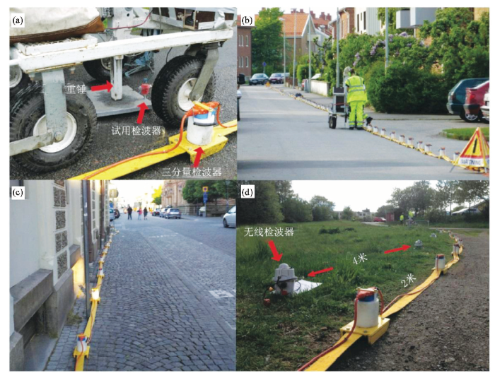
图1
陆上地震拖缆野外作业照片[19]
a—安装在拖缆上面的检波器;b—城市调查现场和地面条件的实例1;c—城市调查现场和地面条件的实例2; d—单分量无线检波器与三分量拖缆单元(可获取更长的偏移距,并克服某些复杂的城市环境问题,如道路交叉)
而通过陆上拖缆系统进行P波与面波勘探仍需进一步研究。作为一种新型的城市浅层地震勘探工具,目前陆上地震拖缆所面对的挑战还比较多,包括:背景噪声高、检波器交叉干扰、检波器定向不准、机械磨损以及需要躲避车辆等。一般认为,其存在的主要问题是,在快速移动测量过程中难以使传感器与地面之间始终保持紧密贴合的状态,这可能会影响到测量结果的准确性。
2.2 数据采集
2.2.1 无线地震采集技术
在城市环境中开展浅层地震勘探,布线是比较困难的。采用无线网络替代传统地震仪的传输电缆,不仅可以保证人员和设备安全,而且使浅层地震数据采集变得相对更容易,同时还能提高工作效率及数据的可靠性。现在国际上已经有一些商业化产品,例如地球空间技术公司(GEO SPACE)的GSX系统,目前在市场上具有一定知名度;而Wireless Seismic公司的RT System 2,也号称取得了革命性突破,它采用下一代的无线网络技术,可支持15万道地震数据采集。无线地震采集方法在城市地震勘探中已得到了许多应用。例如Sirles等在美国科罗拉多州格伦伍德·斯普林斯(Glenwood Springs)市横跨科罗拉多河的格兰德大道大桥下附近采用无线地震检波器,开展了三维(3D)浅层地震数据采集。瑞典Uppsala大学采用无线地震检波器,与三分量陆上地震拖缆系统的测量结果进行了对比分析[22]。尽管城市环境对无线网络的干扰比较大,在实际应用中还存在着一些问题[23]。然而,随着现代信息技术的飞速发展,通过融入新技术,实现方法创新,从而提高地震数据采集效率,已经是今后发展的必然趋势。
2.2.2 伪随机扫描方法
在可控震源线性扫描时,周围建筑物会产生谐振效应(典型扫频为6100 Hz),因而可能出现建筑物发生毁坏的后果。而伪随机扫描经过优化设计后,可以有效减少这种谐振效应,从而降低建筑物受到破坏的可能性;此外,还具有优越的正交性及可增强低频成分等优点[24]。尽管业内早就认识到该方法的重要性[25-26],但在实际应用中的效果并不理想。近年来,由于对扫描中的低频部分开始重视,从而对非线性扫描重新产生了兴趣,如何根据实际需求,对优化伪随机扫描进行优化设计,就成为国内外可控震源勘探研究中的一个重要领域。如Scholtz等[27]针对有建筑物覆盖区开展的浅层地震勘探,在伪随机扫描优化时,通过去相关与褶积运算处理,极大地降低了质点峰值振动速度(PPV),而保持了与线性扫描记录相似的地震数据质量。因此伪随机扫描技术特别适合于城市环境勘探,未来潜力比较大。
2.2.3 其他方法
随着地震勘探数据信息量的日渐增加,如何提高工作效率也成为近年来业界十分关心的话题。近年来,通过优化方法,压缩地震采集量成为一个新的热点和前沿。Baraniuk等[28]就综述了压缩传感(CS)技术在地震数据采集与处理中的应用,其核心思想是改变传统的采集方式,提高数据质量,以减少后期处理的工作量。在城市浅层地震勘探中,也可吸收这方面的先进成果和经验。
2.3 数据处理
2.3.1 与航空物探数据联合反演
为了克服地震勘探的不确定性或多解性,地震同步联合反演或综合其他地球物理方法常常可以取得更好的效果[9]。因为地震勘探方法具有精度相对较高的特点,而结合非地震方法可以减少地震走时的不确定性影响。近年来,人们越来越重视通过航空物探与地面地震勘探开展联合反演,这样既充分利用了航空物探覆盖范围广、可查明地下三维结构特征的优点,又能够弥补地震勘探的缺点。如Høyer等[29]综合使用航空TEM与地面地震勘探方法,查明了丹麦日德兰半岛西部某地第四系与新近系沉积地层特征,为该地区进一步勘查地下水提供了重要信息。Colombo等[30]通过地震勘探与航空TEM相结合,获得了沙特阿拉伯某地区高分辨率的近地表速度模型,从而有效地克服了地震层析成像的问题,结果为地下浅层特征描述提供了更全面的依据。当然,联合反演必然会增加勘探的成本,故需要综合考虑。
2.3.2 利用瑞雷面波约束P波层析成像
在传统地震勘探中,常用P波作为主要勘探手段。由于地下浅层介质的侧向属性变化快,而P波又是水平传播的,由此导致P波折射法在浅层的分辨率都比较低。最近Duret等[9]提出了一种新方法,通过瑞雷波辅助P波折射数据进行层析成像,以改进P波近地表速度模型,即对近地表的速度进行了模拟。为验证其有效性,以一条宽阔而蜿蜒的河流上获得的窄方位地震数据为例,该河床两侧的P波速度变化很大,尤其是未固结的沉积物的波速较低,而周围山地已固结沉积物的波速都较大。因此,需要将由瑞雷波反演得到的近地表S波速度信息对P波成像结果加以约束,以便改善所得图像的质量。结果发现,近地表原来较薄的地层确实变得更加清晰而且相对更连续(图2)。由此可见,非传统(面波)地震勘探方法与常规(P波)地震勘探方法相结合,有可能取得出人意料的良好效果。
图2
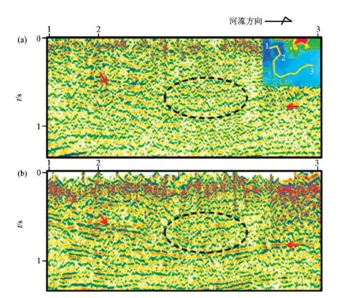
图2
沿着某条河流(右上框中的河道123)的地震叠加剖面示意[9]
a—采用标准的、未经约束的P波折射速度模型;b—采用新的有约束的P波折射速度模型。可以看出,在椭圆形中的薄层的侧向连续性增强,同时红色箭头所指示的“周期跳跃”现象问题也能消除
2.3.3 其他方法
此外,一般地震数据的处理工作量都十分庞大,费时费力,因此有研究者提出了一些自动化处理方法。如Colombo等[31]提出了一种用于地形起伏不大地区的近地表自动分析方法(pQC),该方法不仅可以改善地表一致性静校正误差,获取可靠的初至波拾取时间和折射层速度;更重要的是,该过程是完全自动化的,可显著减少地震数据分析的时间,从而提高了效率。
最后,在城市地下空间探测过程中,由于地质条件与人为因素混合在一起,模拟结果与实际情况之间往往存在着偏差,因而有必要对地震速度模型的不确定性进行评价。尽管目前城市浅层地震勘探技术已经取得了很大进步,但对结果的不确定性评价也成为对地下特征进行描述的一个重要部分。近年来有关地下特征描述的不确定性评估的方法也越来越完善[32]。除了经验性方法以外,还应当根据城市环境的具体特点,添加城市地质合理性约束条件。例如可以从工程师、管理人员等其他知情人士那里了解更多的实际信息,以便评价非唯一解的多种可能性,以进一步增加地震勘探资料的价值。在实践中,首先要对引起不确定性的问题进行识别,并具体分析其原因;然后为了便于处理,对那些不确定性因素进行量化也是很有用的。
2.4 解释应用
2.4.1 城市噪声面波技术应用案例
近年来在城市噪声面波技术的应用研究中已取得了明显的进展。主要表现在:一是利用单一噪声作为震源取得效果。例如美国勘萨斯地调局的Ivanov等[37]利用该州哈钦森市(Hutchinson)火车通过时的振动作为被动震源,通过面波多道分析方法(MASW),经过试验,较为成功地获取了该市地下S波的速度信息,进而对深部岩溶洞穴的分布进行了评估,为建筑场址选择提供了依据。那里由于地下岩溶塌陷,对城市造成很大影响,但因其深度较大,最多可达120 m,常用地面物探方法很难发挥什么作用。根据该项研究得到的S波速率,可以推断出岩石应力状态,进而判断其发生破裂的可能性。
图3
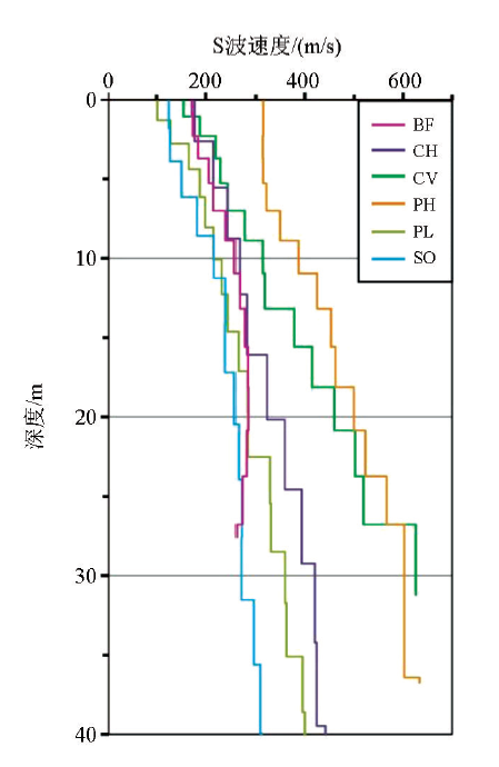
图3
在6个勘探点的S波速度剖面[38]
注:BF仅上部15 m的S波速度变化与其他5个地点一致,但再往下则无变化,推测可能系填充物所致;PH、CV两处为基岩,在20 m深时S波最大速度可达285 m/s
三是利用微动台阵网络,通过连续监测获取大量数据,以保证勘查结果的可靠性。比如日本的Nakata[16]在关东地区群马县(Gunma)通过300个单分量(1C)检波器采集了环境噪声(特别是交通噪声)数据,经过双波束成形法与地震干涉法分别处理,运用多通道面波分析方法(MASW)估算出了近地表的二维S波速度。其原理是,面波的频散特征与地下弹性波(尤其是S波)速度的空间变化密切相关。双波束成形法可以从环境噪声中提取出高信噪比的面波数据。由于作者使用的检波器的水平分量垂直于勘探线方面,所提取出的面波主要为勒夫波。因此,如果还有检波器的其他分量,瑞雷波也可采用类似的方法。该二维S波速度模型可以反映地下80 m以浅的详细信息。作者使用的是连续12小时的交通噪声数据,但他认为,即使只用1小时的噪声数据,也能得到类似的速度模型(图4)。由于面波勘探一般仅考虑瑞雷波,该案例也给我们展示了勒夫波的应用潜力。
图4
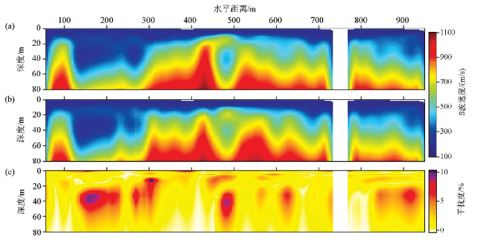
图4
关东地区群马县(Gunma)300个单分量(1C)检波器获取的环境噪声数据反演地下S波速度信息[16]
a—由12个小时的面波频散曲线反演得出的S波速度;b—只用1个小时的交通噪声数据反演得出的S波速度;c—每小时S波速度的差异对比
因此,当有足够丰富的城市噪声可作来震源来使用时,既能获得对描述城市浅层地质特征有重要意义的大量信息,又能满足城市环境对绿色、环保震源的需求。故城市噪声面波技术在城市地质调查中具有良好的发展前景和巨大的空间。
2.4.2 陆上地震拖缆系统应用案例
现阶段,陆上地震拖缆系统的工作模式主要为S波。对于P波也曾经作过探讨,但研究报道不多。而面波则还没有。
图5
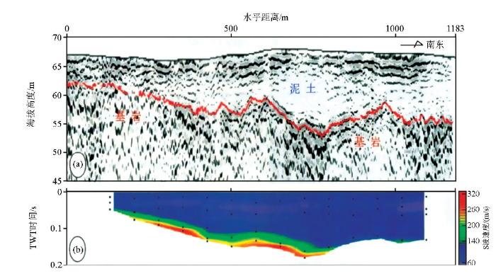
图5
渥太华市长达1 183 m的S波速度剖面示意[5]
a—根据地形起伏情况进行处理后的时间剖面;b—层速度函数(用等高线表示)(黑点代表平均速度与时间对)
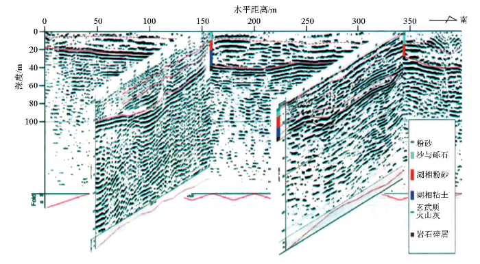
在欧洲,Krawczyk等[6]利用LIAG研发的地震拖缆系统,分别在德国的Gillenfeld与Hamburg及挪威的Trondheim地区开展了调查,测量水平极化S波,都得到了高精度的速度结果。例如 Gillenfeld地区近地表为第四纪河湖相沉积物,深度约6080 m,测量结果很好地揭示了地下深部沉积物的结构与分层特征(图6),其南北向展布与另外方向的展布特征完全一致,而且被附近的钻孔解释资料所证实。该剖面的垂直精度约为2 m。而Hamburg地区由于岩溶塌陷,发育地下陷坑,因此对探测精度要求更高,在测量时采用更小的炮间距,对该地区地下100 m以内的地层结构进行详细成像,结果在60100 m之间发现了一个很大的碗状的塌陷构造。尽管测量是在白天进行的,但其数据质量与信噪比都很高,地下图像的精度水平可达510 m,而垂直方向甚至达到1 m。在挪威的Trondheim地区则采用MHV4S微震动器作为震源,探测深度达到200 m,垂直分辨率约为1~5 m。
图6
3 结论与展望
通过瑞雷波约束折射P波层析成像结果或联合反演方法,可以提高后者对城市地下“百米”空间的探测精度。然而更加直接的方法还有面波和S波技术。一是当有足够丰富的城市噪声可作为震源来使用时,既能获得对描述浅层地质特征有补充意义的重要信息,同时又满足了城市环境对绿色、环保震源的要求;二是随着重要仪器设备的发展,尤其是陆上地震拖缆系统的研发和完善,使得S波技术在地下浅层勘探中也成为一种很有价值的工具。此外,引入先进的现代信息技术(无线网络),改进可控震源伪随机扫描方法,也进一步提高了城市浅层地震勘探技术的适用性、针对性及数据采集效率。
由于陆上地震拖缆系统不仅可测量P波,还能测量S波与面波。而面波信号通常比体波信号强度要高出一个数量级,这表明陆上拖缆更适用于测量面波。因而,该系统具有巨大的发展前景。在数据采集方面,现代信息技术的引入,有利于提高地震数据采集效率。在数据处理方面,通过航空物探与地面地震相结合进行联合反演,可同时满足对勘探精度与勘探范围的要求,必将越来越受到人们的欢迎。同时,与各种新型大型仪器设备配套的算法软件的开发,也使数据集成与综合反演能力大大增强。
最后,值得一提的是,由于地震波中蕴含着大量丰富而有用的信息,因此人们越来越重视对以往视为干扰波的地震波(包括面波、声波和其他多次波等)的研究,此即非传统地震方法。2017年在欧洲地质学家和工程师协会(EAGE)主办的刊物《Near Surface Geophysics》上以“城市地球物理学”为主题开展了论文征集,其主要内容之一就是对以往需要抑制的干扰波进行重点开发和利用。当前,面波技术的一个前沿领域是城市噪声震源勘探技术,因此今后在面波勘探的基础上,还需要对其他干扰波开展深入的研究和挖掘。
参考文献
在中国地质矿产经济学会2016年工作会议上的讲话
[J].
DOI:10.3969/j.issn.1672-6995.2017.01.003
URL
[本文引用: 1]

正(2016年11月21日)这次会议是中国地质矿产经济学会召开的一次全国地勘行业的重要会议。张少农理事长亲自指导会议的筹备,因有重要工作不能参会,专门向姜大明部长做了报告。姜部长高度重视,委托我来参加会议。借这个机会,我代表部党组、代表姜大明部长,代表张少农理事长,向大家并通过大家向地勘行业广大干部职工表示诚挚的问候!
环境与工程地球物理的发展趋势
[J].
DOI:10.3969/j.issn.1004-2903.2006.02.041
URL
2006年6月在武汉召开了第二届环境与工程地球物理国际会议.会议围绕近年来兴起的近地表探测问题展开,涉及方法原理、仪器采集、资料处理等各个环节,反映出国内外环境与工程探测领域的若干前沿热点和发展动态.结合本次会议,可以看出该学科主要趋势为:应用领域不断扩宽,方法技术灵活多样,重视基础理论研究,开发新型(特种)仪器,通过高精度测量、延时测量、先进的数据处理技术和信息技术等手段改善探测质量.我国对环境与工程地球物理有很大的需要,应根据我国实际情况,吸收国外先进经验,积极开展自主创新.
城市工程地球物理探测技术应用与发展趋势
[J].
DOI:10.3969/j.issn.1672-7940.2008.05.013
URL
近年来,城市工程地球物理探测技术得到了较快发展,并取得良好应用效果。城市工程地球物理探测具有很多特点,地面探测方法、地球物理测试方法、水声探测方法以及井中探测方法等各有所长,可以为岩土工程、地质灾害防治和环境问题研究提供有益的信息和数据,在实际应用中具有明显的技术优势。在实际中应该注重应用条件适应性、开展方法试验和综合物探。结合实际加强技术方法、仪器设备等方面的研究,将会推进城市工程地球物理探测技术得到更广泛应用与发展。
Shear-wave high-resolution seismic reflection in Ottawa and Quebec City,Canada
[J].
DOI:10.1190/tle32030250.1
URL
[本文引用: 4]
Two examples of multicomponent shear (S)-wave, shallow, seismic reflection profiling from urban en-vironments in eastern Canada are presented to examine the benefits of shear-wave reflection data and the latest developments in acquisition methodology, as well as our evolving understanding of the complex nature of seismic-wave propagation. In "soft" soils characterized by low shear-wave velocities, high-resolution shear-wave reflection sections can be obtained, with the highest-resolution data related to horizontal or vertical components of motion. Multicomponent recording provides the capacity to record valuable shear-wave velocity information for earthquake amplification and engi-neering investigations in urban environments.
Shear-wave reflection seismics as a valuable tool for near-surface urban applications
[J].
DOI:10.1190/tle32030256.1
URL
[本文引用: 7]
Subsurface investigations in urban areas have to take sealed surfaces and densely built and populated areas into account. The shear-wave reflection seismic system developed at the Leibniz Institute for Applied Geophysics (LIAG) provides a solution for this acquisition technology problem using horizontally polarized shear waves (SH-waves) and noninvasive source and receiver designs.
Seismic reflection imaging of a geothermal aquifer in an urban setting
[J].
DOI:10.1190/1.1444430
URL
[本文引用: 1]
A seismic reflection survey that was conducted in downtown Boise, Idaho, to help city planners site a new well for injection of spent geothermal water illustrates some methods to safely and successfully employ a seismic reflection survey in an urban setting. The objective of the seismic survey was to estimate the depth and continuity of a basalt and rhyolite volcanic sequence. Well siting was based on geothermal aquifer depth, location of interpreted faults, projected thermal impact of injection on existing wells, surface pipe extension costs, and public land availability. Seismic acquisition tests and careful processing were used to ensure high-quality data while minimizing the potential for damage along city streets. A video camera placed in a sewer and a blast vibration monitor were used to confirm that energy from the seismic source (a 75-in3 land air gun) did not damage nearby buildings, street surfaces, or buried utilities along the survey lines. Walkaway seismic tests were also used to compare signal quality of the air-gun source to an explosive source for imaging targets up to 800 m depth. These tests show less signal bandwidth from the air-gun source compared to the buried explosive source, but the air-gun signal quality was adequate to meet imaging objectives.Seismic reflection results show that the top of this rhyolite/basalt sequence dips (~8-11 ) southwest away from the Boise foothills at depths of 200 to 800 m. Seismic methods enabled interpretation of aquifer depths along the profiles and located fault zones where injected water may encounter fracture permeability and optimally benefit the existing producing system. The acquisition and processing techniques used to locate the Boise injection well may succeed for other hydrogeologic and environmental studies in urban settings.
Urban seismic site investigations for a new metro in central Copenhagen:Near-surface imaging using reflection,refraction and VSP methods
[J].
Near-surface velocity modeling using a combined inversion of surface and refracted P-waves
[J].
DOI:10.1190/tle35110946.1
URL
[本文引用: 4]
We propose an innovative workflow based on the complementary use of Rayleigh waves alongside standard P-wave refraction tomography, which better depicts the shallow part of the near-surface P-wave velocity model. Our surface-wave processing sequence led to an S-wave near-surface velocity field that can be used as a constraint for P-wave tomography and can improve P-wave statics determination. Rayleigh waves are processed in three steps. The first step consists of an accurate frequency-dependent traveltime measurement for each selected source-receiver pair in which the phase difference between two adjacent traces is used to derive the phase velocity. Then, a frequency-dependent surface-wave velocity tomography is performed from the picked traveltimes. Finally, after surface-wave tomography, the frequency-dependent phase velocity volume output by the tomography is inverted to deliver an S-wave near-surface velocity model. This model is used to constrain the first-arrival P-wave tomography. To illustrate our method, we use a 3D narrow-azimuth land data set, acquired along a river valley. Strong lateral velocity variations exist in the shallow part, with slow velocities around the unconsolidated sediments of the riverbed and faster velocities in the consolidated sediments of the surrounding hills. A combined first-arrival tomography using the S-wave velocity model, the initial unconstrained refracted P-wave velocity model, and the original first arrivals is used to obtain a more accurate near-surface P-wave velocity model. This new approach led to a constrained P-wave velocity model from which primary statics are derived and then applied, leading to an improved image with better focusing and continuity of thin layers in the shallowest part.
An overview of full-waveform inversion in exploration geophysics
[J].
High-resolution velocity modeling by seismic-airborne TEM joint inversion:A new perspective for near-surface characterization
[J].DOI:10.1190/tle35110977.1 URL [本文引用: 1]
An introduction to this special section:Applications and challenges in shear-wave exploration
[J].
DOI:10.1190/tle32010012.1
URL
[本文引用: 1]
Shear-wave (S-wave) technology has been investigated for about half as long as P-waves as an exploration tool, beginning in the mid-1960s with field experiments and vertical seismic profiles (VSP) to assist interpretation. Although it was immediately recognized that the relative quality of S-wave data was unpredictable, early processing and analysis did not consider the effects of birefringence or splitting. This unpredictable behavior, along with dynamic mis-ties, observed at intersections of 2D lines, was shown in the 1980s to be a result of S-wave splitting in azimuthally anisotropic media. In addition, 20 years of the early effort were devoted to developing S-wave sources. However, ironically, it turned out that conventional P-wave sources were best; P-waves convert to S-wave (PS-wave) reflections at layer interfaces with nearly the same strength as P-wave reflections.
Near-surface geophysical techniques for geohazards investigations: Some Canadian examples
[J].
DOI:10.1190/1.3480011
URL
[本文引用: 1]
Abstract Over the last 40 years, there has been an expansion of activity in applications of near-surface geophysical techniques for various types of geohazards investigations in Canada; numerous national and international research groups have been working with the Near Surface Geophysics Section of the Geological Survey of Canada to develop techniques for specific Canadian engineering and environmental geohazards problems. A few of the more interesting examples from widespread parts of the country are discussed in this paper.
Near-surface S-wave velocities estimated from traffic-induced Love waves using seismic interferometry with double beamforming
[J].
U051/U051-025
A state-of-the-art MEMs-based 3C Seismic Landstreamer for Various Near-surface Applications
[C]//
Near-surface mapping using SH-wave and P-wave seismic land-streamer data acquisition in Illinois,U.S
.[J].DOI:10.1190/1.1776740 URL [本文引用: 1]
Multicomponent high-resolution seismic reflection profling
[J].DOI:10.1190/1.3249782 URL [本文引用: 1]
Multicomponent broadband digital-based seismic landstreamer for near-surface applications
[J].
DOI:10.1016/j.jappgeo.2015.10.009
URL
[本文引用: 2]
61A three component MEMS-based seismic landstreamer was developed61Combination with wireless units enables data acquisition in inaccessible areas61Tests show the potential of the system for urban and high-resolution studies61A challenging location from the planned Stockholm Bypass was chosen as a test site61Tomography results show low velocities correspond well to zone of poor quality rock
The use of pseudo-random sweeps for vibroseis surveys
[J].
DOI:10.1111/1365-2478.12074
URL
[本文引用: 1]
Pseudorandom vibroseis sweeps have long been suggested as an alternative to standard linear sweeps due to their potential for having superior orthogonality, a lower likelihood for infrastructure damage, and increased low-frequency content. In the past, they were also attractive as they have a better autocorrelation shape, although that is less important today. Their use has been limited but the increasing popularity of simultaneous acquisition techniques has rekindled interest as they offer the ability to reduce interference noise. A wide variety of methods for generating pseudorandom sweeps have been developed over the last 45 years. This paper gives an overview of the motivations for their use before classifying and describing the different sweep types. Finally, the sweeps will be compared in terms of their major attributes including their suitability for simultaneous surveys.
Some alternative vibrator signals
[J].DOI:10.1190/1.1440947 URL [本文引用: 1]
Numerical modelling of pseudo-random seismic sources
[D].
Pseudo-random sweeps for built-up area seismic surveys
[J].
DOI:10.1190/tle32030276.1
URL
[本文引用: 1]
Abstract Optimized pseudo-random sequences proved effective, both theoretically and empirically, in increasing data quality while reducing possible damage to buildings by vibratory sources during seismic reflection data acquisition. The linear sweeps commonly used for vibratory measurements can cause resonance in nearby infrastructure; hence, there is a potential for property damage. A pseudo-random sweep signal can be designed to decrease resonance effects and therefore reduce damage thresholds. The sweep sequences produced by simple random number generators, like the ones given by the vibrator manufacturers, have marked disadvantages, such as high correlation noise, large fluctuations in spectral amplitudes, and reduced seismic energy. To overcome some of these problems, an optimization process can be developed to produce pseudo-random sweeps for site-specific conditions. Two strategies are considered for preprocessing: crosscorrelation and deterministic deconvolution. Analysis of examples for an optimum pseudo-random sweep and simple pseudo-random sweep demonstrates that the total seismic energy is increased, while side-lobe energy is decreased and spectral fluctuations are reduced when the pseudo-random sweep is optimized. A limited-scope field test reveals that the peak particle velocity values are lowered substantially, while correlated and deconvolved records generated by the optimized pseudo-random sweep are of similar quality to a linear-sweep record. Application of optimized pseudo-random sweeps has the potential to increase productivity, while maintaining data quality and reducing resonance in surveys of built-up areas.
Steeghs P.Compressive sensing:A new approach to seismic data acquisition
[J]. 645 .
645 .
DOI:10.1190/tle36080642.1
URL
[本文引用: 1]
AbstractSensing and imaging systems are under increasing pressure to accommodate ever-larger and higher-dimensional data sets; ever-faster capture, sampling, and processing rates; ever-lower power consumption; ever-smaller form factor; and new sensing modalities. These needs have motivated the development of new approaches to signal acquisition and processing. We provide an introduction to the field of compressive sensing (CS), which has stimulated a rethinking of sensor and signal processing system design. In CS, analog signals are digitized and processed not via uniform sampling but via measurements using more general, even random, test functions. In contrast to conventional wisdom, the new theory asserts that one can combine “sub-Nyquist rate sampling” with large-scale optimization for efficient and accurate signal acquisition when the signal has a sparse structure. Particular topics addressed include signal sparsity, randomized sampling, optimization-based signal recovery, and perspectives on applications to seismic data acquisition and processing.
Combined interpretation of SkyTEM and high-resolution seismic data
[J].
DOI:10.1016/j.pce.2011.01.001
URL
[本文引用: 1]
Airborne electromagnetic methods (AEM) are used extensively in groundwater investigations, often in combination with high-resolution seismic data. Despite the frequent use of this mapping strategy, only a few cases are found in the literature. In this study, comparisons and interpretations were made based on AEM (SkyTEM) and high-resolution seismic data from an area covering 10 km 2 in the western part of Denmark. As support for the interpretations, an exploration well was drilled to provide lithological and logging information in the form of resistivity and vertical seismic profiling. Based on the resistivity log, synthetic SkyTEM responses were calculated with a varying number of gate-times in order to illustrate the effect of the noise-level. At the exploration well geophysical data were compared to the lithological log; in general there is good agreement. The same tendency was recognised when SkyTEM results from the area were superposed onto seismic sections. Comprehensive geological knowledge is necessary in order to introduce layer boundaries from one method interactively in the data handling of the other. However, in cases where resistivity transitions are positively correlated to reflections, SkyTEM data supports the interpretation of weak reflections, and can also support the correlation of reflections both internally and between seismic lines. Besides contributing lithological information, the AEM survey provides gross three-dimensional structural information, whereas seismic data contributes with more detailed structural information in two dimensions.
McNeice G,Rovetta D,et al.High-resolution velocity modeling by seismic-airborne TEM joint inversion:A new perspective for near-surface characterization
[J].DOI:10.1190/tle35110977.1 URL [本文引用: 1]
pQC:A novel approach for robust automatic near-surface analysis in low-relief geology
[J].
DOI:10.1190/tle35110952.1
URL
[本文引用: 1]
A novel approach, named pQC, was developed to automatically derive near-surface velocities and statics by applying surface-consistent analysis to refraction data, where the data consist of first-break (FB) traveltimes and early-arrival waveforms. This approach is facilitated by the introduction of a new sorting domain in which FB traveltimes and traces are organized in a multidimensional space consisting of a common-midpoint (CMP) location, offset, and azimuth, called the XYOA domain. The FB traveltime data sorted in this domain can be analyzed efficiently with statistical methods to obtain localized average depth domain velocity trends for calculation of long-wavelength statics. Short-wavelength (residual) refraction statics are then calculated based on the cross correlation of early-arrival waveforms in the XYOA gathers over multiple offset classes and inverted for surface-consistent source and receiver corrections. The application of the combined statics solution to the traces enhances the continuity and power of the stacked reflected events without the need to perform tomography. Surface-consistent analysis of refraction data in the XYOA domain is fully automatic, provides robust solutions for noisy data, and enhances subsequent reflection residual statics calculations. This method can also be exploited for quality-control analysis of FB picks and for automating, in an iterative procedure, the picking of large 3D seismic data sets. The method is demonstrated on a 3D land survey over complex geology where the novel refraction surface-consistent solution enhances the imaging results and employs a fraction of the time needed by a typical tomographic workflow.
Introduction to this special section:Velocity-model uncertainty
[J].
DOI:10.1190/tle36020126.1
URL
[本文引用: 1]
Geophysical characterization of the subsurface is an integral part of the industry9s effort to decrease ambiguity during exploration, development, and production. Over several decades, advances in geophysical technology (e.g., 3D seismic, AVO, depth imaging, 4D seismic, wide/full azimuth acquisition, etc.) have allowed geophysicists to routinely produce more accurate “best technical case” images of the subsurface. Given the impressive nature of these advances, our nongeophysical colleagues might be tempted to think that geophysicists have eliminated uncertainty from our subsurface images. Nothing could be further from the truth. Most (if not all) of the time, geophysical characterization of the subsurface involves estimating solutions to ill-posed inverse problems. This ill-posedness stems from a variety of sources, including insufficient measurements and physical phenomena like seismic anisotropy.
Measurement of shallow shear wave velocities at a rock site using the ReMi technique
[J].
DOI:10.1016/j.soildyn.2007.08.005
URL
[本文引用: 1]
Shallow shear wave velocities beneath a rock site are characterized using the refraction microtremor (ReMi) technique developed by Louie [Faster, better: shear-wave velocity to 10002m depth from ReMi arrays. Bull Seism Soc Am 2001; 91: 347–64]. Ground motion from a passing train enabled capture of energy propagating parallel to the recording array. This allowed evaluation of the variation of the minimum phase-velocity of the dispersion curve envelope and better estimation of the true minimum velocity beneath the site. We use a new method to image and evaluate the dispersion curve envelope via power–slowness profiles through the slowness–frequency plots introduced by Louie [Faster, better: shear-wave velocity to 10002m depth from ReMi arrays. Bull Seism Soc Am 2001; 91: 347–64]. Data illustrated the frequency dependency of dispersion curve uncertainties, with greater uncertainty occurring at low frequencies. These uncertainties map directly into uncertainty of the inverted velocity–depth profile. Above 10002m depth velocities are well constrained with 10% variability. Variability is greatly reduced when the energy propagation is along the geophone array. Greater velocity variation is observed below 10002m depth.
Validity of the refraction microtremor (ReMi) method for determining shear wave velocities for different soil types in Egypt
[J].DOI:10.4236/ijg.2011.24056 URL [本文引用: 1]
Evaluating hazards at salt cavern sites using multichannel analysis of surface waves
[J].
DOI:10.1190/tle32030298.1
URL
[本文引用: 1]
Subsidence resulting in sinkholes within dissolution mine fields in and around the city of Hutchinson, Kansas, USA (Figure 1) has been reported for more than 90 years. Salt dissolution and the resulting unpredictable upward migration of the dissolution voids can be observed both in proximity to well bores (dissolution mining, brine disposal, and oil wells; seismic shot holes, etc.) and in areas known to experience natural dissolution with no apparent anthropogenic influences. One potential outcome of the upward migration of these long-inactive dissolution voids in the city of Hutchinson is significant structural damage to facilities, infrastructure, or traffic areas. Monitoring the condition of a void9s roof is key to determining and managing this risk. Drilling is expensive for this investigative application in part because of the number of potential targets. At a depth of approximately 120 m, most surface geophysical methods have neither the sensitivity nor resolution necessary to detect these voids, much less interrogate the roof.
Surface wave surveying for near-surface site characterization in the East San Francisco Bay Area,California
[J].
Delineating structures controlling sandstone-hosted base-metal deposits using high-resolution multicomponent seismic and radio-magnetotelluric methods: a case study from Northern Sweden
[J].DOI:10.1111/1365-2478.12238 URL [本文引用: 1]
