The interpretation and inference of gravity anomaly and the prediction of salt formation prospect in Yanyuan basin
CHEN Ting1(), YAN Di1, YU Zhou1, QU Chen2, RAN Zhong-Yu1, QIU Long-Jun3
1.Geophysical Prospecting Party of SBGMR,Chengdu 610072,China 2.Institute of Geology,CAGS,Beijing 100037,China 3.School of Geophysics and Information Technology, China University of Geosciences(Beijing),Beijing 100083,China
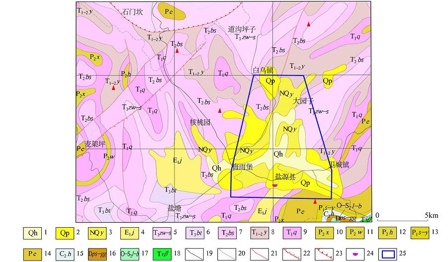
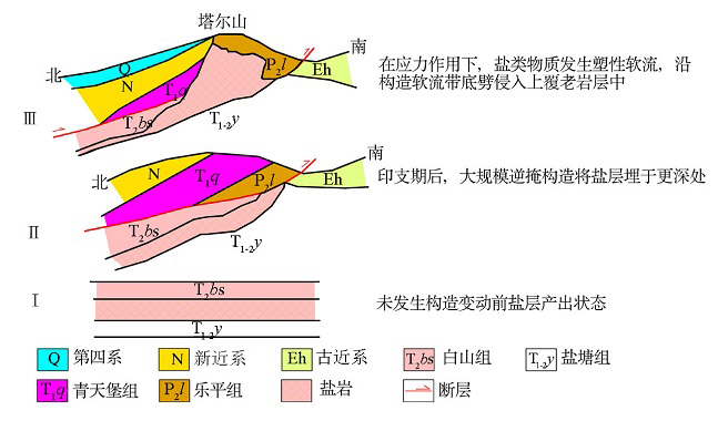
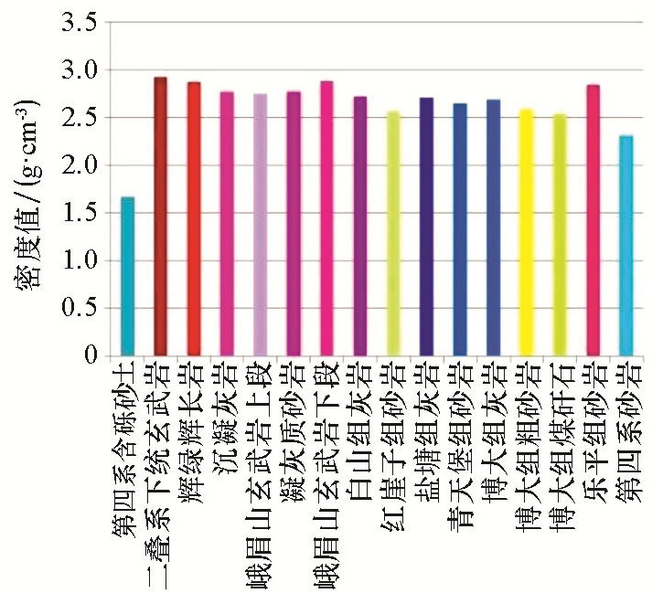
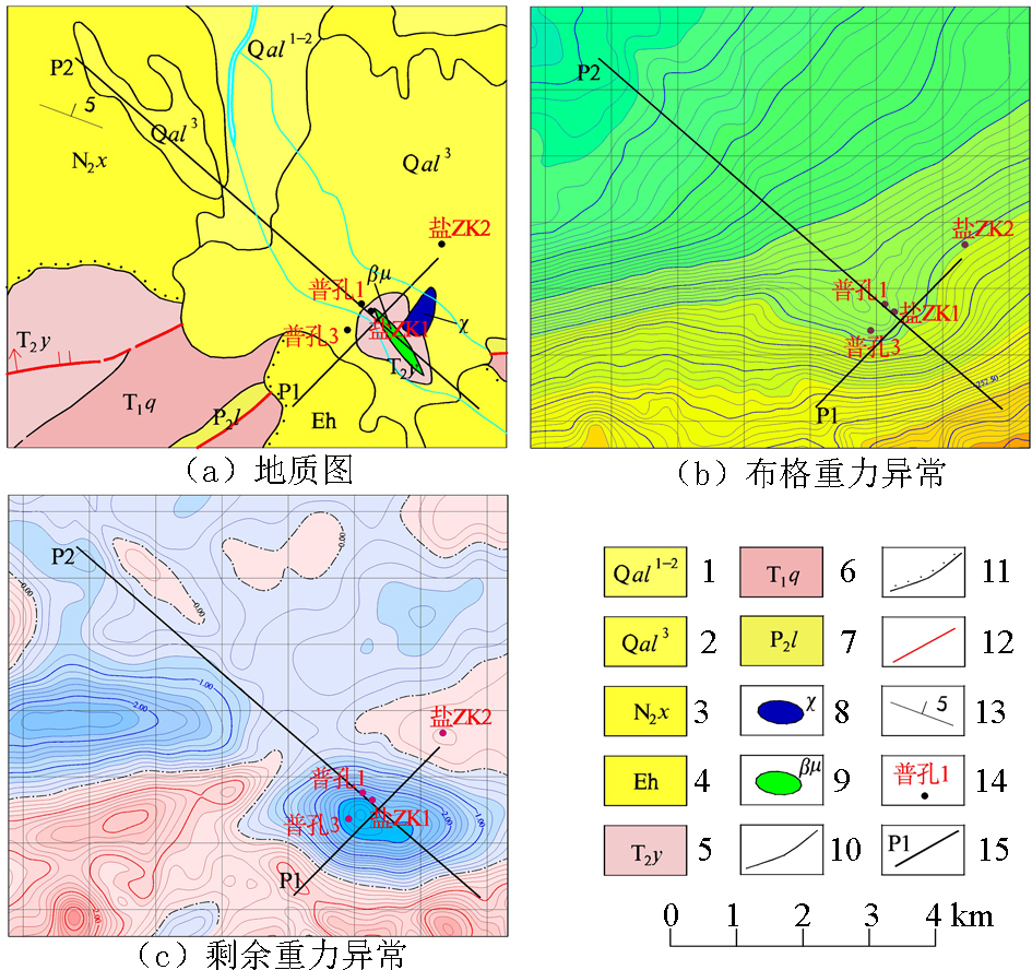
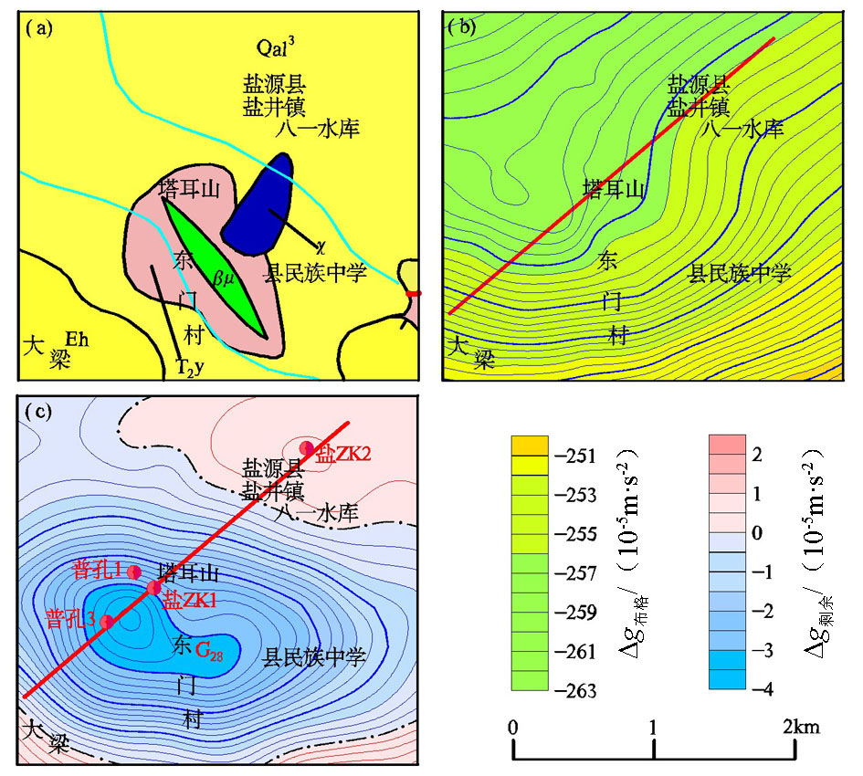
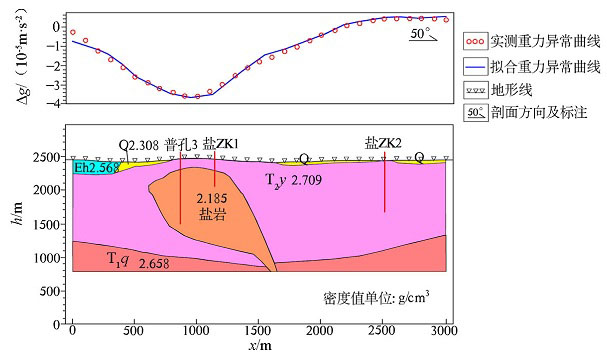
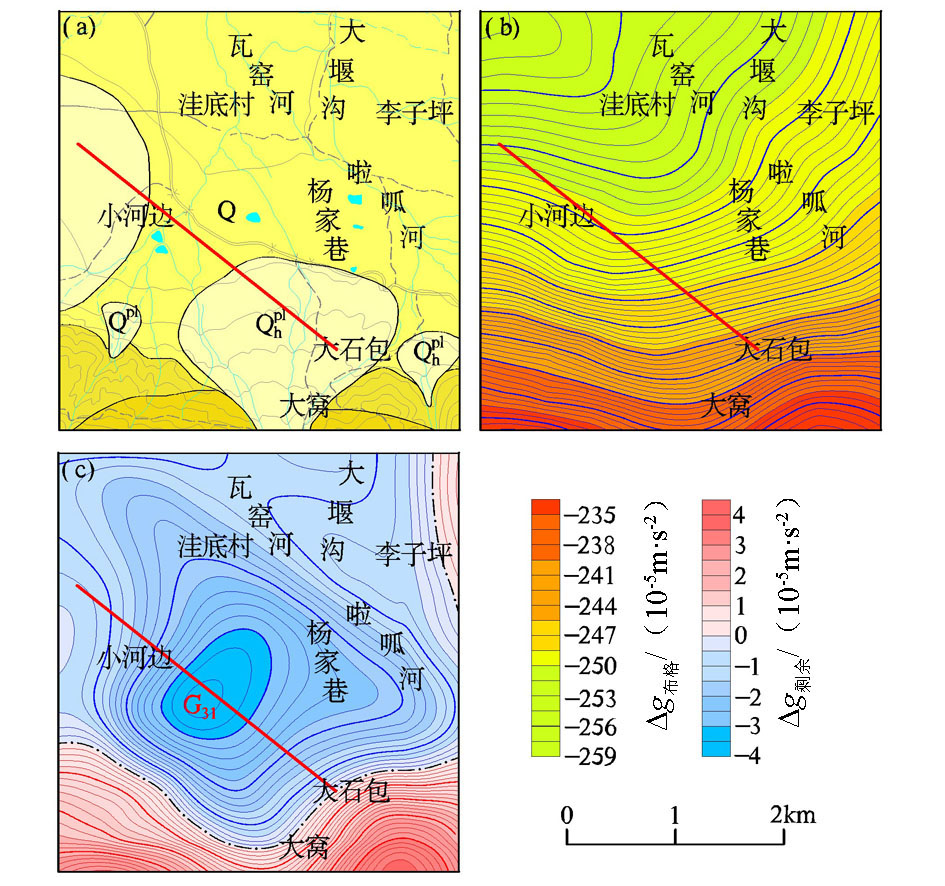
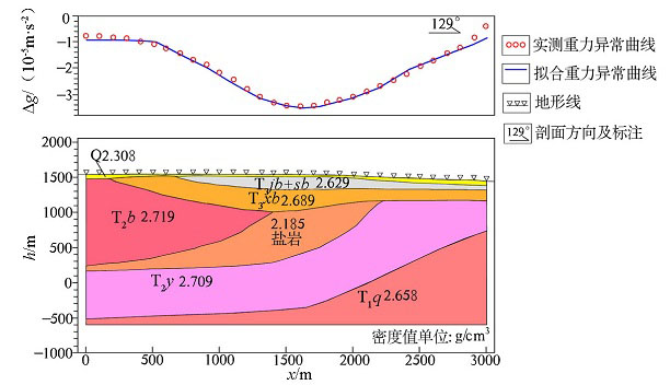
Yanyuan basin is a Cenozoic sedimentary basin in southwest Sichuan basin, where Baishan Formation strata and Yantang Formation strata have rich rock salt. There are four drill holes and a producing well in the salt range of Yanjinggou area, and although the drilling depth of Pu-3 well is 1 001 meters, it does not intersect the salt deposit. The latest 1:50 000 gravimetric data were employed and processed in this paper to build geological-geophysical model of rock-salt minerals by integrating the physical characteristics with gravity anomaly features of rock salt deposit, and a gravimetric profile was simulated by performing the 2.5D forward modelling calculation to infer the geometric and physical parameters of the geological bodies that result in local anomalies. Based on the interpretation of gravity anomalies and the geological understanding of Yanyuan basin, the authors predicted two prospective zones for rock salt exploration in the study area, which has great prospecting significance in Yanyuan basin.
陈挺, 严迪, 余舟, 瞿辰, 冉中禹, 邱隆君. 盐源盆地重力异常解释推断及成盐远景区预测[J]. 物探与化探, 2020, 44(5): 1125-1134.
CHEN Ting, YAN Di, YU Zhou, QU Chen, RAN Zhong-Yu, QIU Long-Jun. The interpretation and inference of gravity anomaly and the prediction of salt formation prospect in Yanyuan basin. Geophysical and Geochemical Exploration, 2020, 44(5): 1125-1134.
Liu J D, Liu W Z. The evolution of Yanyuan basin and the sedimentary environment of the early Triassic Qingtianbao group[J]. Journal of Chengdu Institute of Technology, 1995,22(3):70-74.
[3]
刘鹏. 西昌市、盐源县幅1:25万区域重力调查成果报告[R]. 四川省地勘局物探队, 2015.
[3]
Liu P. Xichang city,Yanyuan county 1:250,000 regional gravity survey results report [R]. Geophysical Prospecting Team of SBGMR, 2015.
[4]
辜学达. 四川省岩石地层[M]. 北京: 中国地质大学出版社, 1997.
[4]
Gu X D. Petrographic strata of Sichuan Province[M]. Beijing: China University of Geosciences Press, 1997.
Li J S, Zheng M P, Jiang Z T, et al. Salt-and potash-forming analysis and forecast of the Yanyuan salt mine in Sichuan Province[J]. Geology and Exploration, 2013,49(4):620-629.
Li J S, Zheng M P, Jiang Z T, et al. Water chemical characteristics of salt spring in Yanyuan of Sichuan Province[J]. Acta Geologica Sinica, 2014,88(9):1762-1770.
[7]
曾云. 四川省成矿区带划分及区域成矿规律[M]. 北京: 科学出版社, 2015.
[7]
Zeng Y. Division of mineralization zones and regional mineralization rules in Sichuan Province[M]. Beijing: Science Press, 2015.
[8]
袁锦. 盐井沟岩盐矿采卤工艺探讨[J]. 中国井矿盐, 1991,100(6):7-12.
[8]
Yuan J. Discussion on brine mining technology in Yanjinggou rock salt mine[J]. Chinese Well Mine Salt, 1991,100(6):7-12.
[9]
范正全. 四川省盐源地区盐矿普查总结报告[R]. 四川省地勘局攀西地质大队, 1987.
[9]
Fan Z Q. Summary report of salt mine survey in salt source area of Sichuan Province [R]. Pan Xi Geological Team of SBGMR, 1987.
Zhang N C, Yan J H, Liu X N. Discuss the deep structure and mineralization of our province from the results of gravity and magnetism[J]. Henan Geology, 1986,4(1):16-22.
[11]
邹俊. 四川省盐源县盐矿物探勘查报告[R]. 四川省地勘局物探队, 2012.
[11]
Zou J. Geophysical survey report of salt mine in Yanyuan county, Sichuan Province [R]. Geophysical Prospecting Team of SBGMR, 2012.
Song X C, Li D R, Tan Y J. Application effect analysis of the gravity methods in the prospecting survey and evaluation of sylvite located in Kuqa depression[J]. Northwestern Geology, 2015,48(3):377-383.
Song X F, Dai D L, Cao T, et al. Application of high precision gravity survey to a rock salt mine in Mongla county,Yunnan province[J]. Contributions to Geology and Mineral Resources Research, 2014,29(3):445-449.
Xin H P. The effectiveness of gravity and electrical sounding in the prospecting for the gypsum deposit[J]. Geophysical and Geochemical Exploration, 1998,12(4):308-311.
Pang C L. The application of gravity data to prediction of potash salt resources in Qaidam basin[J]. Geophysical and Geochemical Exploration, 1987,11(5):348-351.
Yuan W Z, Liu T P, Yuan X C. Ecomposition of gravity field and overpass structure in Qinling-Dabie mountain area[J]. Science in China, 1996,26(S1):7-12.
Wang W Y, Wang Y P, Li J G, et al. Study on the faults structure and granite body distribution in Panggushan area of Yudu-Ganxian ore district using gravity and magnetic data[J]. Geophysical and Geochemical Exploration, 2014,38(4):826-834.
Wang L, Zhang Y W, Liu S G. The application of regional gravity and magnetic data to delineating intrusivie bodies and local geological structures in Guizhou province[J]. Geophysical and Geochemical Exploration, 2009,33(3):245-249.
Zhu Z Q, Cheng Z. Precise inverse interpretation of gravity data from Dongting lake area[J]. Geophysical and Geochemical Exploration, 1996,20(5):393-396.
Sui S W, An Y L, Huang J M. The application of omnibearing imaging system of local gravity magnetic field source under complex conditions in a certain place of Yunnan province[J]. Geophysical and Geochemical Exploration, 2002,26(5):388-391.
Liu W, Shao C S, Li D H, et al. Application of gravity and aeromagnetic data to the study of deep seismogenic environment of the Muli-Yanyuan arc structure belt and its adjacent area in Sichuan,China[J]. Journal of Chengdu University of Technology: Science & Technology Edition, 2018,45(2):250-256.