Please wait a minute...
E-mail Alert Rss
 
物探与化探  2019, Vol. 43 Issue (4): 783-793    DOI: 10.11720/wtyht.2019.0054
     方法研究·信息处理·仪器研制 本期目录 | 过刊浏览 | 高级检索 |
直流电测深法在沿海平原区地质填图中的应用——以苏北盆地连云港灌云地区为例
田少兵, 李向前, 尚通晓, 欧健, 张大莲
江苏省地质调查研究院,江苏 南京 210049
The application of direct-current sounding method in the coastal plains: A case study of Guanyun area in Lianyungang
Shao-Bing TIAN, Xiang-Qian LI, Tong-Xiao SHANG, Jian OU, Da-Lian ZHANG
Geological Survey of Jiangsu Province, Nanjing 210049, China
全文: PDF(14412 KB)   HTML
输出: BibTeX | EndNote (RIS)      
摘要 

以苏北盆地平原区1:5万灌云县、同兴街幅地质填图为例,在研究区内开展面积性电阻率测深勘探,辅以钻探、测井、地质钻孔联合剖面,浅层地震等方法,与电测深方法进行对比分析,突出该方法的经济性与有效性。利用电测深法获得了区内浅地表电性特征,为区内盐碱地的脱盐化提供依据;对区内地下水咸化特征进行了刻画,获得了区内咸淡水分布特征并对区域内淡水资源的利用提供指导;对区域基岩面特征及断裂构造特征进行划分,在区域东南角划分NE向淮阴—响水断裂。通过钻孔验证,认为直流电测深法在平原区地质填图中可以有效弥补钻孔密度的不足,是一种简单有效的勘探方法,值得在平原区地质填图中广泛应用。

服务
把本文推荐给朋友
加入引用管理器
E-mail Alert
RSS
作者相关文章
田少兵
李向前
尚通晓
欧健
张大莲
关键词 平原区填图直流电测深法咸淡水界线苏北盆地淮阴—响水断裂;盐碱地    
Abstract

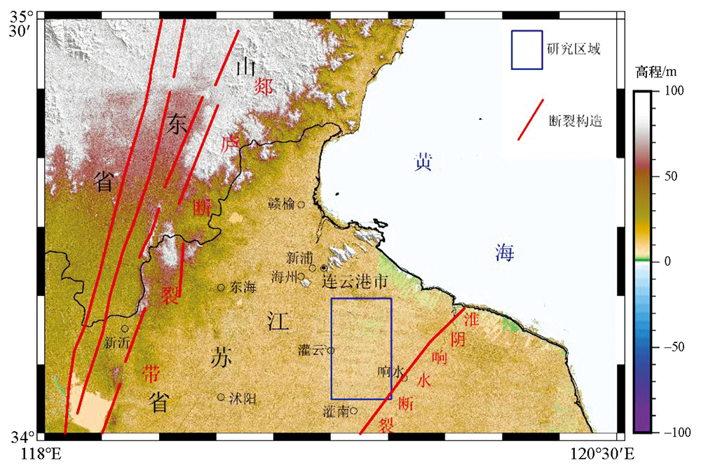
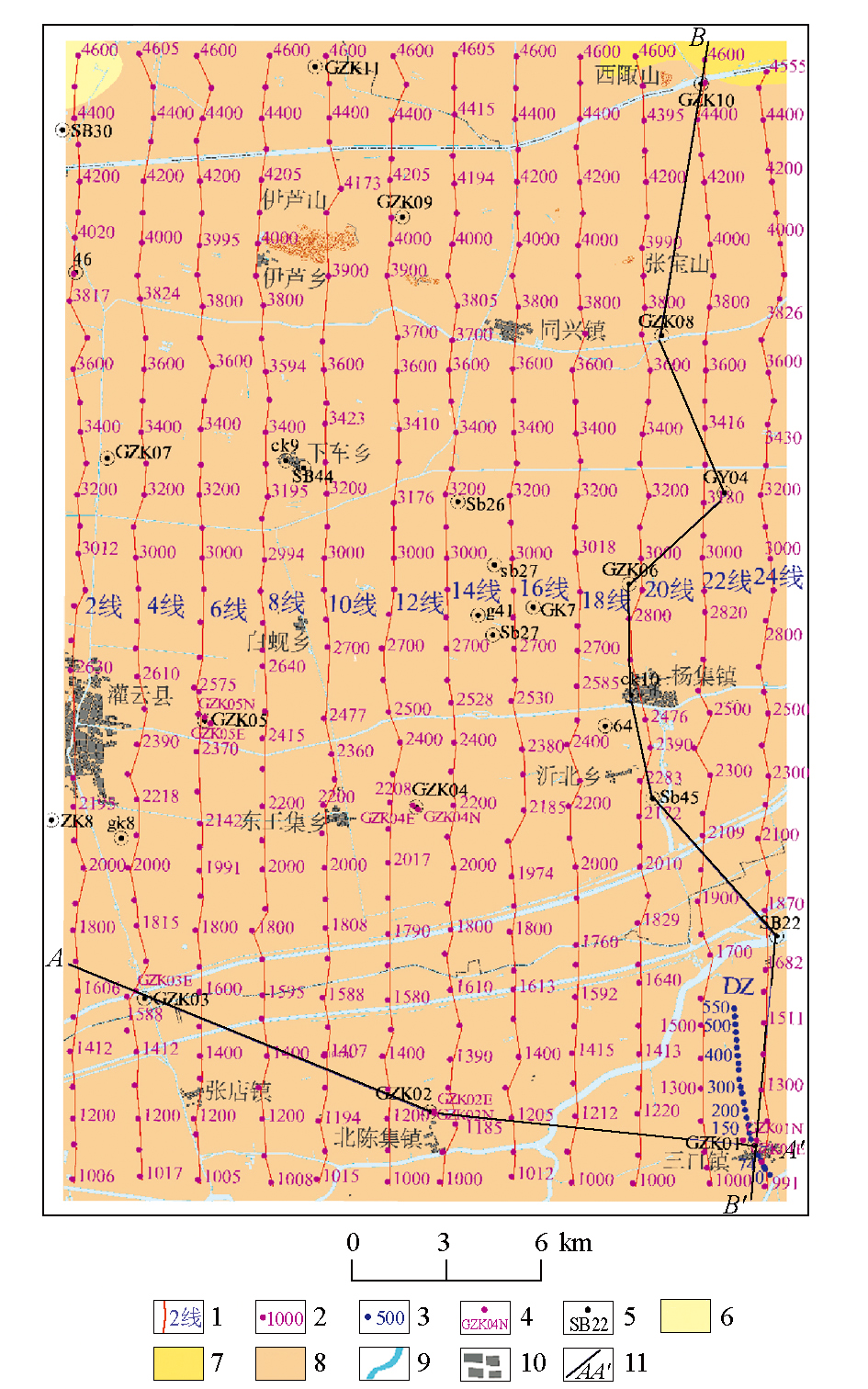
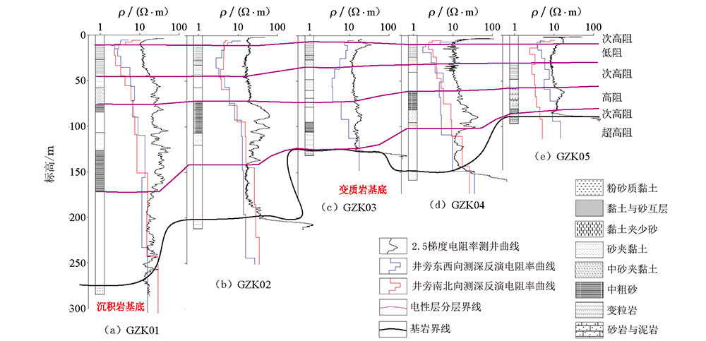
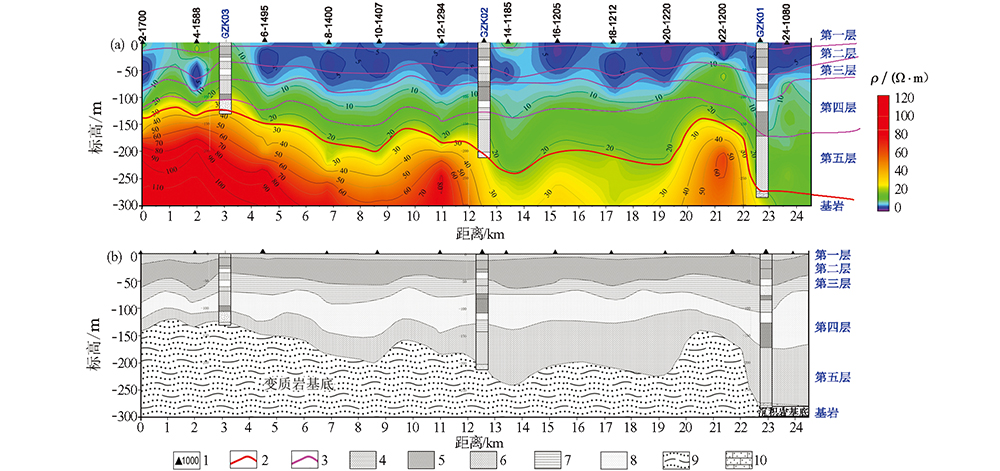
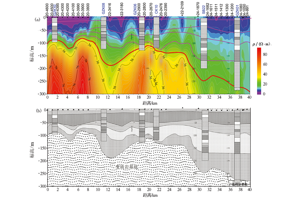
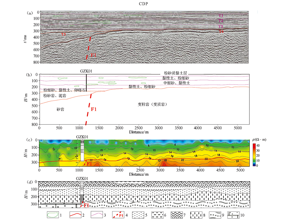
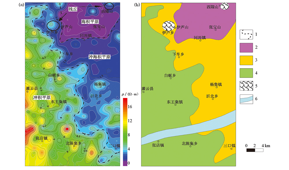
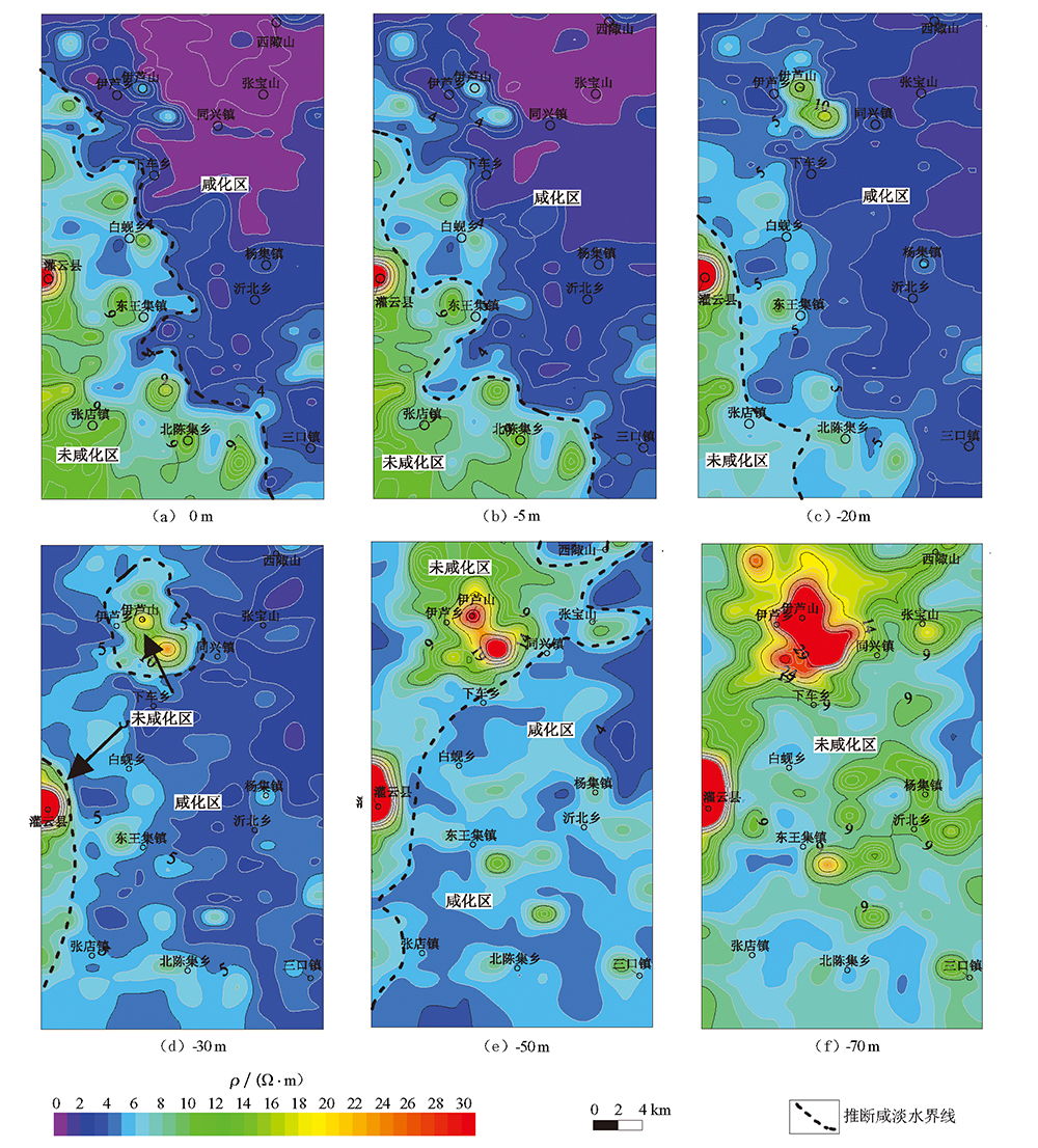
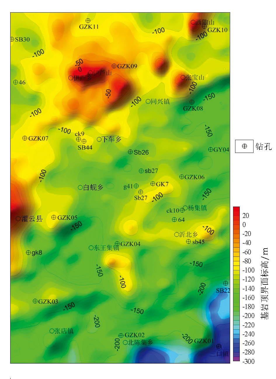
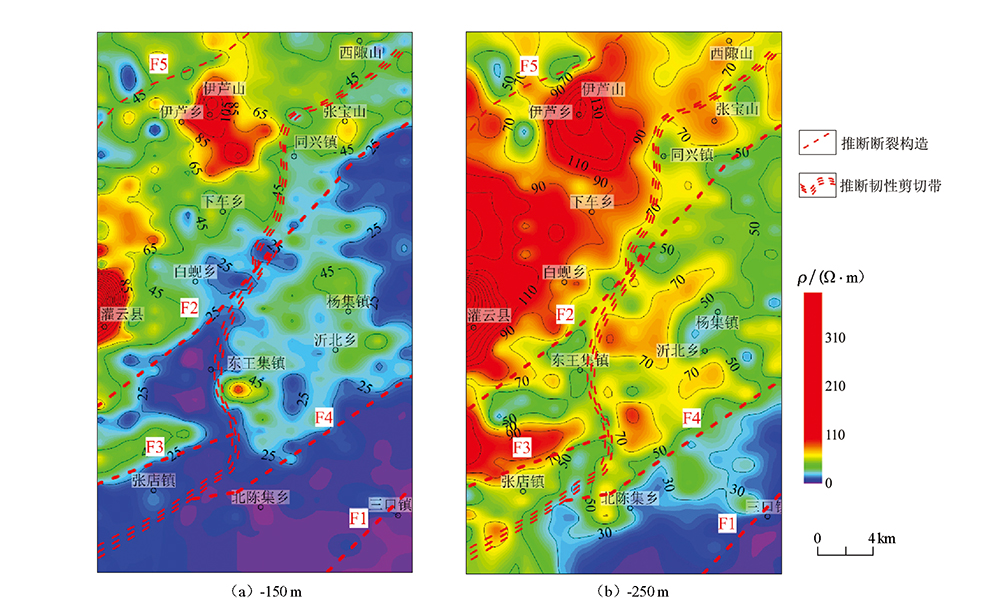
In this study, the authors used direct-current sounding method (DC method) to explore the electrical resistivity property of Guanyun area in northern Jiangsu basin, based on the 1:50000 geological map. In combination with drilling, well-logging, geological combined profile and shallow layer reflection methods, the authors evaluated the economics and effectiveness of the DC method. The authors obtained the geomorphological electric characteristics of the study area based on the DC method,which provided a basis for the desalinization of saline-alkali land in the study area. The authors first obtained the distribution of brackish water in this area based on the salinization characteristics of underground water, and provided a guidance for the use of fresh water resources. Then, the authors described the distribution of fractures and regional bedrock surface, and fixed the location of the Huaiyin-Xiangshui fault in the northeastern part of the study area. In combination with the results of drilling, the authors holds that DC sounding is an effective and simple method of geological mapping in plain area and will be a useful compensation of the low borehole density in the study area. Therefore, it is suggested that the DC method is an effective exploration method and can be widely used in geological mapping in plain areas.

Key wordsplain area geological mapping    direct-current sounding method (DC)    salty and fresh groundwater boundary    northern Jiangsu basin    Huaiyin-Xiangshui fault    saline land
收稿日期: 2019-01-23      出版日期: 2019-08-15
:  P631  
基金资助:中国地质调查局地质调查项目“特殊地质地貌区填图试点”(DD20160060);江苏省地质勘查基金项目“连云港城市地质调查”;中国地质调查局全国地质构造区划与区域地质调查综合集成项目“江苏区域地质调查片区总结与服务产品开发”
作者简介: 田少兵(1990-),男,河南人,工程师,硕士,主要研究方向为地球探测与信息技术。Email: 506006927@qq.com
引用本文:   
田少兵, 李向前, 尚通晓, 欧健, 张大莲. 直流电测深法在沿海平原区地质填图中的应用——以苏北盆地连云港灌云地区为例[J]. 物探与化探, 2019, 43(4): 783-793.
Shao-Bing TIAN, Xiang-Qian LI, Tong-Xiao SHANG, Jian OU, Da-Lian ZHANG. The application of direct-current sounding method in the coastal plains: A case study of Guanyun area in Lianyungang. Geophysical and Geochemical Exploration, 2019, 43(4): 783-793.
链接本文:  
https://www.wutanyuhuatan.com/CN/10.11720/wtyht.2019.0054      或      https://www.wutanyuhuatan.com/CN/Y2019/V43/I4/783
Fig.1  研究区地理位置
Fig.2  研究区电测深点位分布
1—电测深测线与编号;2—电测深测点;3—地震剖面电测深点;4—井旁十字测深点;5—钻孔;6—三垛组;7—泰州组;8—云台岩群;9—地表河流;10—城镇居民区;11—钻孔联合剖面
方法 技术特点 施工条件 精度 经费(经济性)
电测深 单点测量,技术灵活 避开强干扰即可,对地形地貌要求低 相对较低 可大面积布设,成本低廉
浅层地震 剖面测量,地形要求高 需有较好的道路供地震施工车进入 相对较高 大面覆盖测量,成本较高
地球物理测井 依据钻探情况 钻探后进行 非常高 依靠钻孔,钻孔成本昂贵
钻孔联合剖面 依据钻探情况 钻探后进行编录 单孔真实,联合剖面需人为分析 依靠大量的钻探资料,成本较高
Table 1  多种方法对比分析
Fig.3  研究区GZK01~GZK05钻孔岩性与电阻率对比结果
标高 岩性特征 电阻率特征数值范围 备注
第一层 地表(2~5m)至-10 m 粉砂质黏土淤泥质黏土 次高阻,大于5 Ω·m
第二层 -10 m至-40 m 黏土与砂互层粉砂质黏土 低阻,小于2 Ω·m 所夹砂层咸化
第三层 -40 m至-60~-80 m 黏土层夹薄层砂层 次低阻,2~8 Ω·m 所夹砂层未咸化
第四层 -60~-80 m至-90~-160 m 砂层 相对高阻,10~14 Ω·m 曲流河道,辫状河道
第五层 -90~-120 m至-280 m 黏土层部分夹砂层 高阻,12~18 Ω·m
基岩层 -120 m至-280 m以深 基岩沉积岩/变质岩 超高阻,18~22 Ω·m以上 沉积岩区基岩,电阻相对较低
Table 2  地层岩性与电性特征综合分析结果
Fig.4  AA'剖面电测深解释剖面
a—电测深反演电阻率剖面;b—结合钻孔推断简易地层剖面;1—测点;2—推断地层界面;3—推断基岩顶界面;4—黏土与淤泥质黏土层;5—黏土与砂互层;6—黏土层;7—黏土夹砂层;8—砂层;9—变粒岩;10—砂岩与泥岩
Fig.5  BB'剖面电测深解释剖面(图例同图4)
Fig.6  地震解释与电测深反演剖面对比
a—纵波反射地震时间剖面;b—地震地质解释剖面;c—电测深反演电阻率剖面;d—电阻率地质解释剖面;1—推断砂体;2—推断地层界面;3—推断基岩顶界面;4—推断断裂构造;5—砂层;6—黏土与淤泥质黏土层;7—黏土与砂互层;8—黏土层; 9—变粒岩;10—砂岩与泥岩
Fig.7  电测深反演电阻率等值线平面及盐碱地界线划分
a—浅地表地层平均电阻率等值线平面;b—盐碱化评价;1—推断地貌划分界线;2—盐碱化较重区域;3—盐碱化较轻区域;4—无盐碱化区域;5—山体残丘区域;6—地表河流
Fig.8  直流电测深反演电阻率不同标高切片推断咸淡水界线
(以电阻率5 Ω·m等值线为界线,小于5 Ω·m为咸化区,大于5 Ω·m为未咸化区)
Fig.9  电测深推断基岩面埋深平面等值线
Fig.10  研究区电测深反演电阻率-150 m、-250 m切片平面等值线图及推断断裂构造
[1] 胡健民 . 特殊地区地质填图工程概况[J]. 地质力学学报, 2016,22(4):803-808.
[1] Hu J M . The special regional geological mapping project summary[J]. Journal of Geomechanics, 2016,22(4):803-808.
[2] 李远强 . 物探方法在区域地质调查中的应用[J]. 城市地质, 2015,10(1):56-60.
[2] Li Y Q . The Application of geophysical exploration in regional geology survey[J]. Urban Geology, 2015,10(1):56-60.
[3] 龙作元 . 电阻率测深法在阿拉尔盆地划分咸、淡水层的应用[J]. 物探与化探, 2006,30(4):308-311.
[3] Long Z Y . The application of the resistivity sounding method to the differentiation of salt water bed from fresh water bed in Alaer basin[J]. Geophysical & Geochemical exploration, 2006,30(4):308-311.
[4] 张志厚, 刘国兴, 唐军辉 , 等. 漠河地区天然气水合物远景调查之——电法探测岩石性永久冻层的应用研究[J]. 地球物理学进展, 2007,22(3):887-895.
[4] Zhang Z H, Liu G X, Tang J H , et al. The prospective investigation of gas hydrate in Mohe region—the application research of using electrical method to explore the ever frozen layer[J]. Progress in Geophysics, 2007,22(3):887-895.
[5] 杨桂林, 刘金涛, 王柱 . 直流电测深数据处理方法在地下水勘探中的应用效果[J]. 资源环境与工程, 2008,22(6):610-613.
[5] Yang G L, Liu J T, Wang Z . Application effect of data processing methods of direct current electrical sounding in ground water exploration[J]. Resources Environment & Engineering, 2008,22(6):610-613.
[6] 樊永刚, 贾大为, 赵锁志 , 等. 常规电阻率测深法在阿拉善干旱荒漠区找水中的成功应用[J]. 物探与化探, 2018,42(5):896-901.
[6] Fan Y G, Jia D W, Zhao S Z , et al. The successful application of conventional resistivity sounding method to water prospecting in arid desert area of Alxa[J]. Geophysical & Geochemical exploration, 2018,42(5):896-901.
[7] Oliveira Braga A C, Filho W M, Dourado J C . Resistivity (DC) method applied to aquifer protection studies[J]. Revista Brasileira de Geofisica, 2006,24(4):573-581.
[8] Mohamed A, Ahmet T B, Irfan A . Hydraulic conductivity estimation using direct current (DC) sounding data: a case study in East Nile Delta, Egypt[J]. Hydrogeology Journal, 2014,22(5):1163-1178.
[9] Mbonu P D C, Ebeniro J O, Ofoegbu C O , et al. Geoelectric sounding for the determination of aquifer characteristics in parts of the Umuahia area of Nigeria[J]. Geophysics, 1991,56(2):284-291.
[10] Asfahani J, Abou Zakhem B . Geoelectrical and hydrochemical investigations for characterizing the salt water intrusion in the Khanasser Valley, Northern Syria[J]. Acta Geophysica, 2013,62(2):422-444.
[11] 邓启东, 冉勇康, 杨晓平 , 等. 中国活动构造图(1:400万)[M]. 北京: 地震出版社, 2007.
[11] Deng Q D, Ran Y K, Yang X P , et al. Map of Active Tectonics in China (1:400 Million). Beijing: Seismological Press, 2007.
[12] 刘国兴 . 电法勘探原理与方法[M]. 北京: 地质出版社, 2005.
[12] Liu G X. Electrical prospecting principle and method[M]. Beijing: Geological Publishing House, 2005.
[13] 汤井田, 刘子杰, 刘峰屹 , 等. 音频大地电磁法强干扰压制试验研究[J]. 地球物理学报, 2015,58(12):4636-4647.
[13] Tang J T, Liu Z J, Liu F Y , et al. The denoising of the audio magnetotelluric data set with strong interferences[J]. Chinese J. Geophys., 2015,58(12):4636-4647.
[14] 马义忠 . 影响新一轮三维地震勘探成本因素分析[J]. 石油地质与工程, 2009,23(2):43-45.
[14] Ma Y Z . The cost of a new round of three-dimensional seismic exploration factor analysis[J]. Petroleum Geology and Engineering, 2009,23(2):43-45.
[15] Zohdy A A R . A new method for the automatic interpretation of Schlumberger and Wenner sounding curves[J]. Geophysics, 1989,54(2):245-253.
[16] 阮百尧, 徐世浙 . 直流电阻率测深曲线解释中的直接反演法[J]. 物探化探计算技术, 1996,18(2):118-124.
[16] Ruan B Y, Xu S Z . A direct inversion method in the interpretation of vertical electrical sounding curves[J]. Computing Techniques for Geophysical and Geochemical Exploration, 1996,18(2):118-124.
[17] 王兴泰, 李晓琴, 孙仁国 . 电测深曲线的遗传算法反演[J]. 地球物理学报, 1996,39(2):279-285.
doi:
[17] Wang X T, Li X Q, Sun R G . The inversion of resistivity sounding curve using genetic algorithms[J]. Chinese J. Geophys., 1996,39(2):279-285.
[18] 程飞, 王丽萍 . 解释电测深曲线的Dar Zarroutk 反演法[J]. 工程地球物理学报, 2009,6(4):426-429.
[18] Cheng F, Wang L P . Interpretation of electric sounding curve by Dar Zarrouk inversion[J]. Chinses Journal of Engineering Geophysics, 2009,6(4):426-429.
[19] 石明生, 张永雨 . 电测深法和钻探相结合在山区地质勘察中的应用[J]. 地质与勘探, 2005,41(5):92-95.
[19] Shi M S, Zhang Y Y . Application of the combination method of electric sounding and drilling in geological investigation in mountain districts[J]. Geology and Prospecting, 2005,41(5):92-95.
[20] 邢一飞, 张诚, 邢忠信 , 等. 浅层咸水资源化开发利用及生态环境效益分析——以沧州沿海地区为例[J]. 水土保持应用技术, 2015, ( 2):29-31.
[20] Xing Y F, Zhang C, Xing Z X , et al. The development and utilization of shallow salt water resource and the ecological environment benefit analysis—a case study of Cangzhou coastal areas[J]. Technology of Soil and Water Conservation, 2015, ( 2):29-31.
[21] 王文, 杨云, 崔巍 , 等. 沿海地区非常规水资源开发利用方法与策略[J]. 江苏农业科学, 2015,43(4):1-4.
[21] Wang W, Yang Y, Cui W , et al. The methods and strategies of unconventional water resourcesn development in coastal areas[J]. Jiangsu Agricultural Science, 2015,43(4):1-4.
[1] 王海立, 陈炳超, 王婷婷, 于宝华, 张树刚, 马立新. 西部高原咸化地表静校正方法应用[J]. 物探与化探, 2018, 42(5): 1064-1068.
Viewed
Full text


Abstract

Cited

  Shared   
  Discussed   
京ICP备05055290号-3
版权所有 © 2021《物探与化探》编辑部
通讯地址:北京市学院路29号航遥中心 邮编:100083
电话:010-62060192;62060193 E-mail:whtbjb@sina.com