The application effect of EH-4 under different geological backgrounds
Ying-Bin LI1,2, Yi LI1,2, Zhan-Bin ZHANG1,2, Wei ZHANG1,2
1. Airborne Survey and Remote Sensing Center of Nuclear Industry, Shijiazhuang 050002, China 2. Key Laboratory of Uranium Resources Geophysical Exploration Technology, China Nuclear Industry Group Company, Shijiazhuang 050002, China
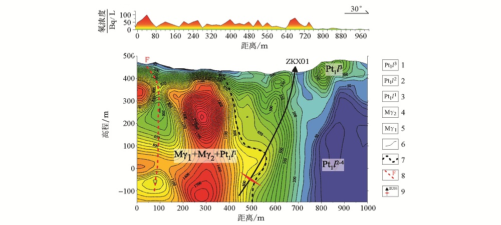
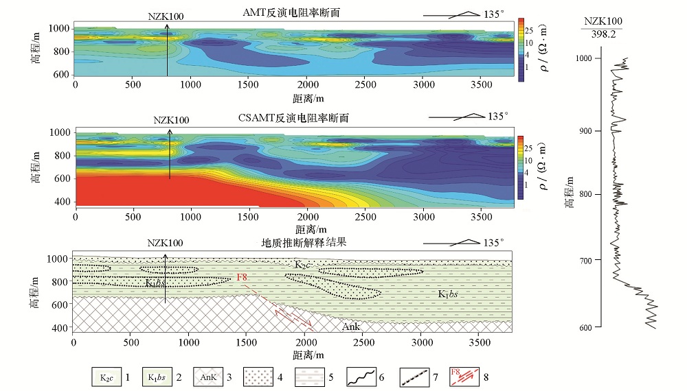
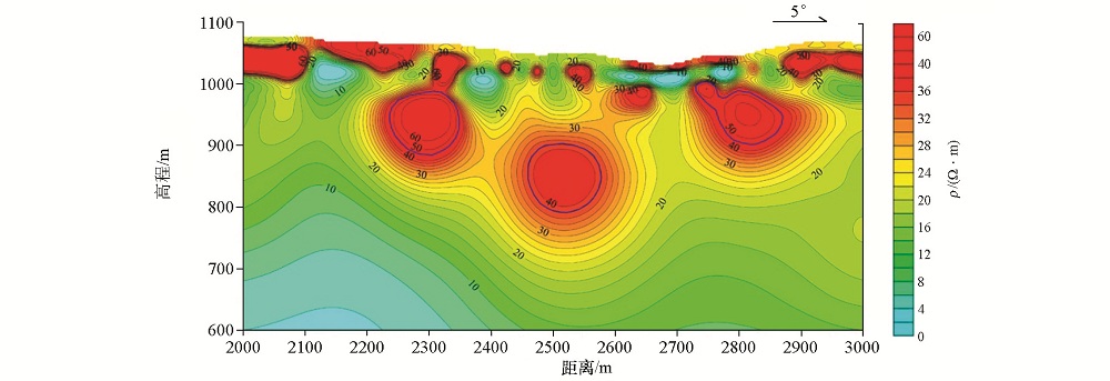
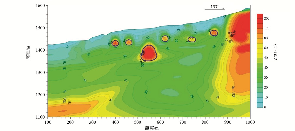
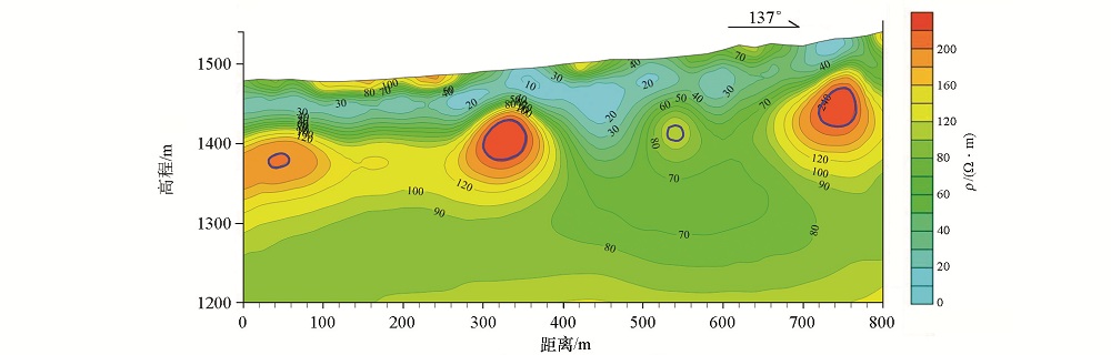
EH-4 has been applied to many fields, such as mineral exploration and engineering exploration. Nevertheless, because of the limitation of the acquisition frequency as well as geological and geophysical conditions, the application effects of EH-4 in different geological backgrounds are different. In order to prove the argument that the geological geophysical work in EH-4 is reasonable, the authors analyzed the EH-4 effects in exploration of Lianshangguan hard rock type uranium, sandstone type uranium deposit in Erlian Basin and mined out region of Yili basin in Xinjiang. The results show that, in the hard rock area, the depth of EH-4 exploration generally can reach 1000 m or so, and the detection of faults, the contact zone of rock bodies and its strike and spatial distribution can yield fairly good application effect; in sedimentary basins, the exploration effect of EH-4 is affected by the overall depth of resistivity and surface resistivity, the exploration depth may sometimes only reach two hundred or three hundred meters, but can sometimes reach five hundred or six hundred meters. Although the depth of exploration is not big, but the shallow geoelectric properties reflect good effect.
Ye Y X, Deng J Z, Fang G X . The test research of high frequency magnetotelluric sounding 12 to reservoir structure survey: taking the Fuzhou geothermal area in Jiangxi province as an example[J]. Geology and Exploration, 2011,47(4):649.
Xi Z Z, Feng W J, Li R X , et al. Effect of a low-resistivity cover on high-frequency magnetotelluric sounding[J]. Geology and Exploration, 2011,47(4):673.
Li B, Sun L F, Guo J Y , et al. The application of EH-4 technology to the Juzhugou gold ore district in western Henan Province[J]. Geophysical and Geochemical Exploration, 2016, 40(1):51-54.
Kong Z Z, Wu Y . A discussion on some EH-4 measurement problems in hard-rock areas in southern China:A case study of the Shazijiang deposit[J]. Geology and Exploration, 2016,40(4):804-808.DOI: 10.11720/wtyht.2016.4.26
Liu J X, Tong X Z, Cheng Y T , et al. Application of effective appar ent resistivity in two-dimensional inversion of EH-4 date[J]. Geology and Exploration, 2008,44(3):56.
Zhang Z L, Zeng Q D, Liu J M , et al. Application of GDP-32II and EH-4 to prediction of mineralization at depth[J]. Geology and Exploration, 2010,46(3):470.
Wu D, Liu X D . Survey report of uranium deposits in Lianshanguan-Qijiabaozi area, Benxi County, Liaoning Province[R]. 240 Research Institute of Nuclear Industry, 2014.
Li M, Niu Y, Wu Y . Report on Geophysical exploration in Lianshanguan-Qijiabuzi area,Benxi County,LiaoNing province[R]. Airbome Survey and Remote Sensing Center of Nuclear industry, 2012.
Niu Y, Xie M H, Wu Y Q . Report on geophysical survey in Wujiabaozi area, Benxi County, Liaoning Province[R]. Airbome Survey and Remote Sensing Center of Nuclear industry, 2014.
Kang S H . Development characteristics and uranium metallogenic model of paleochannel oxidation zone in the Eastern Wulanchabu Depression, Erlian Basin[J]. Journal of Henan polytechnic university(Natural Science), 2010,28(S):107.
[11]
谈成龙 . 古河道砂岩型铀矿的几种勘查方法[J]. 铀矿地质, 2000,16(3):164.
[11]
Tan C L . Several exploration methods for paleochannel sandstone-type Uranium Deposits[J]. Uranium Geology, 2000,16(3):164.
Zhang J W . The geophysical survey report of Saiwusu area in Ulanchabu depression, Erlian Basin, Inner Mongolia[R]. Airbome Survey and Remote Sensing Center of Nuclear industry, 2012.
Jiang H, Kang Y, Wu Y L . Design for 2013 census to the west of P0 line of Mongqigur uranium deposit, Chabuchaer County, Xinjiang[R]. 216 Brigade of Nuclear Industry, 2013.
Ji Z X . Report on the achievements of audio magnetotelluric survey in Suasu-Dala area, Southern Margin of Yili Basin, Xinjiang[R]. Airbome Survey and Remote Sensing Center of Nuclear industry, 2016.